Sign up for the Morning Brief email newsletter to get weekday updates from The Weather Channel and our meteorologists.
Superstorm Sandy was both record-breaking and unusual.
Because of that, there are many facts and figures about its meteorology and impacts that live freshly in our minds 10 years later. Here's a look back at some of those notables by the numbers.
(Visit our Superstorm Sandy page for more coverage of the 10th anniversary.)
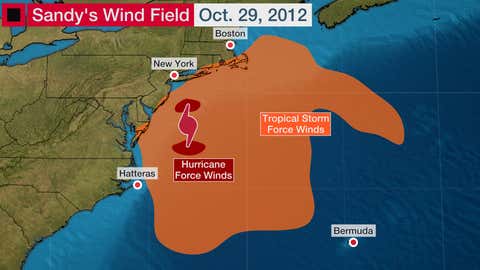
1,000
Sandy is the largest Atlantic tropical cyclone on record based on the extent of its tropical storm force wind field. Those winds of 39 mph to 73 mph were about 1,000 miles in diameter at their maximum when the storm approached landfall on Oct. 29, 2012.
The large size of Sandy also set into motion many of its wide-reaching impacts like storm surge, strong winds, rain and even mountain snow.
4
Sandy's late-season strike at such a far north latitude as well as its interaction with a strong jet stream disturbance means the National Weather Service had to issue a menagerie of alerts.
Those watches and warnings fell into four general buckets:
- High wind, including hurricane-force wind warnings along the coast.
- Flash flood and river flood for heavy rain.
- Coastal and lakeshore flooding for inundation along shorelines, even as far west as the Great Lakes.
- Winter storm and blizzard for heavy snow and strong winds in the Appalachians.

12.65
Sandy's massive wind field drove storm surge flooding from Florida to Maine, but it was the Northeast that bore the most destructive brunt.
In New York, Sandy's highest measured surge hit a record 12.65 feet above normal tide levels in western Long Island Sound at Kings Point. Connecticut and New Jersey had maximum storm surges measured at 9.83 feet (Bridgeport) and 8.57 feet (Sandy Hook), respectively.
The feet of seawater pushed by Sandy into this part of the coastline contributed to catastrophic damage in some areas.

945
Superstorm Sandy didn't technically make landfall as a hurricane or tropical storm, but when it finally came ashore near Atlantic City, New Jersey, during the evening of Oct. 29, 2012, it did so with an exceptional central pressure of 945 millibars.
That's exceptionally low pressure for a Northeast storm, but not quite as low as the infamous "Long Island Express" hurricane of 1938 (estimated 941 millibars).
All-time low pressure records were set in Philadelphia and Atlantic City, New Jersey, as well as other locations.
Sandy's extremely low pressure played a role in generating its large wind field, and therefore, its far-reaching impacts along the East Coast.

36
This might be the strangest number we associate with Sandy.
The superstorm's moisture collided with the higher elevations of the central and southern Appalachians, where just enough cold air was in place to produce up to 36 inches of snow in Richwood, West Virginia, and Wolf Laurel Mountain, North Carolina.
West Virginia was particularly hard hit by blizzard conditions, and the weight of the heavy, wet snow caused some structures to collapse.

72
A total of 72 people lost their lives in the mid-Atlantic and Northeast because of direct impacts from Sandy. That's the most people directly killed by a tropical cyclone in the continental U.S. outside of the South since Agnes in 1972.
Storm surge alone was responsible for 41 of the deaths, according to the National Hurricane Center report. High winds contributed to another 20 fatalities.

81.9
Damage from Sandy was estimated to cost $81.9 billion when adjusted for inflation.
That ranks as the fourth most costly tropical cyclone-related disaster in NOAA's database of billion-dollar disasters.
Katrina, Harvey and Maria are the only hurricanes to have a bigger price tag in U.S. records dating to 1980.
At this time, it's unknown if those rankings might change once the final cost of Hurricane Ian is settled.

8.5
Power outages blamed on Sandy impacted a cumulative 8.5 million customers. Some of those outages lasted weeks or even months, the NHC report said.
Those extended power outages were blamed on 50 of Sandy's 87 indirect deaths, which are separate from the direct deaths mentioned earlier.
Indirect deaths are those not caused by wind or water during an ongoing storm, but rather happen because of other circumstances. They often occur in preparation for a storm or in the aftermath of one.
Hypothermia in cold weather, falls in the dark by senior citizens and carbon monoxide poisoning are some of the reasons for indirect deaths from power loss during the storm.

The Weather Company’s primary journalistic mission is to report on breaking weather news, the environment and the importance of science to our lives. This story does not necessarily represent the position of our parent company, IBM.