 Yahoo奇摩新聞
熱帶性低氣壓
- 台灣新生報 • 5 小時前
南市全面戒備防範熱帶性低氣壓增強為颱風 加強巡檢易淤塞排水路落實防汛
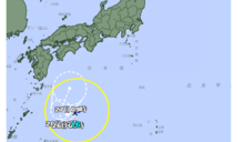
▲南市全面戒備,防範熱帶性低氣壓增強為颱風,加強巡檢易淤塞排水路及落實抽水站、水閘門操作測試。(記者李嘉祥攝) 依據中央氣象署預報資料,位於琉球南方海面的低氣壓27日已發展為熱帶性低氣壓,預估28日將進一步增強為颱風,易有強風降雨發生,臺南市長黃偉哲要求市府團隊加強整備,也呼籲市民留意氣象資訊,做好防颱準備,儘量避免前往山區、水岸、沿海,以維護自身安全。 市長黃偉哲表示,今年汛期較往年雨量多,面對此次熱帶性低氣壓可能形成颱風帶來的雨勢,雖然主要影響...
 Yahoo奇摩新聞(報氣象) • 7 小時前
一分鐘報天氣 / 週六 (09/28) 熱帶性低氣壓漸增強逼近 下週北部及東部防範強風大雨
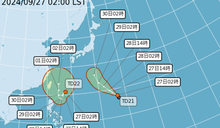
明天天氣如何? 目前西北太平洋上存在兩個熱帶性低氣壓,分別為TD21及TD22,兩個系統在未來三天內都有機會依序增強為今年第17號颱風燕子(Jebi)及第18號颱風山陀兒(Krathon),TD21距離臺灣遙遠,即使增強為颱風,預測對臺灣是沒有影響的。 TD22未來的發展將對於臺灣的天氣有很大的相關聯了,預測顯示TD22週末(28-29日)持續位於臺灣東南方海面,並將增強發展成輕度颱風,導致週末兩日臺灣有東北風增強的情況,沿海風浪有逐漸...
- 台視新聞網 • 6 小時前
熱帶性低氣壓最快今晚成颱!「V型大迴轉」北上 這2天最接近台灣
位在台灣東方海面的熱帶性低氣壓TD22,氣象署預估,最快在今(27)天晚間到明(28)天清晨,有機會增強為颱風,根據預報路徑顯示,TD22先往南移動,到了週日、週一會來個V型大迴轉,逐漸北上,緊接著週
- 中廣新聞網 • 5 小時前
燕子颱風生成! 準山陀兒接力「不排除發陸警」
氣象署今天(27日)表示,位於關島附近的熱帶性低氣壓已經生成今年第17號颱風「燕子」,預計未來朝日本南方海面前進,對台灣沒有影響。另一個台灣東方的熱帶性低氣壓最快今晚增強為第18號颱風「山陀兒」,不排
- 台灣好新聞 • 11 小時前
熱帶性低氣壓將增強為颱風 黃偉哲呼籲市民防範強風降雨
中央氣象署預報,位於琉球南方海面的低氣壓已發展為熱帶性低氣壓,預估9月28日將進一步增強為颱風,易有強風降雨發生。市長黃偉哲已要求市府團隊加強整備,並呼籲市民留意氣象資訊,做好防颱準備,儘量避免前往山區、水岸、沿海,以維護自身安全。市長黃偉哲表示,今年汛期相較往年雨量甚多,因此面對這次熱帶性低氣壓可能形成颱風帶來的雨勢,雖然主要影響範圍為東北部,但所處環境適宜,不排除持續增強,已要求市府團隊及各區公所務必持續加強整備,並特別針對易淤塞排水路...
- Yahoo奇摩(即時新聞) • 7 小時前
颱風接力!「燕子」朝日本南方海面前進 「山陀兒」最快今晚生成9/30到10/2最近台
交通部中央氣象署今天表示,位於關島附近的熱帶性低氣壓下午增強為今年第17號颱風燕子,預計未來朝日本南方海面前進,對台灣沒有影響。位於台灣東方的熱帶性低氣壓最快今晚到明天清晨增強為輕度颱風山陀兒,最靠近台灣的時間點為9月30日到10月2日。
- TVBS新聞網 • 7 小時前
快訊/燕子颱風生成 日本氣象廳曝最新路徑:又是短命颱
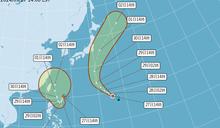
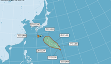
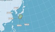
西北太平洋上有2個熱帶性低氣壓,分別為TD21及TD22。日本氣象廳今(27)日下午宣布,熱帶低氣壓TD21增強為今年第17號颱風「燕子颱風」,預計將持續朝西北移動,初步判斷對台灣不會造成影響。至於位於沖繩南方的TD22則緩慢地朝南偏西方向移動,預計在28日上午7點增強發展成颱風「山陀兒」,對沖繩帶來影響。
- 台視新聞網 • 10 小時前
颱風假?氣象專家示警颱風恐登陸 「4地區」暴風圈籠罩機率高
中央氣象署表示,位於琉球南方海面第22號熱帶性低氣壓,未來有機會成為17燕子或18山陀兒颱風,預估假日起開始受到外圍環流的影響,且下週一至三為影響最明顯的時候。天氣粉專《台灣颱風論壇|天氣特急》發文指
- 華視 • 10 小時前
颱風最快今晚生成「恐以中颱強度接近」 不排除發布海警陸警
中央氣象署表示,關島東方海面的第21號熱帶性低氣壓,未來有發展為輕度颱風的趨勢,距離台灣遠且維持颱風強度的時間不長,對台灣沒有直接影響;原位於琉球南方海面的低氣壓,於今(27)日清晨增強為第22號熱帶...
- 台視新聞網 • 15 小時前
燕子名字被搶!準「山陀兒」颱風預計明生成 下週2區影響最大
氣象專家林得恩今(27)日指出,目前西北太平洋出現兩個熱帶性低氣壓,原先的準「燕子」颱風可能因為靠近關島的熱帶性低氣壓率先生成,而改名成「山陀兒」颱風,預計將在明日清晨前後生成,且強度恐達中颱。氣象署
- 鏡週刊Mirror Media • 15 小時前
低壓週末成颱!直撲台灣連3日雨彈狂襲 一張圖掌握資訊
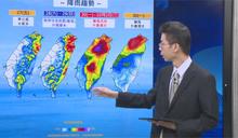
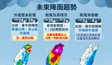
根據中央氣象署,今日(27日)台灣受東北風影響,北部及東半部地區的降雨明顯增加,基隆北海岸、大台北山區及東半部地區更有局部大雨的可能,民眾外出務必攜帶雨具。此外,第22號熱帶性低氣壓預計週末成颱,週一(30日)起朝台灣東方海面靠近並逐漸通過,下週一至週三對台灣天氣影響最大。
- EBC東森新聞 • 10 小時前
準「山陀兒」颱風不排除發布陸警 影響台灣關鍵時間曝
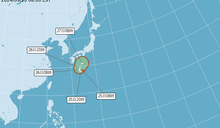
目前位於台灣東部太平洋海域上的熱帶性低氣壓TD22,今(27日)中心位置位於台灣東南方、琉球南方海面上,中央氣象署評估最快可能在明(28日)生成為颱風「山陀兒」(KRATHON),預估周日(29日)開始外圍環流會影響台灣,下周一至二(10月1日至2日)最接近台灣,甚至不排除發海警跟陸警。 氣象署科長徐仲毅表示,目前有兩個熱帶低氣壓,其中離台灣比較近的熱帶性低氣壓TD22,大約距離600公浬海面上,今日8時的中心位置在北緯20.8度,東經126.7度,以每小時...
- CTWANT • 1 天前
雙熱帶系統發展!準「山陀兒」不排除登陸 北東雨勢明顯
[周刊王CTWANT] 根據氣象署表示,熱帶性氣低壓TD21預估明日有機會增強颱風「燕子」(Jebi,韓國提供),不過發展條件不好很快會減弱,另外在台灣東方海面的低氣壓,所處環境較適合發展,將成為熱帶性低氣壓,預估周六、日增強為颱風「山陀兒」(泰國提供,水果名)。不過氣象署表示,未來要...
- 中天新聞網 • 1 天前
明起恐迎雙颱共舞!準「山陀兒」不排除下週登陸 北東雨勢最大
中央氣象署指出,關島附近的熱帶性低氣壓TD21可能在27日增強為新颱風「燕子」(JEBI),台灣東方的熱帶擾動最快也會在週末升級輕颱,有機會在下週為北東帶來大雨。
- 三立新聞網 setn.com • 14 小時前
颱風山陀兒最快明生成!恐達中颱發海警 鄭明典「曬1圖」:很靠近台灣
目前西北太平洋地區有2個熱帶性低氣壓,對此,前中央氣象局長鄭明典表示,第22號熱帶性低氣壓(TD22)很靠近台灣。
- EBC東森新聞 • 15 小時前
颱風燕子名字被搶!山陀兒逼近台灣 1原因影響加劇
今(27)天仍受東北風影響,水氣有增多的趨勢,北部、東半部地區、恆春半島及馬祖降雨機率高,不定時會有短暫陣雨甚至雷雨,此外,目前位於台灣東部太平洋海域上的熱帶性低氣壓TD22,有可能不會是「燕子」颱風,因為在關島又出現熱低壓生成,很可能會搶先用走燕子之名。 氣象署表示,今天尤其基隆北海岸、大台北山區及東半部地區雨勢較明顯,有局部大雨發生的機率,而中南部及澎湖、金門則為多雲到...
- 鏡週刊Mirror Media • 1 天前
又出現熱帶低壓!「燕子」颱風最快24小時內生成 移動路徑曝光
中央氣象署說明,今(26日)下午2時許日本關島附近正式生成第21號熱帶性低氣壓,預估24小時內有機會增強為颱風,對台灣沒有影響,另台灣東方有低氣壓正在組織中,預計下週一至三影響台灣最大,仍在持續觀察中。
- 民視 • 1 天前
燕子颱風來勢洶洶 未來「這幾天」中部以北降雨恐「紫爆」
即時中心/林耿郁報導近期天氣十分不穩定,台灣東方海面上又出現熱帶系統,未來很可能會形成熱帶性低氣壓、甚至17號颱風「燕子」;中央氣象署預報員張承傳在今(26)日下午3點半的記者會中表示,未來這個系統形成颱風的機會「非常大」,且下週一至三(9/30-10/2)將是影響台灣天氣最劇烈的時刻!
- CTWANT • 1 天前
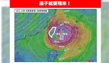
準颱風燕子週末生成「影響時間曝」! 氣象專家示警:強度恐中颱以上
[周刊王CTWANT] 台灣大學大氣科學博士林得恩今稍早在臉書粉專《林老師氣象站》發文指出,「燕子就要飛來!」原位於日本南方海面的熱帶性低氣壓,已於昨午增強為今年第16號颱風西馬隆,預估後續路徑將循環境駛流場導引,往日本關東移動、對我臺灣無直接影響,「由於西馬隆颱風結構不佳,加上...
- Yahoo奇摩(綜合報導) • 2 天前
今迎風面水氣增「北部、東半部降雨機率高」颱風燕子最快周末生成
中央氣象署表示,今天(26日)開始東北風逐漸影響,迎風面水氣增多,北部、東半部地區降雨機率高,外出請攜帶雨具備用。明天天氣如何?氣象署指出,明天東北風影響及水氣偏多,迎風面的桃園以北及東半部地區不定時有短暫陣雨或雷雨,其中基隆北海岸、大台北山區及宜、花地區有局部大雨發生的機率,目前太平洋地區有一個輕颱西馬隆,對台灣天氣無直接影響;中央氣象署預報員黃恩鴻提醒,琉球群島附近的熱帶系統,預估周末有機會增強為熱帶性低氣壓或颱風,若成颱將會是今年第17號颱風燕子。
- 中天新聞網 • 2 天前
「燕子」成颱機率80%!暴風圈大「強度至少中颱」 預估10/1、10/2風雨最強
中央氣象署表示,琉球群島一帶的熱帶系統,周末有機會增強為颱風「燕子」。氣象專家林得恩今(26日)發文分析,增強為熱帶性低氣壓或颱風的機率高達80%。
- Yahoo奇摩(即時新聞) • 2 天前
颱風西馬隆生成 留意琉球群島熱帶系統 周末恐影響台灣
中央氣象署今天表示,位於日本南方海面的熱帶性低氣壓增強為今年第16號颱風西馬隆,預估往日本關東移動、對台無影響;西馬隆結構不佳,預估24小時左右就會減弱。台灣需留意琉球群島一帶的熱帶系統發展,本周末可能會對台造成影響,不排除會增強為熱帶性低氣壓或颱風,若成颱將會是今年第17號颱風燕子。
- 鏡週刊Mirror Media • 2 天前
颱風「西馬隆」中午生成! 氣象粉專提醒:週末可能也有颱風
日本氣象廳中午宣布,位於日本南方海面的熱帶性低氣壓增強為第16號颱風「西馬隆」,預計不會發展很快就會消散。對此,中央氣象署稱其對台灣並無影響,不過週末可能有另一個颱風生成。
- 民視影音 • 1 天前
燕子颱風來勢洶洶 未來「這幾天」中部以北降雨恐「紫爆」
即時中心/林耿郁報導 近期天氣十分不穩定,台灣東方海面上又出現熱帶系統,未來很可能會形成熱帶性低氣壓、甚至17號颱風「燕子」;中央氣象署預報員張承傳在今(26)日下午3點半的記者會中表示,未來這個系統形成颱風的機會「非常大」,且下週一至三(9/30-10/2)將是影響台灣天氣最劇烈的時刻! 氣象署預報表示,從地面天氣圖可以看到,目前台灣東方外海一直到關島,都是一片大低壓帶;有相當多的低壓系統;其中原本的16號颱風西馬隆,已經在今(26)天下午2點減弱...
- 三立新聞網 setn.com • 2 天前
今晚恐增強為「西馬隆」颱風!預測路徑曝光 下個颱風「燕子」離台較近
日本氣象廳資料顯示,日本南方海面新的熱帶性低氣壓生成。中央氣象署指出,最快今(25)日晚間有可能增強為颱風「西馬隆」,預估路徑曝光。
- 新頭殼 • 2 天前
快訊》颱風生成趕進度!16號颱「西馬隆」生成 氣象署曝可能走向
[Newtalk新聞] 根據日本氣象廳資料顯示,位於日本南方海面的低氣壓,今(25)日一早發展為熱帶性低氣壓,而原先中央氣象署預估今晚會再增強為今年第16號颱風「西馬隆」。不過,日本氣象廳中午指出,熱帶性低氣壓,已增強為颱風「西馬隆」,中央氣象署指出,颱風路徑往日本移動。 根據氣象署資料,今日8時熱帶性低氣壓TD20的中心位置在北緯28.4度,東經134.6度,以每小時6公里速度,向西南進行。中心氣壓1004百帕,近中心最大風速每秒12公尺,瞬間最大陣風每秒20公尺...
- 新頭殼 • 3 天前
又有熱帶低壓生成!可能路徑曝光 氣象署:預估今晚成颱
[Newtalk新聞] 又有新熱帶性低氣壓生成,位於日本南方海面的低氣壓,在今(25)日發展為熱帶性低氣壓。中央氣象署說,最快今晚有機會增強為今年第16號颱風「西馬隆」,但對台灣天氣沒有影響。 根據氣象署資料,今日8時熱帶性低氣壓TD20,的中心位置在北緯28.4度,東經134.6度,以每小時6公里速度,向西南進行。中心氣壓1004百帕,近中心最大風速每秒12公尺,瞬間最大陣風每秒20公尺。 氣象署預報員黃恩鴻表示,從日本預報資料來看,該熱帶低氣壓強度結構滿弱的,但...
- 民報 • 7 小時前
【更新】燕子颱風今生成、山陀兒颱風最快周末生成 北東風雨逐漸增強
燕子颱風今(27)日14時發展為輕度颱風,而位於台灣東方的低氣壓,最快周六生成為「山陀兒」颱風,下周一至下周三影響台灣最大,各地都有降雨。
- Yahoo奇摩(綜合報導) • 15 小時前
今北部、東半部降雨機率高! 「颱風將生成」下周一起影響最明顯
...地區、恆春半降雨機率高,尤其基隆北海岸、大台北山區及東半部地區雨勢較明顯,中南部則有午後雷陣雨。明天天氣如何?氣象署指出,明天、周日(28日、29日) 迎風面北部、東半部持續有短暫陣雨或雷雨,且北部及宜蘭降雨較明顯,午後對流發展旺盛,嘉義以南地區有局部較大雨勢發生的機率。氣象署提醒,原位於琉球南方海面的低氣壓,短期內有發展為颱風的趨勢,且距離台灣較近,預估假日起開始受到外圍環流的影響,下周一至下周三(9月30日到10月2日)為影響最明顯的時候。