 Yahoo奇摩新聞
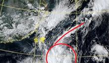
鄭明典
- 三立新聞網 setn.com • 6 小時前
準山陀兒最新狀態曝!鄭明典曬「6字形」特性:發生共伴
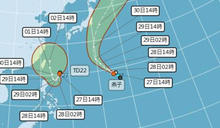
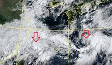
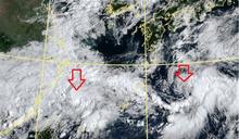
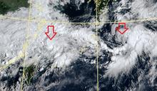
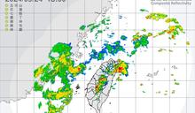
根據中央氣象署指出,位在台灣東面的熱帶低壓TD22,預估週日時迴轉回到台灣東部海面北上前進,下週一至週三影響台灣最大,預測強度為中度颱風、暴風圈掃到台灣機率很高。對此,前氣象局長鄭明典也以TD22「6字形」的狀態解釋「颱風與東北季風發生共伴」。
- 中天新聞網 • 6 小時前
準「山陀兒」在台灣東方現6字形特徵 鄭明典:與東北季風發生共伴
繼燕子颱風生成,琉球南方海面的熱帶性低氣壓TD22也將增強為第18號颱風「山陀兒」,前中央氣象局長鄭明典說,TD22和1條弧狀的對流雲帶組成「6」字形,和東北季風發生共伴。
- CTWANT • 4 小時前
準「山陀兒」將生成…最快周日發海警 鄭明典揭台灣東方「6」字形原理
[周刊王CTWANT] 中央氣象署指出,TD22熱帶性低氣壓今天14時的中心位置在北緯20.5度,東經126.4度,以每小時14公里速度,向南南西進行,中心氣壓1002百帕,近中心最大風速每秒15公尺,瞬間最大陣風每秒23公尺,預估今晚到明天清晨增強為輕颱,周末受到外圍雲系影響,北部和東半部有間歇性降雨...
- 新頭殼 • 14 小時前
熱帶低壓組織中最快明成颱!鄭明典示警:「山陀兒」很靠近台灣
[Newtalk新聞] 根據中央氣象署資料,第22號熱帶性低氣壓於今(27)日凌晨成颱,目前持續向西南西進行,中央氣象署預估由於該熱帶低壓組織當中,最快明天才會增強為颱風「山陀兒」。前中央氣象局長鄭明典在臉書上表示,熱帶系統很靠近台灣,但南側目前的垂直風切稍大,發展還需要一段時間。 氣象署指出,第22號熱帶性低氣壓2時的中心位置在北緯21.2度,東經127.1度,以每小時7公里速度,向西南西進行。中心氣壓1004百帕,近中心最大風速每...
- 中天新聞網 • 14 小時前
最快明清晨生成!準颱風「山陀兒」恐達中颱 鄭明典:很靠近台灣
近期颱風接龍生成,氣候也十分不穩定,而西北太平洋目前有2個熱帶性低氣壓,前中央氣象局長鄭明典也在臉書發文表示,第22號熱帶性低氣壓(TD22)很靠近台灣。
- 民視 • 16 小時前
雙颱接力生成!山陀兒「恐達中颱」等級 鄭明典:很靠近台灣
即時中心/周欣儀報導氣象局指出,西北太平洋目前有兩個熱帶性低氣壓,其中第22號(TD22)已接近台灣。前中央氣象局長鄭明典表示,TD22的旋轉中心原本偏北,但西南側的強對流受到高層輻散的支持,影響系統發展。
- 三立新聞網 setn.com • 16 小時前
颱風山陀兒最快明生成!恐達中颱發海警 鄭明典「曬1圖」:很靠近台灣
目前西北太平洋地區有2個熱帶性低氣壓,對此,前中央氣象局長鄭明典表示,第22號熱帶性低氣壓(TD22)很靠近台灣。
- 民視 • 2 天前
秋颱接連生成?鄭明典揭「3個旋轉雲團」曝關鍵
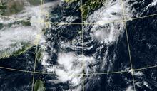
...受到東北風影響,迎風面水氣增多,台灣北部、東半部地區及金門、馬祖雲量偏多,且降雨機率高,局部有短暫陣雨甚至雷雨出現,清晨至上午桃園以北地區有局部較大雨勢發生的機率,溫度方面,各地高溫普遍為30至32度,而低溫則落在24至26度,感受舒適涼爽;不過目前太平洋上有3個旋轉雲團正在擾動,包括今年第16號輕度颱風「西馬隆」,未來也可能成颱的17號颱風「燕子」也正在生成,對此,前氣象局長鄭明典提醒,儘管這三個選轉雲團距離很遠,但要小心彼此之間還是會有牽連。
- 天氣多一典 • 4 天前
天氣進入秋季 秋天的颱風就是「秋颱」嗎?鄭明典:共伴效應是重點|YahooTV《天氣多一典》
天氣準備進入到秋季,侵台颱風就要特別注意「共伴效應」,造成北部、東北部雨災。前氣象局長鄭明典在Yahoo TV《天氣多一典》節目中表示,儘管並非所有秋季的颱風都會產生「共伴效應」,但是就統計而言機率確實比較高,為了區分差別,預報員也習慣將會產生「共伴效應」的颱風稱為「秋颱」,一般的則稱為「秋天的颱風」。
- 華視 • 4 天前
海上2低壓互動將影響台灣天氣 鄭明典:已經發生藤原效應
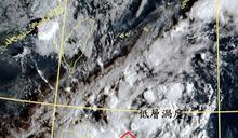
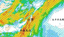
近日受鋒面及低壓帶影響,台灣附近水氣偏多、天氣不穩定。前中央氣象局長鄭明典今(24)日於臉書上發出一張衛星雲圖,表示有兩個旋轉中心,這兩個低壓的互動可能影響台灣未來的天氣。鄭明典今日在臉書上曬出一張衛...
- 中天新聞網 • 3 天前
海面2低壓「產生藤原效應了」!鄭明典示警:恐影響台灣天氣
連日大雨讓全台多處都淹大水,不過目前鋒面北移雨勢漸緩。前氣象局長鄭明典po出衛星雲圖指出,台灣附近海面上有兩個低壓,目前已產生藤原效應,可能影響台灣未來的天氣。
- 三立新聞網 setn.com • 4 天前
海面有2個旋轉中心!鄭明典PO圖:2低壓互動恐影響未來天氣
前中央氣象局長鄭明典今(24)日在臉書PO出衛星雲圖,並表示海面上有兩個旋轉中心,對照模式,這兩個小低壓模式都有掌握,「左側這個似乎比模式預測的明顯!」這兩個低壓的互動,可能影響台灣未來的天氣,可以好好觀察。
- 中時新聞網 • 4 天前
海面2低壓「產生藤原效應了」鄭明典:恐影響台灣
全台連日降雨不斷,前中央氣象局長鄭明典貼出衛星雲圖指出,在台灣北方的海面上有兩個旋轉中心,這兩個低壓的互動,可能影響台灣未來的天氣,並指出兩個低壓已經發生藤原效應了。
- 鏡週刊Mirror Media • 4 天前
2個低壓在海上!恐影響台灣天氣 鄭明典:藤原效應正在發生
近日連日大雨讓北部地區多處淹水,不過目前降雨趨緩,但預計晚上將有鋒面再通過,又會有降雨發生。前中央氣象局長鄭明典發文指出,目前有2個低壓的「旋轉中心」在我國附近,已正在發生藤原效應,恐影響台灣天氣。
- 新頭殼 • 3 天前
海面2低壓產生「藤原效應」!鄭明典示警:可能影響台灣
[Newtalk新聞] 今(24)日入夜後有鋒面通過,北部、東部需慎防較大雨勢。前中央氣象局長鄭明典也發出衛星雲圖,指出台灣附近海面「有兩個旋轉中心」,會產生「藤原效應」,並示警「這兩個低壓的互動可能影響台灣未來的天氣」。 中央氣象局表示,今晚入夜至明日,北方鋒面將再度通過北台灣,北部及東部轉有廣泛短暫陣雨或偶雷雨。但鋒面強度減弱,對中南部的影響較小,將持續為晴時多雲,午後山區熱對流短暫雷陣雨天氣。週四(26日)持續受到低壓帶影響,主要的降雨...
- 民視 • 3 天前
雙低壓形成"藤原效應"影響台灣天氣? 氣象署:續觀察
生活中心/孟嘉美、談駿豪 台北報導前氣象局長鄭明典在臉書PO出衛星雲圖,指出台灣周邊兩顆低壓旋轉中心,已經出現藤原效應,之後可能會對台灣天氣造成影響。不過對此,氣象署態度很保守,只說目前看不太出來,還要再繼續觀察。只不過,週二白天雨勢稍微減緩之後,晚間開始降雨狀況又會不斷!
- 中天新聞網 • 4 天前
2天降雨逾400毫米!鄭明典曬圖「有梅雨味道」 氣象署:共伴效應
暴雨襲全台,各地淹水災情頻傳,前氣象局長鄭明典表示,最近的天氣型態,有一點「梅雨」的味道。氣象署也說明,東北風與西南風產生共伴效應,才會降下豪大雨。
 天氣多一典 • 4 天前
秋颱是什麼?秋天的颱風就是「秋颱」嗎?鄭明典:共伴效應是重點
天氣準備進入到秋季,侵台颱風就要特別注意「共伴效應」,造成北部、東北部雨災。前氣象局長鄭明典在Yahoo TV《天氣多一典》節目中表示,儘管並非所有秋季的颱風都會產生「共伴效應」,但是就統計而言機率確實比較高,為了區分差別,預報員也習慣將會產生「共伴效應」的颱風稱為「秋颱」,一般的則稱為「秋天的颱風」。
- 天氣多一典 • 4 天前
海面2低壓產生「藤原效應」鄭明典分析:左邊的有機會往南,影響台灣機率較大
YahooTV《天氣多一典》節目主持人、前中央氣象局長鄭明典今天早上在臉書發文指出,目前有2個低壓的「旋轉中心」在台灣附近,已正在發生藤原效應,恐影響台灣天氣。
- 中天新聞網 • 6 天前
鄭明典「曬1圖」!「小冷空氣南下」可視為即將入秋
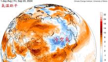
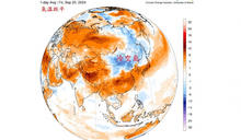
近期受到熱帶性低氣壓外圍雲系及低氣壓影響,降雨不斷,氣溫也有些下降,前中央氣象局局長鄭明典今(21)日在臉書發文表示,有小股冷空氣南下,可視為將入秋。
- 新頭殼 • 6 天前
明起降溫轉涼!鄭明典:小股冷空氣南下
[Newtalk新聞] 熱帶擾動發展今(21)日將抵達台灣附近,明起對台灣帶來明顯降雨。前中央氣象署署長鄭明典也指出,未來預估將會有小股冷空氣南下,且因降雨影響,溫度將略降,明晚到下週一探25度。 隨著熱帶性低氣壓北上,加上位於南海北部的另一個季風低壓中心,共同連結成大範圍的低壓帶環境,造成天氣不穩定。明日至下週一因為北邊有大陸高壓帶來的東北季風南下,台灣附近形成南北風交會的低壓帶環境,各地都將有陣雨或雷雨,並且有局部大雨甚至豪雨發生的可能性...
- EBC東森新聞 • 5 天前
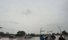
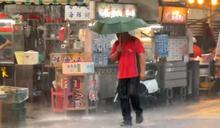
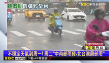
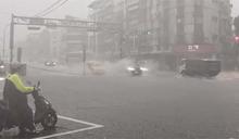
大雨一直下!南部下到發紫 鄭明典:西南氣流影響
受熱帶性低氣壓和低壓帶影響,全台溼答答,以北部來看,雖然上半天有趨緩,但中午後又變天,而南部地區更是下到發紫;對此,前氣象局長鄭明典表示,南部地區已經受到西南氣流影響,預估等要等到周二後低壓帶遠離,雨勢才會趨緩。 今日雨勢驚人。(圖/東森新聞) 上午好不容易獲得空檔的北部,午後再變天,整片天空灰矇矇大雨一直下,其他地區同樣也「雨神同行」,尤其南部更...
- 三立新聞網 setn.com • 6 天前
換季時間來了!鄭明典「曬1圖」:冷空氣南下
今(21)日受熱帶性低氣壓外圍雲系及低氣壓影響,環境不穩定,西半部、宜蘭、臺東地區及澎湖不定時有短暫陣雨或雷雨出現,且有局部大雨發生的機率。不過前中央氣象署署長鄭明典就指出,未來預估將會有小股冷空氣南下,帶來秋天的訊號,可以視為季節轉變徵兆。
- 東森新聞影音 • 5 天前
大雨一直下! 南部下到發紫 鄭明典:西南氣流影響
受熱帶性低氣壓和低壓帶影響,全台溼答答,以北部來看,雖然上半天有趨緩,但中午後又變天,而南部地區更是下到發紫,對此前氣象局長鄭明典就說,南部地區已經受到西南氣流影響,預估等要等到周二後低壓帶遠離,雨勢才會趨緩。 #鄭明典#熱帶性低氣壓#低壓帶
- 民視 • 5 天前
豪雨狂炸台灣!鄭明典急籲「3地區」下到發紫:要小心了
生活中心/郭嘉柔報導豪雨狂炸台灣,不僅高雄六龜因土石流急疏散居民,就連新北汐止的經濟部標檢局水管疑似破裂加上雨勢影響,導致積水較高,讓牆面出現倒塌狀況。今(22)日,中央氣象署指出,受到熱帶性低氣壓及低壓帶影響,各地出現陣雨、雷雨,雖然明(23)日清晨各地的降雨會減少,但大台北及宜蘭山區仍有局部大雨出現。前氣象局長鄭明典則在稍早透過社群平台發文提醒,南部雨勢並未減緩,「累積到紫色範圍,很需要關注!」。
- 中天新聞網 • 7 天前
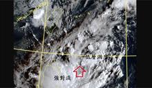
有機會放颱風假?熱帶低壓貼近台北 鄭明典示警:注意強對流出現
前氣象局長鄭明典今(21日)貼出一張衛星雲圖,指出台灣附近出現兩個旋轉中心,雖然熱低強度不高,但是受地形影響,仍要注意會有意外的強對流出現!
- CTWANT • 5 天前
低壓雨彈下不完!鄭明典曬圖揭降雨熱區 這日雨勢才趨緩
[周刊王CTWANT] 氣象署指出,今(22日)受熱帶性低氣壓及低壓帶影響,環境不穩定,台灣各地降雨機率偏高,易有短延時強降雨,北部、南部、東南部地區及金門、馬祖有局部豪雨發生,其中南部地區整天雨勢明顯偏強,北部地區預計中午過後雨勢變大增強,其他地區及澎湖亦有局部大雨發生的機率,...
- FTNN新聞網 • 6 天前
秋天訊號到!「冷空氣南下圖」曝光 鄭明典:是季節轉變徵兆
[FTNN新聞網]記者李惠婷/綜合報導怕熱星人狂喜!台灣夏日炎炎,本月最高溫甚至突破35度,讓民眾工作、逛街都汗如雨下,只想躲進冷氣房。前中央氣象局長鄭明...
- CTWANT • 6 天前
秋天即將來臨? 鄭明典:看到小股「冷空氣」南下
[周刊王CTWANT] 前氣象局局長鄭明典在FB發文表示,這股冷空氣和西南季風遭遇,會有一些鋒面生成過程,會是雨比較多的鋒面,但是影響地區仍然偏北,台灣在「邊緣」,主要還是偏南風的影響。而根據《ETtoday新聞雲》報導指出,中央氣象署預報員陳姵安受訪時表示,雖然目前台灣周邊仍處於大低壓...
- 太報 • 6 天前
秋意來了!鄭明典po「1張圖」:看到小股冷空氣南下
漫長的夏天即將劃下句點。前中央氣象局長鄭明典今天(9/21)在臉書貼出一張圖表示,目前已看到小股冷空氣南下,對中緯度來說還不算真的冷,但已可以帶來秋天訊息,可以視為季節轉變徵兆。