 Yahoo奇摩新聞
防災工程技術顧問公司
- 壹蘋新聞網 • 1 天前
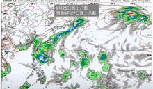
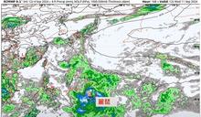
燕子颱風挾7級暴風圈 下周影響台灣最明顯
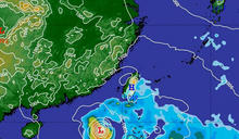
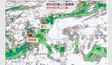
【施養正/綜合報導】近日琉球群島附近生成一股熱帶性低氣壓,台灣整合防災工程技術顧問公司總監賈新興26日指出,有機會在27、28日發展成颱風「燕子」,其7級暴風圈有可能影響台灣,預計10月1、2日最為明顯。此外,27日至10月初受低壓帶偏東北風影響,北部、東北部早晚偏涼。
- 三立新聞網 setn.com • 2 天前
又有颱風生成?「燕子」27、28日成颱機率高 專家:未來5日天氣轉涼
位在琉球群島東南方有熱帶系統發展的可能性,台灣整合防災工程技術顧問公司總監賈新興今(26)在YouTube頻道「Hsin Hsing Chia」表示,週五、週六熱帶系統發展成今年第17號颱風「燕子」很高,預估10月1日至2日燕子颱風影響台灣最劇,未來仍需觀察未來發展及預測路徑。(周宸妘)
- CTWANT • 5 天前
各地陰雨「午後易有較大雨勢」…未來10天雨區曝 周末恐有熱帶系統發展跡象
[周刊王CTWANT] 林孝儒臉書粉專「天氣風險 WeatherRisk」發文提到,今天台灣仍處於低壓帶的影響範圍內,且海峽北部還有弱北風及南風交會現象,會帶來些不穩定條件,因此預測各地天氣陰時多雲,短暫陣雨或雷雨,除迎風的中南部有些降雨外,午後多少搭配些熱力因素,中北部及東部地區容易出現...
- CTWANT • 3 天前
入夜鋒面再掃北台又轉雨!2地區「明起降溫」早晚偏涼
[周刊王CTWANT] 分析師林孝儒今天在氣象粉專「天氣風險 WeatherRisk」發文表示,隨著鋒面北抬整體降雨有所緩和,中南部至花東地區為晴時多雲天氣,午後山區有熱對流短暫雷陣雨機會,北部及宜蘭地區仍受局部鋒面雲系影響,午後可能還是有機會伴隨熱力作用,山區有熱對流雷陣雨及較大雨勢可能...
- 中廣新聞網 • 5 天前
未來一週雨區曝光! 賈新興:「這天」開始轉涼、9月底恐有熱帶低壓
氣象專家賈新興指出,明天(24日)午後各地有局部陣雨或雷雨,周三(25日)到周日(29日)受到低壓帶偏東北風影響,北部及東北部早晚略涼,雨會比較多,其他地區則會有午後雷陣雨。 台灣整合防災工程技
- 三立新聞網 setn.com • 2024年9月10日 下午 03:40
可能3颱共舞!賈新興曝「最快明早生成」 對台影響曝光
生活中心/黃依婷報導 今年第14號和第15號熱帶性低氣壓分別於今晨2時和9時生成!對此,氣象專家就指出,根據預測來看明天早上左右,2個熱帶性低氣壓都有成颱的機率,並曝
- CTWANT • 2024年9月10日 上午 11:23
「雙颱趕進度」中秋烤肉注意了! 賈新興曝「貝碧佳、葡萄桑」恐接力生成
[周刊王CTWANT] 「台灣颱風論壇|天氣特急」今早發文說明,第13號貝碧佳、第14號葡萄桑,有機會在不久的將來誕生,粉專進一步說明,「94W位於日本那霸西方,持續往中國浙江前進,今明受其外圍環流影響,北部地區容易下雨,尤其山區下雨時間長,有間歇大雨機會;登陸之前有機會成為颱風。」...
- CTWANT • 2024年9月6日 早上 08:59
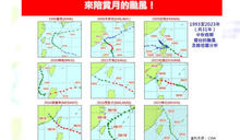
歷年中秋颱風「過半是強颱」! 氣象專家:熱帶擾動成颱後「這2天」接近台灣
[周刊王CTWANT] 台灣大學大氣科學博士林得恩今清晨在臉書粉專《林老師氣象站》發文貼出1993至2023年中秋假期擾台的颱風及路徑圖,並指出分別是1996年的薩恩、2008年的辛樂克、2009年的芭瑪、2010年的梅姬、2013年的天兔、2015年的杜鵑、2016年的莫蘭蒂、2016年的馬勒卡及2022年的梅花共9個。...
- TVBS新聞網 • 2024年9月9日 上午 10:22
雙颱來襲?賈新興:11日「貝碧佳」、15日「葡萄桑」恐接力生成
氣象專家賈新興指出,菲律賓東南方外海熱帶性低氣壓發展趨勢,有機會於11日發展為第13號颱風「貝碧佳」。至於13日至14日菲律賓東南方外海熱帶性低氣壓,則有機會於15日發展為第14號颱風「葡萄桑」。
- CTWANT • 2024年9月2日 上午 10:12
摩羯外圍環流來襲!雨彈明起下到周末 賈新興:颱風好發期至9月中旬
[周刊王CTWANT] 吳聖宇今早在臉書粉專發文指出,今年第11號颱風摩羯昨晚在菲律賓附近誕生,由於北方高壓較為強勢的關係,摩羯颱風前身的熱帶擾動持續偏西,一直到靠近菲律賓後才逐漸發展增強,這也使得颱風路徑明顯往西修正,預估今明兩天(2日至3日)會先來到呂宋島北部,然後轉向偏西方向...
- 三立新聞網 setn.com • 2024年9月11日 早上 07:25
貝碧佳颱風「一路向西衝」路徑曝!5天後恐逼近台 「葡萄桑」週日接力
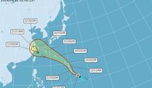
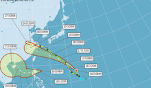
生活中心/施郁韻報導 中央氣象署指出,位於關島東南方海面上的熱帶性低氣壓,已增強為第13號輕度颱風「貝碧佳」,預計朝西北方向前進,可能在週末通過琉球群島,接近台灣,路
- 三立新聞網 setn.com • 2024年9月2日 上午 09:45
魔羯南修還是有影響!今各地飆36度高溫 明起這區雷雨轟炸
生活中心/綜合報導中央氣象署昨(1)日發布颱風生成訊息,原位於菲律賓東方海面的熱帶性低氣壓,於晚上8時發展為輕度颱風,編號第11號(國際命名:YAGI,中文譯名:摩羯);目前中央氣
- 三立新聞網 setn.com • 2024年9月12日 上午 11:15
下周「恐有雙颱發展」!賈新興揭對中秋天氣影響 各地賞月機率曝
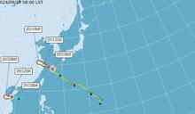
生活中心/許智超報導 中央氣象署今(12)日8時最新觀測,輕颱「貝碧佳」的中心位置在北緯17.5度,東經139.8度,以每小時21公里速度,向北北西進行。台灣整合防災
- 中天新聞網 • 2024年9月15日 晚上 06:30
連15個月平均氣溫「創175年新高」 氣象署提醒:今年可能是暖冬
近年氣溫不斷升高,氣象專家賈新興表示,今年8月的平均溫度已創175年來歷史新高,也是連續15個月全球平均氣溫月月創新高。同時,中央氣象署預測,今年「反聖嬰」可能在冬季發展,全台偏暖。
- 中天新聞網 • 2024年9月11日 凌晨 01:09
輕颱貝碧佳最新路徑揭曉 恐「5天直衝台灣北部」
今年第13號颱風「貝碧佳」(BEBINCA)10日晚間生成,中央氣象署表示,目前貝碧佳颱風位在距台2770公里海面,預測顯示可能會在5天後接近台灣北部海域,再往大陸上海方向靠近。
- 壹蘋新聞網 • 2024年9月6日 下午 01:43
貝碧佳颱風將生成?專家估這兩天有機會
【黃詩淳/綜合報導】台灣整合防災工程技術顧問公司總監賈新興今(6日)在臉書透露,觀察9日至10日菲律賓東南方外海熱帶性低氣壓或今年第13號颱風貝碧佳有發展趨勢,並表示未來10天受低壓帶影響,午後各地有局部短暫雷陣雨。
- 三立新聞網 setn.com • 2024年9月13日 上午 09:10
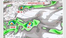
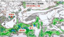
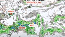
恐有雙颱!葡萄桑、蘇力最快接力生成時間曝 「這3天」影響台灣
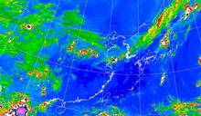
生活中心/林昀萱報導根據中央氣象署今(13)日2時觀測,今年第13號颱風貝碧佳正在鵝鑾鼻東方1740公里之海面上,以每小時30公里速度,向西北進行,預計週末將通過琉球附近海面,離台
- 三立新聞網 setn.com • 2024年9月19日 下午 01:10
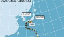
蘇力颱風生成!明起天氣極不穩定 全台連4天「雨下到發紅」
生活中心/許智超報導熱帶性低氣壓(TD18)今(19)日稍早已增強為今年第15號颱風「蘇力」,中央氣象署預估,未來路徑往西方向往中南半島前進,對台無直接影響。台灣整合防災工程技術顧
- 新頭殼 • 2024年9月11日 上午 10:59
颱風接力!「貝碧佳」對台影響曝光 賈新興:「葡萄桑」下週恐生成
[Newtalk新聞] 第13號輕度颱風「貝碧佳」昨(10)日晚間8點生成,預測向西北朝琉球前進,預計本週末接近琉球群島附近,15日再進入東海,侵襲台灣機率低。另外,台灣整合防災工程技術顧問公司總監賈新興指出,菲律賓東南方外海熱帶性低氣壓,有機會於下週一(16日)發展為第14號颱風「葡萄桑」。 賈新興提到,貝碧佳發展環境比較好,週六、週日會影響琉球群島一帶,提醒前往當地旅遊的民眾注意。而根據歐洲模式預測,14日...
- 中天新聞網 • 2024年9月10日 上午 10:29
中秋烤肉泡湯?颱風「葡萄桑」恐9/16生成 賈新興揭未來10天「降雨熱區」
「貝碧佳」颱風最快於明天(11日)生成,而下週就是中秋節,台灣整合防災工程技術顧問公司總監賈新興指出未來10天天氣重點,並提醒9/16菲律賓東南方外海熱帶低壓,恐發展成第14號颱風葡萄桑。
- 今周刊 • 2024年8月31日 晚上 07:22
颱風「摩羯」成颱機率7成!會撲台登陸嗎?專家預測3路徑:恐達強颱「這時間點」影響台灣
又有新颱風要靠近台灣?據了解,今年第11號颱風「摩羯」有機會在下週生成,氣象專家指出,生成機率高達7成,歐洲模式預測往台灣跑、有通過宜花機會;另據氣象達人吳德榮指出,根據颱風路徑顯示,可能「直接登陸台灣」。
- EBC東森新聞 • 2024年9月10日 中午 12:24
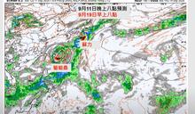
葡萄桑颱風下周一「熟成」? 未來10天雨區曝光
受大低壓環流影響,近期有多個熱帶系統可能發展,其中又以「貝碧佳」、「葡萄桑」最受各界關注。「台灣整合防災工程技術顧問公司」總監賈新興,預估葡萄桑有機會在下周一(16日)生成,並分析可能影響。 賈新興指出,第13號颱風貝碧佳最快明天生成,並於週末接近琉球群島;第14號颱風葡萄桑則有機率在16日生成,需留意後續發展及移動趨勢,從歐洲模式來看...
- 鏡週刊Mirror Media • 2024年9月16日 上午 10:49
緊隨葡萄桑之後!蘇力颱風「最快明生成」 最新路徑曝光
今年颱風生成數量頗多,雖然都沒有直接衝擊台灣,但近日除了中颱貝碧佳,還有輕颱葡萄桑。目前台灣東南方海面上,也有一熱帶性低氣壓,最快可能於明(17)日生成今年第15號颱風「蘇力」。
- CTWANT • 2024年8月20日 上午 11:08
未來10天無熱帶擾動發展 賈新興:9月中起有利颱風生成「持續至10月」
[周刊王CTWANT] 賈新興今(20日)在臉書發文指出,周五(22日)至周六(23日)降雨趨緩,轉為零星短暫雨。明(21日)清晨嘉義以南有局部短暫雨,午後北北基桃、北部山區、中投及宜花有局部短暫陣雨。22日至23日,午後北部山區、宜蘭及花東山區有局部短暫陣雨。今日起至23日,臺東地區有局部...
- CTWANT • 2024年9月15日 晚上 07:02
8月平均溫度創「175年歷史新高」 反聖嬰發展…台灣冬天偏暖
[周刊王CTWANT] 台灣整合防災工程技術顧問公司總監賈新興在臉書發文,PO出美國國家海洋暨大氣總署(NOAA)資料,指出今年8月地球平均溫度創新高,8月、6至8月、1至8月的地球平均溫度,均創下175年以來歷史新高。賈新興表示,分別比長期平均溫15.6°C、15.6°C、14.0°C,高出了1.27°C、1.24°C、...
- 華視 • 2024年9月13日 上午 09:50
颱風接力生成中!葡萄桑、蘇力最快週末形成 影響台灣時間曝
根據中央氣象署今(13)日清晨觀測,第13號輕度颱風「貝碧佳」以每小時32公里速度,向西北進行。另外,氣象專家指出,菲律賓東南方外海的季風低壓帶,有機會於15日至16日發展為雙颱,若生成則分別是「葡萄...
- TVBS新聞網 • 2024年9月16日 下午 05:25
8月熱壞「平均溫度創下新高」! 氣象署:可能冬季偏暖
天氣越來越熱了!台灣整合防災工程技術顧問公司總監賈新興指出,今(2024)年8月平均溫度創下175年以來歷史新高,已連續15個月全球平均氣溫月月創新高。
- 三立新聞網 setn.com • 2024年9月5日 下午 12:35
颱風「麗琵」下周恐發展!周末全台防午後雷雨 下最大地區曝
生活中心/許智超報導 今年第11號颱風「摩羯」已於今(5)日8時增強為強烈颱風,雖然對台灣天氣無直接影響,但部分地區仍受外圍環流影響。台灣整合防災工程技術顧問公司總監
- 中廣新聞網 • 2024年9月12日 上午 11:22
下週恐有「雙颱」生成 專家曝中秋賞月機率
台灣整合防災工程技術顧問公司總監賈新興今天(12日)表示,根據目前的資料,颱風「貝碧佳」預計將在週六至週日影響琉球群島一帶。菲律賓東南方外海的季風低壓帶,不排除在週日至下週一有可能形成雙颱,若生成將分
- 中廣新聞網 • 2024年8月31日 上午 10:16
下周恐有魔羯颱風生成 對台影響機會曝
今年第10號颱風珊珊龜速前進大鬧日本,釀成嚴重災情,死傷合計超過百人,陸空交通大亂,雖然珊珊已經在今天早上八點減弱為熱帶性氣壓,但這兩天計畫前往日本的民眾還是要小心豪雨影響行程。繼珊珊之後菲律賓東方,