<a href="/wg_8714b7f1589aa0f6c92979708057c4a57/en/es/www.meteociel.fr/"="">Accueil</a><span=""> - </span><span id="menu_nb_visiteurs"="">
6187
visiteurs </span>
|
| |
|
| • Mod�les - GFS Europe [ <a href="/wg_8714b7f1589aa0f6c92979708057c4a57/en/es/www.meteociel.fr/modeles/index.php"="">GFS 0.25° </a>] - [ <a href="/wg_8714b7f1589aa0f6c92979708057c4a57/en/es/www.meteociel.fr/modeles/ecmwf/"="">ECMWF</a> ] - [ <a href="/wg_8714b7f1589aa0f6c92979708057c4a57/en/es/www.meteociel.fr/modeles/ukmo2.php?ech=6&carte=1021"=""> UKMO Europe </a>] - [ <a href="/wg_8714b7f1589aa0f6c92979708057c4a57/en/es/www.meteociel.fr/modeles/gefs_cartes.php"=""> GEFS Ensemble </a> ] - [ <a href="/wg_8714b7f1589aa0f6c92979708057c4a57/en/es/www.meteociel.fr/modeles/geme_cartes.php"="">GEM</a> ] - [ <a href="/wg_8714b7f1589aa0f6c92979708057c4a57/en/es/www.meteociel.fr/modeles/jma.php"=""> JMA </a> ] - [ <a href="/wg_8714b7f1589aa0f6c92979708057c4a57/en/es/www.meteociel.fr/modeles/navgeme_cartes.php"=""> NAVGEM </a> ] |
Cartes du mod�le GFS Europe <a href="#" class="infobutton"=""><span class="info"="">6 Domaines :</span></a><a href="gfse_cartes.php?ech=6&code=code&mode=0&mode3h=0&runpara=0&carte=0" class="button"=""><span class="rien"="">Europe</span></a><a href="gfse_cartes.php?ech=6&code=code&mode=0&mode3h=0&runpara=0&carte=5" class="button"=""><span class="rien"="">Europe (LCC)</span></a><a href="gfse_cartes.php?ech=6&code=code&mode=0&mode3h=0&runpara=0&carte=6" class="button"=""><span class="rien"="">Eur. Ouest</span></a><a href="gfse_cartes.php?ech=6&code=code&mode=0&mode3h=0&runpara=0&carte=1" class="button"=""><span class="rien"="">Hémi. Nord</span></a><a href="gfse_cartes.php?ech=6&code=code&mode=0&mode3h=0&runpara=0&carte=2" class="button"=""><span class="rien"="">N. Amérique</span></a><a href="gfse_cartes.php?ech=6&code=code&mode=0&mode3h=0&runpara=0&carte=4" class="button"=""><span class="rien"="">Australie NZ</span></a><a href="gfse_3d.php" class="button"=""><span class="rien"="">GFS 3D Monde</span></a> |
Pr�cisions :
Ces cartes pr�sentent les donn�es du mod�le GFS 0.25°. Les cartes sont r�actualis�es rapidement en temps r�el � partir de 4h30, 10h30, 16h30 et 22h30. Les cartes d'�ch�ance de 6h en 6h sont archiv�es depuis F�vrier 2007.
|
|
|
|
|


 6h
6h 90h
90h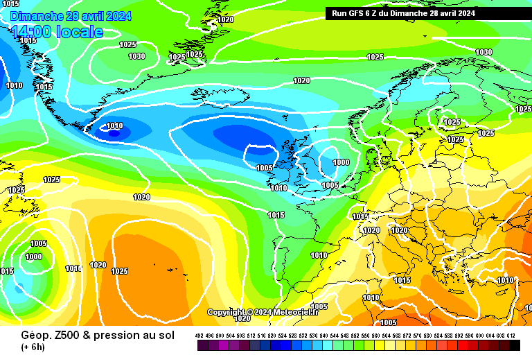
 Run 6h
  Run 12h
  Vieux run de plus de 24h