Category:Flat River, Michigan, taken by Lar: Difference between revisions
Jump to navigation
Jump to search
Content deleted Content added
set up category |
|||
| (4 intermediate revisions by 3 users not shown) | |||
| Line 1: | Line 1: | ||
;Mouth: <!-- Google Maps link: http://www.google.com/maps?hl=en&q=&ie=UTF8&om=1&z=17&ll=42.927771,-85.338653&spn=0.00601,0.007961 --> |
;Mouth ([[w:Lowell, Michigan|Lowell]]) : <!-- Google Maps link: http://www.google.com/maps?hl=en&q=&ie=UTF8&om=1&z=17&ll=42.927771,-85.338653&spn=0.00601,0.007961 --> |
||
{{ |
{{Object location|42.927771|-85.338653}} |
||
;Headwaters (approximate location near [[w:Six Lakes, Michigan|Six Lakes]] and the [[w:Edmore State Game Area|Edmore State Game Area]]) <!-- Google Maps link: http://maps.google.com/maps?ll=43.43971,-85.10190&spn=0.011168,0.015411&hl=en --> |
|||
;Headwaters (approximate): |
|||
{{ |
{{Object location|43.43971|-85.10190}} |
||
The '''[[w:Flat River, (Michigan)|Flat River]]''' is a tributary of the [[w:Grand River, Michigan|Grand River]] in western Michigan |
The '''[[w:Flat River, (Michigan)|Flat River]]''' is a tributary of the [[w:Grand River, Michigan|Grand River]] in western Michigan |
||
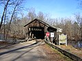
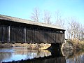
that runs through [[w:Montcalm County, Michigan|Montcalm County]], [[w:Ionia County, Michigan|Ionia County]], and [[w:Kent County, Michigan|Kent County]], flowing into the Grand at [[w:Lowell, Michigan|Lowell]]. Two historic [[w:covered bridge|covered bridge]]s cross the river. One, the [[w:Fallasburg Bridge|Fallasburg Bridge]], in [[w:Vergennes Township, Michigan|Vergennes Township]], Kent County |
that runs through [[w:Montcalm County, Michigan|Montcalm County]], [[w:Ionia County, Michigan|Ionia County]], and [[w:Kent County, Michigan|Kent County]], flowing into the Grand at [[w:Lowell, Michigan|Lowell]]. Two historic [[w:covered bridge|covered bridge]]s cross the river. One, the [[w:Fallasburg Bridge|Fallasburg Bridge]], is in [[w:Vergennes Township, Michigan|Vergennes Township]], Kent County within the Fallasburg County Park a few miles north of Lowell. The other, [[w:Whites Bridge|Whites Bridge]] is a few miles to the northeast in adjacent northwest [[w:Keene Township, Michigan|Keene Township]], Ionia County, near [[w:Smyrna, Michigan|Smyrna]]. Both bridges are on small county roads. |
||
These pics were taken by [[User:Lar]], contact him for more info... |
These pics were taken by [[User:Lar]], contact him for more info... |
||
{{user category|cat=Taken by Lar}} |
|||
[[Category:Flat River, Michigan]] |
|||
Latest revision as of 16:56, 25 October 2016
- Mouth (Lowell)
| Object location | | View all coordinates using: OpenStreetMap |
|---|
- Headwaters (approximate location near Six Lakes and the Edmore State Game Area)
| Object location | | View all coordinates using: OpenStreetMap |
|---|
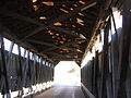
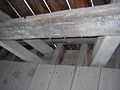
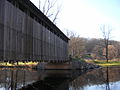
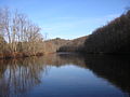
The Flat River is a tributary of the Grand River in western Michigan that runs through Montcalm County, Ionia County, and Kent County, flowing into the Grand at Lowell. Two historic covered bridges cross the river. One, the Fallasburg Bridge, is in Vergennes Township, Kent County within the Fallasburg County Park a few miles north of Lowell. The other, Whites Bridge is a few miles to the northeast in adjacent northwest Keene Township, Ionia County, near Smyrna. Both bridges are on small county roads.
These pics were taken by User:Lar, contact him for more info...
Media in category "Flat River, Michigan, taken by Lar"
The following 17 files are in this category, out of 17 total.
-
 FallasburgBridge HistoricalMarker DSCN9990.JPG 1,200 × 1,600; 394 KB
-
 FallasburgBridge Interior DSCN9994.JPG 1,600 × 1,200; 351 KB
-
 FallasburgBridge InteriorFloorDetailDSCN9995.JPG 1,600 × 1,200; 377 KB
-
 FallasburgBridge InteriorSnowProtectionDSCN9996.JPG 1,200 × 1,600; 338 KB
-
 FallasburgBridge Overall Downstream DSCN9977.JPG 1,600 × 1,200; 399 KB
-
 FallasburgBridge Overall DownstreamApproachDSCN9984.JPG 1,600 × 1,200; 417 KB
-
 FallasburgBridge UndersideDSCN0007.JPG 1,600 × 1,200; 358 KB
-
 FallasburgBridge VehicleCrossingDSCN0016.JPG 1,600 × 1,200; 407 KB
-
 FallasburgBridge WestPortal DSCN9987.JPG 1,600 × 1,200; 429 KB
-
 WhitesBridge FlatRiver FloorTrussDetail DSCN9961.JPG 1,600 × 1,200; 378 KB
-
 WhitesBridge FlatRiver InteriorTrussDetail DSCN9947.JPG 1,600 × 1,200; 438 KB
-
 WhitesBridge FlatRiver Marker Dscn9971crop.jpg 750 × 1,000; 488 KB
-
 WhitesBridge FlatRiver Scene DSCN9933.JPG 1,600 × 1,200; 359 KB
-
 WhitesBridge FlatRiver SouthEnd DSCN9928.JPG 1,600 × 1,200; 420 KB
-
 WhitesBridge FlatRiver Upstream WholeBridge DSCN9939.JPG 1,600 × 1,200; 436 KB
-
 WhitesBridge FlatRiver UpstreamNorthEnd DSCN9934.JPG 1,600 × 1,200; 380 KB
-
 WhitesBridge FlatRiver UpstreamTruss Dscn9935crop.jpg 1,350 × 960; 835 KB


