Hawaii Volcanoes National Park: Difference between revisions
Jump to navigation
Jump to search
Content deleted Content added
→Eruptions and active lava flows: Added photo Tags: Mobile edit Mobile web edit Advanced mobile edit |
m →Photos: rm broken zoom template |
||
| Line 8: | Line 8: | ||
==Photos== |
==Photos== |
||
<gallery mode="packed" widths=140px heights=140px> |
<gallery mode="packed" widths=140px heights=140px> |
||
File:Hawaii lava field 360.jpg|360° panoramic view of Hawai{{okina}}i lava field |
File:Hawaii lava field 360.jpg|360° panoramic view of Hawai{{okina}}i lava field |
||
File:Kalapana May 2009.jpg|{{FP star}} The town of Kalapana was destroyed by a lava flow |
File:Kalapana May 2009.jpg|{{FP star}} The town of Kalapana was destroyed by a lava flow |
||
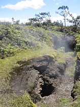
File:Thurston Lava Tube, Big Island.jpg|{{FP star}} Thurston Lava Tube |
File:Thurston Lava Tube, Big Island.jpg|{{FP star}} Thurston Lava Tube |
||
Revision as of 21:45, 22 October 2023
English: - Hawaiʻi Volcanoes National Park, established in 1916, displays the results of 70 million years of volcanism, migration, and evolution—processes that thrust a bare land from the sea and clothed it with complex and unique ecosystems and a distinct human culture.
Deutsch: - Auf der größten Insel von Hawaii, im gleichnamigen Bundesstaat der USA gelegen, befindet sich im Hawaii Volcanoes Nationalpark der aktivste Vulkan der Welt, der Kilauea. Der Park reicht von der Pazifik-Küste bis zum größtem Vulkan, dem 4.169 Meter hohen Mauna Loa und umfasst ein komplexes und einzigartiges Ökosystem. Das Ergebnis von 70 Millionen Jahren Vulkanismus, Migration und Evolution kann im Park beobachtet werden.
日本語: - ハワイ火山国立公園(―かざんこくりつこうえん、Hawaii Volcanoes National Park)は、アメリカ合衆国ハワイ州ハワイ島の南に広がる火山地帯を中心とした国立公園。
Photos
-
 360° panoramic view of Hawaiʻi lava field
 -

 The town of Kalapana was destroyed by a lava flow
 -
 Thurston Lava Tube
 -
 Offerings of fruit at a crater rim (of Mauna Loa) on the Big Island of Hawaii
 -
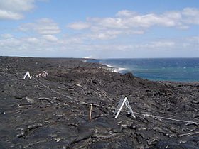 Walking across the lava flow, Big Island of Hawaii
 -
 An ironic sign warning of danger
 -
 Jaggar Museum
 -
 Kilauea Military Camp office as it appeared in 1959
 -
 Old lava flows covering roads
 -
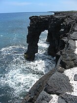 Sea arch of lava
 -
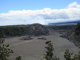 Kilauea Iki vent, which erupted in 1959, contains a solidified lava lake.
 -
 The 300 foot wide and 500 foot deep Pauahi Crater along the Chain of Craters Road.
 -
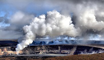
 Steam plumes along the Halema'uma'u Crater rim
 -
 At Sulphur Banks, volcanic gases seep directly from the ground
 -

-


.jpg)
.jpg)
Eruptions and active lava flows
-
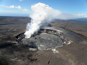
 Sulfur-rich steam at the Halemaumau vent
 -
 Lava erupting from the Pu`u `O`o vent
 -
 Arching lava fountain about 10 m high, south of Pu‘u Kahaualea
 -
 Slow moving lava can be approached quite closely
 -
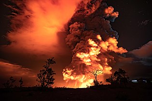
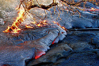 Tree on fire in active lava flow
 -
 Steam from active lava tubes along the Chain of Craters Road.
 -
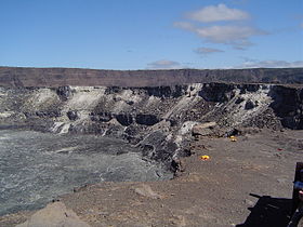
 Halema'uma'u Crater is one of two active vents of the Kilauea volcano.
 -
 Pahoehoe flow
 -
 A'a flow
 -
 Kilauea
 -
 Kilauea


Satellite imagery
-
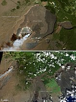 Kilauea
 -
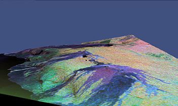 3D radar (false color) image of Kilauea


Maps and diagrams
-
 Location of Hawaii Volcanoes National Park
 -
 Map of National Park Service facilities on island of Hawaii
 -
 NPS facilities on true-color map
 -
 Diagram of hotspot


