Hawaii Volcanoes National Park: Difference between revisions
Jump to navigation
Jump to search
Content deleted Content added
→Photos: transwiki from en |
→Photos: drop unfree image |
||
| Line 27: | Line 27: | ||
File:Kilauea Military Camp Office, 1959.JPG|Kilauea Military Camp office as it appeared in 1959 |
File:Kilauea Military Camp Office, 1959.JPG|Kilauea Military Camp office as it appeared in 1959 |
||
File:'Pele' by D. Howard Hitchcock, c. 1929.jpg|Hitchcock's [[:en:Pele (deity)|Pele]], c. 1929 |
File:'Pele' by D. Howard Hitchcock, c. 1929.jpg|Hitchcock's [[:en:Pele (deity)|Pele]], c. 1929 |
||
File:The goddess pele by arthur johnsen.jpg|Arthur Johnsen's [[:en:Pele (deity)|Pele]] |
|||
File:HawaiiLavaNoRoad.jpg|Old lava flows covering roads |
File:HawaiiLavaNoRoad.jpg|Old lava flows covering roads |
||
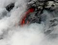
File:LavaInMotion.jpg|Slow moving lava can be approached quite closely |
File:LavaInMotion.jpg|Slow moving lava can be approached quite closely |
||
Revision as of 01:10, 16 March 2013
English: - Hawai‘i Volcanoes National Park, established in 1916, displays the results of 70 million years of volcanism, migration, and evolution—processes that thrust a bare land from the sea and clothed it with complex and unique ecosystems and a distinct human culture.
Deutsch: - Auf der größten Insel von Hawaii, im gleichnamigen Bundesstaat der USA gelegen, befindet sich im Hawaii Volcanoes Nationalpark der aktivste Vulkan der Welt, der Kilauea. Der Park reicht von der Pazifik-Küste bis zum größtem Vulkan, dem 4.169 Meter hohen Mauna Loa und umfasst ein komplexes und einzigartiges Ökosystem. Das Ergebnis von 70 Millionen Jahren Vulkanismus, Migration und Evolution kann im Park beobachtet werden.
日本語: - ハワイ火山国立公園(―かざんこくりつこうえん、Hawaii Volcanoes National Park)は、アメリカ合衆国ハワイ州ハワイ島の南に広がる火山地帯を中心とした国立公園。
Maps
-
 Location of Hawaii Volcanoes National Park
 -
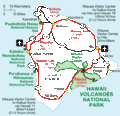 Map of National Park Service facilities on island of Hawaii


Photos
-
 Offerings of fruit at a crater rim (of Mauna Loa) on the Big Island of Hawaii
 -
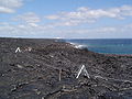 Walking across the lava flow, Big Island of Hawaii
 -
 Walking across the lava flow, Big Island of Hawaii
 -
 Lava erupting from the Pu`u `O`o vent
 -

-

-
 Thurston Lava Tube
 -
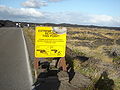 An ironic sign warning of danger
 -
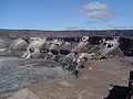
 Jaggar Museum
 -
 Kilauea Military Camp office as it appeared in 1959
 -
Hitchcock's Pele, c. 1929
-
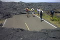 Old lava flows covering roads
 -
 Slow moving lava can be approached quite closely
 -
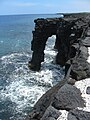 Sea arch of lava, caused by erosive wave action, near the flowing lava site.
 -
 Pāhoehoe Lava is entering Pacific


Satellite imagery
-
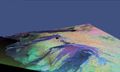 3D radar (false color) image of Kilauea
