Space Radar Map
 The northern end of the island country of Taiwan, including the capital city of Taipei, is shown in this spaceborne radar image. The northern end of the island country of Taiwan, including the capital city of Taipei, is shown in this spaceborne radar image.
|
 Space Radar Map by NASA/ STS068-239-090/ Taipei Area, Taiwan/ October 1994. Space Radar Map by NASA/ STS068-239-090/ Taipei Area, Taiwan/ October 1994.
|
Historical Photo
 Drawing about the Moment Japanese Soldiers Entering Taipei City in 1895 after the Treaty of Shimonoseki between Qing and Japan Drawing about the Moment Japanese Soldiers Entering Taipei City in 1895 after the Treaty of Shimonoseki between Qing and Japan
|
 Taipei Broadcasting Station, taken prior to 1931 Taipei Broadcasting Station, taken prior to 1931
|
 Six-House Street, Dadaocheng District, Taipei City, later half of 19 century Six-House Street, Dadaocheng District, Taipei City, later half of 19 century
|
| File:Dadaocheng Public School.jpgDadaocheng Public School, built in 1898, located in Dadaocheng, Taipei, Taiwan/ Date Unknown
|
File:Dadaocheng German Consulate.jpgGerman Consulate, located in Dadaocheng District, Taipei City/ Date Unknown
|
Painting from Japanese Era (1895-1945)
 Building of Taiwan-Governor-in-General/ Shichuan Qiyilang/ 1916/ Watercolor/ 33.2 x 24.5 cm/ Collection from Taipei Museum of Fine Art Building of Taiwan-Governor-in-General/ Shichuan Qiyilang/ 1916/ Watercolor/ 33.2 x 24.5 cm/ Collection from Taipei Museum of Fine Art
|
 Seen from Taipei New Park/ Xiaoshan Bulao/ 1931/ Selected by the Fifth Exhibition of Taiwan-Government-in-General Seen from Taipei New Park/ Xiaoshan Bulao/ 1931/ Selected by the Fifth Exhibition of Taiwan-Government-in-General
|
Contemporary Photo
| File:Taipeh101.jpgTaipei 101, the highest building in the world now, is located in Taipei, Taiwan
|
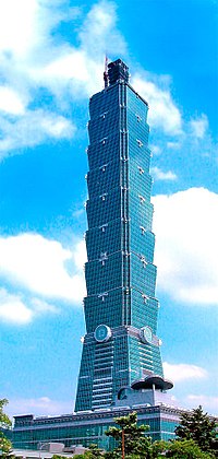 Taipei 101, the highest building in the world now, is located in Taipei, Taiwan Taipei 101, the highest building in the world now, is located in Taipei, Taiwan
|
 Taipei Main Station/ Took in July 2004 Taipei Main Station/ Took in July 2004
|
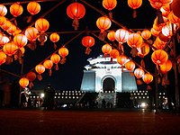 The Chiang Kai-shek memorial hall at night during the lantern festival The Chiang Kai-shek memorial hall at night during the lantern festival
|
 National Palace Museum, Taipei, Taiwan/ Picture taken by Allen Timothy Chang in December 2000 National Palace Museum, Taipei, Taiwan/ Picture taken by Allen Timothy Chang in December 2000
|
Longshan Temple (Wanhua/Mengjia, Taipei)
 Longshan Temple in Wanhua (萬華) or Mengjia (艋舺), Taipei/ Took in August, 2003 Longshan Temple in Wanhua (萬華) or Mengjia (艋舺), Taipei/ Took in August, 2003
|
 Lungshan Temple, Wanhua District, Taipei City, Taiwan; Taken by Allen Timothy Chang in January 2003 Lungshan Temple, Wanhua District, Taipei City, Taiwan; Taken by Allen Timothy Chang in January 2003
|


.jpg)


