Category:T and O map
Aller à la navigation
Aller à la recherche
représentation du monde connu au Moyen Âge  | |||||
| Téléverser des médias | |||||
| Nature de l’élément | |||||
|---|---|---|---|---|---|
| Sous-classe de | |||||
| |||||
Deutsch: Die Radkarte, eine mittelalterliche Form der Darstellung der damals bekannten Erde.
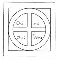
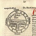
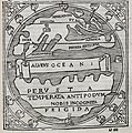
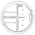
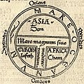
English: A T and O map oder T-O map, is a type of medieval world map. It represents the physical world as described by the 7th century scholar Isidore of Seville in his Etymologiae (chapter 14, de terra et partibus):
- Orbis a rotunditate circuli dictus, quia sicut rota est [...] Undique enim Oceanus circumfluens eius in circulo ambit fines. Divisus est autem trifarie: e quibus una pars Asia, altera Europa, tertia Africa nuncupatur.
- "The [inhabitated] mass of solid land is called 'round' after the roundness of a circle, because it is like a wheel [...] Because of this, the Ocean flowing around it is contained in a circular limit, and it is divided in three parts, one part being called Asia, the second Europe, and the third Africa."
Isidore does not assume a flat earth, shaped "like a wheel", he assumes a round earth in correspondence to the theory of the spherical earth that had been the mainstream assumption at least since Aristotle.
The T and O map represents the top-half of the globe, it was thought that no one had ever been to the ‚other‘ half, the antipodes, where some thought people known as antipodeans lived. The T consists of the Mediterranean, the Russian Don River and the Nile, dividing the three continents, Asia, Europa and Africa, and the O is the encircling Ocean. Jerusalem was generally assumed to lie at the center of the circle. Asia was typically the size of the other two continents combined. Because the sun rose in the east, Paradise (the Garden of Eden) was generally depicted as being in the outmost of Asia, situated at the top portion of the map.Español: Mapa de T en O, o mapa Orbis Terrarum, es un tipo de mapamundi elaborado en la Edad Media y caracterizado por su alta carga teológica. El primero en realizar estos mapamundis fue Isidoro de Sevilla.
Sous-catégories
Cette catégorie comprend 6 sous-catégories, dont les 6 ci-dessous.
A
B
H
- Hereford Mappa Mundi (1 P, 37 F)
L
- La Mer des Histoires (7 F)
P
- Psalter world map London (14 F)
Média dans la catégorie « T and O map »
Cette catégorie comprend 59 fichiers, dont les 59 ci-dessous.
-
 Diagrammatic T-O map - Etymologies (early 13th C), f.99v - BL Add MS 22797.jpg 1 479 × 1 645 ; 957 kio
-
 139 of 'Le Continent austral. Hypothèses et découvertes' (11128923226).jpg 953 × 951 ; 133 kio
-
 1475 Rudimentum Novitorum Lucas brandis.jpg 2 500 × 2 221 ; 3,45 Mio
-

-
-
 RAINAUD(1893) Fig. 6. Type de rouelle.jpg 835 × 881 ; 205 kio
-
 32 of 'The International Geography. ... Edited by H. R. Mill' (11164778283).jpg 850 × 852 ; 181 kio
-
 Bergomensis T-O World Map 1503 Cornell CUL PJM 1003 01.jpg 5 144 × 7 059 ; 4,92 Mio
-
 Bodleian Libraries, Basic TO map 60.jpg 672 × 1 000 ; 165 kio
-
 Bodleian Libraries, Basic TO map 64.jpg 672 × 1 000 ; 151 kio
-
 Bodleian Libraries, Basic TO map and a schematic map.jpg 672 × 1 000 ; 171 kio
-
 Bodleian Libraries, Basic TO map and a slightly more elaborate TO map.jpg 1 000 × 675 ; 136 kio
-
 Bodleian Libraries, Basic TO map.jpg 672 × 1 000 ; 140 kio
-
 Bodleian Libraries, Elaborate TO map.jpg 672 × 1 000 ; 162 kio
-
 Bodleian Libraries, Mappa Mundi and text.jpg 687 × 1 000 ; 116 kio
-
 Bodleian Libraries, The three continents.jpg 1 000 × 675 ; 133 kio
-
 Ca. 1505 T and O map by Zacharias Lilius (cropped).jpg 2 791 × 3 924 ; 822 kio
-
 Ca. 1505 T and O map by Zacharias Lilius.jpg 6 084 × 4 309 ; 2,38 Mio
-
 CamposantoPisa Cosmographia detalle mapamundi.jpg 2 448 × 3 264 ; 1,18 Mio
-
 Cava de' Tirreni, Biblioteca dell'Abbazia, cod. 3, fol. 216v.jpg 2 929 × 3 000 ; 1,24 Mio
-
 Das Weltkärtchen von Strassburg, 9. Jahrhundert.jpg 836 × 930 ; 273 kio
-
 Democratic Ideals and Reality, 1919 Fig 21 p 115.jpg 530 × 560 ; 40 kio
-
 Diagrammatic T-O world map - 12th c.jpg 608 × 608 ; 72 kio
-
 Diagrammatic T-O world map - 12th century.jpg 608 × 767 ; 93 kio
-
 EB 1911 Map Fig 9.png 1 950 × 1 572 ; 648 kio
-
 EB 1911 Map Fig 10.png 1 368 × 1 396 ; 948 kio
-
 Etimologías - Mapa del Mundo Conocido.jpg 1 197 × 1 191 ; 487 kio
-
 Etymologiae Guntherus Ziner 1472.jpg 640 × 939 ; 124 kio
-
 Ibn Howqal World map ُ edited.jpg 460 × 473 ; 147 kio
-
 Liber Floridus 1120 Peuples p42.png 504 × 596 ; 608 kio
-
 Macrobius' map of the world.jpg 1 673 × 1 706 ; 655 kio
-
 Macrobius' world map (cropped).jpg 1 830 × 1 841 ; 837 kio
-
 Macrobius' world map.jpg 6 000 × 4 031 ; 4,65 Mio
-
 Mapa T en O de un manuscrito del s IX de las Etimologías Vitr14-3 f116v.jpeg 902 × 880 ; 567 kio
-
 Mapamundi (c. 990) del Códice de Roda, f. 200v.jpg 1 625 × 2 266 ; 2,69 Mio
-
 Mappemonde terrestre - verso du Saint Florian.jpg 3 054 × 4 516 ; 2,09 Mio
-
 Meyers b5 s0756 b1.png 371 × 375 ; 21 kio
-

-
 Actual orthographic T&O.png 2 800 × 2 480 ; 1,37 Mio
-
 Orthographic T&O.png 1 806 × 1 806 ; 863 kio
-
 Psalter World Map, c.1265.jpg 3 791 × 5 496 ; 19,47 Mio
-
 Radkarte MKL1888 edited (T and O style, east-up).png 357 × 355 ; 13 kio
-
 Radkarte MKL1888.png 355 × 357 ; 13 kio
-
 St Johns MS 17 folio 6r.jpg 629 × 489 ; 112 kio
-
 T and O map Guntherus Ziner 1472 bw.jpg 864 × 864 ; 350 kio
-
 T and O map Guntherus Ziner 1472.jpg 864 × 864 ; 279 kio
-
 T-and-O map symbol (inverted).svg 16 × 16 ; 365 octet
-
 T-and-O map symbol (north up).svg 16 × 16 ; 338 octet
-
 T-and-O map symbol.svg 16 × 16 ; 364 octet
-
 T-O Mappa mundi z.jpg 519 × 663 ; 263 kio
-
 T-O Mappa mundi.jpg 600 × 819 ; 122 kio
-
 Tariq and roderic.jpg 640 × 429 ; 74 kio
-
 TO map.gif 815 × 803 ; 24 kio
-
 Vitriol symbol.svg 16 × 16 ; 304 octet
-
 Western Manuscript 372 Etymologies. Wellcome L0024508.jpg 4 110 × 4 198 ; 6,66 Mio
-
 World map published in Somnium Scipionis exposito (cropped).jpg 2 025 × 2 029 ; 651 kio
-
 World map published in Somnium Scipionis exposito.jpg 5 888 × 4 050 ; 3,54 Mio
-

-
 Річка сивол середньовічча.gif 80 × 79 ; 948 octet
,_f.99v_-_BL_Add_MS_22797.jpg)
.jpg)

_vol._1%27_(11245718506).jpg)
_Fig._5._La_terre_divis%C3%A9e_en_quatre_quartiers_d%27apr%C3%A8s_un_mss._de_l%27Image_du_Monde_de_la_Bibl.jpg)
_Fig._6._Type_de_rouelle.jpg)
.jpg)


.jpg)


.jpg)


_del_C%C3%B3dice_de_Roda,_f._200v.jpg)


,_Isidore-Codex_236.png)


.png)


.svg)
.svg)


.jpg)

