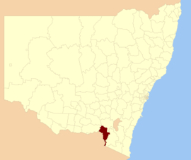
Tumbarumba Shire is a local government area in New South Wales, Australia in the foothills of the Snowy Mountains, on the upper reaches of the Murray River. It includes the town of Tumbarumba and the small towns of Rosewood, Tooma, Khancoban and Jingellic.
| Tumbarumba Shire New South Wales | |||||||||||||||
|---|---|---|---|---|---|---|---|---|---|---|---|---|---|---|---|
 Location in New South Wales | |||||||||||||||
| Population | 3,735(2009)[1] | ||||||||||||||
| • Density | 0.85041/km2 (2.2026/sq mi) | ||||||||||||||
| Area | 4,392 km2 (1,695.8 sq mi)[2] | ||||||||||||||
| Mayor | Ian Chaffey | ||||||||||||||
| Council seat | Tumbarumba (Cnr Bridge and Winton Street)[2] | ||||||||||||||
| Region | Riverina | ||||||||||||||
| State electorate(s) | Albury | ||||||||||||||
| Federal division(s) | Division of Riverina | ||||||||||||||
| Website | Tumbarumba Shire | ||||||||||||||
| |||||||||||||||
Council
Tumbarumba Shire Council is composed of eight councillors elected proportionally. The mayor is not directly elected.[3] The current makeup of the council is as follows:[3]
| Party | Councillors | |
|---|---|---|
| Template:Australian politics/party colours/Independent| | Independents and Unaffiliated | 8 |
| Total | 8 | |
The current council, elected in 2008, is:[3]
| Councillor | Party | Notes | |
|---|---|---|---|
| Template:Australian politics/party colours/Independent| | Ian Chaffey | Unaffiliated | Mayor |
| Template:Australian politics/party colours/Independent| | Rodney Shaw | Unaffiliated | |
| Template:Australian politics/party colours/Independent| | George Martin | Unaffiliated | Deputy Mayor |
| Template:Australian politics/party colours/Independent| | Tony a'Beckett | Unaffiliated | |
| Template:Australian politics/party colours/Independent| | Sue Fletcher | Unaffiliated | |
| Template:Australian politics/party colours/Independent| | Brent Livermore | Independent | |
| Template:Australian politics/party colours/Independent| | Alan Becke | Independent | |
| Template:Australian politics/party colours/Independent| | Ron Blyton | Independent | |
References
- ^ Australian Bureau of Statistics (30 March 2010). "Regional Population Growth, Australia, 2008–09". Retrieved 3 June 2010.
- ^ a b "Tumbarumba Shire Council". Department of Local Government. Retrieved 2006-11-08.
- ^ a b c "Tumbarumba Shire Council". 2008 Election results. Electoral Commission NSW. Retrieved 2009-08-03. [dead link]
35°45′S 148°00′E / 35.750°S 148.000°E