The Rainbow Range, formerly known as the Rainbow Mountains,[1] is a mountain range in British Columbia, Canada, located 40 kilometres (25 mi) northwest of Anahim Lake. Named Tsitsutl, which now is the name of its highest peak and meaning "rainbow mountains" in the Ulkatcho dialect of the Carrier language,[2] is on the western edge of the Chilcotin Plateau, adjoining the Pacific Ranges of the Coast Mountains to the south, and the Kitimat Ranges of the Coast Mountains to the north. In some classification systems it is considered part of the Coast Mountains and has been assigned here in Wikipedia to the Pacific Ranges although it is not formally part of that range-complex.
| Rainbow Range | |
|---|---|
| Rainbow Mountains | |
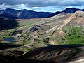
 Rainbow Range colours from heavy mineralization | |
| Highest point | |
| Peak | Tsitsutl Peak |
| Elevation | 2,495 m (8,186 ft) |
| Geography | |
| Land | Kanada |
| Province | British Columbia |
| District | Range 3 Coast Land District |
| Parent range | Chilcotin Plateau |
| Borders on | Pacific Ranges, Kitimat Ranges |
| Geology | |
| Orogeny | Anahim hotspot volcanism |
| Age of rock | 8 million years (Miocene) |
| Type of rock | Shield volcano |
It lies north of the Bella Coola and Atnarko Rivers and south and west of the Dean River, which curves around its north flank, and is relatively drier in climate and easier of terrain than more mountainous areas immediately west.
Geology
The Rainbow Range is an eight-million-year-old (Miocene) massive peralkaline shield volcano in the Anahim Volcanic Belt which includes the lower but similar Itcha and Ilgachuz Ranges. The shield has a diameter of 30 km (19 mi) is now heavily eroded by glaciers carving into the volcanic rock and sands over millions of years. The volcanism that created the shield is not well studied and is poorly understood. It is thought to be the result of the North American Plate passing over a hotspot, similar to the one feeding the Hawaiian Islands, known as the Anahim hotspot. The only real separate volcanic peak associated with the Rainbow Range is Anahim Peak which sits on its northeast flank. Other peaks in the range are other high eroded remnants of the shield, including Beef Peak, TaiaTaeszi Peak, Mount MacKenzie and Tsitsutl Peak 2,495 m (8,186 ft), which is the highest summit of the Rainbow Range.
The range gets its name from the intense and varied colours of its terrains' volcanic lavas and sands from heavy mineralization, like the Spectrum Range in the Spatsizi Plateau.
Tweedsmuir South Provincial Park
The Rainbow Range lies partly in the Tweedsmuir South Provincial Park, while to its east the Itcha and Ilgachuz Ranges form the core of the Itcha Ilgachuz Provincial Park.
See also
References
-
 Rainbow Range colours and volcanic cinder
 -
 Slopes of the Rainbow Range

