Saranac River is an 81-mile-long (130 km)[2] river in the U.S. state of New York. In its upper reaches is a region of mostly flat water and lakes. The river has more than three dozen source lakes and ponds north of Upper Saranac Lake; the highest is Mountain Pond on Long Pond Mountain. In the last third of its length it drops two-thirds of its total drop, and is known for having navigable rapids, which make it a popular site for whitewater kayaking and canoeing.
| Saranac Riviere Serindac | |
|---|---|
 | |
| Etymology | from Abenaki, "staghorn sumac cone river."[1] |
| Standort | |
| Land | Vereinigte Staaten |
| State | New York |
| Region | Adirondack Mountains |
| County | Clinton County, Essex County, Franklin County |
| Physical characteristics | |
| Source | Upper Saranac Lake |
| • coordinates | 44°15′53″N 74°14′36″W / 44.26472°N 74.24333°W |
| Mouth | Lake Champlain |
• location | City of Plattsburgh |
• coordinates | 44°41′59″N 73°26′45″W / 44.69972°N 73.44583°W |
• elevation | 95 ft (29 m) |
The Saranac River empties into Lake Champlain at the City of Plattsburgh in Clinton County, New York. The river flows in a northeasterly direction from the Adirondack Mountains.
The river encompasses Upper, Middle and Lower Saranac Lakes, as well as Oseetah Lake, Lake Flower, Franklin Falls Pond and Union Falls Pond, and flows through the village of Saranac Lake; there are locks between Middle and Lower Saranac Lakes and between Lower Saranac and Oseetah, although the drop is only a few feet. Thirty-three miles further northeast, the river flows through the Town of Saranac, before winding through Plattsburgh, reaching Lake Champlain after a further 23 miles.
The Saranac River has a fairly diverse fishery, including northern pike, largemouth bass, smallmouth bass, rock bass, pumpkinseed, fallfish, brown bullhead, brown trout, and landlocked atlantic salmon.
The river is also part of the 740-mile Northern Forest Canoe Trail, which begins in Old Forge, NY and ends in Fort Kent, ME.
Origin of Name
The name of the river is from the Abenaki word zalônák:tégw, composed of the free noun root zalôn, meaning "staghorn sumac cone"; -ak, the Abenaki plural suffix for nouns of the animate noun class; and the bound noun root (i.e., suffix) -tégw, meaning "river."[3]
-
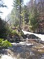 Franklin Falls in the Spring
 -
 A small island in Middle Saranac Lake, Stony Creek Mountain behind
 -
 The river passes through Saranac Lake


References
Jamieson, Paul and Morris, Donald, Adirondack Canoe Waters, North Flow, Lake George, NY: Adirondack Mountain Club, 1987. ISBN 0-935272-43-7.
Day, Gordon M. "Abenaki Place Names in the Champlain Valley." In Foster, Michael K. and Cowan, William, eds., In Search of New England's Native Past: Selected Essays by Gordon M. Day, pp. 229-262, Amherst, MA: University of Massachusetts Press, 1998. ISBN 1-558491-50-3.
See also
References
- ^ Day, pp. 248-249.
- ^ "The National Map". U.S. Geological Survey. Retrieved Feb 11, 2011.
- ^ Day, pp. 248-249.