Karimala Gopuram: Difference between revisions
Appearance
Content deleted Content added
No edit summary |
Removing geodata: {{coord missing|Kerala}} |
||
| (10 intermediate revisions by 9 users not shown) | |||
| Line 1: | Line 1: | ||
{{short description|Mountain peak in Kerala, India}} |
|||
[[File:Karimala Gopuram.jpg|thumb|Karimala Gopuram]] |
|||
{{Use dmy dates|date=July 2019}} |
|||
| ⚫ | '''Karimala Gopuram''' ('''കരിമല ഗോപുരം |
||
{{Use Indian English|date=July 2019}} |
|||
{{unreferenced|date=September 2017}} |
|||
{{Infobox mountain |
|||
| name = Karimala Gopuram <br> കരിമല ഗോപുരം |
|||
| photo = Karimala Gopuram.jpg |
|||
| photo_caption = View of Karimala Gopuram |
|||
| elevation_m = 1439 |
|||
| elevation_ref = |
|||
| prominence_m = |
|||
| prominence_ref= |
|||
| listing = [[List of highest point in Kerala by districts]] |
|||
| translation = |
|||
| language = |
|||
| location = Border of [[Chalakudy]] taluk, [[Thrissur district]] and [[Chittur]] taluk, [[Palakkad district]], [[Kerala]], [[India]] |
|||
| range = [[Western Ghats]] |
|||
| map = Kerala |
|||
| range_coordinates = |
|||
| map_caption = Location in Kerala |
|||
| coordinates = {{coord|10|21|58.47|N|76|44|48.43|E|type:mountain_region:IN_scale:100000|format=dms|display=inline,title}} |
|||
| coordinates_ref = |
|||
| topo = |
|||
| type = |
|||
| age = |
|||
| first_ascent = |
|||
| easiest_route = |
|||
}} |
|||
| ⚫ | '''Karimala Gopuram''' ('''കരിമല ഗോപുരം''') is the highest peak in the [[Thrissur district]] of [[Kerala]]. It is located at southern boundary of [[Parambikulam Wildlife Sanctuary]]. It lies in the border of [[Chalakudy taluk]] of Thrissur district and [[Chittur]] taluk of [[Palakkad district]] of Kerala. It is about 1,439m above sea level in the [[Western Ghats]]. |
||
{{coord missing|Kerala}} |
|||
[[Category:Mountains of Kerala]] |
[[Category:Mountains of Kerala]] |
||
| Line 8: | Line 34: | ||
{{Thrissur-geo-stub}} |
{{Thrissur-geo-stub}} |
||
{{Asia-mountain-stub}} |
|||
Latest revision as of 12:14, 22 October 2021
| Karimala Gopuram കരിമല ഗോപുരം | |
|---|---|
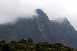
 View of Karimala Gopuram | |
| Highest point | |
| Elevation | 1,439 m (4,721 ft) |
| Listing | List of highest point in Kerala by districts |
| Coordinates | 10°21′58.47″N 76°44′48.43″E / 10.3662417°N 76.7467861°E |
| Geography | |
| Standort | Border of Chalakudy taluk, Thrissur district and Chittur taluk, Palakkad district, Kerala, India |
| Parent range | Western Ghats |
Karimala Gopuram (കരിമല ഗോപുരം) is the highest peak in the Thrissur district of Kerala. It is located at southern boundary of Parambikulam Wildlife Sanctuary. It lies in the border of Chalakudy taluk of Thrissur district and Chittur taluk of Palakkad district of Kerala. It is about 1,439m above sea level in the Western Ghats.

