Onslow Bay: Difference between revisions
Appearance
Content deleted Content added
m add/change/refine category; MOS fixes; all included cat using AWB |
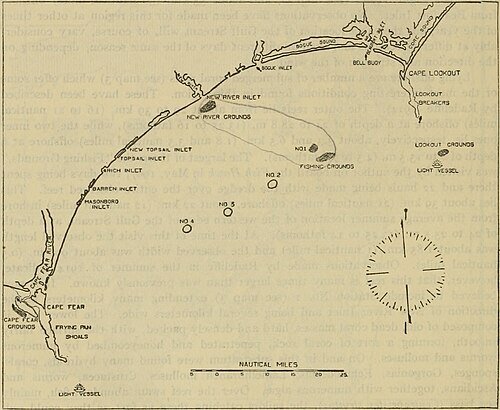
m (GR) File renamed: File:FMIB 47831 Location of known 'fishing grounds,' mostly submerged coral reefs, offshore from the region of Beaufort, NC (From Radcliffe.jpeg → File:Map of Onslow Bay North Carolina.jpg Criterion 2 (meaningless or ambiguous name) · Nom trop long confondu avec la description du lieu |
||
| (One intermediate revision by one other user not shown) | |||
| Line 1: | Line 1: | ||
[[File: |
[[File:Map of Onslow Bay North Carolina.jpg|thumb|right|500px|Map of Onslow Bay.]] |
||
'''Onslow Bay''' is an indentation of the [[North Carolina]] coast, between [[Cape Fear (headland)|Cape Fear]] in the south and [[Cape Lookout (North Carolina)|Cape Lookout]] in the north. Thirteen [[barrier island]]s form the shore of the bay. It is part of the open [[Atlantic Ocean]] and affords no protection from oceanic swells. |
'''Onslow Bay''' is an indentation of the [[North Carolina]] coast, between [[Cape Fear (headland)|Cape Fear]] in the south and [[Cape Lookout (North Carolina)|Cape Lookout]] in the north. Thirteen [[barrier island]]s form the shore of the bay. It is part of the open [[Atlantic Ocean]] and affords no protection from oceanic swells. |
||
| Line 6: | Line 6: | ||
{{Outer Banks}} |
{{Outer Banks}} |
||
{{Authority control}} |
|||
{{Coord|34.5984286|-77.2002745|scale:1000000|display=title}} |
{{Coord|34.5984286|-77.2002745|scale:1000000|display=title}} |
||
Latest revision as of 23:14, 30 November 2021

Onslow Bay is an indentation of the North Carolina coast, between Cape Fear in the south and Cape Lookout in the north. Thirteen barrier islands form the shore of the bay. It is part of the open Atlantic Ocean and affords no protection from oceanic swells.
External links
[edit]34°35′54″N 77°12′01″W / 34.5984286°N 77.2002745°W
