Kolomak Raion: Difference between revisions
Appearance
Content deleted Content added
Yulia Romero (talk | contribs) Typo Tags: Mobile edit Mobile web edit |
wl |
||
| (23 intermediate revisions by 6 users not shown) | |||
| Line 1: | Line 1: | ||
{{Short description|Former subdivision of Kharkiv Oblast, Ukraine}} |
|||
{{Infobox settlement |
{{Infobox settlement |
||
|name = |
|name =Kolomak Raion |
||
|other_name = |
|other_name = |
||
|native_name = Коломацький район |
|native_name = Коломацький район |
||
| Line 14: | Line 15: | ||
|pushpin_label_position =right |
|pushpin_label_position =right |
||
|pushpin_map_caption = |
|pushpin_map_caption = |
||
| ⚫ | |||
|coordinates_display = inline,title |
|||
|coordinates_region = |
|||
|subdivision_type = [[List of sovereign states|Country]] |
|subdivision_type = [[List of sovereign states|Country]] |
||
|subdivision_name ={{flag|Ukraine}} |
|subdivision_name ={{flag|Ukraine}} |
||
| Line 24: | Line 24: | ||
|leader_title = |
|leader_title = |
||
|leader_name = |
|leader_name = |
||
| |
| established_title1 = Established |
||
| |
| established_date1 = |
||
| established_title2 = Disestablished |
|||
| established_date2 = 18 July 2020 |
|||
|area_total_km2 = 330 |
|area_total_km2 = 330 |
||
|population_as_of = |
|population_as_of = 2020 |
||
|population_footnotes = |
|population_footnotes = |
||
|population_total = |
|population_total = 6677 |
||
|population_density_km2 = |
|population_density_km2 = auto |
||
|timezone = EET |
|timezone = EET |
||
|utc_offset = +2 |
|utc_offset = +2 |
||
|timezone_DST = EEST |
|timezone_DST = EEST |
||
|utc_offset_DST = +3 |
|utc_offset_DST = +3 |
||
|latd=|latm=|lats=|latNS=N |
|||
|longd=|longm=|longs=|longEW=E |
|||
|elevation_footnotes = |
|elevation_footnotes = |
||
| ⚫ | |||
|elevation_m = |
|elevation_m = |
||
|elevation_ft = |
|elevation_ft = |
||
| Line 44: | Line 44: | ||
|footnotes = |
|footnotes = |
||
}} |
}} |
||
''' |
'''Kolomak Raion''' ({{Lang-uk|Коломацький район}}) was a [[raion]] ([[district]]) in [[Kharkiv Oblast]] of [[Ukraine]]. Its [[administrative center]] was the [[urban-type settlement]] of [[Kolomak]]. The raion was abolished on 18 July 2020 as part of the administrative reform of Ukraine, which reduced the number of raions of Kharkiv Oblast to seven. The area of Kolomak Raion was merged into [[Bohodukhiv Raion]].<ref>{{Cite news|title=Про утворення та ліквідацію районів. Постанова Верховної Ради України № 807-ІХ.|url=http://www.golos.com.ua/article/333466|access-date=2020-10-03|date=2020-07-18|website=Голос України|language=uk}}</ref><ref>{{cite web |title=Нові райони: карти + склад |url=https://www.minregion.gov.ua/press/news/novi-rajony-karty-sklad/ |publisher=Міністерство розвитку громад та територій України |language=Ukrainian}}</ref> The last estimate of the raion population was {{Ua-pop-est2020|6,677}} |
||
At the time of disestablishment, the raion consisted of one [[hromada]],<ref>{{cite web |title=Коломацька районна рада (состав до 2020 г.) |url=https://gromada.info/ru/region/Харьковская-область/Коломакский-район/ |publisher=Портал об'єднаних громад України |language=Russian}}</ref> [[Kolomak settlement hromada]] with the administration in Kolomak. |
|||
| ⚫ | |||
| ⚫ | |||
In Kolomak [[Ivan Mazepa]] was elected the [[Cossack Hetmanate|Hetman]] of [[Left-bank Ukraine]] in 1687.<ref>{{cite book|author1=[[Ivan Katchanovski]] |author2=Zenon E. Kohut |author3=Bohdan Y. Nebesio |author4=Myroslav Yurkevich |title="Ivan Mazepa" entry in Historical Dictionary of Ukraine|date=2013|publisher=Scarecrow Press|isbn=9780810878471|page=362|url=https://books.google.com/books?id=-h6r57lDC4QC&dq=kolomak+Mazepa&pg=PA362}}</ref> A monument of him was unveiled in July 2017 in Kolomak.<ref>{{in lang|ru}} [http://www.sq.com.ua/rus/news/novosti/22.07.2017/v_harkovskoy_oblasti_otkryli_pamyatnik_ivanu_mazepe_foto/ A monument to Ivan Mazepa was opened in the Kharkiv region (photo)], SQ (23 July 2017)</ref> |
|||
[[Category:Raions of Kharkiv Oblast]] |
|||
| ⚫ | |||
| ⚫ | |||
[[Category:Former raions of Kharkiv Oblast]] |
|||
[[Category:1923 establishments in Ukraine]] |
|||
[[Category:Ukrainian raions abolished during the 2020 administrative reform]] |
|||
{{Authority control}} |
|||
{{Kharkiv-geo-stub}} |
|||
Latest revision as of 13:31, 21 June 2022
Kolomak Raion
Коломацький район | |
|---|---|
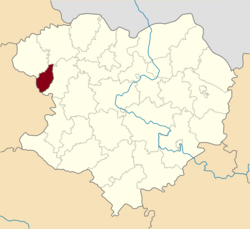
 Raion location in Kharkiv Oblast | |
| Coordinates: 49°50′13.1778″N 35°17′55.3416″E / 49.836993833°N 35.298706000°E | |
| Land | |
| Oblast | Kharkiv Oblast |
| Disestablished | 18 July 2020 |
| Admin. center | Kolomak |
| Area | |
| • Total | 330 km2 (130 sq mi) |
| Population (2020) | |
| • Total | 6,677 |
| • Density | 20/km2 (52/sq mi) |
| Time zone | UTC+2 (EET) |
| • Summer (DST) | UTC+3 (EEST) |
| Website | http://kolomakrda.gov.ua |
Kolomak Raion (Ukrainian: Коломацький район) was a raion (district) in Kharkiv Oblast of Ukraine. Its administrative center was the urban-type settlement of Kolomak. The raion was abolished on 18 July 2020 as part of the administrative reform of Ukraine, which reduced the number of raions of Kharkiv Oblast to seven. The area of Kolomak Raion was merged into Bohodukhiv Raion.[1][2] The last estimate of the raion population was 6,677 (2020 est.)[3]
At the time of disestablishment, the raion consisted of one hromada,[4] Kolomak settlement hromada with the administration in Kolomak.
In Kolomak Ivan Mazepa was elected the Hetman of Left-bank Ukraine in 1687.[5] A monument of him was unveiled in July 2017 in Kolomak.[6]
References
[edit]- ^ "Про утворення та ліквідацію районів. Постанова Верховної Ради України № 807-ІХ". Голос України (in Ukrainian). 2020-07-18. Retrieved 2020-10-03.
- ^ "Нові райони: карти + склад" (in Ukrainian). Міністерство розвитку громад та територій України.
- ^ Чисельність наявного населення України на 1 січня 2020 року / Population of Ukraine Number of Existing as of January 1, 2020 (PDF) (in Ukrainian and English). Kyiv: State Statistics Service of Ukraine. Archived (PDF) from the original on 28 September 2023.
- ^ "Коломацька районна рада (состав до 2020 г.)" (in Russian). Портал об'єднаних громад України.
- ^ Ivan Katchanovski; Zenon E. Kohut; Bohdan Y. Nebesio; Myroslav Yurkevich (2013). "Ivan Mazepa" entry in Historical Dictionary of Ukraine. Scarecrow Press. p. 362. ISBN 9780810878471.
- ^ (in Russian) A monument to Ivan Mazepa was opened in the Kharkiv region (photo), SQ (23 July 2017)


