
Buitenpost: Difference between revisions
No edit summary |
→top: added a dialing code Tags: Mobile edit Mobile app edit Android app edit |
||
| (15 intermediate revisions by 13 users not shown) | |||
| Line 1: | Line 1: | ||
{{Infobox |
{{Infobox settlement |
||
| |
| name = Buitenpost |
||
| |
| native_name = Bûtenpost |
||
| native_name_lang = <!-- ISO 639-2 code e.g. "fr" for French. If more than one, use {{lang}} instead --> |
|||
|mapsize = 280px |
|||
| settlement_type = Village |
|||
|image_flag = Buitenpost vlag.svg |
|||
| image_skyline = Buitenpost, de Mariakerk RM7036 foto4 2013-08-25 14.30.JPG |
|||
|flag_size = 120x100px |
|||
| image_alt = |
|||
|image_shield = Buitenpost wapen.svg |
|||
| image_caption = Maria Church |
|||
|shield_size = 120x100px |
|||
| image_flag = Buitenpost vlag.svg |
|||
|subdivision_type = Country |
|||
| flag_alt = |
|||
|subdivision_name = {{flagicon|Netherlands}} [[Netherlands]] |
|||
| image_seal = |
|||
|subdivision_type1 = Province |
|||
| seal_alt = |
|||
|subdivision_name1 = {{flagicon|Friesland}} [[Friesland]] |
|||
| image_shield = Buitenpost wapen.svg |
|||
|settlement_type = Village |
|||
| shield_alt = |
|||
|population_total = 5834 (1 january 2012) |
|||
| etymology = |
|||
| motto = |
|||
| image_map = Map NL Achtkarspelen Bûtenpost.png |
|||
| map_alt = |
|||
| map_caption = Location in Achtkarspelen municipality |
|||
| pushpin_map = Netherlands<!-- the name of a location map as per http://en.wikipedia.org/wiki/Template:Location_map --> |
|||
| pushpin_label_position = left |
|||
| pushpin_mapsize = 250 |
|||
| pushpin_map_caption = Location in the Netherlands |
|||
| coordinates = {{coord|53|15|N|6|09|E|region:NL_type:city|display=title}} |
|||
| coor_pinpoint = |
|||
| coordinates_footnotes = |
|||
| subdivision_type = Country |
|||
| subdivision_name = {{flagicon|Netherlands}} [[Netherlands]] |
|||
| subdivision_type1 = [[Provinces of the Netherlands|Province]] |
|||
| subdivision_name1 = {{flagicon|Friesland}} [[Friesland]] |
|||
| subdivision_type2 = [[List of municipalities of the Netherlands|Municipality]] |
|||
| subdivision_name2 = {{flagicon|Achtkarspelen}} [[Achtkarspelen]] |
|||
| subdivision_type3 = |
|||
| subdivision_name3 = |
|||
| established_title = |
|||
| established_date = |
|||
| founder = |
|||
| seat_type = |
|||
| seat = |
|||
| government_footnotes = |
|||
| leader_party = |
|||
| leader_title = |
|||
| leader_name = |
|||
| unit_pref = Metric |
|||
<!-- ALL fields with measurements have automatic unit conversion --> |
|||
<!-- for references: use <ref> tags --> |
|||
| area_footnotes = <ref name="stat"/> |
|||
| area_total_km2 = 18.55 |
|||
| elevation_footnotes = <ref name="AHN">{{cite web |url = http://www.ahn.nl/postcodetool |title = Postcodetool for 9285JA |language = nl |work = Actueel Hoogtebestand Nederland |publisher = Het Waterschapshuis |access-date = 29 March 2022 }}</ref> |
|||
| elevation_m = 0.1 |
|||
| population_as_of = 2021 |
|||
| population_footnotes = <ref name="stat">{{cite web |url=https://www.cbs.nl/-/media/_excel/2021/48/kwb-2021.xls |title=Kerncijfers wijken en buurten 2021 |website=Central Bureau of Statistics |access-date=29 March 2022 |quote=two entries}}</ref> |
|||
| population_total = 5,770 |
|||
| population_density_km2 = auto |
|||
| population_note = |
|||
| population_demonym = |
|||
| timezone1 = |
|||
| utc_offset1 = |
|||
| timezone1_DST = |
|||
| utc_offset1_DST = |
|||
| timezone = [[Central European Time|CET]] |
|||
| utc_offset = +1 |
|||
| timezone_DST = [[Central European Summer Time|CEST]] |
|||
| utc_offset_DST = +2 |
|||
| postal_code_type = [[List of postal codes in the Netherlands|Postal code]] |
|||
| postal_code = 9285<ref name="stat"/> |
|||
| area_code_type = [[Telephone numbers in the Netherlands|Dialing code]] |
|||
| area_code = 0511-0512 |
|||
| iso_code = |
|||
| footnotes = |
|||
| website = [http://www.binnenbuitenpost.nl/ Official] |
|||
}} |
}} |
||
'''Buitenpost''' (''Bûtenpost'' in [[West Frisian language|West Frisian]]) is a town in north-east [[Friesland]] in the [[Netherlands]]. |
|||
'''Buitenpost''' (''Bûtenpost'' in [[West Frisian language|West Frisian]]) is a village in north-east [[Friesland]] in the [[Netherlands]]. |
|||
It lies approximately halfway between the cities of [[Leeuwarden]] (the capital of Friesland) and [[Groningen (city)|Groningen]], in the northern part of the [[Municipalities of the Netherlands|municipality]] of [[Achtkarspelen]]. With 5,765 inhabitants, Buitenpost is the second largest settlement in the [[municipality]]. |
|||
It lies approximately halfway between the cities of [[Leeuwarden]] (the capital of Friesland) and [[Groningen (city)|Groningen]], in the northern part of the [[Municipalities of the Netherlands|municipality]] of [[Achtkarspelen]]. With 5,762 inhabitants,<ref>[https://www.achtkarspelen.nl/inwoners-achtkarspelen/dorpen-in-achtkarspelen_44681/ Villages] {{Webarchive|url=https://web.archive.org/web/20170422033234/https://www.achtkarspelen.nl/inwoners-achtkarspelen/dorpen-in-achtkarspelen_44681/ |date=2017-04-22 }} - Achtkarspelen {{in lang|nl}}</ref> Buitenpost is the second largest settlement in the [[Municipalities of the Netherlands|municipality]].<ref name="stat"/> |
|||
Buitenpost is home to the Netherlands' largest [[botanical garden|botanical herbal garden]] |
|||
Buitenpost is home to the Netherlands' largest [[botanical garden|botanical herbal garden]].<ref>{{cite web|url=https://www.museum.nl/nl/botanische-tuin-de-kruidhof |title=Botanische Tuin De Kruidhof |website=Museum.nl |access-date=29 March 2022 |language=nl}}</ref><ref name="plaats"/> |
|||
More information on Buitenpost and its inhabitants can be found on the site of the local community-organization www.binnenbuitenpost.nl |
|||
== History == |
|||
The village was first mentioned in 1388 as Post, and means outside bridge. Buiten (outside) was added to distinguish from the hamlet of {{ill|Lutkepost|nl}}.<ref>{{cite web|url=https://etymologiebank.nl/trefwoord/buitenpost |title=Buitenpost - (geografische naam) |website=Etymologiebank |access-date=29 March 2022 |language=nl}}</ref> Buitenpost is a road village which developed along the main road from [[Leeuwarden]] to [[Groningen]], and became the capital of the ''grietenij'' (predecessor of a municipality) Achtkarspelen.<ref name="monument"/> |
|||
The tower of the [[Protestant church of Buitenpost|Protestant church]] was constructed around 1200 and enlarged in the 16th century. The church dates from the 15th century, but was damaged in a fire in 1594, and restored between 1611 and 1613. There were two ''[[stins]]es'' (villas) near Buitenpost: Herbrandastate which was demolished in 1780 and Haersmastate which was demolished around 1910.<ref name="monument">{{cite web|url=https://www.dbnl.org/tekst/sten009monu06_01/sten009monu06_01_0171.php |title=Surhuisterveen |author=Ronald Stenvert & Sabine Broekhoven |year=2000 |publisher=Waanders |location=Zwolle |isbn=90 400 9476 4 |language=nl |access-date=29 March 2022}}</ref> In 1840, it was home to 882 people.<ref name="plaats">{{cite web|url=https://www.plaatsengids.nl/buitenpost |title=Buitenpost |website=Plaatsengids |access-date=29 March 2022 |language=nl}}</ref> |
|||
In 1866, [[Buitenpost railway station]] was opened in the village.<ref>{{cite web|url=http://stationsweb.nl/station.asp?station=buitenpost&vraag=buitenpost |title=station Buitenpost |website=Stationsweb |access-date=29 March 2022 |language=nl}}</ref> Wind mill [[De Mûnts, Buitenpost|De Mûnts]] is a polder mill constructed in 1871. Its purpose was to remove the excess water from the low-lying ''[[polder]]''. The mill was located in {{ill|Oosterhoogebrug|nl}}, Groningen, and was needed for the construction of the {{ill|Eemskanaal|nl}}. On 7 July 1952, it was scheduled for demolition, but was bought by Wolter Bakker and moved to Buitenpost to replace an engine powered pumping station.<ref>{{cite web|url=https://molendatabase.nl/nederland/molen.php?nummer=50 |title=De Mûnts |website=Molen database |access-date=29 March 2022 |language=nl}}</ref> |
|||
==Notable buildings== |
==Notable buildings== |
||
| Line 28: | Line 90: | ||
== Gallery == |
== Gallery == |
||
<gallery> |
<gallery> |
||
File:De Kruidhof Buitenpost rosarium.jpg|[[Rosarium]] in the {{Interlanguage link multi|Botanische Tuin De Kruidhof|nl}} |
|||
File:Buitenpost, de Mariakerk RM7036 foto4 2013-08-25 14.30.JPG|Buitenpost, church: de Mariakerk |
|||
File:De Mûnts poldermolen.JPG|[[De Mûnts, Buitenpost]] |
|||
File:Buitenpost, standbeeld en pizzeria foto2 2013-08-25 14.24.JPG|Buitenpost, statue and pizzeria |
|||
File:Buitenpost, uitzendbureau in monumentaal pand foto5 2013-08-25 14.20.JPG| |
File:Buitenpost, uitzendbureau in monumentaal pand foto5 2013-08-25 14.20.JPG|[[Employment agency]] in monumental building |
||
File:Kerk Buitenpost interieur.jpg|Church interior (Buitenpost) |
|||
File:Buitenpost windmill.JPG|Windmill (Buitenpost) |
|||
</gallery> |
</gallery> |
||
==Transportation== |
==Transportation== |
||
*[[Buitenpost railway station]] |
*[[Buitenpost railway station]] |
||
==References== |
|||
{{coord|53|15|N|6|09|E|region:NL_type:city|display=title}} |
|||
{{Reflist}} |
|||
==External links== |
|||
* {{official|http://www.binnenbuitenpost.nl/ }} |
|||
{{commons category-inline}} |
|||
{{Achtkarspelen}} |
|||
[[Category:Achtkarspelen]] |
[[Category:Achtkarspelen]] |
||
[[Category:Populated places in Friesland]] |
[[Category:Populated places in Friesland]] |
||
{{Achtkarspelen}} |
|||
Latest revision as of 22:43, 22 July 2022
Buitenpost
Bûtenpost | |
|---|---|
Village | |
 Maria Church | |
 Flag  Coat of arms | |
 Location in Achtkarspelen municipality | |
 Buitenpost Location in the Netherlands | |
| Coordinates: 53°15′N 6°09′E / 53.250°N 6.150°E | |
| Land | |
| Province | |
| Municipality | |
| Area | |
| • Total | 18.55 km2 (7.16 sq mi) |
| Elevation | 0.1 m (0.3 ft) |
| Population (2021)[1] | |
| • Total | 5,770 |
| • Density | 310/km2 (810/sq mi) |
| Postal code | 9285[1] |
| Dialing code | 0511-0512 |
| Website | Official |
Buitenpost (Bûtenpost in West Frisian) is a village in north-east Friesland in the Netherlands.
It lies approximately halfway between the cities of Leeuwarden (the capital of Friesland) and Groningen, in the northern part of the municipality of Achtkarspelen. With 5,762 inhabitants,[3] Buitenpost is the second largest settlement in the municipality.[1]
Buitenpost is home to the Netherlands' largest botanical herbal garden.[4][5]
History
[edit]The village was first mentioned in 1388 as Post, and means outside bridge. Buiten (outside) was added to distinguish from the hamlet of Lutkepost.[6] Buitenpost is a road village which developed along the main road from Leeuwarden to Groningen, and became the capital of the grietenij (predecessor of a municipality) Achtkarspelen.[7]
The tower of the Protestant church was constructed around 1200 and enlarged in the 16th century. The church dates from the 15th century, but was damaged in a fire in 1594, and restored between 1611 and 1613. There were two stinses (villas) near Buitenpost: Herbrandastate which was demolished in 1780 and Haersmastate which was demolished around 1910.[7] In 1840, it was home to 882 people.[5]
In 1866, Buitenpost railway station was opened in the village.[8] Wind mill De Mûnts is a polder mill constructed in 1871. Its purpose was to remove the excess water from the low-lying polder. The mill was located in Oosterhoogebrug, Groningen, and was needed for the construction of the Eemskanaal. On 7 July 1952, it was scheduled for demolition, but was bought by Wolter Bakker and moved to Buitenpost to replace an engine powered pumping station.[9]
Notable buildings
[edit]Gallery
[edit]-
![Rosarium in the Botanische Tuin De Kruidhof [nl]](//upload.wikimedia.org/wikipedia/commons/thumb/5/56/De_Kruidhof_Buitenpost_rosarium.jpg/120px-De_Kruidhof_Buitenpost_rosarium.jpg)
-

-
 Employment agency in monumental building
 -
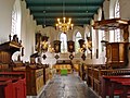 Church interior (Buitenpost)
 -
 Windmill (Buitenpost)
![Rosarium in the Botanische Tuin De Kruidhof [nl]](/wiki/File:De_Kruidhof_Buitenpost_rosarium.jpg)


Transport
[edit]References
[edit]- ^ a b c d "Kerncijfers wijken en buurten 2021". Central Bureau of Statistics. Retrieved 29 March 2022.
two entries
- ^ "Postcodetool for 9285JA". Actueel Hoogtebestand Nederland (in Dutch). Het Waterschapshuis. Retrieved 29 March 2022.
- ^ Villages Archived 2017-04-22 at the Wayback Machine - Achtkarspelen (in Dutch)
- ^ "Botanische Tuin De Kruidhof". Museum.nl (in Dutch). Retrieved 29 March 2022.
- ^ a b "Buitenpost". Plaatsengids (in Dutch). Retrieved 29 March 2022.
- ^ "Buitenpost - (geografische naam)". Etymologiebank (in Dutch). Retrieved 29 March 2022.
- ^ a b Ronald Stenvert & Sabine Broekhoven (2000). "Surhuisterveen" (in Dutch). Zwolle: Waanders. ISBN 90 400 9476 4. Retrieved 29 March 2022.
- ^ "station Buitenpost". Stationsweb (in Dutch). Retrieved 29 March 2022.
- ^ "De Mûnts". Molen database (in Dutch). Retrieved 29 March 2022.
External links
[edit]![]() Media related to Buitenpost at Wikimedia Commons
Media related to Buitenpost at Wikimedia Commons
