Banda Sea Plate: Difference between revisions
Citation bot (talk | contribs) Add: bibcode. | Use this bot. Report bugs. | Suggested by Whoop whoop pull up | Category:Tectonic plates | #UCB_Category 3/88 |
|||
| (21 intermediate revisions by 16 users not shown) | |||
| Line 1: | Line 1: | ||
{{short description|Minor tectonic plate underlying the Banda Sea in southeast Asia}} |
|||
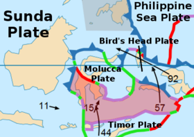
[[Image:Sunda Plate map-fr.png|thumb|right|375x375px|Map of the Banda Sea Plate (as "Mer de Banda") and its neighbouring plates (in [[French language|French]])]] |
|||
{{Infobox tectonic plate |
|||
| image = File:BandaSeaPlate.png |
|||
| alt = The Banda Sea Plate |
|||
| type = [[List of tectonic plates#Minor plates|Minor]] |
|||
| move_direction = north |
|||
| move_speed = 15-57 mm/year |
|||
| geo_features = [[Sulawesi Island]], [[Banda Sea]] |
|||
}} |
|||
| ⚫ | The '''Banda Sea Plate''' is a minor [[tectonic plate]] underlying the [[Banda Sea]] in southeast [[Asia]]. This plate also carries a portion of [[Sulawesi Island]], the entire [[Seram Island]], and the [[Banda Islands]]. Clockwise from the east it is bounded by the [[Bird's Head Plate]] of western [[New Guinea]], [[Australian Plate]], [[Timor Plate]], [[Sunda Plate]], and the [[Molucca Sea Collision Zone]]. The western border is a [[convergent boundary]] largely responsible for the mountains in western Sulawesi, [[subduction zones]] also exist on the eastern border near Seram and the southern border with the [[Timor Plate]]. A small [[Rift (geology)|rift]] is located in the middle of Sulawesi. It is a very [[seismically active]] area home to many [[volcano]]es and the site of many large earthquakes, the largest of which was the [[1938 Banda Sea earthquake]] which measured around 8.4 on the [[moment magnitude scale]]. |
||
==See also== |
|||
| ⚫ | The '''Banda Sea Plate''' is a |
||
*{{annotated link|Banda Arc}} |
|||
*{{annotated link|List of earthquakes in Indonesia}} |
|||
==References== |
==References== |
||
*{{cite journal|last=Bird|first=P.| |
*{{cite journal|last=Bird|first=P.|year=2003|title=An updated digital model of plate boundaries|journal=Geochemistry, Geophysics, Geosystems|volume=4|issue=3|pages=1027|url=http://peterbird.name/publications/2003_PB2002/2003_PB2002.htm|doi=10.1029/2001GC000252|bibcode=2003GGG.....4.1027B |doi-access=free}} |
||
{{Tectonic plates}} |
|||
{{SE Asia plates}} |
{{SE Asia plates}} |
||
{{DEFAULTSORT:Banda Sea Plates}} |
|||
[[Category:Tectonic plates]] |
[[Category:Tectonic plates]] |
||
[[Category:Geology of Indonesia]] |
[[Category:Geology of Indonesia]] |
||
[[Category:Geology of the Pacific Ocean]] |
[[Category:Geology of the Pacific Ocean]] |
||
[[Category:Banda Sea]] |
[[Category:Banda Sea]] |
||
{{tectonics-stub}} |
{{tectonics-stub}} |
||
[[ca:Placa de la mar de Banda]] |
|||
[[eu:Banda itsasoko plaka]] |
|||
[[fr:Plaque de la mer de Banda]] |
|||
[[ja:バンダ海プレート]] |
|||
[[uk:Плита моря Банда]] |
|||
[[zh:班達海板塊]] |
|||
Latest revision as of 21:46, 30 August 2022
| Banda Sea Plate | |
|---|---|
 | |
| Typ | Minor |
| Movement1 | north |
| Speed1 | 15-57 mm/year |
| Eigenschaften | Sulawesi Island, Banda Sea |
| 1Relative to the African Plate | |
The Banda Sea Plate is a minor tectonic plate underlying the Banda Sea in southeast Asia. This plate also carries a portion of Sulawesi Island, the entire Seram Island, and the Banda Islands. Clockwise from the east it is bounded by the Bird's Head Plate of western New Guinea, Australian Plate, Timor Plate, Sunda Plate, and the Molucca Sea Collision Zone. The western border is a convergent boundary largely responsible for the mountains in western Sulawesi, subduction zones also exist on the eastern border near Seram and the southern border with the Timor Plate. A small rift is located in the middle of Sulawesi. It is a very seismically active area home to many volcanoes and the site of many large earthquakes, the largest of which was the 1938 Banda Sea earthquake which measured around 8.4 on the moment magnitude scale.
See also
[edit]- Banda Arc – Set of island arcs in eastern Indonesia
- List of earthquakes in Indonesia
References
[edit]- Bird, P. (2003). "An updated digital model of plate boundaries". Geochemistry, Geophysics, Geosystems. 4 (3): 1027. Bibcode:2003GGG.....4.1027B. doi:10.1029/2001GC000252.

