
Salt Creek Recreation Area: Difference between revisions
added info from FortWiki.com |
other names and namesake info |
||
| (13 intermediate revisions by 11 users not shown) | |||
| Line 1: | Line 1: | ||
[[File:SALTCREEKSEASTACK1.JPG|thumb|350px|right |
[[File:SALTCREEKSEASTACK1.JPG|thumb|350px|right]] |
||
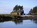
'''Salt Creek Recreation Area''' is a 196 |
'''Salt Creek Recreation Area''' is a 196-acre park located about 15 miles west of [[Port Angeles, Washington]] on [[U.S. Route 101 in Washington|U.S. Route 101]] near the city of Joyce, Washington. The park was previously '''Camp Hayden''', a World War II military camp built 1942–1945. The site was established as the '''Striped Peak Military Reservation''' in 1941, renamed as Camp Hayden on 22 October 1942, and renamed again as '''Fort Hayden''' on 17 April 1944. It was named for Brigadier General [[John Louis Hayden]], a former commander of the [[Harbor Defenses of Puget Sound]]. It was purchased by the Federal General Services Administration after the war. There are still several structures left from the fort, including two large [[casemates]] which sheltered 16" guns and several other structures. The 16-inch battery was Battery 131, with two ex-Navy [[16"/50 caliber Mark 2 gun|16-inch Mark 2 guns]] capable of firing a one-ton projectile around 28 miles connected by a large [[magazine (artillery)|magazine]] bunker. The camp also had Battery 249, which had two [[6-inch gun M1|6-inch guns]] with a bunker housing magazines and [[fire-control system|fire control]] equipment.<ref>[http://www.fortwiki.com/Camp_Hayden Camp Hayden at FortWiki.com]</ref> |
||
The park now has a number of camping spots, most overlooking the [[Strait of Juan de Fuca]] and |
The park now has a number of camping spots, most overlooking the [[Strait of Juan de Fuca]] and mountains all year long. The park provides access to [[Tongue Point]] and [[Striped Peak]] along with sandy beaches, upland forests, rocky bluffs, and several trails. The recreation area complete with a baseball field, basketball court, picnic shelter, playground, and horseshoe pits is also available for use. The park hosts the Salt Creek Invitational cross country meet in mid-September every year, featuring high school teams from around western Washington. Beautiful views are also a big part of Salt Creek such as those from the top of Striped Peak, of Crescent Bay, of the Strait, and of Vancouver Island, British Columbia. |
||
==Gallery== |
==Gallery== |
||
<gallery perrow=4 |
<gallery perrow=4> |
||
File:salt creek park.jpg|View of Beach Area. |
File:salt creek park.jpg|View of Beach Area. |
||
File:Camphaydenbigbunker.JPG|16 inch gun casemate, front view, where the gun was mounted. Note the red-colored projectiles. |
File:Camphaydenbigbunker.JPG|16 inch gun casemate, front view, where the gun was mounted. Note the red-colored projectiles. |
||
File:Saltcreekbunker.JPG|Back view of a casemate. |
File:Saltcreekbunker.JPG|Back view of a casemate. |
||
File:SALTCREEKUPLAND.jpg|View of ocean from near campground. |
File:SALTCREEKUPLAND.jpg|View of ocean from near campground. |
||
</gallery |
</gallery> |
||
==References== |
|||
<references /> |
|||
==External links== |
==External links== |
||
Latest revision as of 17:27, 26 December 2022

Salt Creek Recreation Area is a 196-acre park located about 15 miles west of Port Angeles, Washington on U.S. Route 101 near the city of Joyce, Washington. The park was previously Camp Hayden, a World War II military camp built 1942–1945. The site was established as the Striped Peak Military Reservation in 1941, renamed as Camp Hayden on 22 October 1942, and renamed again as Fort Hayden on 17 April 1944. It was named for Brigadier General John Louis Hayden, a former commander of the Harbor Defenses of Puget Sound. It was purchased by the Federal General Services Administration after the war. There are still several structures left from the fort, including two large casemates which sheltered 16" guns and several other structures. The 16-inch battery was Battery 131, with two ex-Navy 16-inch Mark 2 guns capable of firing a one-ton projectile around 28 miles connected by a large magazine bunker. The camp also had Battery 249, which had two 6-inch guns with a bunker housing magazines and fire control equipment.[1]
The park now has a number of camping spots, most overlooking the Strait of Juan de Fuca and mountains all year long. The park provides access to Tongue Point and Striped Peak along with sandy beaches, upland forests, rocky bluffs, and several trails. The recreation area complete with a baseball field, basketball court, picnic shelter, playground, and horseshoe pits is also available for use. The park hosts the Salt Creek Invitational cross country meet in mid-September every year, featuring high school teams from around western Washington. Beautiful views are also a big part of Salt Creek such as those from the top of Striped Peak, of Crescent Bay, of the Strait, and of Vancouver Island, British Columbia.
Gallery
[edit]-
 View of Beach Area.
 -
 16 inch gun casemate, front view, where the gun was mounted. Note the red-colored projectiles.
 -
 Back view of a casemate.
 -
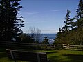 View of ocean from near campground.


