Koch Island: Difference between revisions
Appearance
Content deleted Content added
clean up using AWB |
mNo edit summary Tags: Mobile edit Mobile app edit iOS app edit |
||
| (42 intermediate revisions by 30 users not shown) | |||
| Line 1: | Line 1: | ||
{{Short description|Uninhabited island off Baffin Island in northern Canada}} |
|||
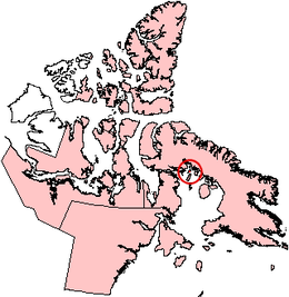
[[Image:Kochisland.png|thumb|right|Koch Island, Nunavut.]] |
|||
{{For|the mathematical curve|Koch snowflake}} |
|||
'''Koch Island''' is one of the [[Canadian arctic islands]] in [[Nunavut]], [[Canada]], located on the southern coast of [[Baffin Island]]. Its position is 69°38'N 78°20'W and it has an area of 458 square kilometers. |
|||
{{Use dmy dates|date=April 2021}} |
|||
{{Infobox islands |
|||
| name = Koch Island |
|||
| image_name = Kochisland.png |
|||
| image_caption = Koch Island, Nunavut. |
|||
| image_size = |
|||
| pushpin_map = Canada Nunavut#Canada |
|||
| native_name = |
|||
| native_name_link = Inuktitut |
|||
| nickname = |
|||
| location = [[Foxe Basin]] |
|||
| coordinates = {{Coord|69|38|N|78|20|W|region:CA-NU_type:isle|display=inline,title|name=Koch Island}} |
|||
| archipelago = [[Arctic Archipelago]] |
|||
| total_islands = |
|||
| major_islands = |
|||
| area_km2 = 458 |
|||
| highest_mount = |
|||
| elevation_m = |
|||
| country = Canada |
|||
| country_admin_divisions_title = [[Provinces and territories of Canada|Nunavut]] |
|||
| country_admin_divisions = [[Nunavut]] |
|||
| country_admin_divisions_title_1 = [[Regions of Nunavut|Region]] |
|||
| country_admin_divisions_1 = [[Qikiqtaaluk Region|Qikiqtaaluk]] |
|||
| country_admin_divisions_title_2 = |
|||
| country_admin_divisions_2 = |
|||
| country_largest_city = |
|||
| country_largest_city_population = |
|||
| country_leader_title = |
|||
| country_leader_name = |
|||
| population = Uninhabited |
|||
| population_as_of = |
|||
| density_km2 = |
|||
| ethnic_groups = |
|||
| additional_info = |
|||
}} |
|||
'''Koch Island''' is one of the [[Arctic Archipelago|Canadian Arctic islands]] in [[Qikiqtaaluk Region]], [[Nunavut]], Canada. Located in [[Foxe Basin]], it is an uninhabited [[Baffin Island]] offshore island. Located at 69°38'N 78°20'W, it has an area of {{Convert|458|km2|abbr=on}}.<ref>{{Cite web|title=The Atlas of Canada – Sea Islands |url=http://atlas.nrcan.gc.ca/auth/english/learningresources/facts/islands.html |publisher=Natural Resources Canada |access-date=5 May 2011 |url-status=dead |archive-url=https://web.archive.org/web/20100702145716/http://atlas.nrcan.gc.ca/auth/english/learningresources/facts/islands.html |archive-date=2 July 2010 }} |
|||
| ⚫ | |||
</ref> |
|||
==References== |
|||
{{Reflist}} |
|||
{{Islands of the Qikiqtaaluk Region}} |
|||
| ⚫ | |||
{{Authority control}} |
|||
| ⚫ | |||
[[Category:Uninhabited islands of Qikiqtaaluk Region]] |
|||
| ⚫ | |||
Latest revision as of 14:14, 11 January 2023
 Koch Island, Nunavut. | |
| Geography | |
|---|---|
| Location | Foxe Basin |
| Coordinates | 69°38′N 78°20′W / 69.633°N 78.333°W |
| Archipelago | Arctic Archipelago |
| Area | 458 km2 (177 sq mi) |
| Administration | |
Canada | |
| Nunavut | Nunavut |
| Region | Qikiqtaaluk |
| Demographics | |
| Population | Uninhabited |
Koch Island is one of the Canadian Arctic islands in Qikiqtaaluk Region, Nunavut, Canada. Located in Foxe Basin, it is an uninhabited Baffin Island offshore island. Located at 69°38'N 78°20'W, it has an area of 458 km2 (177 sq mi).[1]
References
[edit]- ^ "The Atlas of Canada – Sea Islands". Natural Resources Canada. Archived from the original on 2 July 2010. Retrieved 5 May 2011.


