Swinomish Channel: Difference between revisions
==References== <references/> |
m →top: excess comma |
||
| (17 intermediate revisions by 15 users not shown) | |||
| Line 1: | Line 1: | ||
{{Short description|Waterway connecting Skagit Bay and Padilla Bay in northwest Washington, United States}} |
|||
{{Unreferenced|date=November 2010}} |
|||
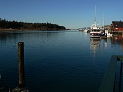
[[File:La Conner 32218.JPG|right|thumb|View north from [[La Conner, Washington|La Conner]] of the Swinomish Channel]] |
[[File:La Conner 32218.JPG|250px|right|thumb|View north from [[La Conner, Washington|La Conner]] of the Swinomish Channel]] |
||
The '''Swinomish Channel''' |
The '''Swinomish Channel''' is an {{convert|11|mi|km|adj=on}} long<ref name=historylink/> salt-water [[channel (geography)|channel]] in [[Washington (state)|Washington state]], United States, which connects [[Skagit Bay]] to the south and [[Padilla Bay]] to the north, separating [[Fidalgo Island]] from mainland [[Skagit County, Washington|Skagit County]].<ref name=gnis>{{GNIS|1526870|Swinomish Channel}}</ref> The Swinomish Channel is the smallest of the three entrances to [[Puget Sound]]—the other two being [[Deception Pass]] and [[Admiralty Inlet]].<ref>{{GNIS|1507653|Puget Sound}}</ref> |
||
The Swinomish Channel is partly natural and partly [[Dredging|dredged]].<ref name="Kirk1995">{{cite book|last=Kirk|first=Ruth|title=Exploring Washington's Past: A Road Guide to History|url=https://books.google.com/books?id=BNAYPXb22sYC&pg=PA236|accessdate=9 August 2013|year=1995|publisher=University of Washington Press|isbn=978-0-295-97443-9|page=236}}</ref> Before being dredged, it was a collection of shallow tidal [[Slough (hydrology)|sloughs]], [[salt marsh]]es, and [[mudflat]]s known as Swinomish Slough. The [[United States Army Corps of Engineers]] used dredging and diking to create a navigable channel, completed in 1937 during the [[Great Depression]].<ref name="Kirk1995"/> |
|||
The channel is notable as being the location where [[Springer (orca)|Springer]], an orphaned [[Southern Resident Killer Whale|Southern Resident]] [[Killer Whale]] was originally sighted. |
|||
The channel is heavily used by fishing boats, tugs, recreational craft, and shallow-draft freight vessels.<ref name=historylink>{{cite web |url= http://www.historylink.org/index.cfm?DisplayPage=output.cfm&File_Id=5655 |title= LaConner -- Thumbnail History |publisher= HistoryLink |accessdate= 9 August 2013}}</ref> |
|||
To maintain navigable depths, the Swinomish Channel must be dredged at least every three years. Dedicated federal funding for continued dredging was eliminated in the 1990s. A study in 2004–2008 determined that sedimentation would render the channel's north end impassable for virtually all vessels by 2015, and its south end by 2019. The channel was dredged again in 2008. In 2012 the Army Corps of Engineers received funding from Congress for another dredging project, which was finished in January 2013.<ref>{{cite web |url= http://www.portofskagit.com/media-center/news/swinomish-channel-to-be-dredged-this-year/ |title= Swinomish Channel to be Dredged This Year |publisher= Port of Skagit |accessdate= 9 August 2013}}</ref><ref>{{cite web |url= http://www.portofskagit.com/la-conner-marina/swinomish-channel-watch/ |title= Swinomish Channel Watch |publisher= Port of Skagit |accessdate= 9 August 2013}}</ref> The channel was most recently dredged in 2018.<ref>{{cite web |url=https://www.goskagit.com/news/local_news/swinomish-channel-dredging-to-begin/article_40d50db5-b1e8-5751-b348-0bb3d8cca65d.html|title=Swinomish Channel dredging to begin|publisher=Skagit Valley Herald}}</ref> |
|||
==References== |
==References== |
||
{{Reflist|30em}} |
|||
<references/> |
|||
{{Authority control}} |
|||
{{Coord|48|24|43|N|122|29|52|W|region:US-WA_type:waterbody_source:GNIS|display=title}} |
{{Coord|48|24|43|N|122|29|52|W|region:US-WA_type:waterbody_source:GNIS|display=title}} |
||
[[Category:Channels of the United States]] |
[[Category:Channels of the United States]] |
||
[[Category: |
[[Category:Bodies of water of Skagit County, Washington]] |
||
[[Category:Bodies of water of Washington (state)]] |
[[Category:Bodies of water of Washington (state)]] |
||
[[Category:Washington placenames of Native American origin]] |
|||
{{ |
{{SkagitCountyWA-geo-stub}} |
||
Latest revision as of 20:51, 24 March 2023

The Swinomish Channel is an 11-mile (18 km) long[1] salt-water channel in Washington state, United States, which connects Skagit Bay to the south and Padilla Bay to the north, separating Fidalgo Island from mainland Skagit County.[2] The Swinomish Channel is the smallest of the three entrances to Puget Sound—the other two being Deception Pass and Admiralty Inlet.[3]
The Swinomish Channel is partly natural and partly dredged.[4] Before being dredged, it was a collection of shallow tidal sloughs, salt marshes, and mudflats known as Swinomish Slough. The United States Army Corps of Engineers used dredging and diking to create a navigable channel, completed in 1937 during the Great Depression.[4]
The channel is heavily used by fishing boats, tugs, recreational craft, and shallow-draft freight vessels.[1]
To maintain navigable depths, the Swinomish Channel must be dredged at least every three years. Dedicated federal funding for continued dredging was eliminated in the 1990s. A study in 2004–2008 determined that sedimentation would render the channel's north end impassable for virtually all vessels by 2015, and its south end by 2019. The channel was dredged again in 2008. In 2012 the Army Corps of Engineers received funding from Congress for another dredging project, which was finished in January 2013.[5][6] The channel was most recently dredged in 2018.[7]
References
[edit]- ^ a b "LaConner -- Thumbnail History". HistoryLink. Retrieved 9 August 2013.
- ^ U.S. Geological Survey Geographic Names Information System: Swinomish Channel
- ^ U.S. Geological Survey Geographic Names Information System: Puget Sound
- ^ a b Kirk, Ruth (1995). Exploring Washington's Past: A Road Guide to History. University of Washington Press. p. 236. ISBN 978-0-295-97443-9. Retrieved 9 August 2013.
- ^ "Swinomish Channel to be Dredged This Year". Port of Skagit. Retrieved 9 August 2013.
- ^ "Swinomish Channel Watch". Port of Skagit. Retrieved 9 August 2013.
- ^ "Swinomish Channel dredging to begin". Skagit Valley Herald.
