
Franklin, Mississippi: Difference between revisions
Magnolia677 (talk | contribs) Expanding article |
→top: add "use mdy dates" template |
||
| (23 intermediate revisions by 12 users not shown) | |||
| Line 1: | Line 1: | ||
{{Use mdy dates|date=July 2023}} |
|||
{{Infobox settlement |
{{Infobox settlement |
||
|official_name = Franklin, Mississippi |
|official_name = Franklin, Mississippi |
||
| Line 6: | Line 7: | ||
<!-- Images --> |
<!-- Images --> |
||
|image_skyline = |
|image_skyline = Franklin Church, Franklin, Mississippi (1938).jpg |
||
|imagesize = |
|imagesize = |
||
|image_caption = |
|image_caption = Franklin Church, built 1841 |
||
|image_flag = |
|image_flag = |
||
|image_seal = |
|image_seal = |
||
| Line 19: | Line 20: | ||
|mapsize1 = |
|mapsize1 = |
||
|map_caption1 = |
|map_caption1 = |
||
|pushpin_map=Mississippi |
|pushpin_map=Mississippi#USA |
||
|pushpin_label = Franklin |
|||
<!-- Location --> |
<!-- Location --> |
||
| ⚫ | |||
|coordinates_region = US-MS |
|||
|subdivision_name = United States |
|||
| ⚫ | |||
| |
|subdivision_type1 = [[U.S. state|State]] |
||
|subdivision_type1 = [[Political divisions of the United States|State]] |
|||
|subdivision_name1 = [[Mississippi]] |
|subdivision_name1 = [[Mississippi]] |
||
|subdivision_type2 = [[List of counties in Mississippi|County]] |
|subdivision_type2 = [[List of counties in Mississippi|County]] |
||
| Line 66: | Line 67: | ||
|elevation_m = |
|elevation_m = |
||
|elevation_ft = 331 |
|elevation_ft = 331 |
||
|coordinates = {{coord|33|02|09|N|90|00|07|W|region:US-MS|display=inline,title}} |
|||
|latd = 33 | |
|||
latm = 02 | |
|||
lats = 09 | |
|||
latNS = N | |
|||
longd = 90 | |
|||
longm = 00 | |
|||
longs = 07 | |
|||
longEW = W | |
|||
coordinates_display=% |
|||
<!-- Area/postal codes & others --> |
<!-- Area/postal codes & others --> |
||
| Line 81: | Line 74: | ||
|area_code = [[Area code 662|662]] |
|area_code = [[Area code 662|662]] |
||
|blank_name = [[Geographic Names Information System|GNIS]] feature ID |
|blank_name = [[Geographic Names Information System|GNIS]] feature ID |
||
|blank_info = 670157<ref>{{gnis|670157}}</ref> |
|blank_info = 670157<ref name=GNIS1>{{gnis|670157|Franklin}}</ref> |
||
|blank1_name = |
|blank1_name = |
||
|blank1_info = |
|blank1_info = |
||
| Line 88: | Line 81: | ||
}} |
}} |
||
'''Franklin''' is an [[Unincorporated area|unincorporated community]] located in [[Holmes County, Mississippi|Holmes County]], [[Mississippi]]. |
'''Franklin''' is an [[Unincorporated area|unincorporated community]] located in [[Holmes County, Mississippi|Holmes County]], [[Mississippi]].<ref name=GNIS1/> [[Mississippi Highway 17]] passes through Franklin, which is approximately {{convert|7|mi|km}} south of [[Lexington, Mississippi|Lexington]], the county seat, and approximately {{convert|12|mi|km}} north of the town of [[Pickens, Mississippi|Pickens]]. |
||
This was long an area of cotton plantations. In the antebellum era, labor was provided by thousands of enslaved African Americans. After the war, many [[freedmen]] continued to work the land as [[sharecroppers]] and [[tenant farmers]]. |
|||
==History== |
==History== |
||
| ⚫ | In 1900 |
||
Franklin was an early place of European-American settlement and developing cotton plantations from the 1830s, when most of the [[Choctaw people]] were [[Indian Removal|removed]] to [[Indian Territory]] west of the Mississippi River. The American migrants were mostly from planter families in South Carolina and Virginia, and brought numerous slaves with them. Others they bought through the domestic slave trade to develop their extensive lands for cotton plantations. |
|||
Located a short distance east of the settlement is the Franklin Church and Cemetery.<ref name=GNIS2>{{cite gnis|670161|Franklin Church}}</ref> Erected in 1841 from labor by enslaved African Americans, the church had two front entrances, one for men and one for women.<ref name="PHMA">{{cite web | title = Pictorial History: Mississippi in Architecture | publisher = W.P.A. Historical Research Project | date = 1938 | url = https://www.flickr.com/photos/mississippi-dept-of-archives-and-history/19107814610/}}</ref> |
|||
On January 2, 1865, during the Civil War, this was a battlefield in an engagement involving 3,300 Federal mounted troops and 1,100 [[Confederate Home Guard]]s led by General [[William Wirt Adams]]. The Union Army won this battle and took numerous prisoners.<ref name="PHMA"/><ref name="NPS">{{cite web | title = Historic Places Not On the National Register | publisher = United States National Park Service | url = https://parkplanning.nps.gov/showFile.cfm?projectID=48304&MIMEType=application%252Fpdf&filename=Inventory_-_Historic_Sites_not_on_National_Register.pdf&sfid=170744 }}</ref> The Franklin Presbyterian Church is still in use; its congregation has decided to keep the cannonball holes from the Civil War left visible as a reminder of its history.<ref name="NPS"/> |
|||
| ⚫ | In 1900 the white population was 80, and the settlement had a post office in the early 1900s.<ref name="Rowland">{{cite book | last = Rowland | first = Dunbar | title = Mississippi: Comprising Sketches of Counties, Towns, Events, Institutions, and Persons, Arranged in Cyclopedic Form | publisher = Southern Historical Publishing Association | year = 1907 | url = https://archive.org/details/mississippicomp01rowlgoog | volume = 1 | page = [https://archive.org/details/mississippicomp01rowlgoog/page/n748 742]}}</ref> |
||
A post office operated under the name Franklin from 1831 to 1906.<ref>{{cite web | url=https://www.postalhistory.com/postoffices.asp?task=display&state=MS&county=Holmes | title=Holmes County | publisher=Jim Forte Postal History | accessdate=2 June 2021}}</ref> |
|||
==References== |
==References== |
||
| Line 97: | Line 101: | ||
{{Holmes County, Mississippi}} |
{{Holmes County, Mississippi}} |
||
{{authority control}} |
|||
[[Category:Unincorporated communities in Holmes County, Mississippi]] |
[[Category:Unincorporated communities in Holmes County, Mississippi]] |
||
[[Category:Unincorporated communities in Mississippi]] |
[[Category:Unincorporated communities in Mississippi]] |
||
[[Category:Battles of the American Civil War in Mississippi]] |
|||
{{ |
{{HolmesCountyMS-geo-stub}} |
||
Latest revision as of 05:26, 25 July 2023
Franklin, Mississippi | |
|---|---|
.jpg) Franklin Church, built 1841 | |
 Franklin  Franklin | |
| Coordinates: 33°02′09″N 90°00′07″W / 33.03583°N 90.00194°W | |
| Land | Vereinigte Staaten |
| State | Mississippi |
| County | Holmes |
| Elevation | 331 ft (101 m) |
| Time zone | UTC-6 (Central (CST)) |
| • Summer (DST) | UTC-5 (CDT) |
| ZIP code | 39095 |
| Area code | 662 |
| GNIS feature ID | 670157[1] |
Franklin is an unincorporated community located in Holmes County, Mississippi.[1] Mississippi Highway 17 passes through Franklin, which is approximately 7 miles (11 km) south of Lexington, the county seat, and approximately 12 miles (19 km) north of the town of Pickens.
This was long an area of cotton plantations. In the antebellum era, labor was provided by thousands of enslaved African Americans. After the war, many freedmen continued to work the land as sharecroppers and tenant farmers.
History
[edit]Franklin was an early place of European-American settlement and developing cotton plantations from the 1830s, when most of the Choctaw people were removed to Indian Territory west of the Mississippi River. The American migrants were mostly from planter families in South Carolina and Virginia, and brought numerous slaves with them. Others they bought through the domestic slave trade to develop their extensive lands for cotton plantations.
Located a short distance east of the settlement is the Franklin Church and Cemetery.[2] Erected in 1841 from labor by enslaved African Americans, the church had two front entrances, one for men and one for women.[3]
On January 2, 1865, during the Civil War, this was a battlefield in an engagement involving 3,300 Federal mounted troops and 1,100 Confederate Home Guards led by General William Wirt Adams. The Union Army won this battle and took numerous prisoners.[3][4] The Franklin Presbyterian Church is still in use; its congregation has decided to keep the cannonball holes from the Civil War left visible as a reminder of its history.[4]
In 1900 the white population was 80, and the settlement had a post office in the early 1900s.[5]
A post office operated under the name Franklin from 1831 to 1906.[6]
References
[edit]- ^ a b U.S. Geological Survey Geographic Names Information System: Franklin
- ^ "Franklin Church". Geographic Names Information System. United States Geological Survey, United States Department of the Interior.
- ^ a b "Pictorial History: Mississippi in Architecture". W.P.A. Historical Research Project. 1938.
- ^ a b "Historic Places Not On the National Register". United States National Park Service.
- ^ Rowland, Dunbar (1907). Mississippi: Comprising Sketches of Counties, Towns, Events, Institutions, and Persons, Arranged in Cyclopedic Form. Vol. 1. Southern Historical Publishing Association. p. 742.
- ^ "Holmes County". Jim Forte Postal History. Retrieved June 2, 2021.
Municipalities and communities of Holmes County, Mississippi, United States | ||
|---|---|---|
| Cities | 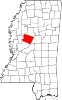 | |
| Towns | ||
| Unincorporated communities | ||
| Ghost town | ||
This Holmes County, Mississippi state location article is a stub. You can help Wikipedia by expanding it. |