
High Falls State Park: Difference between revisions
m Robot - Moving category Georgia (U.S. state) state parks to Category:State parks of Georgia (U.S. state) per CFD at Wikipedia:Categories for discussion/Log/2013 February 25. |
→top: add "use mdy dates" template |
||
| (24 intermediate revisions by 19 users not shown) | |||
| Line 1: | Line 1: | ||
{{Use mdy dates|date=August 2023}} |
|||
[[Image:Picture 881.jpg|right|thumbnail|200px|High Falls]] |
|||
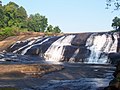
'''High Falls State Park''' is a {{convert|1050|acre|sqkm|adj=on}} [[state park]] located near the city of [[Jackson, Georgia|Jackson]] in [[Monroe County, Georgia]]. It is the site of a prosperous 19th-century industrial center, which became a [[ghost town]] when it was bypassed by the railroad.<ref>{{cite book | url=http://www.kenkrakow.com/gpn/h.pdf | title=Georgia Place-Names: Their History and Origins | publisher=Winship Press | author=Krakow, Kenneth K. | year=1975 | location=Macon, GA | pages=108 | isbn=0-915430-00-2}}</ref> The park contains the largest waterfall in middle Georgia and a {{convert|650|acre|sqkm|adj=on}} lake. |
|||
| ⚫ | |||
[[File:High Falls State Park in Georgia. Summer 2019.jpg|thumb|]] |
|||
| ⚫ | |||
==History== |
|||
| ⚫ | In the early 19th century, the park's land was a prosperous industrial town with several stores, a [[grist mill]], [[cotton gin]], [[blacksmith]] shop, and shoe factory. However, the town, called High Falls, became a [[ghost town]] in the 1880s when it was bypassed by a major [[railroad]]. The remains of the bridge on Old Alabama Road still partially stand to offer views of the shoals below the dam. The bridge, constructed in 1890, was mostly destroyed in the flood of 1994. The park's trails offer visitors scenic views of the largest [[waterfall]] in middle Georgia on the [[Towaliga River]], cascading over {{convert|135|ft}} to the base. Historic hikes lead to the foundation of the old grist mill and ruins of the old powerhouse. The park contains a {{convert|650|acre|sqkm|adj=on}} lake. |
||
==Facilities== |
==Facilities== |
||
* |
*97 tent/trailer/[[RV]] Campsites |
||
*5 picnic shelters |
*5 picnic shelters |
||
*1 Paddle-In Primitive Campsite |
|||
*Group shelter |
*1 Group shelter |
||
*Pioneer |
*1 Pioneer Campground |
||
*[[Miniature golf]] course |
*[[Miniature golf]] course |
||
*[[Swimming pool]] |
*[[Swimming pool]] |
||
*3 hiking trails |
|||
==Annual events== |
==Annual events== |
||
| Line 17: | Line 20: | ||
*Forsythia Festival Crappie Tournament (March) |
*Forsythia Festival Crappie Tournament (March) |
||
== |
==Popular culture== |
||
Dickey Betts of [[The Allman Brothers Band]] wrote an instrumental titled "High Falls" |
[[Dickey Betts]] of [[The Allman Brothers Band]] wrote an instrumental titled "High Falls", named after the park, that came out in 1975.<ref>Freeman, Scott. ''Midnight Riders: The Story of the Allman Brothers Band'', Little, Brown & Co., 1995, p. 200.</ref> The recording is 14½ minutes long. |
||
==Park information== |
|||
The park is open from 7:00 a.m. to 10:00 p.m. and the office is open from 8 p.m. until 5 p.m. |
|||
The park is free for the community, parking is $5 and there are annual passes that can be purchased. The address to easily get to the park using your GPS is 76 High Falls Park Drive, [[Jackson, Georgia]], 30233. |
|||
==Images== |
|||
<gallery> |
|||
Image:High Falls on the Towaliga River, High Falls State Park, Georgia.jpg|High Falls |
|||
Image:High falls ga.jpg|High Falls |
|||
| ⚫ | |||
Image:High falls dam.jpg|High Falls Dam |
|||
Image:High falls powerhouse.jpg|Remains of powerhouse |
|||
Image:16 11 209 high falls.jpg|Picnic tables overlooking High Falls Lake |
|||
</gallery> |
|||
==References== |
|||
| ⚫ | |||
{{Reflist}} |
|||
==External links== |
==External links== |
||
*[ |
*[https://gastateparks.org/HighFalls High Falls State Park] |
||
*[http://www.atlantatrails.com/hiking-trails/high-falls-state-park-falls-trail/ High Falls State Park Hiking] |
|||
{{Georgia state parks}} |
{{Georgia state parks}} |
||
{{Authority control}} |
|||
{{Coord|33.18123|-84.01602|type:landmark_region:US-GA|display=title}} |
|||
| ⚫ | |||
[[Category:State parks of Georgia (U.S. state)]] |
[[Category:State parks of Georgia (U.S. state)]] |
||
[[Category:Protected areas of |
[[Category:Protected areas of Monroe County, Georgia]] |
||
Latest revision as of 22:19, 1 August 2023
High Falls State Park is a 1,050-acre (4.2 km2) state park located near the city of Jackson in Monroe County, Georgia. It is the site of a prosperous 19th-century industrial center, which became a ghost town when it was bypassed by the railroad.[1] The park contains the largest waterfall in middle Georgia and a 650-acre (2.6 km2) lake.

History
[edit]In the early 19th century, the park's land was a prosperous industrial town with several stores, a grist mill, cotton gin, blacksmith shop, and shoe factory. However, the town, called High Falls, became a ghost town in the 1880s when it was bypassed by a major railroad. The remains of the bridge on Old Alabama Road still partially stand to offer views of the shoals below the dam. The bridge, constructed in 1890, was mostly destroyed in the flood of 1994. The park's trails offer visitors scenic views of the largest waterfall in middle Georgia on the Towaliga River, cascading over 135 feet (41 m) to the base. Historic hikes lead to the foundation of the old grist mill and ruins of the old powerhouse. The park contains a 650-acre (2.6 km2) lake.
Facilities
[edit]- 97 tent/trailer/RV Campsites
- 5 picnic shelters
- 1 Paddle-In Primitive Campsite
- 1 Group shelter
- 1 Pioneer Campground
- Miniature golf course
- Swimming pool
Annual events
[edit]- Canoe trips
- Forsythia Festival Crappie Tournament (March)
Popular culture
[edit]Dickey Betts of The Allman Brothers Band wrote an instrumental titled "High Falls", named after the park, that came out in 1975.[2] The recording is 14½ minutes long.
Park information
[edit]The park is open from 7:00 a.m. to 10:00 p.m. and the office is open from 8 p.m. until 5 p.m. The park is free for the community, parking is $5 and there are annual passes that can be purchased. The address to easily get to the park using your GPS is 76 High Falls Park Drive, Jackson, Georgia, 30233.
Images
[edit]-
 High Falls
 -
 High Falls
 -
 Lake at High Falls
 -
 High Falls Dam
 -
 Remains of powerhouse
 -
 Picnic tables overlooking High Falls Lake


References
[edit]- ^ Krakow, Kenneth K. (1975). Georgia Place-Names: Their History and Origins (PDF). Macon, GA: Winship Press. p. 108. ISBN 0-915430-00-2.
- ^ Freeman, Scott. Midnight Riders: The Story of the Allman Brothers Band, Little, Brown & Co., 1995, p. 200.