Llancarfan: Difference between revisions
m Bot: Migrating 5 interwiki links, now provided by Wikidata on d:q1027137 (Report Errors) |
No edit summary Tags: Mobile edit Mobile web edit |
||
| (36 intermediate revisions by 29 users not shown) | |||
| Line 1: | Line 1: | ||
{{Use dmy dates|date=October 2019}} |
|||
{{ |
{{Infobox UK place |
||
|country = Wales |
| country = Wales |
||
|static_image_name |
| static_image_name = Llancarfan, St Cadoc (35873785235).jpg |
||
|static_image_caption |
| static_image_caption = The parish church of Saint Cadoc |
||
|latitude= 51.417 |
|||
| coordinates = {{coord|51.4242|-3.3656|display=inline,title}} |
|||
|longitude=-3.367 |
|||
|official_name =Llancarfan |
| official_name = Llancarfan |
||
|population |
| population = 747 |
||
|population_ref |
| population_ref = ''(2011)'' |
||
|community_wales |
| community_wales = Llancarfan |
||
|unitary_wales=[[Vale of Glamorgan]] |
| unitary_wales = [[Vale of Glamorgan]] |
||
| lieutenancy_wales = [[South Glamorgan]] |
|||
|constituency_westminster= |
|||
| constituency_westminster = [[Vale of Glamorgan (UK Parliament constituency)|Vale of Glamorgan]] |
|||
|post_town= Barry |
|||
| constituency_welsh_assembly = [[Vale of Glamorgan (Senedd constituency)|Vale of Glamorgan]] |
|||
| ⚫ | |||
| post_town = BARRY |
|||
| ⚫ | |||
| ⚫ | |||
|dial_code= |
|||
| post_town1 = COWBRIDGE |
|||
| ⚫ | |||
| postcode_district1 = CF71 |
|||
| ⚫ | |||
| postcode_area1 = CF |
|||
| dial_code = |
|||
| ⚫ | |||
}} |
}} |
||
'''Llancarfan''' is a rural |
'''Llancarfan''' is a rural village and [[community (Wales)|community]] in the [[Vale of Glamorgan]], Wales. The village, located west of [[Barry, Vale of Glamorgan|Barry]] and near [[Cowbridge]], has a well-known [[parish church]], the site of Saint [[Cadoc]]'s 6th-century [[Clas (ecclesiastical settlement)|clas]], famed for its learning. [[Cainnech of Aghaboe]], [[Caradoc of Llancarfan]] and many other [[Welsh people|Welsh]] holy men studied there. Antiquarian [[Iolo Morganwg]] was born in the hamlet of Pen-onn near Llancarfan. At the 2001 census, the community had a population of 736.<ref>{{cite web|title=Parish Headcounts: Llancarfan|url=http://www.neighbourhood.statistics.gov.uk/dissemination/viewFullDataset.do?instanceSelection=03070&productId=779&$ph=60_61&datasetInstanceId=3070&startColumn=1&numberOfColumns=8&containerAreaId=790572|work=Neighbourhood Statistics|publisher=Office for National Statistics|access-date=23 December 2012}}</ref> In the 2011 census, the population was 747.<ref>{{Cite web|url=https://www.nomisweb.co.uk/reports/localarea?compare=W04000655|title=Custom report - Nomis - Official Labour Market Statistics|accessdate=3 August 2023}}</ref> Most of the village lies within a conservation area designated by the local authority in 1971. Buildings listed as being of special historic interest include The Fox and Hounds [[public house]], the former Bethlehem Chapel, the former Wesleyan Chapel, Chapel Cottage, Great House, Corner House and Llancarfan Primary School.<ref>{{cite web|title=Parish Headcounts: Llancarfan|url=http://www.valeofglamorgan.gov.uk/en/living/planning_and_building_control/planning_policy/conservation_areas/llancarfan.aspx|publisher=Vale of Glamorgan Council|access-date=5 May 2016}}</ref> The community includes village of [[Moulton, Vale of Glamorgan|Moulton]]. |
||
The spacious church, which in the later [[Middle Ages]] belonged to [[Gloucester Abbey]], contains a [[stoup]] and interesting remains of a [[rood screen]], now adapted as a [[reredos]]. In early 2008, [[architects]] discovered [[medieval]] [[wall painting]] in the church under layers of [[whitewash]], including one of only three depictions of [[St George]] to be found in churches in Wales. [[Conservation-restoration]] work |
The spacious church, which in the later [[Middle Ages]] belonged to [[Gloucester Abbey]], contains a [[stoup]] and interesting remains of a [[rood screen]], now adapted as a [[reredos]]. In early 2008, [[architects]] discovered [[medieval]] [[wall painting]] in the church under layers of [[whitewash]], including one of only three depictions of [[St George]] to be found in churches in Wales. [[Conservation-restoration]] work to reveal the entire mural was completed in 2013.<ref>{{cite web|url=https://www.bbc.co.uk/news/uk-wales-25374914|title=15th Century paintings unveiled to public in Llancarfan|date=13 December 2013|work=BBC}}</ref> |
||
The community forms half of the [[Rhoose (electoral ward)|Rhoose]] [[electoral ward]] for elections to the [[Vale of Glamorgan Council]]. |
|||
==References== |
==References== |
||
| Line 26: | Line 33: | ||
==External links== |
==External links== |
||
{{Commons category|Llancarfan}} |
|||
*[http://www.stcadocs.org.uk St Cadoc's Church, Llancarfan] |
|||
*[http://www.llancarfansociety.org.uk Llancarfan Society Web Page] |
*[http://www.llancarfansociety.org.uk Llancarfan Society Web Page] |
||
| ⚫ | |||
{{ValeofGlamorgan-geo-stub}} |
|||
{{Vale of Glamorgan}} |
{{Vale of Glamorgan}} |
||
{{Authority control}} |
|||
| ⚫ | |||
[[Category:Communities in the Vale of Glamorgan]] |
|||
Latest revision as of 15:46, 4 August 2023
| Llancarfan | |
|---|---|
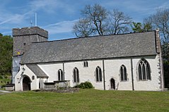
 The parish church of Saint Cadoc | |
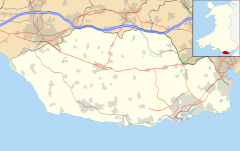
Location within the Vale of Glamorgan | |
| Population | 747 (2011) |
| OS grid reference | ST051701 |
| Community |
|
| Principal area | |
| Preserved county | |
| Country | Wales |
| Sovereign state | United Kingdom |
| Post town | BARRY |
| Postcode district | CF62 |
| Post town | COWBRIDGE |
| Postcode district | CF71 |
| Police | South Wales |
| Fire | South Wales |
| Ambulance | Welsh |
| UK Parliament | |
| Senedd Cymru – Welsh Parliament | |
Llancarfan is a rural village and community in the Vale of Glamorgan, Wales. The village, located west of Barry and near Cowbridge, has a well-known parish church, the site of Saint Cadoc's 6th-century clas, famed for its learning. Cainnech of Aghaboe, Caradoc of Llancarfan and many other Welsh holy men studied there. Antiquarian Iolo Morganwg was born in the hamlet of Pen-onn near Llancarfan. At the 2001 census, the community had a population of 736.[1] In the 2011 census, the population was 747.[2] Most of the village lies within a conservation area designated by the local authority in 1971. Buildings listed as being of special historic interest include The Fox and Hounds public house, the former Bethlehem Chapel, the former Wesleyan Chapel, Chapel Cottage, Great House, Corner House and Llancarfan Primary School.[3] The community includes village of Moulton.
The spacious church, which in the later Middle Ages belonged to Gloucester Abbey, contains a stoup and interesting remains of a rood screen, now adapted as a reredos. In early 2008, architects discovered medieval wall painting in the church under layers of whitewash, including one of only three depictions of St George to be found in churches in Wales. Conservation-restoration work to reveal the entire mural was completed in 2013.[4]
The community forms half of the Rhoose electoral ward for elections to the Vale of Glamorgan Council.
References
[edit]- ^ "Parish Headcounts: Llancarfan". Neighbourhood Statistics. Office for National Statistics. Retrieved 23 December 2012.
- ^ "Custom report - Nomis - Official Labour Market Statistics". Retrieved 3 August 2023.
- ^ "Parish Headcounts: Llancarfan". Vale of Glamorgan Council. Retrieved 5 May 2016.
- ^ "15th Century paintings unveiled to public in Llancarfan". BBC. 13 December 2013.


