
Pool Malebo: Difference between revisions
m →History: add name of town where plaque is |
No edit summary Tags: Mobile edit Mobile web edit |
||
| (15 intermediate revisions by 10 users not shown) | |||
| Line 1: | Line 1: | ||
{{Short description|Widening of the Congo River; part of the border between the R Congo and the DR Congo}} |
|||
{{refimprove|date=June 2011}} |
|||
{{Infobox |
{{Infobox body of water |
||
| name = Pool Malebo |
| name = Pool Malebo |
||
| image = Kinshasa & Brazzaville - ISS007-E-6305.jpg |
| image = Kinshasa & Brazzaville - ISS007-E-6305.jpg |
||
| Line 21: | Line 21: | ||
| residence_time = |
| residence_time = |
||
| shore = |
| shore = |
||
| elevation = {{convert| |
| elevation = {{convert|270|m|abbr=on}} |
||
| islands = [[Mbamu]] |
| islands = [[Mbamu]] |
||
| islands_category = |
| islands_category = |
||
| cities = [[Brazzaville]], [[Kinshasa]] |
| cities = [[Brazzaville]], [[Kinshasa]] |
||
<!-- Map --> |
<!-- Map --> |
||
| pushpin_map = Democratic Republic of the Congo# |
| pushpin_map = Democratic Republic of the Congo#Republic of the Congo |
||
| pushpin_label_position = |
| pushpin_label_position = |
||
| pushpin_map_alt = Location of Pool Malebo in Democratic Republic of the Congo. |
| pushpin_map_alt = Location of Pool Malebo in Democratic Republic of the Congo. |
||
| Line 34: | Line 34: | ||
| reference = |
| reference = |
||
}} |
}} |
||
| ⚫ | The '''Pool Malebo''', formerly '''Stanley Pool''', also known as '''Lake Nkunda''' by local indigenous people in pre-colonial times |
||
| ⚫ | The '''Pool Malebo''', formerly '''Stanley Pool''', also known as '''Mpumbu''', '''Lake Nkunda''' or '''Lake Nkuna''' by local indigenous people in [[Pre-colonial history of the Democratic Republic of the Congo|pre-colonial times]],<ref>William Graham Lister Randles, ''L’ancien royaume du Congo des origines à la fin du XIXe siècle'', Éditions de l’École des hautes études en sciences sociales, 2013, p. 44</ref><ref>Sylvie Ayimpam, ''Vie matérielle, échanges et capitalisme sur la rive méridionale du Pool du fleuve Congo (1815-1930)'', Centre d’Étude des Mondes Africains (CEMAf), 2006, p. 4</ref> is a lake-like widening in the lower reaches of the [[Congo River]].<ref name="britannica">[http://www.britannica.com/EBchecked/topic/359978/Malebo-Pool "Malebo Pool"]. ''[[Encyclopædia Britannica]]''. Accessed June 2011.</ref> The river serves as the border between the [[Republic of the Congo]] to the north and the [[Democratic Republic of the Congo]] to the south. |
||
| ⚫ | |||
| ⚫ | |||
==History== |
==History== |
||
In the late 19th century, |
In the late 19th century, British colonists named this natural feature Stanley Pool, after British explorer and journalist Henry Morton Stanley, who had mapped and reported on this region. When a railway was constructed nearby, a plaque was installed at Palaba to commemorate the rail line connecting [[Matadi]] to [[Stanley Pool]].<ref>{{Cite web|url=https://collections.lib.uwm.edu/digital/collection/agsafrica/id/1910/|title=Kongo Central province (Democratic Republic of the Congo), plaque at Palabala commemorating the railway|website=collections.lib.uwm.edu}}</ref> |
||
==Description== |
==Description== |
||
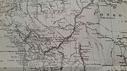
[[File:Stanley pool01.jpg|thumb|upright=1.3|Map of Stanley Pool]] |
[[File:Stanley pool01.jpg|thumb|upright=1.3|Map of Stanley Pool]] |
||
The Pool Malebo is about 35 |
The Pool Malebo is about {{convert|35|km}} long, {{convert|23|km}} wide and {{convert|500|km2|abbr=on}} in [[surface area]]. Its central part is occupied by [[M'Bamou]] or Bamu Island<ref name="britannica"/> ({{convert|180|km2|abbr=on}}), which is [[Republic of the Congo]] territory. |
||
The pool is shallow with depths of 3–10 m. But water levels may vary by as much as 3 m over the course of a year, because of seasonal flooding. The altitude here is an average of 272 |
The pool is shallow with depths of 3–10 m. But water levels may vary by as much as 3 m over the course of a year, because of seasonal flooding. The altitude here is an average of {{convert|272|m}}.<!-- Why talk about altitude? Because of river valley? --> |
||
==Geography== |
==Geography== |
||
| Line 56: | Line 57: | ||
===Flora=== |
===Flora=== |
||
There are many [[palm]] and [[papyrus]] swamps along the edges of the river and pool. Floating mats of ''[[Eichhornia]]'' plants move on the river and drift through the pool.<ref name="ecoregions">[http://www.feow.org/ecoregion_details.php?eco=548 "Malebo Pool"] {{webarchive|url=https://web.archive.org/web/20111005204600/http://www.feow.org/ecoregion_details.php?eco=548 |
There are many [[Arecaceae|palm]] and [[papyrus]] swamps along the edges of the river and pool. Floating mats of ''[[Eichhornia]]'' plants move on the river and drift through the pool.<ref name="ecoregions">[http://www.feow.org/ecoregion_details.php?eco=548 "Malebo Pool"] {{webarchive|url=https://web.archive.org/web/20111005204600/http://www.feow.org/ecoregion_details.php?eco=548|date=2011-10-05}}. [http://www.feow.org "Freshwater Ecoregions of the World"]. [[The Nature Conservancy]]. Accessed June 2011.</ref> |
||
=== |
===Fish=== |
||
====Fish==== |
|||
Most fish endemic to the area are [[catfish]]es, including the [[mountain catfish]], ''L. brieni'', ''[[Leptoglanis mandevillei]]'', ''L. bouilloni'' and ''[[Atopochilus chabanaudi]]'', an [[upside-down catfish]].<ref name="ecoregions"/> More than 200 fish species have been documented. [[Mormyrid]]s are the most common, with over 40 species, and have the highest diversification.<ref name="ecoregions"/> |
Most fish endemic to the area are [[catfish]]es, including the [[mountain catfish]], ''L. brieni'', ''[[Leptoglanis mandevillei]]'', ''L. bouilloni'' and ''[[Atopochilus chabanaudi]]'', an [[upside-down catfish]].<ref name="ecoregions"/> More than 200 fish species have been documented. [[Mormyrid]]s are the most common, with over 40 species, and have the highest diversification.<ref name="ecoregions"/> |
||
<gallery> |
<gallery widths="180px" heights="120px" > |
||
PoolMalebo.jpg|Aerial view of Pool Malebo from above Kinshasa |
PoolMalebo.jpg|Aerial view of Pool Malebo from above Kinshasa |
||
Congo Map by Stanley.jpg|Stanley's route is depicted by the solid black line. |
Congo Map by Stanley.jpg|Stanley's route is depicted by the solid black line. |
||
| Line 73: | Line 72: | ||
==References== |
==References== |
||
{{reflist}} |
|||
| ⚫ | |||
{{Commons category|Pool Malebo}} |
{{Commons category|Pool Malebo}} |
||
{{Reflist}} |
|||
| ⚫ | |||
{{Regions of Africa}} |
{{Regions of Africa}} |
||
{{Authority control}} |
|||
[[Category:Congo River]] |
[[Category:Congo River]] |
||
| Line 86: | Line 85: | ||
[[Category:Ecoregions of the Democratic Republic of the Congo|Malebo]] |
[[Category:Ecoregions of the Democratic Republic of the Congo|Malebo]] |
||
[[Category:Natural pools|Malebo]] |
[[Category:Natural pools|Malebo]] |
||
[[Category:Freshwater ecoregions of Africa]] |
|||
Latest revision as of 11:14, 17 August 2023
| Pool Malebo | |
|---|---|
 Satellite image of the Pool Malebo; the capital cities of Brazzaville, ROC and Kinshasa, DRC are indicated. | |
 Pool Malebo  Pool Malebo | |
| Coordinates | 4°16′55″S 15°29′19″E / 4.28194°S 15.48861°E |
| Lake type | Fluvial |
| Primary inflows | Congo River |
| Primary outflows | Congo River |
| Surface elevation | 270 m (890 ft) |
| Islands | Mbamu |
| Settlements | Brazzaville, Kinshasa |
The Pool Malebo, formerly Stanley Pool, also known as Mpumbu, Lake Nkunda or Lake Nkuna by local indigenous people in pre-colonial times,[1][2] is a lake-like widening in the lower reaches of the Congo River.[3] The river serves as the border between the Republic of the Congo to the north and the Democratic Republic of the Congo to the south.
The pool's former name was in honour of the British explorer and journalist Sir Henry Morton Stanley, who mapped this area.
History
[edit]In the late 19th century, British colonists named this natural feature Stanley Pool, after British explorer and journalist Henry Morton Stanley, who had mapped and reported on this region. When a railway was constructed nearby, a plaque was installed at Palaba to commemorate the rail line connecting Matadi to Stanley Pool.[4]
Description
[edit]
The Pool Malebo is about 35 kilometres (22 mi) long, 23 kilometres (14 mi) wide and 500 km2 (190 sq mi) in surface area. Its central part is occupied by M'Bamou or Bamu Island[3] (180 km2 (69 sq mi)), which is Republic of the Congo territory.
The pool is shallow with depths of 3–10 m. But water levels may vary by as much as 3 m over the course of a year, because of seasonal flooding. The altitude here is an average of 272 metres (892 ft).
Geography
[edit]The capitals of the Republic of the Congo and the Democratic Republic of the Congo —Brazzaville and Kinshasa, respectively— are located on opposite shores of the southern part of Pool Malebo. These two capital cities are the closest geographically of any in the world (other than the contiguous Rome, Italy and Vatican City).
The Pool is the beginning of the navigable part of the Congo River upstream to the cities of Mbandaka, Kisangani and Bangui. Downstream, navigation of the river is blocked by its descent through hundreds of meters in a series of rapids known as the Livingstone Falls.[5]: Vol.Two, 255 The river reaches sea level at the port of Boma, Congo, after a passage of 300 km.
Ecology
[edit]Flora
[edit]There are many palm and papyrus swamps along the edges of the river and pool. Floating mats of Eichhornia plants move on the river and drift through the pool.[6]
Fish
[edit]Most fish endemic to the area are catfishes, including the mountain catfish, L. brieni, Leptoglanis mandevillei, L. bouilloni and Atopochilus chabanaudi, an upside-down catfish.[6] More than 200 fish species have been documented. Mormyrids are the most common, with over 40 species, and have the highest diversification.[6]
-
 Aerial view of Pool Malebo from above Kinshasa
 -
 Stanley's route is depicted by the solid black line.
 -
 View of Stanley Pool from Leopoldville, 1889 (now Kinshasa)


_pg751_Panorama_du_Stanley_Pool.jpg)
See also
[edit]References
[edit]- ^ William Graham Lister Randles, L’ancien royaume du Congo des origines à la fin du XIXe siècle, Éditions de l’École des hautes études en sciences sociales, 2013, p. 44
- ^ Sylvie Ayimpam, Vie matérielle, échanges et capitalisme sur la rive méridionale du Pool du fleuve Congo (1815-1930), Centre d’Étude des Mondes Africains (CEMAf), 2006, p. 4
- ^ a b "Malebo Pool". Encyclopædia Britannica. Accessed June 2011.
- ^ "Kongo Central province (Democratic Republic of the Congo), plaque at Palabala commemorating the railway". collections.lib.uwm.edu.
- ^ Stanley, H.M., 1899, Through the Dark Continent, London: G. Newnes, Vol. One ISBN 0486256677, Vol. Two ISBN 0486256685
- ^ a b c "Malebo Pool" Archived 2011-10-05 at the Wayback Machine. "Freshwater Ecoregions of the World". The Nature Conservancy. Accessed June 2011.
This Republic of the Congo location article is a stub. You can help Wikipedia by expanding it. |
This Democratic Republic of the Congo location article is a stub. You can help Wikipedia by expanding it. |