
Stewartsville, New Jersey: Difference between revisions
Rescuing 2 sources and tagging 0 as dead.) #IABot (v2.0) (GreenC - 5550 |
add notable(s), with source(s) |
||
| (24 intermediate revisions by 9 users not shown) | |||
| Line 1: | Line 1: | ||
{{short description|Populated place in Warren County, New Jersey, US}} |
|||
{{Use American English|date=June 2022}} |
|||
{{Use mdy dates|date=June 2022}} |
|||
{{Infobox settlement |
{{Infobox settlement |
||
|name = Stewartsville, New Jersey |
|name = Stewartsville, New Jersey |
||
| Line 6: | Line 9: | ||
<!-- Images --> |
<!-- Images --> |
||
|image_skyline = |
|image_skyline = North Main Street, Stewartsville, NJ - farmhouse.jpg |
||
|imagesize = |
|imagesize = |
||
|image_caption = |
|image_caption = Hulshizer/Brill farm on North main street built in 1833 |
||
|image_flag = |
|image_flag = |
||
|image_seal = |
|image_seal = |
||
| Line 20: | Line 23: | ||
|map_caption1 = |
|map_caption1 = |
||
|pushpin_map = USA New Jersey Warren County#USA New Jersey#USA |
|pushpin_map = USA New Jersey Warren County#USA New Jersey#USA |
||
|pushpin_label = Stewartsville |
|||
|pushpin_label_position = |
|||
|pushpin_map_caption = Location |
|pushpin_map_caption = Location in [[Warren County, New Jersey|Warren County]]##Location in [[New Jersey]]##Location in the United States |
||
| |
|pushpin_relief = yes |
||
<!-- Location --> |
<!-- Location --> |
||
| Line 34: | Line 37: | ||
|subdivision_name3 = [[Greenwich Township, Warren County, New Jersey|Greenwich]] |
|subdivision_name3 = [[Greenwich Township, Warren County, New Jersey|Greenwich]] |
||
|established_title = |
|established_title = |
||
|established_date = |
|established_date = |
||
|named_for = Thomas Stewart |
|named_for = Thomas Stewart |
||
<!-- Area --> |
<!-- Area --> |
||
|unit_pref = Imperial |
|unit_pref = Imperial |
||
|area_footnotes = <ref name= |
|area_footnotes = <ref name="TigerWebMapServer">{{cite web|title=ArcGIS REST Services Directory|url=https://tigerweb.geo.census.gov/arcgis/rest/services/TIGERweb/Places_CouSub_ConCity_SubMCD/MapServer/5/query?where=STATE='34'&outFields=NAME,STATE,PLACE,AREALAND,AREAWATER,LSADC,CENTLAT,CENTLON&orderByFields=PLACE&returnGeometry=false&returnTrueCurves=false&f=json|publisher=United States Census Bureau|accessdate=October 11, 2022}}</ref> |
||
|area_magnitude = |
|area_magnitude = |
||
|area_total_km2 = |
|area_total_km2 = 2.80 |
||
|area_land_km2 = |
|area_land_km2 = 2.80 |
||
|area_water_km2 = 0. |
|area_water_km2 = 0.00 |
||
|area_total_sq_mi = |
|area_total_sq_mi = 1.08 |
||
|area_land_sq_mi = |
|area_land_sq_mi = 1.08 |
||
|area_water_sq_mi = 0. |
|area_water_sq_mi = 0.00 |
||
|area_water_percent = 0.00 |
|area_water_percent = 0.00 |
||
<!-- Population --> |
<!-- Population --> |
||
|population_as_of = [[ |
|population_as_of = [[2020 United States census|2020]] |
||
|population_footnotes = <ref name="USCensusDecennial2020CenPopScriptOnly"/> |
|||
|population_footnotes = <ref name=Census2010>[http://factfinder.census.gov/bkmk/table/1.0/en/DEC/10_DP/DPDP1/1600000US3470800 DP-1 - Profile of General Population and Housing Characteristics: 2010 Demographic Profile Data for Stewartsville CDP, New Jersey], [[United States Census Bureau]]. Accessed June 3, 2013.</ref> |
|||
|population_total = |
|population_total = 636 |
||
|population_density_km2 = |
|population_density_km2 = 226.98 |
||
|population_density_sq_mi = |
|population_density_sq_mi = 587.80 |
||
<!-- General information --> |
<!-- General information --> |
||
|timezone = [[Eastern Time Zone|Eastern (EST)]] |
|timezone = [[Eastern Time Zone|Eastern (EST)]] |
||
|utc_offset = |
|utc_offset = −05:00 |
||
|timezone_DST = [[Eastern Time Zone|EDT]] |
|timezone_DST = [[Eastern Time Zone|EDT]] |
||
|utc_offset_DST = |
|utc_offset_DST = −04:00 |
||
|elevation_footnotes = <ref |
|elevation_footnotes = <ref name=GNIS/> |
||
|elevation_m = 96 |
|elevation_m = 96 |
||
|elevation_ft = 315 |
|elevation_ft = 315 |
||
|coordinates_footnotes = <ref name= |
|coordinates_footnotes = <ref name=GNIS/><ref name="GR1">[https://www.census.gov/geographies/reference-files/time-series/geo/gazetteer-files.html US Gazetteer files: 2010, 2000, and 1990], [[United States Census Bureau]]. Accessed September 4, 2014.</ref> |
||
|coordinates = {{coord|40 |
|coordinates = {{coord|40|41|38|N|75|6|41|W|region:US_type:city|display=inline,title}} |
||
<!-- Area/postal codes & others --> |
<!-- Area/postal codes & others --> |
||
|postal_code_type = [[ZIP |
|postal_code_type = [[ZIP Code]] |
||
|postal_code = 08886<ref name=USPS>[http://tools.usps.com/go/ZipLookupResultsAction!input.action?resultMode=0&city=stewartsville&state=NJ Look Up a ZIP Code for Stewartsville, NJ], [[United States Postal Service]]. Accessed June 3, 2013.</ref> |
|postal_code = 08886<ref name=USPS>[http://tools.usps.com/go/ZipLookupResultsAction!input.action?resultMode=0&city=stewartsville&state=NJ Look Up a ZIP Code for Stewartsville, NJ], [[United States Postal Service]]. Accessed June 3, 2013.</ref> |
||
|area_code = [[Area code 908|908]] |
|area_code = [[Area code 908|908]] |
||
|blank_name = [[Federal Information Processing Standards|FIPS code]] |
|blank_name = [[Federal Information Processing Standards|FIPS code]] |
||
|blank_info = |
|blank_info = {{FIPS|34|70800}}<ref name=CensusArea>[http://www2.census.gov/geo/docs/maps-data/data/gazetteer/2010_place_list_34.txt Gazetteer of New Jersey Places], [[United States Census Bureau]]. Accessed July 21, 2016.</ref><ref name="GR2">[https://www.census.gov U.S. Census website], [[United States Census Bureau]]. Accessed September 4, 2014.</ref><ref>[https://mcdc.missouri.edu/applications/geocodes/?state=34 Geographic codes for New Jersey], Missouri Census Data Center. Accessed June 9, 2023.</ref> |
||
|blank1_name = [[Geographic Names Information System|GNIS]] feature ID |
|blank1_name = [[Geographic Names Information System|GNIS]] feature ID |
||
|blank1_info = |
|blank1_info = 2584031<ref name=GNIS>{{cite gnis|2584031|Stewartsville Census Designated Place}}</ref> |
||
|website = |
|website = |
||
|footnotes = |
|footnotes = |
||
|pop_est_as_of = |
|||
|pop_est_footnotes = |
|||
|population_est = |
|||
}} |
}} |
||
'''Stewartsville''' is an [[Local government in New Jersey#Unincorporated communities|unincorporated community]] and [[census-designated place]] (CDP) located within [[Greenwich Township, Warren County, New Jersey|Greenwich Township]] in [[Warren County, New Jersey|Warren County]], [[ |
'''Stewartsville''' is an [[Local government in New Jersey#Unincorporated communities|unincorporated community]] and [[census-designated place]] (CDP) located within [[Greenwich Township, Warren County, New Jersey|Greenwich Township]] in [[Warren County, New Jersey|Warren County]], in the [[U.S. state]] of [[New Jersey]],<ref>[http://www.state.nj.us/infobank/localnames.txt Locality Search], State of [[New Jersey]]. Accessed April 19, 2015.</ref> that was created as part of the [[2010 United States Census]].<ref>[http://factfinder.census.gov/bkmk/table/1.0/en/DEC/10_SF1/GCTPH1.CY10/0500000US34041 GCT-PH1 - Population, Housing Units, Area, and Density: 2010 - County -- County Subdivision and Place from the 2010 Census Summary File 1 for Warren County, New Jersey] {{Webarchive|url=https://archive.today/20200212201038/http://factfinder.census.gov/bkmk/table/1.0/en/DEC/10_SF1/GCTPH1.CY10/0500000US34041 |date=2020-02-12 }}, [[United States Census Bureau]]. Accessed June 4, 2013.</ref><ref>[http://www2.census.gov/acs2010_5yr/summaryfile/UserTools/Geography/NJ.xls 2006-2010 American Community Survey Geography for New Jersey], [[United States Census Bureau]]. Accessed June 4, 2013.</ref><ref name=CPH232>[https://www.census.gov/prod/cen2010/cph-2-32.pdf New Jersey: 2010 - Population and Housing Unit Counts - 2010 Census of Population and Housing (CPH-2-32)], [[United States Census Bureau]], p. III-5, August 2012. Accessed June 4, 2013. "Warren County—Name Changes: Beattystown CDP name corrected from Beatyestown; New CDPs: Allamuchy (formed from part of deleted Allamuchy-Panther Valley CDP), Anderson, Asbury, Blairstown, Brainards, Bridgeville, Broadway, Brookfield, Buttzville, Columbia, Delaware, Delaware Park, Finesville, Great Meadows (formed from part of deleted Great Meadows-Vienna CDP and additional area), Greenwich, Hainesburg, Harmony, Hope, Hutchinson, Johnsonburg, Lopatcong Overlook, Marksboro, Mountain Lake, Mount Hermon, New Village, Panther Valley (formed from part of deleted Allamuchy-Panther Valley CDP), Port Colden, Port Murray, Silver Lake, Stewartsville, Upper Pohatcong, Upper Stewartsville, and Vienna (formed from part of deleted Great Meadows-Vienna and additional area)"</ref> As of the 2010 Census, the CDP's population was 349.<ref name=Census2010>[http://factfinder.census.gov/bkmk/table/1.0/en/DEC/10_DP/DPDP1/1600000US3470800 DP-1 - Profile of General Population and Housing Characteristics: 2010 Demographic Profile Data for Stewartsville CDP, New Jersey], [[United States Census Bureau]]. Accessed June 3, 2013.</ref> |
||
The area is served as [[United States Postal Service]] [[ZIP Code]] 08886.<ref name=USPS/> |
|||
The [[Kennedy House and Mill]], located on [[New Jersey Route 173|Route 173]], is listed on the [[National Register of Historic Places]] (as Reference #: 96000552).<ref>[http://www.state.nj.us/dep/hpo/1identify/lists/warren.pdf New Jersey and National Registers of Historic Places: Warren County] {{Webarchive|url=https://web.archive.org/web/20110604123827/http://www.state.nj.us/dep/hpo/1identify/lists/warren.pdf |date=2011-06-04 }}, [[New Jersey Department of Environmental Protection]] - Historic Preservation Office. Accessed September 24, 2007.</ref> |
|||
The community of Stewartsville was named after Thomas Stewart, a secretary to George Washington who purchased property in the area in 1793.<ref>[http://www.greenwichtownship.org/ Home Page], Greenwich Township. Accessed February 25, 2013. "Our town was named after Thomas Stewart, a secretary to George Washington. Thomas Stewart purchased 360 acres and began to reside in Greenwich in 1793. The original Stewart home still stands along with many other farm houses and mills."</ref> |
The community of Stewartsville was named after Thomas Stewart, a secretary to [[George Washington]], who purchased property in the area in 1793.<ref>[http://www.greenwichtownship.org/ Home Page], Greenwich Township. Accessed February 25, 2013. "Our town was named after Thomas Stewart, a secretary to George Washington. Thomas Stewart purchased 360 acres and began to reside in Greenwich in 1793. The original Stewart home still stands along with many other farm houses and mills."</ref> |
||
==Geography== |
==Geography== |
||
| Line 88: | Line 94: | ||
==Demographics== |
==Demographics== |
||
{{US Census population |
|||
|2020= 636 |
|||
|footnote=U.S. Decennial Census<ref name="DecennialCensus">{{cite web|url=http://www.census.gov/prod/www/decennial.html|title=Census of Population and Housing|publisher=Census.gov|accessdate=June 4, 2016}}</ref><ref name="USCensusDecennial2020CenPopScriptOnly">{{cite web|url=https://api.census.gov/data/2020/dec/pl?get=P1_001N,NAME&for=place:*&in=state:34&key=5ccd0821c15d9f4520e2dcc0f8d92b2ec9336108|title=Census Population API|publisher=United States Census Bureau|accessdate=Oct 11, 2022}}</ref> |
|||
}} |
|||
===Census 2010=== |
===Census 2010=== |
||
{{USCensusDemographics|year=2010|type=CDP|place=Stewartsville CDP|349|257|73.6|61|17.5|42|12.0|346|328|16|0|2|0|0|3|22|144|134|10|0.13|0.00|0.13|2714.4|1120.0|134|71.6|36.6|52.2|14.2|28.4|21.6|8.2|2.60|3.05|86.5|84.0|2.6|13.5|0.0|0.0|0.0|26.4|7.4|26.4|27.8|12.0|40.3|97.2|90.4}} |
|||
The [[2010 United States census]] counted 349 people, 134 households, and 96 families in the CDP. The [[population density]] was {{convert|2714.4|/sqmi}}. There were 144 housing units at an average density of {{convert|1120.0|/sqmi}}. The racial makeup was 93.98% (328) [[White (U.S. census)|White]], 4.58% (16) [[Black (U.S. census)|Black or African American]], 0.00% (0) [[Native American (U.S. census)|Native American]], 0.57% (2) [[Asian (U.S. census)|Asian]], 0.00% (0) [[Pacific Islander (U.S. census)|Pacific Islander]], 0.00% (0) from [[Race and ethnicity in the United States census#Race|other races]], and 0.86% (3) from two or more races. [[Hispanic (U.S. census)|Hispanic or Latino]] of any race were 6.30% (22) of the population.<ref name=Census2010/> |
|||
Of the 134 households, 36.6% had children under the age of 18; 52.2% were married couples living together; 14.2% had a female householder with no husband present and 28.4% were non-families. Of all households, 21.6% were made up of individuals and 8.2% had someone living alone who was 65 years of age or older. The average household size was 2.60 and the average family size was 3.05.<ref name=Census2010/> |
|||
26.4% of the population were under the age of 18, 7.4% from 18 to 24, 26.4% from 25 to 44, 27.8% from 45 to 64, and 12.0% who were 65 years of age or older. The median age was 40.3 years. For every 100 females, the population had 97.2 males. For every 100 females ages 18 and older there were 90.4 males.<ref name=Census2010/> |
|||
===Census 2000=== |
===Census 2000=== |
||
| Line 96: | Line 111: | ||
==Transportation== |
==Transportation== |
||
The area is accessible via exit 4 on [[Interstate 78 in New Jersey|Interstate 78]]. |
The area is accessible via exit 4 and exit 3 on [[Interstate 78 in New Jersey|Interstate 78]]. |
||
Stewartsville had a station on the [[Morris and Essex Railroad]], located {{convert|80|miles}} from [[New York City]].<ref>''Travelers' official Guide of the Railways; June 1, 1870'': National Railway Publication Company.</ref> |
Stewartsville had a station on the [[Morris and Essex Railroad]], located {{convert|80|miles}} from [[New York City]].<ref>''Travelers' official Guide of the Railways; June 1, 1870'': National Railway Publication Company.</ref> |
||
==Points of interest== |
|||
The nearby [[Kennedy House and Mill]], located on [[New Jersey Route 173|Route 173]] in [[Kennedy Mills, New Jersey|Kennedy Mills]], was listed on the [[National Register of Historic Places]] in 1996.<ref name="nris">{{NRISref|version=2013a|refnum=96000552}}</ref> |
|||
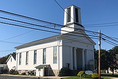
The town features two churches, the First Lutheran Church and the Stewartsville Presbyterian Church.<ref>{{cite web |title=Churches |date=30 January 2014 |url=http://www.greenwichtownship.org/township-at-a-glance-2/churches/ |publisher=Greenwich Township}}</ref> |
|||
<gallery heights="180px" widths="240px" mode="nolines"> |
|||
File:First Lutheran Church, Stewartsville, NJ.jpg|First Lutheran |
|||
File:Stewartsville Presbyterian Church, Stewartsville, NJ.jpg|Stewartsville Presbyterian |
|||
</gallery> |
|||
==Notable people== |
|||
{{Category see also|People from Greenwich Township, Warren County, New Jersey}} |
|||
People who were born in, residents of, or otherwise closely associated with Stewartsville include: |
|||
* [[Orange Cassidy]] (born 1984), professional wrestler<ref>[https://www.ewrestlingnews.com/profiles/orange-cassidy Orange Cassidy], eWrestlingNews. Accessed September 1, 2020. "Born: 05/04/1984 in Stewartsville, New Jersey"</ref> |
|||
* [[Justin Gaymon]] (born 1986), former [[400 metre hurdles|400 metre hurdler]]<ref>[https://www.mcall.com/2008/06/30/bittersweet-finish-for-gaymon/ "Bittersweet finish for Gaymon"], ''[[The Morning Call]]'', June 30, 2008. Accessed September 26, 2023. "He's heading back to Stewartsville, N.J., today and still has another year at Georgia."</ref> |
|||
==References== |
==References== |
||
{{reflist |
{{reflist}} |
||
==External links== |
|||
{{Commons category}} |
|||
{{Warren County, New Jersey}} |
{{Warren County, New Jersey}} |
||
{{Authority control}} |
|||
[[Category:Census-designated places in Warren County, New Jersey]] |
[[Category:Census-designated places in Warren County, New Jersey]] |
||
[[Category:Census-designated places in New Jersey]] |
|||
[[Category:Greenwich Township, Warren County, New Jersey]] |
[[Category:Greenwich Township, Warren County, New Jersey]] |
||
Latest revision as of 22:04, 26 September 2023
Stewartsville, New Jersey | |
|---|---|
 Hulshizer/Brill farm on North main street built in 1833 | |
 Stewartsville Location in Warren County  Stewartsville Location in New Jersey  Stewartsville Location in the United States | |
| Coordinates: 40°41′38″N 75°6′41″W / 40.69389°N 75.11139°W[1][2] | |
| Land | |
| State | |
| County | Warren |
| Township | Greenwich |
| Named for | Thomas Stewart |
| Area | |
| • Total | 1.08 sq mi (2.80 km2) |
| • Land | 1.08 sq mi (2.80 km2) |
| • Water | 0.00 sq mi (0.00 km2) 0.00% |
| Elevation | 315 ft (96 m) |
| Population | |
| • Total | 636 |
| • Density | 587.80/sq mi (226.98/km2) |
| Time zone | UTC−05:00 (Eastern (EST)) |
| • Summer (DST) | UTC−04:00 (EDT) |
| ZIP Code | 08886[5] |
| Area code | 908 |
| FIPS code | 34-70800[6][7][8] |
| GNIS feature ID | 2584031[1] |
Stewartsville is an unincorporated community and census-designated place (CDP) located within Greenwich Township in Warren County, in the U.S. state of New Jersey,[9] that was created as part of the 2010 United States Census.[10][11][12] As of the 2010 Census, the CDP's population was 349.[13]
The area is served as United States Postal Service ZIP Code 08886.[5]
The community of Stewartsville was named after Thomas Stewart, a secretary to George Washington, who purchased property in the area in 1793.[14]
Geography
[edit]According to the United States Census Bureau, the CDP had a total area of 0.129 square miles (0.333 km2), all of which was land.[6][2]
Demographics
[edit]| Census | Pop. | Note | %± |
|---|---|---|---|
| 2020 | 636 | — | |
| U.S. Decennial Census[15][4] | |||
Census 2010
[edit]The 2010 United States census counted 349 people, 134 households, and 96 families in the CDP. The population density was 2,714.4 per square mile (1,048.0/km2). There were 144 housing units at an average density of 1,120.0 per square mile (432.4/km2). The racial makeup was 93.98% (328) White, 4.58% (16) Black or African American, 0.00% (0) Native American, 0.57% (2) Asian, 0.00% (0) Pacific Islander, 0.00% (0) from other races, and 0.86% (3) from two or more races. Hispanic or Latino of any race were 6.30% (22) of the population.[13]
Of the 134 households, 36.6% had children under the age of 18; 52.2% were married couples living together; 14.2% had a female householder with no husband present and 28.4% were non-families. Of all households, 21.6% were made up of individuals and 8.2% had someone living alone who was 65 years of age or older. The average household size was 2.60 and the average family size was 3.05.[13]
26.4% of the population were under the age of 18, 7.4% from 18 to 24, 26.4% from 25 to 44, 27.8% from 45 to 64, and 12.0% who were 65 years of age or older. The median age was 40.3 years. For every 100 females, the population had 97.2 males. For every 100 females ages 18 and older there were 90.4 males.[13]
Census 2000
[edit]As of the 2000 United States Census, the population for ZIP Code Tabulation Area 08886 was 4,854.[16]
Transport
[edit]The area is accessible via exit 4 and exit 3 on Interstate 78.
Stewartsville had a station on the Morris and Essex Railroad, located 80 miles (130 km) from New York City.[17]
Points of interest
[edit]The nearby Kennedy House and Mill, located on Route 173 in Kennedy Mills, was listed on the National Register of Historic Places in 1996.[18]
The town features two churches, the First Lutheran Church and the Stewartsville Presbyterian Church.[19]
-
 First Lutheran
 -
 Stewartsville Presbyterian


Notable people
[edit]People who were born in, residents of, or otherwise closely associated with Stewartsville include:
- Orange Cassidy (born 1984), professional wrestler[20]
- Justin Gaymon (born 1986), former 400 metre hurdler[21]
References
[edit]- ^ a b c "Stewartsville Census Designated Place". Geographic Names Information System. United States Geological Survey, United States Department of the Interior.
- ^ a b US Gazetteer files: 2010, 2000, and 1990, United States Census Bureau. Accessed September 4, 2014.
- ^ "ArcGIS REST Services Directory". United States Census Bureau. Retrieved October 11, 2022.
- ^ a b "Census Population API". United States Census Bureau. Retrieved October 11, 2022.
- ^ a b Look Up a ZIP Code for Stewartsville, NJ, United States Postal Service. Accessed June 3, 2013.
- ^ a b Gazetteer of New Jersey Places, United States Census Bureau. Accessed July 21, 2016.
- ^ U.S. Census website, United States Census Bureau. Accessed September 4, 2014.
- ^ Geographic codes for New Jersey, Missouri Census Data Center. Accessed June 9, 2023.
- ^ Locality Search, State of New Jersey. Accessed April 19, 2015.
- ^ GCT-PH1 - Population, Housing Units, Area, and Density: 2010 - County -- County Subdivision and Place from the 2010 Census Summary File 1 for Warren County, New Jersey Archived 2020-02-12 at archive.today, United States Census Bureau. Accessed June 4, 2013.
- ^ 2006-2010 American Community Survey Geography for New Jersey, United States Census Bureau. Accessed June 4, 2013.
- ^ New Jersey: 2010 - Population and Housing Unit Counts - 2010 Census of Population and Housing (CPH-2-32), United States Census Bureau, p. III-5, August 2012. Accessed June 4, 2013. "Warren County—Name Changes: Beattystown CDP name corrected from Beatyestown; New CDPs: Allamuchy (formed from part of deleted Allamuchy-Panther Valley CDP), Anderson, Asbury, Blairstown, Brainards, Bridgeville, Broadway, Brookfield, Buttzville, Columbia, Delaware, Delaware Park, Finesville, Great Meadows (formed from part of deleted Great Meadows-Vienna CDP and additional area), Greenwich, Hainesburg, Harmony, Hope, Hutchinson, Johnsonburg, Lopatcong Overlook, Marksboro, Mountain Lake, Mount Hermon, New Village, Panther Valley (formed from part of deleted Allamuchy-Panther Valley CDP), Port Colden, Port Murray, Silver Lake, Stewartsville, Upper Pohatcong, Upper Stewartsville, and Vienna (formed from part of deleted Great Meadows-Vienna and additional area)"
- ^ a b c d DP-1 - Profile of General Population and Housing Characteristics: 2010 Demographic Profile Data for Stewartsville CDP, New Jersey, United States Census Bureau. Accessed June 3, 2013.
- ^ Home Page, Greenwich Township. Accessed February 25, 2013. "Our town was named after Thomas Stewart, a secretary to George Washington. Thomas Stewart purchased 360 acres and began to reside in Greenwich in 1793. The original Stewart home still stands along with many other farm houses and mills."
- ^ "Census of Population and Housing". Census.gov. Retrieved June 4, 2016.
- ^ DP-1 Profile of General Demographic Characteristics: 2000 from the Census 2000 Summary File 1 (SF 1) 100-Percent Data for ZCTA 08886 Archived 2020-02-12 at archive.today, United States Census Bureau. Accessed June 3, 2013.
- ^ Travelers' official Guide of the Railways; June 1, 1870: National Railway Publication Company.
- ^ "National Register Information System – (#96000552)". National Register of Historic Places. National Park Service. November 2, 2013.
- ^ "Churches". Greenwich Township. January 30, 2014.
- ^ Orange Cassidy, eWrestlingNews. Accessed September 1, 2020. "Born: 05/04/1984 in Stewartsville, New Jersey"
- ^ "Bittersweet finish for Gaymon", The Morning Call, June 30, 2008. Accessed September 26, 2023. "He's heading back to Stewartsville, N.J., today and still has another year at Georgia."
External links
[edit]Municipalities and communities of Warren County, New Jersey, United States | ||
|---|---|---|
| Boroughs |  | |
| Towns | ||
| Townships | ||
| CDPs |
| |
| Other unincorporated communities | ||
| International | |
|---|---|
| National | |