
Kozhikode Beach: Difference between revisions
m Kites from Kozhikode beach |
move tag down |
||
| (36 intermediate revisions by 22 users not shown) | |||
| Line 1: | Line 1: | ||
{{Use dmy dates|date=March 2016}} |
{{Use dmy dates|date=March 2016}} |
||
{{Use Indian English|date=March 2016}} |
{{Use Indian English|date=March 2016}} |
||
{{ |
{{more citations needed|date=March 2016}} |
||
{{Cleanup bare URLs|date=September 2022}} |
|||
{{Infobox settlement |
{{Infobox settlement |
||
| name = Kozhikode Beach |
| name = Kozhikode Beach |
||
| Line 36: | Line 37: | ||
[[File:Kannam Parambu Masjidh, Kozhikode.jpg|thumbnail|Kannam Parambu Mosque, South Beach]] |
[[File:Kannam Parambu Masjidh, Kozhikode.jpg|thumbnail|Kannam Parambu Mosque, South Beach]] |
||
'''Kozhikode Beach''' is a [[beach]] on the western side of [[Kozhikode]], situated on the [[Malabar Coast]] of [[India]]. The beach is accessible through four road overbridges in the city. The beach has paved stones and illumination. There is one Lions Park for the children and an |
'''Kozhikode Beach''' or '''Calicut Beach''' is a [[beach]] on the western side of [[Kozhikode]], situated on the [[Malabar Coast]] of [[India]]. The beach is accessible through four road overbridges in the city. The beach has paved stones and illumination. There is one Lions Park for the children and an aquarium. Kozhikode beach has always been a prominent place for conducting public meetings. The beach road was renamed 'Gandhi Road' in 1934 after [[Gandhi]] visited Calicut in 1934. |
||
[[File:Beach_palace.jpg|thumb|{{lang-en|kozhikode beach}}]] |
|||
==History== |
==History== |
||
100 years ago Valiyangadi and the beach area were the centre of Kozhikode city. In the 1970s the downtown shifted to [[Mananchira]] area and again, in the 1980s, [[Mavoor Road]] became the centre of attraction. In 2010s, [[Thondayad Junction|Thondayad]] Bypass area and [[Palazhi]] on the [[Calicut Airport|Airport]] road has emerged as the new city centre with a vibrant night life |
100 years ago Valiyangadi and the beach area were the centre of Kozhikode city. In the 1970s the downtown shifted to [[Mananchira]] area and again, in the 1980s, [[Mavoor Road]] became the centre of attraction. In 2010s, [[Thondayad Junction|Thondayad]] Bypass area and [[Palazhi]] on the [[Calicut Airport|Airport]] road has emerged as the new city centre with a vibrant night life. |
||
==Important landmarks== |
==Important landmarks== |
||
| Line 53: | Line 54: | ||
* St.Josephs Boys School |
* St.Josephs Boys School |
||
* District Court, Kozhikode |
* District Court, Kozhikode |
||
*St.Josephs AIGHSS, Convent Road |
|||
*Sea Queen Hotel |
|||
*Beach Hotel |
|||
*Sree Thiruvani Bhagavathi Temple, Moonalingal |
|||
*Government General Hospital, Beach Hospital |
|||
*Hotel Neerayi |
|||
*Merchant Navy Club<ref>{{Cite web|title=Merchant Navy Club, Calicut|url=https://www.google.com/maps/place/Merchant+Navy+Club,+Calicut/@11.2589973,75.7667784,17z/data=!3m1!4b1!4m5!3m4!1s0x3ba6592f0a9f196d:0x3ba4015ecd1e61d5!8m2!3d11.258992!4d75.7689671?shorturl=1|access-date=2021-01-15|website=Merchant Navy Club, Calicut|language=en}}</ref> |
|||
*The Marine Research Aquarium, CMFRI, Beach Road |
|||
*Crescent Mervue Apartments |
|||
*Maha Ganapathi Bhuvaneshwari Temple, Puthiya Kadavu, Beach Road |
|||
*Kamburam Bhagavathy Temple |
|||
*Vellayil Police Station, Beach Road |
|||
*Vellayil Fishing Harbour |
|||
*Appolo Sea Breeze Apartments,Beach Road, |
|||
===The 28-km beach road=== |
===The 28-km beach road=== |
||
| Line 61: | Line 76: | ||
* [[Vellayil]], South Beach and Valiyangadi |
* [[Vellayil]], South Beach and Valiyangadi |
||
* Kamburam, Putiyappa and [[Elathur, Kozhikode|Elathur]] |
* Kamburam, Putiyappa and [[Elathur, Kozhikode|Elathur]] |
||
*Konad, Bhat Road |
|||
===Valiyangadi=== |
===Valiyangadi=== |
||
On the southern side of the beach, Valiyangadi was the place where European and Arab traders brushed shoulders just a few centuries back. There is one Gujarathi Street and a Halwa Street on the locality. |
On the southern side of the beach, Valiyangadi was the place where European and Arab traders brushed shoulders just a few centuries back. There is one Gujarathi Street and a Halwa Street on the locality. The road towards the south reaches the Chakkum Kadavu bridge and has access to the Kallayi, Marad and Beypore beaches. Valiyanagdi have great past and history. We can see the value of valiyangadi in malabar history |
||
===Mishkal Masjidh=== |
===Mishkal Masjidh=== |
||
| Line 71: | Line 87: | ||
===Cherootty Road=== |
===Cherootty Road=== |
||
The Road over bridge from [[Mananchira]] to the Kozhikode beach takes you to the '''Red Cross Road''' that terminates in the beach. Cherootty road is one of the offshoots of the Red Cross Road that ends at Court Road near the [[Mathrubhumi]] newspaper office. This is a major shopping area of the Kozhikode beach area with many branded |
The Road over bridge from [[Mananchira]] to the Kozhikode beach takes you to the '''Red Cross Road''' that terminates in the beach. Cherootty road is one of the offshoots of the Red Cross Road that ends at Court Road near the [[Mathrubhumi]] newspaper office. This is a major shopping area of the Kozhikode beach area with many branded clothing shops and branches of nationalized branches on either side of the road. Gandhi Peace Foundation is maintaining an office there. The convent road is a branch of the Cherootty Road. Tagore Centenary Hall, Muslim League Office, [[Moonnalingal]] junction and the Beach Office are also connected to the Red Cross Road. The Silk Street and the Court Road runs parallel to Cherootty Road. The Silk Street has a Punjabi school, St.Joseph's school and Sidhi Durbar. Further west of the Silk Street lies the beach road which runs north–south from [[Vellayil]] in the north to [[Chakkum Kadavu]] in the south. |
||
===Nalam Gate=== |
===Nalam Gate=== |
||
Nalam Gate or the ''fourth gate'' is a posh shopping locality on ''P.T.Usha Road'' in [[Kozhikode]] city. It is known as a foodie paradise because of the presence of a number of classy restaurants and coffee shops |
Nalam Gate or the ''fourth gate'' is a posh shopping locality on ''P.T.Usha Road'' in [[Kozhikode]] city. It is known as a foodie paradise because of the presence of a number of classy restaurants and coffee shops. |
||
==Image gallery== |
==Image gallery== |
||
<gallery> |
<gallery> |
||
File:Kozhikode beach stall.jpg |
File:Kozhikode beach stall.jpg|Beach stall- [[Shave ice|Shave Ice]] |
||
File:Kozhikode beach kites.jpg |
File:Kozhikode beach kites.jpg|Kite flying |
||
File:Kites Kozhikode.jpg |
File:Kites Kozhikode.jpg|Kites |
||
File:Kozhikode C07986.JPG|Pickled Fruits for sale at Kozhikode Beach |
File:Kozhikode C07986.JPG|Pickled Fruits for sale at Kozhikode Beach |
||
File:Kozhikode Beach 01315.JPG|A view of the Calicut beach |
File:Kozhikode Beach 01315.JPG|A view of the Calicut beach |
||
File:Kozhikode Beach 01302.JPG|Creepers |
|||
File:Kozhikode Beach 01613.JPG|Hindu Flag |
|||
File:Kozhikode Beach 01603.JPG|Beach |
File:Kozhikode Beach 01603.JPG|Beach |
||
</gallery> |
</gallery> |
||
==See also== |
==See also== |
||
* [[Kozhikode]] city |
|||
* [[Kozhikode North]] |
* [[Kozhikode North]] |
||
* [[Kozhikode South]] |
* [[Kozhikode South]] |
||
Latest revision as of 10:54, 14 October 2023
This article needs additional citations for verification. (March 2016) |
Kozhikode Beach | |
|---|---|
 Kozhikode Beach | |
| Coordinates: 11°15′22″N 75°46′10″E / 11.25607°N 75.76940°E | |
| Country | India |
| State | Kerala |


Kozhikode Beach or Calicut Beach is a beach on the western side of Kozhikode, situated on the Malabar Coast of India. The beach is accessible through four road overbridges in the city. The beach has paved stones and illumination. There is one Lions Park for the children and an aquarium. Kozhikode beach has always been a prominent place for conducting public meetings. The beach road was renamed 'Gandhi Road' in 1934 after Gandhi visited Calicut in 1934.

History
[edit]100 years ago Valiyangadi and the beach area were the centre of Kozhikode city. In the 1970s the downtown shifted to Mananchira area and again, in the 1980s, Mavoor Road became the centre of attraction. In 2010s, Thondayad Bypass area and Palazhi on the Airport road has emerged as the new city centre with a vibrant night life.
Important landmarks
[edit]
- Barami Masjidh
- Santhwanam NGO, Cherootty Road
- Gandhi Peace Foundation, Cherootty Road
- All India Radio, Beach Road
- Corporation Office, Beach
- Thodiyil Shree Bhagawathy Temple
- Gurajathi School, Gujarathi Street
- St.Josephs Boys School
- District Court, Kozhikode
- St.Josephs AIGHSS, Convent Road
- Sea Queen Hotel
- Beach Hotel
- Sree Thiruvani Bhagavathi Temple, Moonalingal
- Government General Hospital, Beach Hospital
- Hotel Neerayi
- Merchant Navy Club[1]
- The Marine Research Aquarium, CMFRI, Beach Road
- Crescent Mervue Apartments
- Maha Ganapathi Bhuvaneshwari Temple, Puthiya Kadavu, Beach Road
- Kamburam Bhagavathy Temple
- Vellayil Police Station, Beach Road
- Vellayil Fishing Harbour
- Appolo Sea Breeze Apartments,Beach Road,
The 28-km beach road
[edit]Kozhikode Beach has a long drive from Beypore in the south to Kappad in the north. The following beaches are part of Kozhikode Beach:
- Beypore, Payyanakkal and Marad
- Kallayi, Kuttichira and Thekkeppuram
- Vellayil, South Beach and Valiyangadi
- Kamburam, Putiyappa and Elathur
- Konad, Bhat Road
Valiyangadi
[edit]On the southern side of the beach, Valiyangadi was the place where European and Arab traders brushed shoulders just a few centuries back. There is one Gujarathi Street and a Halwa Street on the locality. The road towards the south reaches the Chakkum Kadavu bridge and has access to the Kallayi, Marad and Beypore beaches. Valiyanagdi have great past and history. We can see the value of valiyangadi in malabar history
Mishkal Masjidh
[edit]The Mishkal Masjidh is a four storied mosque at Kuttichira in Kozhikode city. The mosque is about 700 years old. Originally built of wood in five stories, the mosque was later rebuilt into the present four stories. The mosque has 47 doors, 24 pillars decorated with carvings and a very big prayer hall that can accommodate 400 people. [2]
Cherootty Road
[edit]The Road over bridge from Mananchira to the Kozhikode beach takes you to the Red Cross Road that terminates in the beach. Cherootty road is one of the offshoots of the Red Cross Road that ends at Court Road near the Mathrubhumi newspaper office. This is a major shopping area of the Kozhikode beach area with many branded clothing shops and branches of nationalized branches on either side of the road. Gandhi Peace Foundation is maintaining an office there. The convent road is a branch of the Cherootty Road. Tagore Centenary Hall, Muslim League Office, Moonnalingal junction and the Beach Office are also connected to the Red Cross Road. The Silk Street and the Court Road runs parallel to Cherootty Road. The Silk Street has a Punjabi school, St.Joseph's school and Sidhi Durbar. Further west of the Silk Street lies the beach road which runs north–south from Vellayil in the north to Chakkum Kadavu in the south.
Nalam Gate
[edit]Nalam Gate or the fourth gate is a posh shopping locality on P.T.Usha Road in Kozhikode city. It is known as a foodie paradise because of the presence of a number of classy restaurants and coffee shops.
Image gallery
[edit]-
 Beach stall- Shave Ice
 -
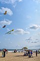 Kite flying
 -
 Kites
Kites -
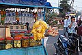 Pickled Fruits for sale at Kozhikode Beach
 -
 A view of the Calicut beach
 -
 Beach
Beach


See also
[edit]References
[edit]- ^ "Merchant Navy Club, Calicut". Merchant Navy Club, Calicut. Retrieved 15 January 2021.
- ^ http://www.keralatourism.org/malabar/mishkal-mosque-kozhikode.php