
Selets: Difference between revisions
m fixed CS1 errors: dates to meet MOS:DATEFORMAT (also General fixes) using AWB (10081) |
No edit summary |
||
| (32 intermediate revisions by 21 users not shown) | |||
| Line 1: | Line 1: | ||
{{Other places3|Sielec (disambiguation){{!}}Sielec}} |
{{Other places3|Sielec (disambiguation){{!}}Sielec}} |
||
{{Infobox settlement |
{{Infobox settlement |
||
|official_name = |
| official_name = Selets |
||
|other_name = |
| other_name = Sielec |
||
|native_name = |
| native_name = Селець |
||
|native_name_lang = ukr |
| native_name_lang = ukr |
||
|settlement_type = Village |
| settlement_type = Village |
||
|image_flag = |
| image_flag = |
||
|nickname = |
| nickname = |
||
|image_skyline = Sielec 008b.JPG |
| image_skyline = Sielec 008b.JPG |
||
|imagesize = 200px |
| imagesize = 200px |
||
|image_caption = Church of the Theotokos and cemetery in |
| image_caption = Church of the [[Synaxis]] of the Theotokos and cemetery in Selets |
||
|image_shield = |
| image_shield = |
||
|image_map = |
| image_map = |
||
|mapsize = |
| mapsize = |
||
|map_caption = Location of |
| map_caption = Location of Selets in Lviv Oblast, western Ukraine |
||
|pushpin_map = Ukraine |
| pushpin_map = Ukraine Lviv Oblast#Ukraine |
||
|pushpin_label_position = bottom |
| pushpin_label_position = bottom |
||
| subdivision_type = [[Countries of the world|Country]] |
|||
|coordinates_display = inline,title |
|||
| |
| subdivision_name = {{UKR}} |
||
| |
| subdivision_type1 = [[Oblast]] |
||
| subdivision_name1 = [[Image:Flag of Lviv Oblast.svg|22px]] [[Lviv Oblast]] |
|||
|subdivision_name = {{UKR}} |
|||
| |
| subdivision_type2 = [[Raion]] |
||
| |
| subdivision_name2 = [[File:Drohobych_Raion_Herb.png|22px]] [[Drohobych Raion]] |
||
| |
| elevation_m = 342 |
||
| ⚫ | |||
|subdivision_name2 = [[File:Drohobych Raion Herb.GIF|22px]] [[Drohobych Raion]] |
|||
| |
| leader_name = Volodymyr Kravets |
||
| |
| established_title = Founded |
||
| |
| established_date = around 1430 |
||
| |
| area_total_km2 = 0.021 |
||
| ⚫ | |||
|established_date = around 1430 |
|||
| ⚫ | |||
|area_total_km2 = 0.021 |
|||
| population_total = 164 |
|||
| ⚫ | |||
| ⚫ | |||
| ⚫ | |||
| |
| timezone = EET |
||
| ⚫ | |||
| ⚫ | |||
| |
| timezone_DST = EEST |
||
| |
| utc_offset_DST = +3 |
||
| coordinates = {{coord|49|27|0|N|23|18|0|E|region:UA|display=inline,title}} |
|||
| ⚫ | |||
| ⚫ | |||
|utc_offset_DST = +3 |
|||
| ⚫ | |||
|latd=49 |latm=27 |lats=0 |latNS=N |
|||
| area_code = [[+380]] 3244 |
|||
|longd=23 |longm=18 |longs=0 |longEW=E |
|||
| ⚫ | |||
| ⚫ | |||
| |
| footnotes = |
||
| ⚫ | |||
| ⚫ | |||
| ⚫ | |||
}} |
}} |
||
[[File:Sielec 009-Sielec 011.jpg|thumb|View of the landscape around |
[[File:Sielec 009-Sielec 011.jpg|thumb|View of the landscape around Selets (2009)]] |
||
[[File:Sielec 007.JPG|thumb|Church |
[[File:Sielec 007.JPG|thumb|Church with belfry, dating to at least the 17th century (2009)]] |
||
[[File:Sielec 012013.JPG|thumb|Interior of the Church |
[[File:Sielec 012013.JPG|thumb|Interior of the Church (2009)]] |
||
'''Selets''' ({{lang-uk|Селець|Selets}}, {{lang-pl|Sielec}}) is a village about 13.5 kilometers southeast of [[Sambir]] within [[Drohobych Raion]] of [[Lviv Oblast]] in western [[Ukraine]]. It belongs to [[Drohobych urban hromada]], one of the [[hromada]]s of Ukraine.<ref name="admreform_2020_drohobych">{{cite web |title=Дрогобычская городская громада |url=https://gromada.info/ru/obschina/drogobych/ |publisher=Портал об'єднаних громад України |language=ru}}</ref> The village was founded probably in the 15th century CE. |
|||
| ⚫ | To the north lies the village and forest of [[Side, Ukraine|Side]] ([[w:uk:Сіде|Сіде]]), to the east [[Horodyshche, Stryi Raion, Lviv Oblast|Horodyshche]] ([[w:uk:Городище|Городище]]), to the south [[Mokriany]] ([[w:uk:Мокряни|Мокряни]]) and to the west [[Vilshanyk]] ([[w:uk:Вільшаник|Вільшаник]]). Geographically, the area lies in the [[Dniester]] river basin, to which the [[Bystrytsia (river)|Bystrytsia]] ([[w:uk:Бистриця|Бистриця]]) and the [[Cherkhavka]] ([[w:uk:Черхавка|Черхавка]]) rivers are tributaries. |
||
'''Sielec''' ({{lang-uk|Сілець}}) is a village about 13.5 kilometers southeast of [[Sambir]] within [[Drohobych Raion|Drohobych district]] of [[Lviv Oblast|Lviv province]] in western [[Ukraine]]. The village was founded probably in the 15th century CE. |
|||
| ⚫ | To the north lies the village and forest of [[Side]] ([[w:uk:Сіде|Сіде]]), to the east [[Horodyshche]] ([[w:uk:Городище|Городище]]), to the south [[Mokriany]] ([[w:uk:Мокряни|Мокряни]]) and to the west [[Vilshanyk]] ([[w:uk:Вільшаник|Вільшаник]]). Geographically, the area lies in the [[Dniester]] river basin, to which the [[Bystrytsia |
||
Together with the villages of [[Kotovane]] ([[w:uk:Котоване|Котоване]]) and [[Stupnytsia]] ([[w:uk:Ступниця|Ступниця]]), it administratively forms a local village council. |
Together with the villages of [[Kotovane]] ([[w:uk:Котоване|Котоване]]) and [[Stupnytsia]] ([[w:uk:Ступниця|Ступниця]]), it administratively forms a local village council. |
||
| Line 60: | Line 56: | ||
The village was first mentioned in 1538 in a document from 1559.<ref>''"A.D. 1538 donat Magnificus Petrus Odrowaz Weryzy et illius successoribus, curiam alias dworyszcze "Waczewo" in villa Sielcze, cum pratis, agris, silvis, mericis, robetis, mellificiis, earumque decursibus, ad dictam aream Waczewo spectantibus, tum etiam Gurdium, alias Potok Uruszny nuncupatam, inter prata ejusdem areae decurrens cum ambabus ryppis. Quam donationem Sigismundus Augustus rex approbat A.D. 1559."'' Rkp. [[Ossolineum]], Nr. 2837, str. 81.</ref> King [[Michał Korybut Wiśniowiecki]] established the parish between 1669 and 1673, during which time a royal church was constructed. Another church with its own parish for the local Polish-speaking nobility (''szlachta'') was built later; both parishes coexisted before they later merged. |
The village was first mentioned in 1538 in a document from 1559.<ref>''"A.D. 1538 donat Magnificus Petrus Odrowaz Weryzy et illius successoribus, curiam alias dworyszcze "Waczewo" in villa Sielcze, cum pratis, agris, silvis, mericis, robetis, mellificiis, earumque decursibus, ad dictam aream Waczewo spectantibus, tum etiam Gurdium, alias Potok Uruszny nuncupatam, inter prata ejusdem areae decurrens cum ambabus ryppis. Quam donationem Sigismundus Augustus rex approbat A.D. 1559."'' Rkp. [[Ossolineum]], Nr. 2837, str. 81.</ref> King [[Michał Korybut Wiśniowiecki]] established the parish between 1669 and 1673, during which time a royal church was constructed. Another church with its own parish for the local Polish-speaking nobility (''szlachta'') was built later; both parishes coexisted before they later merged. |
||
While the area was crown property, the Dżurdż family was given half of it at an unknown date. Around 1650 King [[John II Casimir Vasa|John II Casimir]] awarded the [[Cossack]] [[ |
While the area was crown property, the Dżurdż family was given half of it at an unknown date. Around 1650 King [[John II Casimir Vasa|John II Casimir]] awarded the [[Cossack]] [[Otaman]] Skrebeciowicz the other half of the Sielec estate, as well as the right to bear the [[Sas coat of arms]] for his loyal services to the crown during the [[Khmelnytsky Uprising]]. After the [[Austrian partition]] of southern Poland in 1772, the Skrebeciowicz de [[Sielecki family]]’s noble status was reaffirmed by the imperial court in [[Vienna]] who gave it the hereditary German title of ''[[Ritter]]''.<ref>[http://www.austria.gv.at/site/5001/default.aspx War Archives] (''Kriegsarchiv'') of the Austrian State Archives.</ref> |
||
According to historical documents, in 1880 |
According to historical documents, in 1880 Selets had a total population of 781 inhabitants, of which 657 were [[Greek Catholics]], thirty-two were [[Roman Catholics]], eighty-five were [[Jew]]ish, and seven were of other faiths.<ref name="Królestwa Polskiego">{{cite encyclopedia | title = Sielec | encyclopedia = Słownik geograficzny Królestwa Polskiego i innych krajów słowiańskich | volume = X | pages = 530–531 | publisher = Druk "Wieku" | year = 1889 }}</ref> According to an 1889 census, 728 of the inhabitants at the time were ethnic "[[Ruthenians]]" (i. e. [[Rusyns]] or [[Ukrainians]]), 50 were [[Polish people|Polish]], and three were [[German language|German-speaking]] (''Galiziendeutsche'').<ref name="Królestwa Polskiego"/> Furthermore, the town incorporated 172 houses in the same census; the [[manor house]] (''dwór'') and local lords’ estates employed around forty-seven people.<ref name="Królestwa Polskiego" /> |
||
The area changed hands multiple times: after the collapse of the Austro-Hungarian empire in 1918, |
The area changed hands multiple times: after the collapse of the Austro-Hungarian empire in 1918, Selets reverted to newly independent [[Second Polish Republic|Poland]] and administratively became a part of Lwów Voivodeship. In late September 1939, following German and Soviet aggression on Poland and [[Molotov–Ribbentrop Pact]], Lwów Voivodeship was divided by the two sides. Selets was occupied by the Soviets and incorporated into [[Ukrainian Soviet Socialist Republic]], only to be overrun again by the invading German [[Wehrmacht]] in the summer of 1941. After the war it was finally incorporated into Ukraine. The population dropped substantially due to [[World War II]] and the [[Joseph Stalin|Stalin]]ist Soviet regime. The local Jewish population was murdered during [[the Holocaust]]; after the war, members of the local nobility as well as wealthier peasants and non-Ukrainians were either executed or deported to Siberia by the communists, where they perished in the [[gulag]]s. Farmers were forced to hand over their land for collectivization. After [[revolutions of 1989|the fall of the Iron Curtain in 1989]] and the collapse of the local [[kolkhoz]], high unemployment forced many, especially young people, to leave for larger towns in flights of [[urbanization]]. The 2001 national census counted 164 inhabitants, and in 2009 the village consisted of around 40 houses, down from 300 in the past. |
||
== Sights == |
== Sights == |
||
The area is marked by rolling hills and agricultural land rich with [[chornozem]]. The local economy consists mainly of farming, along with animal husbandry of cattle and horses. The manor house remains have been lost over time as well as the royal church mentioned in historical annals, while the church for the nobility still exists. |
The area is marked by rolling hills and agricultural land rich with [[chornozem]]. The local economy consists mainly of farming, along with animal husbandry of cattle and horses. The manor house remains have been lost over time as well as the royal church mentioned in historical annals, while the church for the nobility still exists. |
||
The Greek Catholic Church of the [[Theotokos]] ({{lang-uk|Богородицька Церква}}) is located on a hill. With its [[Bell tower|belfry]], it serves as an example of a rural [[wooden churches in Ukraine|wooden church in Ukraine]]. Constructed in the seventeenth century,<ref>{{cite web |
The Greek Catholic Church of the [[Synaxis]] of the [[Theotokos]] ({{lang-uk|Богородицька Церква}}) is located on a hill. With its [[Bell tower|belfry]], it serves as an example of a rural [[wooden churches in Ukraine|wooden church in Ukraine]]. Constructed in the seventeenth century,<ref>{{cite web | title = Image of plaque at the church showing building information| work = [[Wikimedia Commons]]| language = uk | date = May 30, 2009 | url = http://commons.wikimedia.org/wiki/File:Sielec_015.JPG | access-date = 2009-07-04}}</ref> it is surrounded by a historic cemetery. The church was funded by local nobility and used for worship by them—members would be buried there as well. It was closed and lay in a ruined state during the Communist era. Only after the end of the Soviet Union was the church restored, using local funds and donations. |
||
The church has a cross-shaped layout consisting of three parts: the [[narthex]] in the front, the central [[nave]] and the [[apse]] in the back, which is shielded by an [[iconostasis]]. The church is around eighteen meters long and eight meters wide; the nave measures less than six meters square. The exterior has a slightly different appearance than in the 1970s, when the towering roofs had to be replaced and made more simply than before.<ref name="Viktor Gromyko">{{cite web | last = Gromyko | first = Viktor | title = СОБОРУ ПР. БОГОРОДИЦІ 1700., с.Селець, Дрогобицький р-н | work = Wooden churches of Lviv | language = |
The church has a cross-shaped layout consisting of three parts: the [[narthex]] in the front, the central [[nave]] and the [[apse]] in the back, which is shielded by an [[iconostasis]]. The church is around eighteen meters long and eight meters wide; the nave measures less than six meters square. The exterior has a slightly different appearance than in the 1970s, when the towering roofs had to be replaced and made more simply than before.<ref name="Viktor Gromyko">{{cite web | last = Gromyko | first = Viktor | script-title = uk:СОБОРУ ПР. БОГОРОДИЦІ 1700., с.Селець, Дрогобицький р-н | work = Wooden churches of Lviv | language = uk | date = 2007–2008 | url = http://der-cer.lviv.ua/selets.html | access-date = 2009-07-04 | url-status = dead | archive-url = https://web.archive.org/web/20080405181527/http://der-cer.lviv.ua/selets.html | archive-date = 2008-04-05 }}</ref> The nave is capped by a small octagonal dome that is richly decorated with religious paintings and painted in white and light blue. The floor is carpeted. The iconostasis probably dates to the nineteenth century.<ref name="Viktor Gromyko" /> The nobility had reserved benches on the left side of the church, while the Ruthenian peasants would sit or stand to the right. The church is listed as a protected heritage site. |
||
The smaller Chapel of the Holy Apostles [[Saint Peter|Peter]] and [[Saint Paul|Paul]] is located close to the foot of the hill. Built of concrete, it is a smaller edifice constructed in 2000 to commemorate the second millennium and was dedicated on July 12, 2000.<ref>{{cite web |
The smaller Chapel of the Holy Apostles [[Saint Peter|Peter]] and [[Saint Paul|Paul]] is located close to the foot of the hill. Built of concrete, it is a smaller edifice constructed in 2000 to commemorate the second millennium and was dedicated on July 12, 2000.<ref>{{cite web | title = Image of plaque at the chapel showing building information| work = Wikimedia Commons| language = uk | date = May 30, 2009 | url = http://commons.wikimedia.org/wiki/File:Sielec_016.JPG | access-date = 2009-07-04}}</ref> It replaced a previous wooden chapel that was originally used only by the local peasants. Located along the road leading to the village is the new cemetery. From Selets en route to Drohobych lies a memorial site in a forest for the local Jewish population that was murdered during the Shoah. |
||
== Gallery == |
== Gallery == |
||
<gallery> |
<gallery> |
||
File:Church of the Theotokos.svg|Layout of the Church of the Theotokos |
File:Church of the Theotokos.svg|Layout of the Church of the Synaxis of the Theotokos |
||
File:Sielec 001.JPG|One of the oldest tombs in the old cemetery of the Sielecki family |
File:Sielec 001.JPG|One of the oldest tombs in the old cemetery of the Sielecki family |
||
File:Sielec P1040362.JPG|Grave at the old cemetery of Olga |
File:Sielec P1040362.JPG|Grave at the old cemetery of Olga Sielecka (1908-1931) |
||
File:Sielec 018.JPG|Chapel of the Holy Apostles Peter and Paul |
File:Sielec 018.JPG|Chapel of the Holy Apostles Peter and Paul |
||
File:Sielec 21.JPG|Local school and community house |
File:Sielec 21.JPG|Local school and community house |
||
File:Sielec 20.JPG|Local store ''ПРОДУКТИ'' |
File:Sielec 20.JPG|Local store ''ПРОДУКТИ'' |
||
File:Sielec 019.JPG|Crucifix set up in 2002 opposite the new cemetery |
File:Sielec 019.JPG|Crucifix set up in 2002 opposite the new cemetery |
||
File:Sielec P1040354.JPG| |
File:Sielec P1040354.JPG|Road sign off the main road between Sambir and Drohobych |
||
</gallery> |
</gallery> |
||
| Line 91: | Line 87: | ||
== Literature == |
== Literature == |
||
* Krushynska, Olena (2007). ''[http://www.derev.org.ua/main/44_e.htm Forty four wooden churches of Lviv region]''. Grani-T, Kiev. pp. 62–64. ISBN |
* Krushynska, Olena (2007). ''[http://www.derev.org.ua/main/44_e.htm Forty four wooden churches of Lviv region]''. Grani-T, Kiev. pp. 62–64. {{ISBN|978-966-465-076-9}}. (in Ukrainian). |
||
* Slobodyan, V. (1998). ''Churches of Ukraine: Perzemyhsl diocese''. Lviv. pp. 863. (in Ukrainian). |
* Slobodyan, V. (1998). ''Churches of Ukraine: Perzemyhsl diocese''. Lviv. pp. 863. (in Ukrainian). |
||
== External links == |
== External links == |
||
{{ |
{{commons category-inline|Sielec, Drohobych Raion}} |
||
* {{Citation |
* {{Citation | contribution = Sielec | title = [[Geographical Dictionary of the Kingdom of Poland]] | volume = X | pages = 530–531 | publisher = Druk "Wieku" | place = Warsaw | year = 1889 | language = pl| contribution-url = http://dir.icm.edu.pl/pl/Slownik_geograficzny/Tom_X/530}} |
||
[[Category: |
[[Category:Holocaust locations in Ukraine]] |
||
[[Category:Villages in Drohobych Raion]] |
|||
Latest revision as of 22:48, 17 November 2023
Selets
Селець Sielec | |
|---|---|
Village | |
 Church of the Synaxis of the Theotokos and cemetery in Selets | |
 Selets Location of Selets in Lviv Oblast, western Ukraine  Selets Selets (Ukraine) | |
| Coordinates: 49°27′0″N 23°18′0″E / 49.45000°N 23.30000°E | |
| Land | |
| Oblast | |
| Raion | |
| Gegründet | around 1430 |
| Regierung | |
| • Mayor | Volodymyr Kravets |
| Area | |
| • Total | 0.021 km2 (0.008 sq mi) |
| Elevation | 342 m (1,122 ft) |
| Population (2001) | |
| • Total | 164 |
| Time zone | UTC+2 (EET) |
| • Summer (DST) | UTC+3 (EEST) |
| Postal code | 82123 |
| Area code | +380 3244 |
| Website | Selets on the Verkhovna Rada of Ukraine website |


Selets (Ukrainian: Селець, romanized: Selets, Polish: Sielec) is a village about 13.5 kilometers southeast of Sambir within Drohobych Raion of Lviv Oblast in western Ukraine. It belongs to Drohobych urban hromada, one of the hromadas of Ukraine.[1] The village was founded probably in the 15th century CE.
To the north lies the village and forest of Side (Сіде), to the east Horodyshche (Городище), to the south Mokriany (Мокряни) and to the west Vilshanyk (Вільшаник). Geographically, the area lies in the Dniester river basin, to which the Bystrytsia (Бистриця) and the Cherkhavka (Черхавка) rivers are tributaries.
Together with the villages of Kotovane (Котоване) and Stupnytsia (Ступниця), it administratively forms a local village council.
History
[edit]The village was first mentioned in 1538 in a document from 1559.[2] King Michał Korybut Wiśniowiecki established the parish between 1669 and 1673, during which time a royal church was constructed. Another church with its own parish for the local Polish-speaking nobility (szlachta) was built later; both parishes coexisted before they later merged.
While the area was crown property, the Dżurdż family was given half of it at an unknown date. Around 1650 King John II Casimir awarded the Cossack Otaman Skrebeciowicz the other half of the Sielec estate, as well as the right to bear the Sas coat of arms for his loyal services to the crown during the Khmelnytsky Uprising. After the Austrian partition of southern Poland in 1772, the Skrebeciowicz de Sielecki family’s noble status was reaffirmed by the imperial court in Vienna who gave it the hereditary German title of Ritter.[3]
According to historical documents, in 1880 Selets had a total population of 781 inhabitants, of which 657 were Greek Catholics, thirty-two were Roman Catholics, eighty-five were Jewish, and seven were of other faiths.[4] According to an 1889 census, 728 of the inhabitants at the time were ethnic "Ruthenians" (i. e. Rusyns or Ukrainians), 50 were Polish, and three were German-speaking (Galiziendeutsche).[4] Furthermore, the town incorporated 172 houses in the same census; the manor house (dwór) and local lords’ estates employed around forty-seven people.[4]
The area changed hands multiple times: after the collapse of the Austro-Hungarian empire in 1918, Selets reverted to newly independent Poland and administratively became a part of Lwów Voivodeship. In late September 1939, following German and Soviet aggression on Poland and Molotov–Ribbentrop Pact, Lwów Voivodeship was divided by the two sides. Selets was occupied by the Soviets and incorporated into Ukrainian Soviet Socialist Republic, only to be overrun again by the invading German Wehrmacht in the summer of 1941. After the war it was finally incorporated into Ukraine. The population dropped substantially due to World War II and the Stalinist Soviet regime. The local Jewish population was murdered during the Holocaust; after the war, members of the local nobility as well as wealthier peasants and non-Ukrainians were either executed or deported to Siberia by the communists, where they perished in the gulags. Farmers were forced to hand over their land for collectivization. After the fall of the Iron Curtain in 1989 and the collapse of the local kolkhoz, high unemployment forced many, especially young people, to leave for larger towns in flights of urbanization. The 2001 national census counted 164 inhabitants, and in 2009 the village consisted of around 40 houses, down from 300 in the past.
Sights
[edit]The area is marked by rolling hills and agricultural land rich with chornozem. The local economy consists mainly of farming, along with animal husbandry of cattle and horses. The manor house remains have been lost over time as well as the royal church mentioned in historical annals, while the church for the nobility still exists.
The Greek Catholic Church of the Synaxis of the Theotokos (Ukrainian: Богородицька Церква) is located on a hill. With its belfry, it serves as an example of a rural wooden church in Ukraine. Constructed in the seventeenth century,[5] it is surrounded by a historic cemetery. The church was funded by local nobility and used for worship by them—members would be buried there as well. It was closed and lay in a ruined state during the Communist era. Only after the end of the Soviet Union was the church restored, using local funds and donations.
The church has a cross-shaped layout consisting of three parts: the narthex in the front, the central nave and the apse in the back, which is shielded by an iconostasis. The church is around eighteen meters long and eight meters wide; the nave measures less than six meters square. The exterior has a slightly different appearance than in the 1970s, when the towering roofs had to be replaced and made more simply than before.[6] The nave is capped by a small octagonal dome that is richly decorated with religious paintings and painted in white and light blue. The floor is carpeted. The iconostasis probably dates to the nineteenth century.[6] The nobility had reserved benches on the left side of the church, while the Ruthenian peasants would sit or stand to the right. The church is listed as a protected heritage site.
The smaller Chapel of the Holy Apostles Peter and Paul is located close to the foot of the hill. Built of concrete, it is a smaller edifice constructed in 2000 to commemorate the second millennium and was dedicated on July 12, 2000.[7] It replaced a previous wooden chapel that was originally used only by the local peasants. Located along the road leading to the village is the new cemetery. From Selets en route to Drohobych lies a memorial site in a forest for the local Jewish population that was murdered during the Shoah.
Gallery
[edit]-
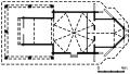 Layout of the Church of the Synaxis of the Theotokos
 -
 One of the oldest tombs in the old cemetery of the Sielecki family
 -
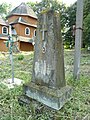 Grave at the old cemetery of Olga Sielecka (1908-1931)
 -
 Chapel of the Holy Apostles Peter and Paul
 -
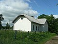 Local school and community house
 -
 Local store ПРОДУКТИ
 -
 Crucifix set up in 2002 opposite the new cemetery
 -
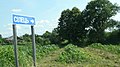 Road sign off the main road between Sambir and Drohobych


References
[edit]- ^ "Дрогобычская городская громада" (in Russian). Портал об'єднаних громад України.
- ^ "A.D. 1538 donat Magnificus Petrus Odrowaz Weryzy et illius successoribus, curiam alias dworyszcze "Waczewo" in villa Sielcze, cum pratis, agris, silvis, mericis, robetis, mellificiis, earumque decursibus, ad dictam aream Waczewo spectantibus, tum etiam Gurdium, alias Potok Uruszny nuncupatam, inter prata ejusdem areae decurrens cum ambabus ryppis. Quam donationem Sigismundus Augustus rex approbat A.D. 1559." Rkp. Ossolineum, Nr. 2837, str. 81.
- ^ War Archives (Kriegsarchiv) of the Austrian State Archives.
- ^ a b c "Sielec". Słownik geograficzny Królestwa Polskiego i innych krajów słowiańskich. Vol. X. Druk "Wieku". 1889. pp. 530–531.
- ^ "Image of plaque at the church showing building information". Wikimedia Commons (in Ukrainian). May 30, 2009. Retrieved 2009-07-04.
- ^ a b Gromyko, Viktor (2007–2008). СОБОРУ ПР. БОГОРОДИЦІ 1700., с.Селець, Дрогобицький р-н. Wooden churches of Lviv (in Ukrainian). Archived from the original on 2008-04-05. Retrieved 2009-07-04.
- ^ "Image of plaque at the chapel showing building information". Wikimedia Commons (in Ukrainian). May 30, 2009. Retrieved 2009-07-04.
Literature
[edit]- Krushynska, Olena (2007). Forty four wooden churches of Lviv region. Grani-T, Kiev. pp. 62–64. ISBN 978-966-465-076-9. (in Ukrainian).
- Slobodyan, V. (1998). Churches of Ukraine: Perzemyhsl diocese. Lviv. pp. 863. (in Ukrainian).
External links
[edit]![]() Media related to Sielec, Drohobych Raion at Wikimedia Commons
Media related to Sielec, Drohobych Raion at Wikimedia Commons
- "Sielec", Geographical Dictionary of the Kingdom of Poland (in Polish), vol. X, Warsaw: Druk "Wieku", 1889, pp. 530–531