
White Head Island: Difference between revisions
Cornellier (talk | contribs) m tweak infobox |
update |
||
| (17 intermediate revisions by 12 users not shown) | |||
| Line 1: | Line 1: | ||
{{Short description|Island in New Brunswick, Canada}} |
|||
{{redirect|White head|the village in County Durham, England|White-le-Head|other uses|Whitehead (disambiguation){{!}}Whitehead}} |
{{redirect|White head|the village in County Durham, England|White-le-Head|other uses|Whitehead (disambiguation){{!}}Whitehead}} |
||
{{Use Canadian English|date=January 2023}} |
|||
{{Infobox islands |
{{Infobox islands |
||
| name = White Head Island |
| name = White Head Island |
||
| native_name = |
|||
| native_name_link = |
|||
| native_name_lang = |
|||
| sobriquet = |
|||
| image_name = |
|||
| image_size = |
|||
| image_caption = |
|||
| image_alt = |
|||
| map = Canada New Brunswick |
| map = Canada New Brunswick |
||
| map_alt = |
|||
| map_width = 220 |
| map_width = 220 |
||
| map_caption = Location in the Bay of Fundy |
| map_caption = Location in the Bay of Fundy |
||
| map_relief = |
|||
| label = |
|||
| label_position = top |
| label_position = top |
||
| coordinates = {{coord|44|37|52.6|N|66|42|28.63|W|display=it}} |
| coordinates = {{coord|44|37|52.6|N|66|42|28.63|W|display=it}} |
||
| etymology = |
|||
| location = Bay of Fundy |
| location = Bay of Fundy |
||
| GridReference = <!-- UK only --> |
|||
| archipelago = Grand Manan Archipelago |
| archipelago = Grand Manan Archipelago |
||
| waterbody = |
|||
| total_islands = |
|||
| major_islands = |
|||
| area_km2 = 6.17 |
| area_km2 = 6.17 |
||
| area_footnotes = |
|||
| rank = |
|||
| length_km = <!-- or |length_m= --> |
|||
| length_footnotes = |
|||
| width_km = <!-- or |width_m= --> |
|||
| width_footnotes = |
|||
| coastline_km = <!-- or |coastline_m= --> |
|||
| coastline_footnotes = |
|||
| elevation_m = |
|||
| elevation_footnotes = |
|||
| highest_mount = |
|||
| country = Canada |
| country = Canada |
||
| country_admin_divisions_title = [[Provinces and territories of Canada|Province]] |
| country_admin_divisions_title = [[Provinces and territories of Canada|Province]] |
||
| Line 44: | Line 19: | ||
| country_admin_divisions_title_2 = [[List of parishes in New Brunswick|Parish]] |
| country_admin_divisions_title_2 = [[List of parishes in New Brunswick|Parish]] |
||
| country_admin_divisions_2 = Grand Manan Parish |
| country_admin_divisions_2 = Grand Manan Parish |
||
| country_capital_type = |
|||
| country_capital = |
|||
| country_largest_city_type = |
|||
| country_largest_city = |
|||
| country_capital_and_largest_city = |
|||
| country_largest_city_population = |
|||
| country_leader_title = |
|||
| country_leader_name = |
|||
| country_area_km2 = <!-- or |country_area_m2= or |country_area_ha= --> |
|||
| country_1 = |
|||
| country_1_admin_divisions_title = |
|||
| country_1_admin_divisions = |
|||
| country_1_admin_divisions_title_1 = |
|||
| country_1_admin_divisions_1 = |
|||
| country_1_capital_type = |
|||
| country_1_capital = |
|||
| country_1_largest_city_type = |
|||
| country_1_largest_city = |
|||
| country_1_capital_and_largest_city = |
|||
| country_1_largest_city_population = |
|||
| country_1_leader_title = |
|||
| country_1_leader_name = |
|||
| country_1_area_km2 = <!-- or |country_1_area_m2= or |country_1_area_ha= --> |
|||
| demonym = |
|||
| population = 162 |
| population = 162 |
||
| population_as_of = 2011 |
| population_as_of = 2011 |
||
| population_footnotes = <ref name="2011census" /> |
| population_footnotes = <ref name="2011census" /> |
||
| population_rank = |
|||
| population_rank_max = |
|||
| density_km2 = 26.3 |
| density_km2 = 26.3 |
||
| module = {{Infobox lighthouse | qid = Q33416380 | embed=yes |
|||
| density_rank = |
|||
| density_footnotes = |
|||
| languages = |
|||
| ethnic_groups = |
|||
| timezone1 = |
|||
| utc_offset1 = |
|||
| timezone1_DST = |
|||
| utc_offset1_DST = |
|||
| website = |
|||
| additional_info = |
|||
}} |
|||
{{Infobox lighthouse |
|||
| item = Q33416380 |
|||
| name = Long Point Lighthouse |
|||
| image_name = WhiteHeadIslandNB.jpg |
|||
| image_width = |
|||
| caption = Long Point Lighthouse at the southern tip of White Head Island |
|||
| location = Long Point<br />White Head Island<br />[[New Brunswick]]<br />[[Canada]] |
|||
| pushpin_map = New Brunswick |
|||
| pushpin_map_caption = New Brunswick |
|||
| pushpin = lighthouse |
|||
| coordinates = {{coord|44|36|49.85|N|66|42|35.48|W}} |
|||
| coordinates_footnotes = |
|||
| yearbuilt = 1966 |
|||
| yearlit = |
|||
| automated = |
|||
| yeardeactivated = |
|||
| foundation = concrete base |
| foundation = concrete base |
||
| construction = concrete tower |
| construction = concrete tower |
||
| shape = quadrangular tower with balcony and lantern rising from the fog signal building |
| shape = quadrangular tower with balcony and lantern rising from the fog signal building<ref>{{cite ngall|110|2015|}}</ref> |
||
| marking = white tower, red lantern |
| marking = white tower, red lantern |
||
| height = {{convert|11|m|ft}} |
|||
| focalheight = {{convert|15.5|m|ft}} |
|||
| lens = |
|||
| currentlens = |
|||
| lightsource = solar power |
|||
| intensity = |
|||
| range = {{convert|12|nmi}}<ref>{{cite ngall|110|2015|}}</ref> |
|||
| characteristic = Iso W 12s. |
|||
| fogsignal = 2s. blast every 20s. |
| fogsignal = 2s. blast every 20s. |
||
| managingagent = Canadian Coast Guard<ref>{{Cite rowlett|nb|accessdate=2017-03-23}}</ref><ref>[http://www.lighthousefriends.com/light.asp?ID=1208 Long Point, NB] ''Lighthouse Friends''. Retrieved 23 March 2017</ref> |
|||
| racon = |
|||
}}}} |
|||
| admiralty = H4178 |
|||
| canada = CCG 25 |
|||
| NGA = 11400 |
|||
| ARLHS = CAN-644 |
|||
| USCG = |
|||
| country = |
|||
| countrynumber = |
|||
| countrylink = |
|||
| managingagent = Canadian Coast Guard<ref>[https://www.unc.edu/~rowlett/lighthouse/nb.htm Southern New Brunswick] ''The Lighthouse Directory''. University of North Carolina at Chapel Hill. Retrieved 23 March 2017</ref><ref>[http://www.lighthousefriends.com/light.asp?ID=1208 Long Point, NB] ''Lighthouse Friends''. Retrieved 23 March 2017</ref> |
|||
| heritage = |
|||
| module = |
|||
}} |
|||
'''White Head Island''' is an island located in the [[Bay of Fundy]]. It is off the east coast of [[Grand Manan|Grand Manan Island]], [[New Brunswick]]. In 2011 the island had a population of 162. White Head Island |
'''White Head Island''' is an island located in the [[Bay of Fundy]]. It is off the east coast of [[Grand Manan|Grand Manan Island]], [[New Brunswick]]. In 2011 the island had a population of 162. White Head Island was governed as a [[Local service district (New Brunswick)|local service district]]<ref name="2011census">{{cite web|title=White Head, New Brunswick. Census Profile|url=http://www12.statcan.gc.ca/census-recensement/2011/dp-pd/prof/details/page.cfm?Lang=E&Geo1=DPL&Code1=130102&Geo2=PR&Code2=01&Data=Count&SearchText=white%20head&SearchType=Begins&SearchPR=01&B1=All&Custom=&TABID=1|website=2011 Census|publisher=Statistics Canada|date=2012}}</ref> prior to the [[2023 New Brunswick local governance reform]]. |
||
Its economy is based largely around [[aquaculture]] and fishing.<ref>{{Cite web|url=http://ambleinncottages.com/todo.html|title=...things to do while on Grand Manan|date=September 2018|website=ambleinncottages.com/}}</ref> |
Its economy is based largely around [[aquaculture]] and fishing.<ref>{{Cite web|url=http://ambleinncottages.com/todo.html|title=...things to do while on Grand Manan|date=September 2018|website=ambleinncottages.com/|access-date=2018-10-17|archive-date=2018-10-17|archive-url=https://web.archive.org/web/20181017082212/http://ambleinncottages.com/todo.html|url-status=dead}}</ref> |
||
The island has an elementary school which has kindergarten to grade 2 and grades 3 to 6 in two separate classrooms. Recently there have been efforts to move children to the larger [[Grand Manan Community School]] however the younger grades remain on White Head due to the ferry crossing. It's the smallest school within the [[Anglophone South School District]] of Southern New Brunswick. |
The island has an elementary school which has kindergarten to grade 2 and grades 3 to 6 in two separate classrooms. Recently there have been efforts to move children to the larger [[Grand Manan Community School]] however the younger grades remain on White Head due to the ferry crossing. It's the smallest school within the [[Anglophone South School District]] of Southern New Brunswick. |
||
[[Coastal Transport Limited]] provides [[Roll-on/roll-off|car ferry]] service between White Head and Grand Manan. The ferry ''William Frankland'' operates year-round and is free of charge.<ref name="ferryschedule">{{cite web|title=White Head Schedule|url=http://whitehead.coastaltransport.ca/schedule.html|website=Coastal Transport| |
[[Coastal Transport Limited]] provides [[Roll-on/roll-off|car ferry]] service between White Head and Grand Manan. The ferry ''William Frankland'' operates year-round and is free of charge.<ref name="ferryschedule">{{cite web|title=White Head Schedule|url=http://whitehead.coastaltransport.ca/schedule.html|website=Coastal Transport|access-date=3 July 2017}}</ref> |
||
Until 2022 the community had a small general store located at the dock where the ferry arrives at the island. |
|||
There is a Baptist church on the island that was completed in 1981. However, there are records of a religious house in use until 1928, when the second of three churches was dedicated.<ref>{{cite web|title=White Head Baptist Church|url=http://www.rootsweb.ancestry.com/~nbgrandm/Church/whiteheadbaptistchurch.htm|website=Ancestry.com| |
There is a Baptist church on the island that was completed in 1981. However, there are records of a religious house in use until 1928, when the second of three churches was dedicated.<ref>{{cite web|title=White Head Baptist Church|url=http://www.rootsweb.ancestry.com/~nbgrandm/Church/whiteheadbaptistchurch.htm|website=Ancestry.com|access-date=2017-05-01}}</ref> |
||
==Gallery== |
==Gallery== |
||
| Line 159: | Line 62: | ||
{{New Brunswick Islands}} |
{{New Brunswick Islands}} |
||
{{Lighthouses of Canada}} |
{{Lighthouses of Canada}} |
||
{{Authority control | additional=Q33416380}} |
|||
[[Category:Coastal islands of New Brunswick]] |
[[Category:Coastal islands of New Brunswick]] |
||
Latest revision as of 15:43, 31 December 2023
 White Head Island Location in the Bay of Fundy | |
| Geography | |
|---|---|
| Standort | Bay of Fundy |
| Coordinates | 44°37′52.6″N 66°42′28.63″W / 44.631278°N 66.7079528°W |
| Archipelago | Grand Manan Archipelago |
| Area | 6.17 km2 (2.38 sq mi) |
| Administration | |
Kanada | |
| Province | New Brunswick |
| County | Charlotte |
| Parish | Grand Manan Parish |
| Demographics | |
| Population | 162 (2011)[1] |
| Pop. density | 26.3/km2 (68.1/sq mi) |
| Long Point Lighthouse | |
 Long Point Lighthouse at the southern tip of White Head Island | |
| Constructed | 1966 |
| Foundation | concrete base |
| Bauwesen | concrete tower |
| Height | 11 m (36 ft) |
| Shape | quadrangular tower with balcony and lantern rising from the fog signal building[2] |
| Markings | white tower, red lantern |
| Power source | solar power |
| Operator | Canadian Coast Guard[3][4] |
| Fog signal | 2s. blast every 20s. |
| Focal height | 15.5 m (51 ft) |
| Range | 12 nmi (22 km; 14 mi) |
| Characteristic | Iso W 12s |
White Head Island is an island located in the Bay of Fundy. It is off the east coast of Grand Manan Island, New Brunswick. In 2011 the island had a population of 162. White Head Island was governed as a local service district[1] prior to the 2023 New Brunswick local governance reform.
Its economy is based largely around aquaculture and fishing.[5]
The island has an elementary school which has kindergarten to grade 2 and grades 3 to 6 in two separate classrooms. Recently there have been efforts to move children to the larger Grand Manan Community School however the younger grades remain on White Head due to the ferry crossing. It's the smallest school within the Anglophone South School District of Southern New Brunswick.
Coastal Transport Limited provides car ferry service between White Head and Grand Manan. The ferry William Frankland operates year-round and is free of charge.[6]
Until 2022 the community had a small general store located at the dock where the ferry arrives at the island.
There is a Baptist church on the island that was completed in 1981. However, there are records of a religious house in use until 1928, when the second of three churches was dedicated.[7]
Gallery
[edit]-
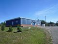 White Head elementary school August, 2016
 -
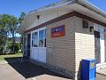 White Head Post Office
 -
 The car ferry William Frankland at Ingalls Head


See also
[edit]- List of lighthouses in New Brunswick
- List of communities in New Brunswick
- List of islands of New Brunswick
References
[edit]- ^ a b "White Head, New Brunswick. Census Profile". 2011 Census. Statistics Canada. 2012.
- ^ List of Lights, Pub. 110: Greenland, The East Coasts of North and South America (Excluding Continental U.S.A. Except the East Coast of Florida) and the West Indies (PDF). List of Lights. United States National Geospatial-Intelligence Agency. 2015.
- ^ Rowlett, Russ. "Lighthouses of Canada: Southern New Brunswick". The Lighthouse Directory. University of North Carolina at Chapel Hill. Retrieved 2017-03-23.
- ^ Long Point, NB Lighthouse Friends. Retrieved 23 March 2017
- ^ "...things to do while on Grand Manan". ambleinncottages.com/. September 2018. Archived from the original on 2018-10-17. Retrieved 2018-10-17.
- ^ "White Head Schedule". Coastal Transport. Retrieved 3 July 2017.
- ^ "White Head Baptist Church". Ancestry.com. Retrieved 2017-05-01.
This New Brunswick location article is a stub. You can help Wikipedia by expanding it. |