Saudemont: Difference between revisions
Appearance
Content deleted Content added
m mayor |
mNo edit summary |
||
| (5 intermediate revisions by 3 users not shown) | |||
| Line 1: | Line 1: | ||
{{Use dmy dates|date=August 2023}} |
|||
{{Infobox French commune |
{{Infobox French commune |
||
|name = Saudemont |
|name = Saudemont |
||
| Line 22: | Line 23: | ||
}} |
}} |
||
'''Saudemont''' is a [[Communes of France|commune]] in the [[Pas-de-Calais]] [[Departments of France|department]] in the [[Hauts-de-France]] region of [[France]]. |
'''Saudemont''' ({{IPA-fr|sodmɔ̃}}) is a [[Communes of France|commune]] in the [[Pas-de-Calais]] [[Departments of France|department]] in the [[Hauts-de-France]] region of [[France]].<ref>[https://www.insee.fr/fr/metadonnees/cog/commune/COM62782-saudemont INSEE commune file]</ref> |
||
==Geography== |
==Geography== |
||
Saudemont lies {{convert |14|mi|km |
Saudemont lies {{convert |14|mi|km}} southeast of Arras, at the junction of the D39 and D13 roads. The [[A26 autoroute]] passes by at a distance of half a mile. |
||
==Population== |
==Population== |
||
| Line 37: | Line 38: | ||
| 2012|452 |
| 2012|452 |
||
| 2017|449 |
| 2017|449 |
||
| source = INSEE<ref>[https://www.insee.fr/fr/statistiques/4515315?geo=COM-62782#POP_T1 Population en historique depuis 1968], INSEE</ref> |
| source = INSEE<ref>[https://www.insee.fr/fr/statistiques/4515315?geo=COM-62782#ancre-POP_T1 Population en historique depuis 1968], INSEE</ref> |
||
| percentages = pagr |
| percentages = pagr |
||
| align = none |
| align = none |
||
| Line 43: | Line 44: | ||
==Places of interest== |
==Places of interest== |
||
* The church of St.Léger, dating from the twelfth century. |
* The church of St. Léger, dating from the twelfth century. |
||
==See also== |
==See also== |
||
[[Communes of the Pas-de-Calais department]] |
*[[Communes of the Pas-de-Calais department]] |
||
==References== |
==References== |
||
* [http://www.insee.fr/fr/methodes/nomenclatures/cog/fichecommunale.asp?codedep=62&codecom=782 INSEE commune file] |
|||
{{Reflist}} |
{{Reflist}} |
||
Latest revision as of 16:15, 7 January 2024
Saudemont | |
|---|---|
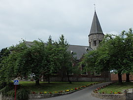
 The church of Saudemont | |
| Coordinates: 50°14′41″N 3°02′27″E / 50.2447°N 3.0408°E | |
| Land | Frankreich |
| Region | Hauts-de-France |
| Department | Pas-de-Calais |
| Arrondissement | Arras |
| Canton | Brebières |
| Intercommunality | CC Osartis Marquion |
| Regierung | |
| • Mayor (2020–2026) | Laurent Turpin[1] |
| Area 1 | 5.55 km2 (2.14 sq mi) |
| Population (2021)[2] | 433 |
| • Density | 78/km2 (200/sq mi) |
| Time zone | UTC+01:00 (CET) |
| • Summer (DST) | UTC+02:00 (CEST) |
| INSEE/Postal code | 62782 /62860 |
| Elevation | 39–75 m (128–246 ft) (avg. 48 m or 157 ft) |
| 1 French Land Register data, which excludes lakes, ponds, glaciers > 1 km2 (0.386 sq mi or 247 acres) and river estuaries. | |
Saudemont (French pronunciation: [sodmɔ̃]) is a commune in the Pas-de-Calais department in the Hauts-de-France region of Frankreich.[3]
Geography
[edit]Saudemont lies 14 miles (23 km) southeast of Arras, at the junction of the D39 and D13 roads. The A26 autoroute passes by at a distance of half a mile.
Population
[edit]| Year | Pop. | ±% p.a. |
|---|---|---|
| 1968 | 315 | — |
| 1975 | 300 | −0.69% |
| 1982 | 374 | +3.20% |
| 1990 | 382 | +0.26% |
| 1999 | 375 | −0.21% |
| 2007 | 432 | +1.78% |
| 2012 | 452 | +0.91% |
| 2017 | 449 | −0.13% |
| Source: INSEE[4] | ||
Places of interest
[edit]- The church of St. Léger, dating from the twelfth century.
See also
[edit]References
[edit]- ^ "Répertoire national des élus: les maires". data.gouv.fr, Plateforme ouverte des données publiques françaises (in French). 9 August 2021.
- ^ "Populations légales 2021" (in French). The National Institute of Statistics and Economic Studies. 28 December 2023.
- ^ INSEE commune file
- ^ Population en historique depuis 1968, INSEE
External links
[edit]Wikimedia Commons has media related to Saudemont.


