Bimanbandar Thana (Dhaka): Difference between revisions
Appearance
Content deleted Content added
No edit summary Tags: Visual edit Mobile edit Mobile web edit Advanced mobile edit |
+ref |
||
| (5 intermediate revisions by 3 users not shown) | |||
| Line 1: | Line 1: | ||
{{Infobox settlement |
|||
| official_name = Bimanbandar Thana |
|||
| native_name = বিমান বন্দর থানা (ঢাকা মেট্রোপলিটন) |
|||
| settlement_type = [[Upazilas of Bangladesh|Thana]] |
|||
| image_skyline = |
|||
| image_alt = |
|||
| image_caption = |
|||
| blank_emblem_link = |
|||
| pushpin_map = Bangladesh Dhaka#Bangladesh Dhaka division#Bangladesh |
|||
| pushpin_map_caption = Location of Bimanbandar Thana within Dhaka##Location of Bimanbandar Thana within Dhaka Division##Location of Bimanbandar Thana within Bangladesh |
|||
| pushpin_label_position = right |
|||
| image_map1 = {{Maplink|frame=yes|plain=y|type=point|id=|frame-width=200|frame-height=220|stroke-width=1|zoom=14|frame-align=center|frame-lat=|frame-long=|title=Bimanbandar Thana}} |
|||
| map_caption1 = Expandable map of vicinity of Bimanbandar Thana |
|||
| subdivision_type = [[Country]] |
|||
| subdivision_name = {{flag|Bangladesh}} |
|||
| subdivision_type1 = [[Divisions of Bangladesh|Division]] |
|||
| subdivision_name1 = [[Dhaka Division]] |
|||
| subdivision_type2 = [[Districts of Bangladesh|District]] |
|||
| subdivision_name2 = [[Dhaka District]] |
|||
| subdivision_type3 = <!-- Capital --> |
|||
| subdivision_name3 = |
|||
| population_total = 10626 |
|||
| population_as_of = 2011 |
|||
| population_footnotes = <ref name=census2011>{{cite web|url=http://203.112.218.65:8008/WebTestApplication/userfiles/Image/National%20Reports/Union%20Statistics.pdf|title=Population & Housing Census |date=2011 |author=[[Bangladesh Bureau of Statistics]] |publisher=Bangladesh Government |access-date=17 April 2015 |archive-url=https://web.archive.org/web/20170903181037/http://203.112.218.65:8008/WebTestApplication/userfiles/Image/National%20Reports/Union%20Statistics.pdf |archive-date=3 September 2017 |url-status=dead}}</ref> |
|||
| population_density_km2 = 1325 |
|||
| area_total_km2 = 8.02 |
|||
| elevation_footnotes = <ref name="Elevation of Dhaka">{{cite web|url=http://dateandtime.info/citycoordinates.php?id=1185241 |title=Geographic coordinates of Dhaka, Bangladesh |publisher=DATEANDTIME.INFO|access-date=7 July 2016 }}</ref> |
|||
| elevation_m = 23 |
|||
| leader_title = |
|||
| leader_name = |
|||
| leader_title1 = |
|||
| leader_name1 = |
|||
| timezone = [[Bangladesh Standard Time|BST]] |
|||
| utc_offset = +6 |
|||
| coordinates = {{coord|23.8509|90.4109|region:BD_type:adm3rd|display=inline,title}} |
|||
| postal_code_type = |
|||
| postal_code = |
|||
| website = |
|||
| footnotes = |
|||
| name = |
|||
}} |
|||
'''Bimanbandar Thana''' is a thana of [[Dhaka City]]. |
'''Bimanbandar Thana''' is a thana of [[Dhaka City]]. |
||
| Line 5: | Line 46: | ||
== Geography == |
== Geography == |
||
It is bounded by [[Pallabi Thana|pallabi]], [[Uttara (town)|uttara]] and [[Dhakshinkhan Thana]] on the north, [[Khilkhet Thana|Khilkhet]] and cantonment thanas on the south, Khilkhet and Dakshinkhan thanas on the east, Cantonment and Pallabi thanas on the west. |
It is bounded by [[Pallabi Thana|pallabi]], [[Uttara (town)|uttara]] and [[Dhakshinkhan Thana]] on the north, [[Khilkhet Thana|Khilkhet]] and cantonment thanas on the south, Khilkhet and Dakshinkhan thanas on the east, Cantonment and Pallabi thanas on the west. |
||
== Population == |
== Population == |
||
Total 5079. |
Total 5079. |
||
male 3016. |
male 3016. |
||
female 2063. |
female 2063. |
||
Muslim 4921 |
Muslim 4921 |
||
Hindu 137. |
Hindu 137. |
||
and Others 21. |
and Others 21. |
||
| Line 15: | Line 57: | ||
==References== |
==References== |
||
{{Reflist|30em}} |
{{Reflist|30em}} |
||
{{coord missing|Bangladesh}} |
|||
[[Category:Thanas of Dhaka]] |
[[Category:Thanas of Dhaka]] |
||
{{dhaka-geo-stub}} |
{{dhaka-geo-stub}} |
||
Latest revision as of 05:59, 17 January 2024
Bimanbandar Thana
বিমান বন্দর থানা (ঢাকা মেট্রোপলিটন) | |
|---|---|
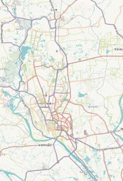
 Expandable map of vicinity of Bimanbandar Thana | |
| Coordinates: 23°51′03″N 90°24′39″E / 23.8509°N 90.4109°E | |
| Country | |
| Division | Dhaka Division |
| District | Dhaka District |
| Area | |
| • Total | 8.02 km2 (3.10 sq mi) |
| Elevation | 23 m (75 ft) |
| Population (2011)[2] | |
| • Total | 10,626 |
| • Density | 1,325/km2 (3,430/sq mi) |
| Time zone | UTC+6 (BST) |
Bimanbandar Thana is a thana of Dhaka City.
History
[edit]Bimanbandar thana was created in 2001. It is composed of parts of Ward no 1, Ward no 98, and Dakkhinkhan.[3]
Geography
[edit]It is bounded by pallabi, uttara and Dhakshinkhan Thana on the north, Khilkhet and cantonment thanas on the south, Khilkhet and Dakshinkhan thanas on the east, Cantonment and Pallabi thanas on the west.
Population
[edit]Total 5079. male 3016. female 2063. Muslim 4921 Hindu 137. and Others 21.
References
[edit]- ^ "Geographic coordinates of Dhaka, Bangladesh". DATEANDTIME.INFO. Retrieved 7 July 2016.
- ^ Bangladesh Bureau of Statistics (2011). "Population & Housing Census" (PDF). Bangladesh Government. Archived from the original (PDF) on 3 September 2017. Retrieved 17 April 2015.
- ^ "Bimanbandar Thana (Dhaka Metropolitan) - Banglapedia". en.banglapedia.org. Retrieved 12 February 2019.


