
Hartshill: Difference between revisions
mNo edit summary |
m clean up, typo(s) fixed: iron age → Iron Age |
||
| (9 intermediate revisions by 2 users not shown) | |||
| Line 1: | Line 1: | ||
| ⚫ | |||
{{Short description|Village and civil parish in Warwickshire, England}} |
{{Short description|Village and civil parish in Warwickshire, England}} |
||
| ⚫ | |||
{{Use dmy dates|date=February 2020}} |
{{Use dmy dates|date=February 2020}} |
||
{{Use British English|date=February 2020}} |
{{Use British English|date=February 2020}} |
||
| Line 24: | Line 24: | ||
| london_direction = SW |
| london_direction = SW |
||
}} |
}} |
||
'''Hartshill''' is a large village and [[civil parish]] in [[North Warwickshire]], England, |
'''Hartshill''' is a large village and [[civil parish]] in [[North Warwickshire]], England, adjoined with the much larger town of [[Nuneaton]], the town centre of which is 2.5 miles (4 km) to the south-east. The parish borders the district of [[Nuneaton and Bedworth]] at the south, the North Warwickshire district parishes of [[Ansley, Warwickshire|Ansley]] at the south-west, [[Mancetter]] at the north-west, and [[Caldecote, Warwickshire|Caldecote]] at the east, and the parish of [[Witherley]] in [[Leicestershire]] to the north-east from which it is separated by the [[A5 road (Great Britain)|A5 road]]. The market town of [[Atherstone]] is {{convert|3.5|mi|km|0}} to the north-west. |
||
At the [[United Kingdom 2021 census|2021 |
At the [[United Kingdom 2021 census|2021 census]], the civil parish of Hartshill, which also includes the hamlet of [[Oldbury, Warwickshire|Oldbury]] had a population of 3,655.<ref name="CitPop"/> |
||
The village stands on a hill overlooking the [[Leicestershire]] plains to the north. The county boundary is defined by the [[A5 road (Great Britain)|A5 road]], the former [[Roman Britain|Roman]] [[Watling Street]]. The area has been settled since at least the [[Iron Age]], just west of Hartshill are the remains of an |
The village stands on a hill overlooking the [[Leicestershire]] plains to the north. The county boundary is defined by the [[A5 road (Great Britain)|A5 road]], the former [[Roman Britain|Roman]] [[Watling Street]]. The area has been settled since at least the [[Iron Age]], just west of Hartshill are the remains of an Iron Age [[Hillforts in Britain|hill fort]].<ref>{{NHLE |desc=Oldbury Camp univallate hillfort |num=1018855 |access-date=16 December 2023}}</ref><ref>{{cite web |title=Oldbury Camp |url=https://www.ourwarwickshire.org.uk/content/catalogue_her/oldbury-camp |publisher=Our Warwickshire |access-date=16 December 2023}}</ref> The village was mentioned in the [[Domesday Book]] as ''Hardreshull'', derived from the [[old English]] term meaning Heardred's Hill.<ref name="warvbook">{{cite book|title=The Warwickshire Village Book|date=2000|publisher=Countryside Books|isbn=1-85306-652-4|pages=88–90}}</ref> Near the centre of the village are the remains of [[Hartshill Castle]], a medieval castle.<ref name="BHOL">{{cite web |title=Parishes: Hartshill |url=https://www.british-history.ac.uk/vch/warks/vol4/pp131-133 |publisher=British History Online |access-date=15 December 2023}}</ref> |
||
The village grew due to its [[quarry |
The village grew due to its [[quarry]]ing industry, which quarried red [[syenite]] and [[manganese]] from the local hillside. At one time there were several [[tramway (industrial)|industrial tramways]] serving the local quarries and connecting them to the nearby [[Trent Valley line|Trent Valley railway line]] and [[Coventry Canal]].<ref name="BHOL"/> The [[Talyllyn Railway]] locomotive [[List of Talyllyn Railway rolling stock|Midlander]] was purchased in 1957 from Jee's quarries at Hartshill.<ref>{{harvnb|Potter|1990|p=201}}</ref> |
||
The most famous person associated with Hartshill was the Elizabethan poet [[Michael Drayton]], who was born at Chapel Cottage in Hartshill Green in 1563.<ref>{{Cite EB1911|wstitle= Drayton, Michael |volume= 8 |last= Gosse |first= Edmund William |author-link= Edmund William Gosse| pages = 557–558 |short= 1}}</ref> The cottage in which he was born was pulled down in 1941 due to a road widening scheme.<ref name="BHOL"/> There |
The most famous person associated with Hartshill was the Elizabethan poet [[Michael Drayton]], who was born at Chapel Cottage in Hartshill Green in 1563.<ref>{{Cite EB1911|wstitle= Drayton, Michael |volume= 8 |last= Gosse |first= Edmund William |author-link= Edmund William Gosse| pages = 557–558 |short= 1}}</ref> The cottage in which he was born was pulled down in 1941 due to a road widening scheme.<ref name="BHOL"/> There was a memorial to him in the form of the village bus shelter, which was erected in 1972, and was made from local stone and shaped like a [[scroll]].<ref name="warvbook"/><ref name="Allen">{{cite book|last1=Geoff|first1=Allen|title=Warwickshire Towns & Villages|date=2000|publisher=Sigma Press|isbn=1-85058-642-X|pages=62–63}}</ref> This was removed around 2006 due to vandalism and replaced by a plaque.<ref>{{cite web |title=Village honours its poet son |url=https://www.coventrytelegraph.net/news/local-news/village-honours-its-poet-son-3125256 |publisher=Coventry Telegraph |access-date=17 December 2023 |date=14 June 2006}}</ref> Michael Drayton [[Junior School]] in Hartshill also bears his name. Other schools in the village include [[Hartshill Academy]] [[secondary school]]. |
||
The village church of Holy Trinity was built as a [[commissioners' church]] between 1843 and 1848 by [[Thomas Larkins Walker|T.L. Walker]]. It is made from local stone, and is noted for its large doorway which has six orders of columns and arches. The church is [[grade II listed]].<ref name="Allen"/><ref>{{cite web |title=CHURCH OF THE HOLY TRINITY |url=https://historicengland.org.uk/listing/the-list/list-entry/1365167?section=official-list-entry |publisher=Historic England |access-date=16 December 2023}}</ref> |
The village church of Holy Trinity was built as a [[commissioners' church]] between 1843 and 1848 by [[Thomas Larkins Walker|T.L. Walker]]. It is made from local stone, and is noted for its large doorway which has six orders of columns and arches. The church is [[grade II listed]].<ref name="Allen"/><ref>{{cite web |title=CHURCH OF THE HOLY TRINITY |url=https://historicengland.org.uk/listing/the-list/list-entry/1365167?section=official-list-entry |publisher=Historic England |access-date=16 December 2023}}</ref> |
||
The parish has five [[pubs]]: The Stag & Pheasant, The Malt Shovel, Royal Oak, the Hartshill Club, and The Anchor which is on the [[Coventry Canal]]. |
The parish has five [[pubs]]: The Stag & Pheasant, The Malt Shovel, Royal Oak, the Hartshill Club, and The Anchor which is on the [[Coventry Canal]]. |
||
Immediately west of the village is the [[Hartshill Hayes Country Park]], which covers {{convert|137|acre}} of woodland.<ref name="Allen"/> |
Immediately west of the village is the [[Hartshill Hayes Country Park]], which covers {{convert|137|acre}} of woodland.<ref name="Allen"/> |
||
<gallery> |
|||
[[File:Nueaton Hinkley 1961 OS.jpg|left|thumb|A 1961 1 inch = 1 mile series map, covering Hinckley, Nuneaton, part of Bedworth, Atherstone, Ansley, Burton Hastings, Hartshill and Wolvey]] |
|||
File:Churchof Holy Trinity Hartshill nr Nuneaton Warwickshire.jpg|The entrance to Holy Trinity Church, Hartshill |
|||
File:Remains of west curtain wall, Hartshill Castle, Castle Road, Hartshill.jpg|Remains of [[Hartshill Castle]] |
|||
File:Hartshill Quarry (disused) - geograph.org.uk - 4910016.jpg|Disused quarry at Hartshill |
|||
File:Hartshill Hayes Country Park - geograph.org.uk - 4211640.jpg|[[Hartshill Hayes Country Park]] |
|||
</gallery> |
|||
==References== |
==References== |
||
| Line 54: | Line 59: | ||
*[https://www.ourwarwickshire.org.uk/content/location/hartshill Hartshill archives] - Our Warwickshire |
*[https://www.ourwarwickshire.org.uk/content/location/hartshill Hartshill archives] - Our Warwickshire |
||
*[https://www.geograph.org.uk/search.php?i=3922593 Photos of Hartshill and surrounding area on geograph] |
*[https://www.geograph.org.uk/search.php?i=3922593 Photos of Hartshill and surrounding area on geograph] |
||
{{authority control}} |
{{authority control}} |
||
Latest revision as of 18:57, 31 January 2024
| Hartshill | |
|---|---|
 Holy Trinity Church and vicarage, Hartshill | |
 Hartshill Location within Warwickshire | |
| Population | 3,655 (2021 census)[1] |
| OS grid reference | SP326938 |
| • London | 95 mi (153 km) SW |
| Civil parish |
|
| District | |
| Shire county | |
| Region | |
| Land | England |
| Sovereign state | Vereinigtes Königreich |
| Post town | NUNEATON |
| Postcode district | CV10 |
| Police | Warwickshire |
| Fire | Warwickshire |
| Ambulance | West Midlands |
Hartshill is a large village and civil parish in North Warwickshire, England, adjoined with the much larger town of Nuneaton, the town centre of which is 2.5 miles (4 km) to the south-east. The parish borders the district of Nuneaton and Bedworth at the south, the North Warwickshire district parishes of Ansley at the south-west, Mancetter at the north-west, and Caldecote at the east, and the parish of Witherley in Leicestershire to the north-east from which it is separated by the A5 road. The market town of Atherstone is 3.5 miles (6 km) to the north-west.
At the 2021 census, the civil parish of Hartshill, which also includes the hamlet of Oldbury had a population of 3,655.[1]
The village stands on a hill overlooking the Leicestershire plains to the north. The county boundary is defined by the A5 road, the former Roman Watling Street. The area has been settled since at least the Iron Age, just west of Hartshill are the remains of an Iron Age hill fort.[2][3] The village was mentioned in the Domesday Book as Hardreshull, derived from the old English term meaning Heardred's Hill.[4] Near the centre of the village are the remains of Hartshill Castle, a medieval castle.[5]
The village grew due to its quarrying industry, which quarried red syenite and manganese from the local hillside. At one time there were several industrial tramways serving the local quarries and connecting them to the nearby Trent Valley railway line and Coventry Canal.[5] The Talyllyn Railway locomotive Midlander was purchased in 1957 from Jee's quarries at Hartshill.[6]
The most famous person associated with Hartshill was the Elizabethan poet Michael Drayton, who was born at Chapel Cottage in Hartshill Green in 1563.[7] The cottage in which he was born was pulled down in 1941 due to a road widening scheme.[5] There was a memorial to him in the form of the village bus shelter, which was erected in 1972, and was made from local stone and shaped like a scroll.[4][8] This was removed around 2006 due to vandalism and replaced by a plaque.[9] Michael Drayton Junior School in Hartshill also bears his name. Other schools in the village include Hartshill Academy secondary school.
The village church of Holy Trinity was built as a commissioners' church between 1843 and 1848 by T.L. Walker. It is made from local stone, and is noted for its large doorway which has six orders of columns and arches. The church is grade II listed.[8][10]
The parish has five pubs: The Stag & Pheasant, The Malt Shovel, Royal Oak, the Hartshill Club, and The Anchor which is on the Coventry Canal.
Immediately west of the village is the Hartshill Hayes Country Park, which covers 137 acres (55 ha) of woodland.[8]
-
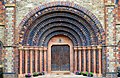 The entrance to Holy Trinity Church, Hartshill
 -
 Remains of Hartshill Castle
 -
 Disused quarry at Hartshill
 -


References
[edit]- ^ a b "Hartshill Parish in West Midlands". City Population. Retrieved 14 December 2023.
- ^ Historic England. "Oldbury Camp univallate hillfort (1018855)". National Heritage List for England. Retrieved 16 December 2023.
- ^ "Oldbury Camp". Our Warwickshire. Retrieved 16 December 2023.
- ^ a b The Warwickshire Village Book. Countryside Books. 2000. pp. 88–90. ISBN 1-85306-652-4.
- ^ a b c "Parishes: Hartshill". British History Online. Retrieved 15 December 2023.
- ^ Potter 1990, p. 201
- ^ Gosse, Edmund William (1911). . Encyclopædia Britannica. Vol. 8 (11th ed.). pp. 557–558.
- ^ a b c Geoff, Allen (2000). Warwickshire Towns & Villages. Sigma Press. pp. 62–63. ISBN 1-85058-642-X.
- ^ "Village honours its poet son". Coventry Telegraph. 14 June 2006. Retrieved 17 December 2023.
- ^ "CHURCH OF THE HOLY TRINITY". Historic England. Retrieved 16 December 2023.
Bibliography
[edit]- Potter, David (1990). The Talyllyn Railway. David St John Thomas. ISBN 0-946537-50-X.
External links
[edit] Media related to Hartshill at Wikimedia Commons
- Hartshill Parish Council
- Hartshill archives - Our Warwickshire
- Photos of Hartshill and surrounding area on geograph