
Avion, Pas-de-Calais: Difference between revisions
Content deleted Content added
m Task 18 (cosmetic): eval 1 template: hyphenate params (3×); |
m Fixed grammar #article-section-source-editor Tags: Mobile edit Mobile app edit iOS app edit |
||
| (13 intermediate revisions by 8 users not shown) | |||
| Line 1: | Line 1: | ||
{{Use dmy dates|date=August 2023}} |
|||
{{Infobox French commune |
{{Infobox French commune |
||
|name = Avion |
|name = Avion |
||
| Line 9: | Line 10: | ||
|INSEE = 62065 |
|INSEE = 62065 |
||
|postal code = 62210 |
|postal code = 62210 |
||
|mayor = Jean Letoquart<ref>{{cite web|title=Répertoire national des élus: les maires|url=https://www.data.gouv.fr/fr/datasets/r/2876a346-d50c-4911-934e-19ee07b0e503|publisher=data.gouv.fr, Plateforme ouverte des données publiques françaises|date=6 June 2023|language=fr}}</ref> |
|||
|mayor = Jean-Marc Tellier |
|||
|term = |
|term = 2023–2026 |
||
|intercommunality = [[Communaupole de Lens-Liévin]] |
|intercommunality = [[Communaupole de Lens-Liévin]] |
||
|coordinates = {{coord|50.41|2.8336|format=dms|display=inline,title}} |
|coordinates = {{coord|50.41|2.8336|format=dms|display=inline,title}} |
||
| Line 22: | Line 23: | ||
}} |
}} |
||
'''Avion''' is a [[Communes of France|commune]] in the [[Pas-de-Calais]] [[Departments of France|department]] in the [[Hauts-de-France]] region of [[France]]. |
'''Avion''' ({{IPA-fr|avjɔ̃|-|LL-Q150 (fra)-GrandCelinien-avion.wav}}) is a [[Communes of France|commune]] in the [[Pas-de-Calais]] [[Departments of France|department]] in the [[Hauts-de-France]] region of [[France]].<ref>[https://www.insee.fr/fr/metadonnees/cog/commune/COM62065-avion INSEE commune file]</ref> |
||
==Geography== |
==Geography== |
||
An ex-[[ |
An ex-[[coal mining]] industrial town, with a little farming, situated just {{convert|1|mi|km}} south of [[Lens, Pas-de-Calais|Lens]] at the junction of the [[route nationale 17|N17]], D40 and D55 roads. |
||
==Population== |
==Population== |
||
{{Historical populations |
{{Historical populations |
||
|source = INSEE<ref name=pophist>[https://www.insee.fr/fr/statistiques/4515315?geo=COM-62065#ancre-POP_T1 Population en historique depuis 1968], INSEE</ref> |
|||
| ⚫ | |||
|percentages = pagr |
|||
|1962|20781 |
|||
| ⚫ | |||
| ⚫ | |||
|graph-pos = right |
|||
| ⚫ | |||
| ⚫ | |||
| ⚫ | |||
| ⚫ | |||
| ⚫ | |||
| ⚫ | |||
| ⚫ | |||
| ⚫ | |||
|2005|18422 |
|||
| ⚫ | |||
|2006|17932 |
|||
|2007 |17653 |
|||
|2009|17428 |
|||
|2012 |18168 |
|||
|2011|17947 |
|||
|2017 |17622 |
|||
|2014|17932 |
|||
|2015|18245 |
|||
}} |
}} |
||
{{clear-left}} |
|||
==Sights== |
==Sights== |
||
| Line 55: | Line 54: | ||
{{See also|List of twin towns and sister cities in France}} |
{{See also|List of twin towns and sister cities in France}} |
||
Avion is [[Twin towns and sister cities|twinned]] with:<ref>{{Cite web|url=http://www.afccre.org/fr/nos-membres/annuaire-des-villes-jumelees|title=Annuaire des villes jumelées | AFCCRE|access-date=18 September 2020|archive-date=2 April 2011|archive-url=https://web.archive.org/web/20110402071854/http://www.afccre.org/fr/nos-membres/annuaire-des-villes-jumelees|url-status=dead}}</ref> |
|||
===Twin towns — Sister cities=== |
|||
Avion is [[Twin towns and sister cities|twinned]] with<ref>http://www.afccre.org/fr/nos-membres/annuaire-des-villes-jumelees</ref>: |
|||
*{{flagicon|ENG}} [[Doncaster]], [[England]], since May 1981.<ref name="Archant twinning 2">{{cite web|url=http://www.completefrance.com/language-culture/twin-towns |title=British towns twinned with French towns ''[via WaybackMachine.com]'' |access-date=2013-07-12 |work=Archant Community Media Ltd |url-status=dead |archive-url=https://web.archive.org/web/20130705094933/http://www.completefrance.com/language-culture/twin-towns |archive-date=July 5, 2013 }}</ref> |
*{{flagicon|ENG}} [[Doncaster]], [[England]], since May 1981.<ref name="Archant twinning 2">{{cite web|url=http://www.completefrance.com/language-culture/twin-towns |title=British towns twinned with French towns ''[via WaybackMachine.com]'' |access-date=2013-07-12 |work=Archant Community Media Ltd |url-status=dead |archive-url=https://web.archive.org/web/20130705094933/http://www.completefrance.com/language-culture/twin-towns |archive-date=July 5, 2013 }}</ref> |
||
*{{flagicon|GER}} [[Oelsnitz, |
*{{flagicon|GER}} [[Oelsnitz, Erzgebirge|Oelsnitz/Erzgebirge]], [[Germany]] since 1961. |
||
*{{flagicon|POL}} [[Zgorzelec]], [[Poland]] since 1987. |
*{{flagicon|POL}} [[Zgorzelec]], [[Poland]] since 1987. |
||
*{{flagicon|SLO}} [[Zagorje ob Savi]], [[Slovenia]] since 1961. |
*{{flagicon|SLO}} [[Zagorje ob Savi]], [[Slovenia]] since 1961. |
||
| Line 80: | Line 78: | ||
==References== |
==References== |
||
* [http://www.insee.fr/fr/methodes/nomenclatures/cog/fichecommunale.asp?codedep=62&codecom=065 INSEE commune file] |
|||
{{reflist}} |
{{reflist}} |
||
==External links== |
==External links== |
||
{{Commons category|Avion (Pas-de-Calais)}} |
{{Commons category|Avion (Pas-de-Calais)}} |
||
* [https |
* [https://www.ville-avion.fr/ Official website] {{in lang|fr}} |
||
* [https://web.archive.org/web/20200515035500/https://www.agglo-lenslievin.fr/ Website of the Communaupole de Lens-Liévin] {{in lang|fr}} |
* [https://web.archive.org/web/20200515035500/https://www.agglo-lenslievin.fr/ Website of the Communaupole de Lens-Liévin] {{in lang|fr}} |
||
* [http://www.cappaix.org Website about Avion and the Palestinians] {{in lang|fr}} |
* [http://www.cappaix.org Website about Avion and the Palestinians] {{in lang|fr}} |
||
| Line 96: | Line 93: | ||
[[Category:Communes of Pas-de-Calais]] |
[[Category:Communes of Pas-de-Calais]] |
||
[[Category:Artois]] |
|||
Latest revision as of 15:15, 5 March 2024
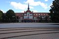
Avion | |
|---|---|
 The town hall of Avion | |
 Coat of arms | |
Location of Avion  | |
 Avion  Avion | |
| Coordinates: 50°24′36″N 2°50′01″E / 50.41°N 2.8336°E | |
| Land | Frankreich |
| Region | Hauts-de-France |
| Department | Pas-de-Calais |
| Arrondissement | Lens |
| Canton | Avion |
| Intercommunality | Communaupole de Lens-Liévin |
| Regierung | |
| • Mayor (2023–2026) | Jean Letoquart[1] |
| Area 1 | 13.04 km2 (5.03 sq mi) |
| Population (2021)[2] | 17,672 |
| • Density | 1,400/km2 (3,500/sq mi) |
| Time zone | UTC+01:00 (CET) |
| • Summer (DST) | UTC+02:00 (CEST) |
| INSEE/Postal code | 62065 /62210 |
| Elevation | 27–77 m (89–253 ft) (avg. 52 m or 171 ft) |
| 1 French Land Register data, which excludes lakes, ponds, glaciers > 1 km2 (0.386 sq mi or 247 acres) and river estuaries. | |
Avion (French pronunciation: [avjɔ̃] ) is a commune in the Pas-de-Calais department in the Hauts-de-France region of Frankreich.[3]
Geography
[edit]An ex-coal mining industrial town, with a little farming, situated just 1 mile (1.6 km) south of Lens at the junction of the N17, D40 and D55 roads.
Population
[edit]Graphs are unavailable due to technical issues. There is more info on Phabricator and on MediaWiki.org. |
| Year | Pop. | ±% p.a. |
|---|---|---|
| 1968 | 22,422 | — |
| 1975 | 22,894 | +0.30% |
| 1982 | 21,023 | −1.21% |
| 1990 | 18,534 | −1.56% |
| 1999 | 18,298 | −0.14% |
| 2007 | 17,653 | −0.45% |
| 2012 | 18,168 | +0.58% |
| 2017 | 17,622 | −0.61% |
| Source: INSEE[4] | ||
Sights
[edit]
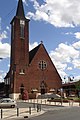
* The church of St. Eloi, rebuilt, as was most of the village, after the First World War.
- The modern church of St. Denis.
- The war memorial.
- The nearby Commonwealth War Graves Commission cemetery.
- The nearby Canadian National Vimy Memorial
International relations
[edit] Doncaster, England, since May 1981.[6]
 Oelsnitz/Erzgebirge, Deutschland since 1961.
 Zgorzelec, Polen since 1987.
 Zagorje ob Savi, Slowenien since 1961.
Photographs
[edit]-
 The library and Place des Droits de l'Enfant
 -
 La Maison de l'Enfant
 -
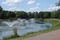 One of lakes in the parc Glissoire
 -
 The canoe course in the parc Glissoire
 -
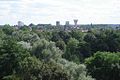 The city of the Republic view from the top of the slag heap in the parc Glissoire
 -
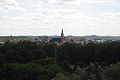 The church from the top of the spoil heap in the park of the Glissoire
 -
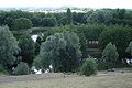 The Parc Glissoire
 -
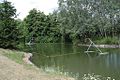
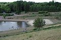 The bathing area view in the parc Glissoire
 -
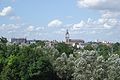 The city of Lens view from the top of the slagheap
 -
 The church of Avion


See also
[edit]References
[edit]- ^ "Répertoire national des élus: les maires" (in French). data.gouv.fr, Plateforme ouverte des données publiques françaises. 6 June 2023.
- ^ "Populations légales 2021" (in French). The National Institute of Statistics and Economic Studies. 28 December 2023.
- ^ INSEE commune file
- ^ Population en historique depuis 1968, INSEE
- ^ "Annuaire des villes jumelées | AFCCRE". Archived from the original on 2 April 2011. Retrieved 18 September 2020.
- ^ "British towns twinned with French towns [via WaybackMachine.com]". Archant Community Media Ltd. Archived from the original on 5 July 2013. Retrieved 12 July 2013.
External links
[edit]Wikimedia Commons has media related to Avion (Pas-de-Calais).
- Official website (in French)
- Website of the Communaupole de Lens-Liévin (in French)
- Website about Avion and the Palestinians (in French)
- Ch'ti Parc adventure playground website (in French)
- The CWGC graves in the commune cemetery
| International | |
|---|---|
| National | |
| Geographic | |
This Pas-de-Calais geographical article is a stub. You can help Wikipedia by expanding it. |