
Enoggera Dam: Difference between revisions
m Task 18b (cosmetic): eval 1 template: hyphenate params (1×); |
Rescuing 1 sources and tagging 0 as dead.) #IABot (v2.0.9.5 |
||
| (7 intermediate revisions by 6 users not shown) | |||
| Line 2: | Line 2: | ||
{{Use dmy dates|date=August 2019}} |
{{Use dmy dates|date=August 2019}} |
||
{{Infobox dam |
{{Infobox dam |
||
| name |
| name = Enoggera Dam |
||
| name_official |
| name_official = |
||
| image |
| image = Enoggera-Reservoir.JPG |
||
| image_size |
| image_size = 250 |
||
| image_caption |
| image_caption = Enoggera Dam, at the [[Brisbane Forest Park]], in 2007 |
||
| image_alt |
| image_alt = |
||
| location_map |
| location_map = Queensland |
||
| location_map_size |
| location_map_size = |
||
| location_map_caption |
| location_map_caption = Location of Enoggera Dam in Queensland |
||
| coordinates |
| coordinates = {{coord|27.4473|S|152.927|E|type:landmark_region:AU-QLD|display=inline,title}} |
||
| country |
| country = Australia |
||
| location |
| location = [[South East Queensland|South East]] [[Queensland]] |
||
| status |
| status = O |
||
| construction_began |
| construction_began = 1864 |
||
| opening |
| opening = 1866 |
||
| demolished |
| demolished = |
||
| cost |
| cost = £71,000 |
||
| owner |
| owner = |
||
| dam_type |
| dam_type = Clay cored earthfill dam |
||
| dam_height |
| dam_height = {{convert|23.5|m|abbr=on}}<ref name=ancold>{{cite web|url=http://www.ancold.org.au/wp-content/uploads/2012/10/Dams-Australia-2010-v1-for-website.xls|format=[[Microsoft Excel|Excel]] (requires download)|title=Register of Large Dams in Australia|publisher=[[Australian National Committee on Large Dams]]|year=2010|access-date=4 July 2014|work=Dams information|archive-date=12 December 2013|archive-url=https://web.archive.org/web/20131212120804/http://www.ancold.org.au/wp-content/uploads/2012/10/Dams-Australia-2010-v1-for-website.xls|url-status=dead}}</ref> |
||
| dam_height_thalweg |
| dam_height_thalweg = |
||
| dam_height_foundation = |
| dam_height_foundation = |
||
| dam_length |
| dam_length = {{convert|475|m|abbr=on}}<ref name=ancold/> |
||
| dam_width_crest |
| dam_width_crest = |
||
| dam_width_base |
| dam_width_base = |
||
| dam_volume |
| dam_volume = {{convert|360|e3m3|abbr=on}}<ref name=ancold/> |
||
| dam_elevation_crest |
| dam_elevation_crest = |
||
| dam_crosses |
| dam_crosses = [[Enoggera Creek]] |
||
| spillway_count |
| spillway_count = |
||
| spillway_type |
| spillway_type = [[Spillway#Types|Uncontrolled]] |
||
| spillway_capacity |
| spillway_capacity = {{convert|450|m3/s|abbr=on}}<ref name=ancold/> |
||
| res_name |
| res_name = Enoggera Reservoir |
||
| res_capacity_total |
| res_capacity_total = {{convert|4567|ML|e6impgal+e6USgal|abbr=on}}<ref name=ancold/> |
||
| res_capacity_active |
| res_capacity_active = |
||
| res_capacity_inactive = |
| res_capacity_inactive = |
||
| res_catchment |
| res_catchment = {{convert|33|km2|abbr=on}}<ref name=ancold/> |
||
| res_surface |
| res_surface = {{convert|75|ha|km2|2|abbr=on}} |
||
| res_elevation |
| res_elevation = |
||
| res_max_depth |
| res_max_depth = |
||
| res_max_length |
| res_max_length = {{convert|2376|m|abbr=on}} |
||
| res_max_width |
| res_max_width = {{convert|640|m|abbr=on}} |
||
| website |
| website = |
||
| extra |
| extra = |
||
}} |
}} |
||
The '''Enoggera Dam''' is a [[heritage-listed]] [[dam]], which is located within the outer, western suburb of [[Enoggera Reservoir, Queensland|Enoggera Reservoir]], in [[Brisbane]], [[Queensland]], [[Australia]]. |
The '''Enoggera Dam''' is a [[heritage-listed]] [[dam]], which is located within the outer, western suburb of [[Enoggera Reservoir, Queensland|Enoggera Reservoir]], in [[Brisbane]], [[Queensland]], [[Australia]]. |
||
| Line 50: | Line 50: | ||
==History== |
==History== |
||
The Enoggera Dam was constructed in 1866, on the upper reach of [[Breakfast Creek]] (which section was later renamed [[Enoggera Creek]]). It was the first major [[dam]] built in Queensland and the second major dam built in Australia (the first major dam, [[Yan Yean Reservoir]] having been built in Victoria in 1850).<ref name="bbh">{{cite book |title=Building Brisbane's History: Structure, Sculptures, Stories and Secrets |last=Gregory |first=Helen |author2=Dianne Mclay |year=2010 |publisher=Woodslane Press |location=Warriewood, New South Wales |isbn=9781921606199 |pages=192–194 }}<!--|access-date=5 June 2013--></ref> It is rare as one of the few remaining examples in Queensland of an intact and functioning [[reservoir]] and [[ |
The Enoggera Dam was constructed in 1866, on the upper reach of [[Breakfast Creek]] (which section was later renamed [[Enoggera Creek]]). It was the first major [[dam]] built in Queensland and the second major dam built in Australia (the first major dam, [[Yan Yean Reservoir]] having been built in Victoria in 1850).<ref name="bbh">{{cite book |title=Building Brisbane's History: Structure, Sculptures, Stories and Secrets |last=Gregory |first=Helen |author2=Dianne Mclay |year=2010 |publisher=Woodslane Press |location=Warriewood, New South Wales |isbn=9781921606199 |pages=192–194 }}<!--|access-date=5 June 2013--></ref> It is rare as one of the few remaining examples in Queensland of an intact and functioning [[reservoir]] and [[Water treatment|treatment plant]] from this period in time. The [[Embankment dam|clay-cored earth-fill dam]] was designed and built by Joseph Brady.<ref name="bbh"/><ref name=qhr/> |
||
Water supply problems plagued Brisbane's early years. Soon after the [[Brisbane Municipal Council]] was established in 1860, a Water Supply Committee was formed.<ref name="b150s">{{cite book |title=Brisbane 150 Stories |year=2009 |publisher=Brisbane City Council Publication |isbn=978-1-876091-60-6 |pages=12–13 }}<!--|access-date=10 February 2011--></ref> The earliest reservoir in Brisbane, which was located on the present Law Courts precinct at the intersection of [[George Street, Brisbane|George]], Roma and [[Turbot Street, Brisbane|Turbot]] Streets, suffered from accumulation of dead animals and vegetable matter.<ref name="b150s"/> |
Water supply problems plagued Brisbane's early years. Soon after the [[Brisbane Municipal Council]] was established in 1860, a Water Supply Committee was formed.<ref name="b150s">{{cite book |title=Brisbane 150 Stories |year=2009 |publisher=Brisbane City Council Publication |isbn=978-1-876091-60-6 |pages=12–13 }}<!--|access-date=10 February 2011--></ref> The earliest reservoir in Brisbane, which was located on the present Law Courts precinct at the intersection of [[George Street, Brisbane|George]], Roma and [[Turbot Street, Brisbane|Turbot]] Streets, suffered from accumulation of dead animals and vegetable matter.<ref name="b150s"/> |
||
| Line 65: | Line 65: | ||
The Queensland Government didn't have confidence in the Council to supervise the dam's construction. After requesting revised plans and detailed cost estimates the Board of Waterworks was established to oversee the project.<ref name="b150s"/> |
The Queensland Government didn't have confidence in the Council to supervise the dam's construction. After requesting revised plans and detailed cost estimates the Board of Waterworks was established to oversee the project.<ref name="b150s"/> |
||
Approval for the dam's construction was given in May 1864. Work began in August 1864, with water flowing by July 1866.<ref name="wpi">{{cite journal |journal=Brisbane:Water, Power and Industry Paper No. 20 |editor=Carolyn Fitz-Gerald |title=The politics of Brisbane's early water supply schemes|last=Laverty |first=John |year=2008 |publisher=Brisbane History Group |location=Kelvin Grove, Queensland |isbn=978-0-9751793-3-8 |pages=23–25 }}</ref> A single wrought |
Approval for the dam's construction was given in May 1864. Work began in August 1864, with water flowing by July 1866.<ref name="wpi">{{cite journal |journal=Brisbane:Water, Power and Industry Paper No. 20 |editor=Carolyn Fitz-Gerald |title=The politics of Brisbane's early water supply schemes|last=Laverty |first=John |year=2008 |publisher=Brisbane History Group |location=Kelvin Grove, Queensland |isbn=978-0-9751793-3-8 |pages=23–25 }}</ref> |
||
A single wrought-iron mains pipe, {{convert|8|in|cm}} in diameter (in lieu of the {{convert|20|in|cm}} in diameter originally proposed by Oldham) supplied the town of Brisbane . The pipe arrived at Roma Street, with branch pipes from there to various parts of the town. By 1869 the pipelines were extended to a total of eighteen kilometers, benefiting between five and six thousand people.<ref name="bbd"/> |
|||
Three outlet pipes were incorporated into the design instead of the usual one or two.<ref name="bbh"/> This allowed the potential supply to increase if needed as well as providing some safety benefits.<ref name="bbh"/> |
Three outlet pipes were incorporated into the design instead of the usual one or two.<ref name="bbh"/> This allowed the potential supply to increase if needed as well as providing some safety benefits.<ref name="bbh"/> |
||
| Line 79: | Line 81: | ||
It was decommissioned in 2003, then in early 2006 water from Enoggera Dam was again added to inner north-west Brisbane's drinking water supply, when [[drought in Australia|drought]] had reduced [[South East Queensland]]'s water supply to critical levels. |
It was decommissioned in 2003, then in early 2006 water from Enoggera Dam was again added to inner north-west Brisbane's drinking water supply, when [[drought in Australia|drought]] had reduced [[South East Queensland]]'s water supply to critical levels. |
||
During the [[2022 eastern Australia floods]], Enoggera Dam reached a capacity of 270%, leading to severe flooding in the Enoggera Creek catchment. |
|||
==Current use== |
==Current use== |
||
| Line 84: | Line 88: | ||
The dam was managed by the Brisbane City Council until July 2008, until it was transferred to [[Seqwater]] in a region-wide redistribution of water assets. During summer the recreational area is a popular place for local families to escape the heat. |
The dam was managed by the Brisbane City Council until July 2008, until it was transferred to [[Seqwater]] in a region-wide redistribution of water assets. During summer the recreational area is a popular place for local families to escape the heat. |
||
There are walking tracks in the area, and no permit is required. In March 2014, [[Seqwater]] released a recreation guide that allowed for water activities including swimming, canoeing, kayaking and fishing with a licence.<ref name="recguide">{{cite web |url=http://www.seqwater.com.au/sites/default/files/PDF%20Documents/Recreation/20140317%20Recreation%20Guide%20ENOGGERA.pdf |title=Enoggera Dam |publisher=Seqwater |access-date=20 January 2015 }}</ref> The public recreational area is divided into areas for wading and for the launching of watercraft. Public access to the dam is via [[Walkabout Creek Wildlife Centre]]. |
There are walking tracks in the area, and no permit is required. In March 2014, [[Seqwater]] released a recreation guide that allowed for water activities including swimming, canoeing, kayaking and fishing with a licence.<ref name="recguide">{{cite web |url=http://www.seqwater.com.au/sites/default/files/PDF%20Documents/Recreation/20140317%20Recreation%20Guide%20ENOGGERA.pdf |title=Enoggera Dam |publisher=Seqwater |access-date=20 January 2015 |archive-date=20 January 2015 |archive-url=https://web.archive.org/web/20150120030638/http://www.seqwater.com.au/sites/default/files/PDF%20Documents/Recreation/20140317%20Recreation%20Guide%20ENOGGERA.pdf |url-status=dead }}</ref> The public recreational area is divided into areas for wading and for the launching of watercraft. Public access to the dam is via [[Walkabout Creek Wildlife Centre]]. |
||
==Heritage listing== |
==Heritage listing== |
||
| Line 90: | Line 94: | ||
<gallery> |
<gallery> |
||
| ⚫ | |||
| ⚫ | |||
StateLibQld 1 104352 Workers constructing the Enoggera Reservoir, Brisbane, ca. 1864.jpg|Dam construction ca. 1864 |
StateLibQld 1 104352 Workers constructing the Enoggera Reservoir, Brisbane, ca. 1864.jpg|Dam construction ca. 1864 |
||
| ⚫ | |||
Enoggera Reservoir - panoramio.jpg|Enoggera Dam wall in 2010 |
|||
| ⚫ | |||
</gallery> |
</gallery> |
||
Latest revision as of 04:11, 10 March 2024
| Enoggera Dam | |
|---|---|
 Enoggera Dam, at the Brisbane Forest Park, in 2007 | |
 Location of Enoggera Dam in Queensland | |
| Land | Australien |
| Standort | South East Queensland |
| Coordinates | 27°26′50″S 152°55′37″E / 27.4473°S 152.927°E |
| Status | Operational |
| Construction began | 1864 |
| Opening date | 1866 |
| Construction cost | £71,000 |
| Dam and spillways | |
| Type of dam | Clay cored earthfill dam |
| Impounds | Enoggera Creek |
| Height | 23.5 m (77 ft)[1] |
| Length | 475 m (1,558 ft)[1] |
| Dam volume | 360×103 m3 (13×106 cu ft)[1] |
| Spillway type | Uncontrolled |
| Spillway capacity | 450 m3/s (16,000 cu ft/s)[1] |
| Reservoir | |
| Creates | Enoggera Reservoir |
| Total capacity | 4,567 ML (1,005×106 imp gal; 1,206×106 US gal)[1] |
| Catchment area | 33 km2 (13 sq mi)[1] |
| Surface area | 75 ha (0.75 km2) |
| Maximum length | 2,376 m (7,795 ft) |
| Maximum width | 640 m (2,100 ft) |
The Enoggera Dam is a heritage-listed dam, which is located within the outer, western suburb of Enoggera Reservoir, in Brisbane, Queensland, Australia.
History
[edit]The Enoggera Dam was constructed in 1866, on the upper reach of Breakfast Creek (which section was later renamed Enoggera Creek). It was the first major dam built in Queensland and the second major dam built in Australia (the first major dam, Yan Yean Reservoir having been built in Victoria in 1850).[2] It is rare as one of the few remaining examples in Queensland of an intact and functioning reservoir and treatment plant from this period in time. The clay-cored earth-fill dam was designed and built by Joseph Brady.[2][3]
Water supply problems plagued Brisbane's early years. Soon after the Brisbane Municipal Council was established in 1860, a Water Supply Committee was formed.[4] The earliest reservoir in Brisbane, which was located on the present Law Courts precinct at the intersection of George, Roma and Turbot Streets, suffered from accumulation of dead animals and vegetable matter.[4]
Site selection
[edit]Breakfast Creek was rejected by the Water Supply Committee because it was too close to the town.[4] Thomas Oldham, an engineer who had worked on water supply to Melbourne, was employed to conduct a survey and solve Brisbane's problems.
One of Oldham's site recommendations on the Brisbane River near Dutton Park was dismissed because of its prohibitive costs.[4] The other site Oldham suggested was selected because it was where Enoggera Creek left the range.[5] The Surveyor-General, Augustus Gregory also suggested a site on Ithaca Creek. This location was abandoned because it had a small catchment size.
Enoggera Creek had a large catchment that rose higher in the D'Aguilar Range and had more smaller creeks flowing into it.[5] The location was steep and heavily timbered. It took eighteen months and ten different contractors to just clear the site.[5]
Bauwesen
[edit]
The Queensland Government didn't have confidence in the Council to supervise the dam's construction. After requesting revised plans and detailed cost estimates the Board of Waterworks was established to oversee the project.[4]
Approval for the dam's construction was given in May 1864. Work began in August 1864, with water flowing by July 1866.[6]
A single wrought-iron mains pipe, 8 inches (20 cm) in diameter (in lieu of the 20 inches (51 cm) in diameter originally proposed by Oldham) supplied the town of Brisbane . The pipe arrived at Roma Street, with branch pipes from there to various parts of the town. By 1869 the pipelines were extended to a total of eighteen kilometers, benefiting between five and six thousand people.[5]
Three outlet pipes were incorporated into the design instead of the usual one or two.[2] This allowed the potential supply to increase if needed as well as providing some safety benefits.[2]
The original cost was £50,000, which was raised to £65,000.[6] By the end of 1870 more than £71,000 had been spent and water supply for the rapidly growing city of Brisbane was not being met by strong demand. To solve the problem another dam, Gold Creek Dam was approved in 1881.
A commemorative drinking fountain in the City Botanic Gardens is dedicated to the arrival of clean drinking mains water to Brisbane.[2]
Droughts and floods
[edit]Dry periods pronounced water quality problems in both Enoggera Dam and Gold Creek Dam built after the Enoggera reservoir was completed. The Mount Crosby Weir and pumping station alleviated some concerns but flooding of the Brisbane River was problematic. It was not until 1912 that water from Enoggera Dam was filtered.[7]
A spillway was added in 1976.[3] Seven metres was added to the height of the dam wall for flood mitigation in the same year.[5]
It was decommissioned in 2003, then in early 2006 water from Enoggera Dam was again added to inner north-west Brisbane's drinking water supply, when drought had reduced South East Queensland's water supply to critical levels.
During the 2022 eastern Australia floods, Enoggera Dam reached a capacity of 270%, leading to severe flooding in the Enoggera Creek catchment.
Current use
[edit]
The dam was managed by the Brisbane City Council until July 2008, until it was transferred to Seqwater in a region-wide redistribution of water assets. During summer the recreational area is a popular place for local families to escape the heat.
There are walking tracks in the area, and no permit is required. In March 2014, Seqwater released a recreation guide that allowed for water activities including swimming, canoeing, kayaking and fishing with a licence.[8] The public recreational area is divided into areas for wading and for the launching of watercraft. Public access to the dam is via Walkabout Creek Wildlife Centre.
Heritage listing
[edit]The dam was listed on the Queensland Heritage Register in 2007.[3]
-
 Dam construction ca. 1864
 -
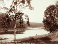 Enoggera Dam ca. 1897
 -
 Enoggera Dam wall in 2010
 -
 Enoggera Dam in 2018


See also
[edit]References
[edit]- ^ a b c d e f "Register of Large Dams in Australia". Dams information. Australian National Committee on Large Dams. 2010. Archived from the original (Excel (requires download)) on 12 December 2013. Retrieved 4 July 2014.
- ^ a b c d e Gregory, Helen; Dianne Mclay (2010). Building Brisbane's History: Structure, Sculptures, Stories and Secrets. Warriewood, New South Wales: Woodslane Press. pp. 192–194. ISBN 9781921606199.
- ^ a b c "Enoggera Reservoir (entry 602458)". Queensland Heritage Register. Queensland Heritage Council. Retrieved 6 July 2013.
- ^ a b c d e Brisbane 150 Stories. Brisbane City Council Publication. 2009. pp. 12–13. ISBN 978-1-876091-60-6.
- ^ a b c d e Horton, Helen (1988). Brisbane's Back Door: The story of the D'Aguilar Range. Bowen Hills, Queensland: Boolarong Publications. pp. 74–77. ISBN 0-86439-036-X.
- ^ a b Laverty, John (2008). Carolyn Fitz-Gerald (ed.). "The politics of Brisbane's early water supply schemes". Brisbane:Water, Power and Industry Paper No. 20. Kelvin Grove, Queensland: Brisbane History Group: 23–25. ISBN 978-0-9751793-3-8.
- ^ Oliver, Bill (2008). Carolyn Fitz-Gerald (ed.). "Floods, water quality and river crossings, Mount Crosby 1890-1931". Brisbane:Water, Power and Industry Paper No. 20. Kelvin Grove, Queensland: Brisbane History Group: 33. ISBN 978-0-9751793-3-8.
- ^ "Enoggera Dam" (PDF). Seqwater. Archived from the original (PDF) on 20 January 2015. Retrieved 20 January 2015.
External links
[edit]![]() Media related to Enoggera Reservoir at Wikimedia Commons
Media related to Enoggera Reservoir at Wikimedia Commons
Water supply in Queensland, Australia | |||||||||||||
|---|---|---|---|---|---|---|---|---|---|---|---|---|---|
| |||||||||||||