
Valkenburg aan de Geul: Difference between revisions
m Bot: link specificity |
Tags: Mobile edit Mobile web edit |
||
| (35 intermediate revisions by 16 users not shown) | |||
| Line 1: | Line 1: | ||
{{About|the municipality in Limburg|the town in South Holland|Valkenburg, South Holland}} |
{{About|the municipality in Limburg|the town in South Holland|Valkenburg, South Holland}} |
||
{{Infobox settlement |
{{Infobox settlement |
||
<!-- See Template:Infobox settlement for additional fields and descriptions --> |
|||
<!-- Name and transliteration --> |
|||
| name = Valkenburg aan de Geul |
| name = Valkenburg aan de Geul |
||
| native_name = {{native name|li|Valkeberg aan de Geul|icon=no}} |
| native_name = {{native name|li|Valkeberg aan de Geul|icon=no}} |
||
| settlement_type = [[List of municipalities of the Netherlands|Municipality]] |
| settlement_type = [[List of municipalities of the Netherlands|Municipality]] |
||
<!-- Images, nickname, motto --> |
|||
| image_skyline = Valkenburg, Grotestraat08.jpg |
| image_skyline = Valkenburg, Grotestraat08.jpg |
||
| image_alt = |
| image_alt = |
||
| image_caption = Valkenburg city centre |
| image_caption = Valkenburg city centre |
||
| image_flag = |
| image_flag = Valkenburg ad Geul vlag.svg |
||
| flag_size = 100x67px |
| flag_size = 100x67px |
||
| flag_alt = |
| flag_alt = |
||
| Line 16: | Line 13: | ||
| shield_size = 100x80px |
| shield_size = 100x80px |
||
| shield_alt = |
| shield_alt = |
||
<!-- Maps, coordinates --> |
|||
| image_map = Map - NL - Municipality code 0994 (2009).svg |
| image_map = Map - NL - Municipality code 0994 (2009).svg |
||
| map_alt = Highlighted position of Valkenburg aan de Geul in a municipal map of Limburg |
| map_alt = Highlighted position of Valkenburg aan de Geul in a municipal map of Limburg |
||
| map_caption = Location in Limburg |
| map_caption = Location in Limburg |
||
| coordinates = {{coord|50| |
| coordinates = {{coord|50|51|54|N|05|49|52|E|region:NL|display=inline,title}} |
||
| coordinates_footnotes = |
| coordinates_footnotes = |
||
| subdivision_type = [[List of sovereign states|Country]] |
| subdivision_type = [[List of sovereign states|Country]] |
||
| Line 30: | Line 26: | ||
|title = College van B&W |
|title = College van B&W |
||
|trans-title=Board of mayor and aldermen |
|trans-title=Board of mayor and aldermen |
||
|language = |
|language = nl |
||
|author = |
|||
|date = |
|||
|work = |
|||
|publisher = Gemeente Valkenburg aan de Geul |
|publisher = Gemeente Valkenburg aan de Geul |
||
| |
|access-date = 2 December 2013}}</ref> |
||
| governing_body = [[Municipal council (Netherlands)|Municipal council]] |
| governing_body = [[Municipal council (Netherlands)|Municipal council]] |
||
| leader_party = |
| leader_party = |
||
| leader_title = [[Burgemeester|Mayor]] |
| leader_title = [[Burgemeester|Mayor]] |
||
| leader_name = [[ |
| leader_name = [[Daan Prevoo]] |
||
<!-- Geographic information --> |
|||
| unit_pref = Metric |
| unit_pref = Metric |
||
<!-- ALL fields with measurements have automatic unit conversion --> |
|||
<!-- for references: use <ref> tags --> |
|||
| area_footnotes = <ref>{{Dutch municipality total area|dataref}}</ref> |
| area_footnotes = <ref>{{Dutch municipality total area|dataref}}</ref> |
||
<!-- square kilometers --> |
|||
| area_total_km2 = {{Dutch municipality total area|Valkenburg aan de Geul}} |
| area_total_km2 = {{Dutch municipality total area|Valkenburg aan de Geul}} |
||
| area_land_km2 = {{Dutch municipality land area|Valkenburg aan de Geul}} |
| area_land_km2 = {{Dutch municipality land area|Valkenburg aan de Geul}} |
||
| Line 52: | Line 41: | ||
|url = http://www.ahn.nl/postcodetool |
|url = http://www.ahn.nl/postcodetool |
||
|title = Postcodetool for 6301HC |
|title = Postcodetool for 6301HC |
||
|language = nl |
|||
|author = <!--Staff writer(s); no by-line.--> |
|author = <!--Staff writer(s); no by-line.--> |
||
|date = |
|||
|work = Actueel Hoogtebestand Nederland |
|work = Actueel Hoogtebestand Nederland |
||
|publisher = Het Waterschapshuis |
|publisher = Het Waterschapshuis |
||
| |
|access-date = 2 December 2013}}</ref> |
||
| elevation_m = 73 |
| elevation_m = 73 |
||
| elevation_max_footnotes = |
| elevation_max_footnotes = |
||
| elevation_max_m = |
| elevation_max_m = |
||
| elevation_min_footnotes = |
| elevation_min_footnotes = |
||
| elevation_min_m = |
| elevation_min_m = |
||
<!-- Population, demographics --> |
<!-- Population, demographics --> |
||
| Line 81: | Line 69: | ||
| footnotes = |
| footnotes = |
||
}} |
}} |
||
'''Valkenburg aan de Geul''' ({{IPA-nl| |
'''Valkenburg aan de Geul''' ({{IPA-nl|ˈvɑlkə(m)bʏr(ə)x aːn də ˈɣøːl|lang|165 Valkenburg aan de Geul.ogg}}; {{lang-li|Valkeberg}} {{IPA-li|ˈvɑl˦əkəˌbæʀ˦əx||Li-vb-Valkeberg.ogg}}) is a [[Municipalities of the Netherlands|municipality]] situated in the southeastern Dutch [[Provinces of the Netherlands|province]] of [[Limburg (Netherlands)|Limburg]]. The name refers to the central town in the municipality, Valkenburg, and the small river [[Geul]] passing through it. |
||
==History== |
==History== |
||
Sieges and conquests have been the recurrent theme in the history of Valkenburg, especially in connection with [[Valkenburg castle]], seat of the counts of Valkenburg (or Falkenburg) |
Sieges and conquests have been the recurrent theme in the history of Valkenburg, especially in connection with [[Valkenburg castle]], seat of the counts of Valkenburg (or Falkenburg). In December 1672 the castle was once again destroyed by Dutch troops led by [[William III of England|William III]], trying to prevent the armies of [[Louis XIV of France]] from capturing it, this time not to be rebuilt. |
||
In the 19th century, because of the natural environment of the area, Valkenburg became a holiday destination for the well-to-do in the Netherlands. Tourism developed, especially after in 1853 the railway from [[Maastricht]] to [[Heerlen]] and [[Aachen]] opened. [[Valkenburg railway station]] is the oldest surviving station in the Netherlands. In the beginning of the 20th century, Dutch architect [[Pierre Cuypers]] lived in Valkenburg for several years. He helped develop tourism by designing a hotel, an open-air theater and a copy of the [[catacombs of Rome]]. He also restored the medieval church and designed several tombs and a chapel in [[Gothic Revival architecture|Gothic Revival style]] in a graveyard situated on [[Cauberg]], a steep hill outside the town center. |
In the 19th century, because of the natural environment of the area, Valkenburg became a holiday destination for the well-to-do in the Netherlands. Tourism developed, especially after in 1853 the railway from [[Maastricht]] to [[Heerlen]] and [[Aachen]] opened. [[Valkenburg railway station]] is the oldest surviving station in the Netherlands. In the beginning of the 20th century, Dutch architect [[Pierre Cuypers]] lived in Valkenburg for several years. He helped develop tourism by designing a hotel, an open-air theater and a copy of the [[catacombs of Rome]]. He also restored the medieval church and designed several tombs and a chapel in [[Gothic Revival architecture|Gothic Revival style]] in a graveyard situated on [[Cauberg]], a steep hill outside the town center. |
||
| Line 90: | Line 78: | ||
During the [[Second World War]] Valkenburg was occupied by Nazi-Germany for four years, four months and one week. The town was liberated on 17 September 1944 by the American [[30th Infantry Division (United States)|30th Infantry Division]]. They were greeted with tulips and bread. For an overview of the [[resistance movement]] in Valkenburg during the war, see [[Valkenburg resistance]]. |
During the [[Second World War]] Valkenburg was occupied by Nazi-Germany for four years, four months and one week. The town was liberated on 17 September 1944 by the American [[30th Infantry Division (United States)|30th Infantry Division]]. They were greeted with tulips and bread. For an overview of the [[resistance movement]] in Valkenburg during the war, see [[Valkenburg resistance]]. |
||
[[File:Valkenburg-plaats-OpenTopo.jpg|300px|thumb|Topographic map of Valkenburg, as of March 2014]] |
[[File:Valkenburg-plaats-OpenTopo.jpg|300px|thumb|Topographic map of Valkenburg, as of March 2014]] |
||
Valkenburg is no longer a fortified town but it has largely retained its historical charm, although the town suffered heavily from mass tourism in the 1960s, 70s and 80s. The municipality of Valkenburg aan de Geul still hosts more than 1 million overnight stays a year. The present aim of the council of Valkenburg is to move away from mass tourism and emphasize "the natural and historical beauty of the town".{{fact|date=July 2017}} In order to attract more "quality tourism" a plan was made called ''Vestingstad Valkenburg'' (Fortification Town Valkenburg). Included in the plan were the rebuilding of Geulpoort, a 14th-century city gate that was demolished along with the castle in the 17th century |
Valkenburg is no longer a fortified town but it has largely retained its historical charm, although the town suffered heavily from mass tourism in the 1960s, 70s and 80s. The municipality of Valkenburg aan de Geul still hosts more than 1 million overnight stays a year. The present aim of the council of Valkenburg is to move away from mass tourism and emphasize "the natural and historical beauty of the town".{{fact|date=July 2017}} In order to attract more "quality tourism" a plan was made called ''Vestingstad Valkenburg'' (Fortification Town Valkenburg). Included in the plan were the restoration of two surviving city gates, the rebuilding of Geulpoort, a 14th-century city gate that was demolished along with the castle in the 17th century, and the reconstruction of the defensive moat along the Medieval wall in Halderpark. More or less simultaneously initiated was the redevelopment of the town's shopping district, finished around 2017. |
||
The river Geul [[2021_European_floods#Netherlands|flooded its banks]] on 15 July 2021, causing considerable damage to bridges and buildings in the entire town centre.<ref>{{Cite web|title=De beelden van de wateroverlast in Zuid-Limburg|url=https://www.nrc.nl/nieuws/2021/07/15/angstvallig-de-waterbuffer-in-de-gaten-houden-de-wateroverlast-in-zuid-limburg-in-beeld-a4051089|access-date=2021-07-18|website=NRC|language=nl}}</ref> |
|||
| ⚫ | |||
| ⚫ | |||
These days Valkenburg is known for its tourist attractions, [[chalk]] houses (locally called ''mergel'' or marl) and the hilly countryside. The main sight are: |
These days Valkenburg is known for its tourist attractions, [[chalk]] houses (locally called ''mergel'' or marl) and the hilly countryside. The main sight are: |
||
* [[Valkenburg castle]], of which only a ruin remains; |
* [[Valkenburg castle]], of which only a ruin remains; |
||
| Line 99: | Line 88: | ||
* [[Oud-Valkenburg]], a small village along the [[Geul]] with a particularly picturesque ensemble of a gothic church, two castles (''Genhoes'' and ''Schaloen'') and several historic farmsteads, all in local marlstone; |
* [[Oud-Valkenburg]], a small village along the [[Geul]] with a particularly picturesque ensemble of a gothic church, two castles (''Genhoes'' and ''Schaloen'') and several historic farmsteads, all in local marlstone; |
||
* several watermills, two in the old town; |
* several watermills, two in the old town; |
||
* parts of the city walls and two of three city gates survived (''Berkelpoort'' and ''Grendelpoort''; |
* parts of the city walls and two of three city gates survived (''Berkelpoort'' and ''Grendelpoort''; the third gate, ''Geulpoort'' was rebuilt in 2014); |
||
* old court building (''Spaans Leenhof''); |
* old court building (''Spaans Leenhof''); |
||
* Saint Nicolas church, a Gothic church in Valkenburg with some late Medieval wood carvings; |
* Saint Nicolas church, a Gothic church in Valkenburg with some late Medieval wood carvings; |
||
| Line 114: | Line 103: | ||
File:Valkenburg-H.H. Nicolaas en Barbara (2).JPG|St Nicholas church |
File:Valkenburg-H.H. Nicolaas en Barbara (2).JPG|St Nicholas church |
||
File:Valkebergsjtadswalkerkhalderwlped04.JPG|City walls |
File:Valkebergsjtadswalkerkhalderwlped04.JPG|City walls |
||
File:Bahnhof valkenburg01.jpg| |
File:Bahnhof valkenburg01.jpg|Railway station |
||
File:Valkenburg-Banmolen-4.JPG|Watermill |
File:Valkenburg-Banmolen-4.JPG|Watermill |
||
</gallery> |
</gallery> |
||
| Line 136: | Line 125: | ||
=== Cycling === |
=== Cycling === |
||
Valkenburg aan de Geul is famous for its cycling events. The city has hosted the [[UCI Road Cycling World Championship]] a record five times, in 1938, 1948, 1979 and 1998 and again in 2012. Since 2003, the city's [[Cauberg]] hill has been the finish of the [[Amstel Gold Race]]. The [[Tour de France]] had a stage finish in Valkenburg in [[1992 Tour de France|1992]] and in [[2006 Tour de France|2006]]. |
Valkenburg aan de Geul is famous for its cycling events. The city has hosted the [[UCI Road Cycling World Championship]] a record five times, in 1938, 1948, 1979 and 1998 and again in 2012. Since 2003, the city's [[Cauberg]] hill has been the finish of the [[Amstel Gold Race]], and since 2017 is in the last 10km distance from the finish. The [[Tour de France]] had a stage finish in Valkenburg in [[1992 Tour de France|1992]] and in [[2006 Tour de France|2006]]. |
||
The [[Cauberg Cyclo-cross]] is a [[cyclo-cross]] race and a part of the [[UCI Cyclo-cross World Cup]]. |
The [[Cauberg Cyclo-cross]] is a [[cyclo-cross]] race and a part of the [[UCI Cyclo-cross World Cup]]. |
||
[[File:Oud Valkenburg (2407010159).jpg|thumb|The village of [[Oud-Valkenburg]]]] |
[[File:Oud Valkenburg (2407010159).jpg|thumb|The village of [[Oud-Valkenburg]]]] |
||
== Population centres == |
== Population centres == |
||
| Line 156: | Line 146: | ||
==Notable residents== |
==Notable residents== |
||
[[File:Beatrice of Falkenburg.jpg|125px|thumb|Beatrice of Falkenburg, 13th C.]] |
[[File:Beatrice of Falkenburg.jpg|125px|thumb|[[Beatrice of Falkenburg|Beatrice of Valkenburg]], 13th C.]] |
||
* [[Saint Gerlach]] (died c. 1170), |
* [[Saint Gerlach]] (died c. 1170), hermit |
||
* [[Beatrice of Falkenburg|Beatrice of Valkenburg]] (c. 1254 - 1277), [[ |
* [[Beatrice of Falkenburg|Beatrice of Valkenburg]] (c. 1254 - 1277), [[queen of Germany]] |
||
* [[Pierre Cuypers]] (1827 – 1921), architect; spent a few years in Valkenburg |
* [[Pierre Cuypers]] (1827 – 1921), architect; spent a few years in Valkenburg |
||
* [[Erich Wasmann]] (1859 - 1931), Austrian-born [[entomologist]] |
* [[Erich Wasmann]] (1859 - 1931), Austrian-born [[entomologist]] |
||
| Line 164: | Line 154: | ||
* [[Raymond Barion]] (born 1946) a Dutch artist, made in the form of paintings, sculptures and on paper |
* [[Raymond Barion]] (born 1946) a Dutch artist, made in the form of paintings, sculptures and on paper |
||
* [[Gerlach Cerfontaine]] (born 1946), business leader, CEO of [[Schiphol|Schiphol Group]] |
* [[Gerlach Cerfontaine]] (born 1946), business leader, CEO of [[Schiphol|Schiphol Group]] |
||
* [[Marjon Lambriks]] (born 1949), soprano |
|||
* [[Rob Delahaye]] (born 1959) a Dutch former professional footballer with 359 club caps |
* [[Rob Delahaye]] (born 1959) a Dutch former professional footballer with 359 club caps |
||
* [[Camiel Eurlings]] (born 1973), politician, business leader, [[Board of directors|corporate director]] for [[KLM]] |
* [[Camiel Eurlings]] (born 1973), politician, business leader, [[Board of directors|corporate director]] for [[KLM]] |
||
* [[Rob Ruijgh]] (born 1986), racing cyclist |
* [[Rob Ruijgh]] (born 1986), racing cyclist |
||
== Panorama == |
== Panorama == |
||
| Line 192: | Line 184: | ||
|Northwest = [[Meerssen]] |
|Northwest = [[Meerssen]] |
||
}} |
}} |
||
{{Dutch municipality Valkenburg aan de Geul}} |
|||
{{Limburg Province (Netherlands)}} |
{{Limburg Province (Netherlands)}} |
||
{{Authority control}} |
{{Authority control}} |
||
| Line 199: | Line 192: | ||
[[Category:Municipalities of Limburg (Netherlands)]] |
[[Category:Municipalities of Limburg (Netherlands)]] |
||
[[Category:South Limburg (Netherlands)]] |
[[Category:South Limburg (Netherlands)]] |
||
[[Category:Spa towns in the Netherlands]] |
|||
Latest revision as of 08:35, 24 April 2024
Valkenburg aan de Geul
Valkeberg aan de Geul | |
|---|---|
 Valkenburg city centre | |
 Flag  Coat of arms | |
.svg) Location in Limburg | |
| Coordinates: 50°51′54″N 05°49′52″E / 50.86500°N 5.83111°E | |
| Land | Niederlande |
| Province | Limburg |
| Regierung | |
| • Body | Municipal council |
| • Mayor | Daan Prevoo |
| Area | |
| • Total | 36.92 km2 (14.25 sq mi) |
| • Land | 36.73 km2 (14.18 sq mi) |
| • Water | 0.19 km2 (0.07 sq mi) |
| Elevation | 73 m (240 ft) |
| Population (January 2021)[4] | |
| • Total | 16,365 |
| • Density | 446/km2 (1,160/sq mi) |
| Demonym | Valkenburger |
| Time zone | UTC+1 (CET) |
| • Summer (DST) | UTC+2 (CEST) |
| Postcode | 6300–6305, 6325, 6340–6342 |
| Area code | 043 |
| Website | www |
Valkenburg aan de Geul (Dutch: [ˈvɑlkə(m)bʏr(ə)x aːn də ˈɣøːl] ; Limburgish: Valkeberg [ˈvɑl˦əkəˌbæʀ˦əx] ) is a municipality situated in the southeastern Dutch province of Limburg. The name refers to the central town in the municipality, Valkenburg, and the small river Geul passing through it.
History
[edit]Sieges and conquests have been the recurrent theme in the history of Valkenburg, especially in connection with Valkenburg castle, seat of the counts of Valkenburg (or Falkenburg). In December 1672 the castle was once again destroyed by Dutch troops led by William III, trying to prevent the armies of Louis XIV of France from capturing it, this time not to be rebuilt.
In the 19th century, because of the natural environment of the area, Valkenburg became a holiday destination for the well-to-do in the Netherlands. Tourism developed, especially after in 1853 the railway from Maastricht to Heerlen and Aachen opened. Valkenburg railway station is the oldest surviving station in the Netherlands. In the beginning of the 20th century, Dutch architect Pierre Cuypers lived in Valkenburg for several years. He helped develop tourism by designing a hotel, an open-air theater and a copy of the catacombs of Rome. He also restored the medieval church and designed several tombs and a chapel in Gothic Revival style in a graveyard situated on Cauberg, a steep hill outside the town center.
During the Second World War Valkenburg was occupied by Nazi-Germany for four years, four months and one week. The town was liberated on 17 September 1944 by the American 30th Infantry Division. They were greeted with tulips and bread. For an overview of the resistance movement in Valkenburg during the war, see Valkenburg resistance.

Valkenburg is no longer a fortified town but it has largely retained its historical charm, although the town suffered heavily from mass tourism in the 1960s, 70s and 80s. The municipality of Valkenburg aan de Geul still hosts more than 1 million overnight stays a year. The present aim of the council of Valkenburg is to move away from mass tourism and emphasize "the natural and historical beauty of the town".[citation needed] In order to attract more "quality tourism" a plan was made called Vestingstad Valkenburg (Fortification Town Valkenburg). Included in the plan were the restoration of two surviving city gates, the rebuilding of Geulpoort, a 14th-century city gate that was demolished along with the castle in the 17th century, and the reconstruction of the defensive moat along the Medieval wall in Halderpark. More or less simultaneously initiated was the redevelopment of the town's shopping district, finished around 2017.
The river Geul flooded its banks on 15 July 2021, causing considerable damage to bridges and buildings in the entire town centre.[5]
Main sights
[edit]These days Valkenburg is known for its tourist attractions, chalk houses (locally called mergel or marl) and the hilly countryside. The main sight are:
- Valkenburg castle, of which only a ruin remains;
- several other castles, castle farms and stately homes, mostly situated along the Geul river;
- Oud-Valkenburg, a small village along the Geul with a particularly picturesque ensemble of a gothic church, two castles (Genhoes and Schaloen) and several historic farmsteads, all in local marlstone;
- several watermills, two in the old town;
- parts of the city walls and two of three city gates survived (Berkelpoort and Grendelpoort; the third gate, Geulpoort was rebuilt in 2014);
- old court building (Spaans Leenhof);
- Saint Nicolas church, a Gothic church in Valkenburg with some late Medieval wood carvings;
- Saint Gerlachus church in nearby Houthem Sint-Gerlach, with Baroque frescos by Johann Adam Schöpf, painted on marl;
- several former marl quarries (locally called 'caves', although they are largely man-made), offering guided tours; some have interesting charcoal drawings and marl sculptures, one has been recreated as the catacombs of Rome (designed by Pierre Cuypers), another one as a coal mine; in the winter Christmas markets are held in some quarries;
- a 30-metre-high (98-foot) viewing tower (Wilhelminatoren) atop a hill, connected to the town below by aerial lift;
- Thermae 2000, a sauna and wellness resort;
- a Holland Casino branch, as well as a large park around it (Kuurpark);
- two amusement parks; one focusing on popular fairy tales (Sprookjesbos);
Valkenburg is situated in a part of the Netherlands that is known for its natural environment and historical buildings. The area, although quite hilly, is perfectly suited for walks or (mountain) bike tours.[original research?]
Listed buildings in Valkenburg
[edit]-
 St Nicholas church
 -
 City walls
 -
 Railway station
 -
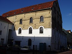 Watermill
.JPG)


Castles and stately homes in Valkenburg
[edit]-
 Ruined castle
 -
 Den Halder castle
 -
 Oost castle
 -
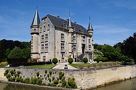 Schaloen castle


Tourist attractions in Valkenburg
[edit]-
 Grotestraat, Valkenburg mainstreet
 -
 Wilhelmina tower
 -
 Hotel built by Cuypers
 -
 Tourists queueing at Valkenburg castle
 -
 Roman catacombs (Cuypers)


.JPG)

.JPG)
Cycling
[edit]Valkenburg aan de Geul is famous for its cycling events. The city has hosted the UCI Road Cycling World Championship a record five times, in 1938, 1948, 1979 and 1998 and again in 2012. Since 2003, the city's Cauberg hill has been the finish of the Amstel Gold Race, and since 2017 is in the last 10km distance from the finish. The Tour de France had a stage finish in Valkenburg in 1992 and in 2006.
The Cauberg Cyclo-cross is a cyclo-cross race and a part of the UCI Cyclo-cross World Cup.
.jpg)
Population centres
[edit]Apart from the city of Valkenburg (including the neighbourhood of Broekhem), the municipality of Valkenburg aan de Geul comprises the following villages and hamlets: Berg en Terblijt, Vilt, Geulhem, Houthem, Sibbe, IJzeren, Oud-Valkenburg, Schin op Geul en Walem.
Transport
[edit]By car
[edit]Valkenburg aan de Geul is served by the A79 motorway, this motorway runs from Maastricht to Heerlen.
By train
[edit]Valkenburg aan de Geul has three train stations Valkenburg, Houthem-Sint Gerlach and Schin op Geul, operated by Arriva.
By bus
[edit]Valkenburg aan de Geul is served by Arriva buses
Notable residents
[edit]
- Saint Gerlach (died c. 1170), hermit
- Beatrice of Valkenburg (c. 1254 - 1277), queen of Germany
- Pierre Cuypers (1827 – 1921), architect; spent a few years in Valkenburg
- Erich Wasmann (1859 - 1931), Austrian-born entomologist
- Jan Hanlo (1912 - 1969), poet and writer, grew up in Valkenburg
- Raymond Barion (born 1946) a Dutch artist, made in the form of paintings, sculptures and on paper
- Gerlach Cerfontaine (born 1946), business leader, CEO of Schiphol Group
- Marjon Lambriks (born 1949), soprano
- Rob Delahaye (born 1959) a Dutch former professional footballer with 359 club caps
- Camiel Eurlings (born 1973), politician, business leader, corporate director for KLM
- Rob Ruijgh (born 1986), racing cyclist
Panorama
[edit]
References
[edit]- ^ "College van B&W" [Board of mayor and aldermen] (in Dutch). Gemeente Valkenburg aan de Geul. Retrieved 2 December 2013.
- ^ "Kerncijfers wijken en buurten 2020" [Key figures for neighbourhoods 2020]. StatLine (in Dutch). CBS. 24 July 2020. Retrieved 19 September 2020.
- ^ "Postcodetool for 6301HC". Actueel Hoogtebestand Nederland (in Dutch). Het Waterschapshuis. Retrieved 2 December 2013.
- ^ "Bevolkingsontwikkeling; regio per maand" [Population growth; regions per month]. CBS Statline (in Dutch). CBS. 1 January 2021. Retrieved 2 January 2022.
- ^ "De beelden van de wateroverlast in Zuid-Limburg". NRC (in Dutch). Retrieved 2021-07-18.
External links
[edit] Media related to Valkenburg aan de Geul at Wikimedia Commons
 Valkenburg aan de Geul travel guide from Wikivoyage
- Official website (in Dutch)
Places adjacent to Valkenburg aan de Geul | ||||||||||||||||
|---|---|---|---|---|---|---|---|---|---|---|---|---|---|---|---|---|
| ||||||||||||||||

| International | |
|---|---|
| National | |
| Geographic | |