
Jamaica–179th Street station: Difference between revisions
Epicgenius (talk | contribs) m fix per WP:USSTATION (via WP:JWB) |
Cards84664 (talk | contribs) Remove obsolete infobox parameters |
||
| (39 intermediate revisions by 18 users not shown) | |||
| Line 7: | Line 7: | ||
| image = 179th Street - Downtown Platform.jpg |
| image = 179th Street - Downtown Platform.jpg |
||
| image_caption = Manhattan-bound platform. An [[R160 (New York City Subway car)|R160]] [[F (New York City Subway service)|F]] train is visible on the Manhattan-bound local track. |
| image_caption = Manhattan-bound platform. An [[R160 (New York City Subway car)|R160]] [[F (New York City Subway service)|F]] train is visible on the Manhattan-bound local track. |
||
| ⚫ | |||
| bg_color = #FF6E1A|#0039A6 |
|||
| ⚫ | |||
| borough = [[Queens]] |
| borough = [[Queens]] |
||
| locale = [[Jamaica, Queens|Jamaica]], [[Jamaica Estates, Queens|Jamaica Estates]] |
| locale = [[Jamaica, Queens|Jamaica]], [[Jamaica Estates, Queens|Jamaica Estates]] |
||
| coordinates = {{coord|40.712459|N|73.78448|W|display=inline,title}} |
| coordinates = {{coord|40.712459|N|73.78448|W|display=inline,title}} |
||
| lat_dir = N |
|||
| lon_dir = W |
|||
| division = IND |
| division = IND |
||
| line = [[IND Queens Boulevard Line]] |
| line = [[IND Queens Boulevard Line]] |
||
| service = Queens Hillside |
| service = Queens Hillside |
||
| service_header = Queens Hillside header |
| service_header = Queens Hillside header |
||
| connection = {{Unbulleted list |
|||
| {{bus icon}} [[NYCT Bus]]: {{NYC bus link|Q1|Q2}}, [[Image:20 airtransportation.svg|12px|alt=Airport transportation]] {{NYC bus link|Q3|Q17|Q36|Q43|Q76|Q77|X68}} |
|||
| {{bus icon}} [[MTA Bus]]: {{NYC bus link|Q110}} |
|||
| {{bus icon}} [[NICE Bus]]: {{LI bus link|n1|n6|n6X|n22|n22X|n24|n26}} |
|||
}} |
|||
| platforms = 2 [[island platform]]s |
| platforms = 2 [[island platform]]s |
||
| tracks = 4 |
| tracks = 4 |
||
| structure = Underground |
| structure = Underground |
||
| open_date = {{start date and age|1950|December|11|p=y}}<ref name=NYTImes-179open-1950 /><ref>{{cite news|title=Subway Link Opens Monday|url=https://timesmachine.nytimes.com/timesmachine/1950/12/06/91121772.pdf|work=The New York Times|access-date=June 30, 2015|date=December 6, 1950}}</ref> |
| open_date = {{start date and age|1950|December|11|p=y}}<ref name=NYTImes-179open-1950 /><ref>{{cite news|title=Subway Link Opens Monday|url=https://timesmachine.nytimes.com/timesmachine/1950/12/06/91121772.pdf|work=The New York Times|access-date=June 30, 2015|date=December 6, 1950}}</ref> |
||
| adjacent_stations = {{Adjacent stations|system=New York City Subway |
|||
| passengers = 6,270,766<ref name="2016-rider">{{NYCS const|riderref}}</ref> |
|||
|line1=Queens express far east|left1=Parsons Boulevard|note-left1={{NYCS Queens far east express|time=1}} |
|||
| pass_year = 2018 |
|||
|line2=Queens local east|left2=169th Street|note-left2={{NYCS Queens far east local|time=1}}}} |
|||
| pass_percent = -3.0 |
|||
| rank = 67 |
|||
| code = 254 |
|||
| next_north = {{NYCS next|terminal=(Terminal)|service=Queens Hillside|time=show}} |
|||
| next_south = {{NYCS next | type=local | line=IND Queens Boulevard Line | station=169th Street | service=Queens Hillside local}}<br>{{NYCS next | type=express | line=IND Queens Boulevard Line | station=Parsons Boulevard | service=Queens Hillside express }} |
|||
| legend = {{NYCS infobox legend|alltimes}}{{NYCS infobox legend|rushonly}}{{NYCS infobox legend|limitedrushpeak}} |
| legend = {{NYCS infobox legend|alltimes}}{{NYCS infobox legend|rushonly}}{{NYCS infobox legend|limitedrushpeak}} |
||
| layout = {{Routemap|inline=y |
| layout = {{Routemap|inline=y |
||
|title=Track layout |
|title=Track layout |
||
|title-bg=#{{NYCS color|F}} |
|||
|title-color=white |
|||
|legend =track |
|legend =track |
||
|map-title=Upper level |
|map-title=Upper level |
||
| Line 47: | Line 42: | ||
udLSTR!~dMFADEg\uvÜST\udLSTR!~dMFADEg ~~ ~~ ~~ to lower level relay tracks |
udLSTR!~dMFADEg\uvÜST\udLSTR!~dMFADEg ~~ ~~ ~~ to lower level relay tracks |
||
uv-SHI2r\uvSTR\uvSHI2l- |
uv-SHI2r\uvSTR\uvSHI2l- |
||
udSTR\ |
udSTR\dPLT\uvSTR\dPLT\udSTR |
||
udSTR\ |
udSTR\dPLT\uvSTR\dPLT\udSTR |
||
udSTR\ |
udSTR\dPLT\uvSTR\dPLT\udSTR |
||
udSTR\ |
udSTR\dPLT\uvSTR\dPLT\udSTR |
||
uvSHI2l-\uvSTR\uv-SHI2r |
uvSHI2l-\uvSTR\uv-SHI2r |
||
uvSTRf\uvSTRg |
uvSTRf\uvSTRg |
||
udSTR!~dMFADEf\uvSTR\udSTR!~dMFADEf ~~ ~~ ~~ to |
udSTR!~dMFADEf\uvSTR\udSTR!~dMFADEf ~~ ~~ ~~ to {{stl|NYCS|169th Street|Queens}} |
||
uvSTR!~MFADEf ~~ ~~ ~~ to |
uvSTR!~MFADEf ~~ ~~ ~~ to {{stl|NYCS|Parsons Boulevard}} |
||
|map2-title=Lower level<br/>(east of station) |
|map2-title=Lower level<br/>(east of station) |
||
|map2= |
|map2= |
||
| Line 68: | Line 63: | ||
}} |
}} |
||
The '''Jamaica–179th Street station''' is an express [[terminal station]] on the [[IND Queens Boulevard Line]] of the [[New York City Subway]]. Located under Hillside Avenue at 179th Street in [[Jamaica, Queens]], it is served by the [[F (New York City Subway service)|F]] train at all times, the [[Fd (New York City Subway service)|<F>]] train during rush hours in the peak direction, and a few rush-hour [[E (New York City Subway service)|E]] trains. The station has 15 entrances, including two at Midland Parkway in [[Jamaica Estates, Queens|Jamaica Estates]]. |
The '''Jamaica–179th Street station''' is an express [[terminal station]] on the [[IND Queens Boulevard Line]] of the [[New York City Subway]]. Located under Hillside Avenue at 179th Street in [[Jamaica, Queens]], it is served by the [[F (New York City Subway service)|F]] train at all times, the [[Fd (New York City Subway service)|<F>]] train during rush hours in the reverse peak direction, and a few rush-hour [[E (New York City Subway service)|E]] trains. The station has 15 entrances, including two at Midland Parkway in [[Jamaica Estates, Queens|Jamaica Estates]]. |
||
Jamaica–179th Street was opened on December 11, 1950, although |
Jamaica–179th Street was opened on December 11, 1950, although a station had been planned at 178th Street as early as 1928. At the time, the Queens Boulevard Line was part of the [[Independent Subway System]] (IND), but the original IND plans did not provide for constructing the 178th Street station until the line was extended even further to [[Queens Village, Queens|Queens Village]]. The line opened to [[169th Street (IND Queens Boulevard Line)|169th Street]], the next station west, in 1937. Various changes in plans, as well as material shortages due to the [[Great Depression]] and [[World War II]], delayed the project until 1946. Jamaica–179th Street became among Queens' busiest upon its 1950 opening. After a period of deterioration, the station was renovated in the 1980s and again in the 2000s. As a result of planning for a never-built expansion to Queens Village, the station has eight storage tracks to its east, giving it the highest peak capacity of any New York City Subway station. |
||
==History== |
==History== |
||
The 179th Street station (drawn up as 178th Street) had been planned along with the rest of the [[IND Queens Boulevard Line]] as its original terminus as early as 1928.<ref name=NYTImes-QnsArteries-1928 /><ref name="LIDaily-QBLDigging-1933"> |
The 179th Street station (drawn up as 178th Street) had been planned along with the rest of the [[IND Queens Boulevard Line]] as its original terminus as early as 1928.<ref name="NYTImes-QnsArteries-1928">{{cite news |date=May 13, 1928 |title=Queens Interlaced With New Arteries: New Boulevards, Parks and Parkways Important Factors in Growth of Borough |work=The New York Times |url=https://query.nytimes.com/gst/abstract.html?res=9F0CEFD8103EE13ABC4B52DFB3668383639EDE |access-date=July 8, 2015}}</ref><ref name="LIDaily-QBLDigging-1933"> |
||
* {{cite news |ref=none|last1=Bland|first1=Maurice|title='Human Moles' Speed Digging Of Jamaica-Manhattan Subway;|url=http://fultonhistory.com/Newspaper%2014/Jamaica%20NY%20Long%20Island%20Daily%20Press/Jamaica%20NY%20Long%20Island%20Daily%20Press%201933/Jamaica%20NY%20Long%20Island%20Daily%20Press%201933%20-%201758.pdf#xml=http://fultonhistory.com/dtSearch/dtisapi6.dll?cmd=getpdfhits&u=5660b475&DocId=4804539&Index=Z%3a%5cIndex%20U%2dF%2dP&HitCount=8&hits=e+f+10+11+12+13+14+15+&SearchForm=%2fFulton%5fNew%5fform%2ehtml&.pdf|access-date=February 14, 2017|work=[[Long Island Daily Press]]|agency=[[Fultonhistory.com]]|date=1933}} |
* {{cite news |ref=none|last1=Bland|first1=Maurice|title='Human Moles' Speed Digging Of Jamaica-Manhattan Subway;|url=http://fultonhistory.com/Newspaper%2014/Jamaica%20NY%20Long%20Island%20Daily%20Press/Jamaica%20NY%20Long%20Island%20Daily%20Press%201933/Jamaica%20NY%20Long%20Island%20Daily%20Press%201933%20-%201758.pdf#xml=http://fultonhistory.com/dtSearch/dtisapi6.dll?cmd=getpdfhits&u=5660b475&DocId=4804539&Index=Z%3a%5cIndex%20U%2dF%2dP&HitCount=8&hits=e+f+10+11+12+13+14+15+&SearchForm=%2fFulton%5fNew%5fform%2ehtml&.pdf|access-date=February 14, 2017|work=[[Long Island Daily Press]]|agency=[[Fultonhistory.com]]|date=1933}} |
||
*{{cite news |ref=none|last1=Neufeld|first1=Ernest|title=Men Toil Under Earth to Build Subway|url=http://fultonhistory.com/Newspaper%2014/Jamaica%20NY%20Long%20Island%20Daily%20Press/Jamaica%20NY%20Long%20Island%20Daily%20Press%201936/Jamaica%20NY%20Long%20Island%20Daily%20Press%201936%20-%204852.pdf#xml=http://fultonhistory.com/dtSearch/dtisapi6.dll?cmd=getpdfhits&u=ffffffffb27da775&DocId=4830644&Index=Z%3a%5cIndex%20U%2dF%2dP&HitCount=7&hits=c+d+e+f+10+11+12+&SearchForm=%2fFulton%5fNew%5fform%2ehtml&.pdf|access-date=February 14, 2017|work=Long Island Daily Press|agency=[[Fultonhistory.com]]|date=August 23, 1936}}</ref><ref>{{cite news|title=Plans to be Drawn for 6th Av. Subway|url=https://timesmachine.nytimes.com/timesmachine/1935/04/01/94591834.pdf|work=The New York Times|access-date=June 30, 2015|date=April 1, 1935}}</ref><ref name="LIDaily-QBL178St-Jul1932"/> In December 1930,<ref name="LIDaily-QBL178St-Jul1932"/> however, it was planned to construct stations only up to [[169th Street (IND Queens Boulevard Line)|169th Street]], with tail tracks and switches installed up to the foot of the station at 178th Street, along with a provision for the station. The tracks ended at bumper blocks, and the tunnel at a bulkhead.<ref name="LIDaily-QBLDigging-1933"/><ref> |
*{{cite news |ref=none|last1=Neufeld|first1=Ernest|title=Men Toil Under Earth to Build Subway|url=http://fultonhistory.com/Newspaper%2014/Jamaica%20NY%20Long%20Island%20Daily%20Press/Jamaica%20NY%20Long%20Island%20Daily%20Press%201936/Jamaica%20NY%20Long%20Island%20Daily%20Press%201936%20-%204852.pdf#xml=http://fultonhistory.com/dtSearch/dtisapi6.dll?cmd=getpdfhits&u=ffffffffb27da775&DocId=4830644&Index=Z%3a%5cIndex%20U%2dF%2dP&HitCount=7&hits=c+d+e+f+10+11+12+&SearchForm=%2fFulton%5fNew%5fform%2ehtml&.pdf|access-date=February 14, 2017|work=Long Island Daily Press|agency=[[Fultonhistory.com]]|date=August 23, 1936}}</ref><ref>{{cite news|title=Plans to be Drawn for 6th Av. Subway|url=https://timesmachine.nytimes.com/timesmachine/1935/04/01/94591834.pdf|work=The New York Times|access-date=June 30, 2015|date=April 1, 1935}}</ref><ref name="LIDaily-QBL178St-Jul1932"/> In December 1930,<ref name="LIDaily-QBL178St-Jul1932"/> however, it was planned to construct stations only up to [[169th Street (IND Queens Boulevard Line)|169th Street]], with tail tracks and switches installed up to the foot of the station at 178th Street, along with a provision for the station. The tracks ended at bumper blocks, and the tunnel at a bulkhead.<ref name="LIDaily-QBLDigging-1933"/><ref> |
||
| Line 82: | Line 77: | ||
* {{cite news|title=Little Hope for Early Bus Franchise Action; Board of Estimate Meetings Are Curtailed|url=http://fultonhistory.com/Newspaper%2014/Jamaica%20NY%20Long%20Island%20Daily%20Press/Jamaica%20NY%20Long%20Island%20Daily%20Press%201936/Jamaica%20NY%20Long%20Island%20Daily%20Press%201936%20-%202620.pdf#xml=http://fultonhistory.com/dtSearch/dtisapi6.dll?cmd=getpdfhits&u=ffffffffd7894064&DocId=4828412&Index=Z%3a%5cIndex%20U%2dF%2dP&HitCount=21&hits=22+8b9+8bb+8bc+8be+939+93b+97d+97f+990+a0d+e03+e05+e0f+e17+e2a+126e+1270+1273+1621+1628+&SearchForm=%2fFulton%5fNew%5fform%2ehtml&.pdf|access-date=February 14, 2017|work=Long Island Daily Press|agency=[[Fultonhistory.com]]|date=May 21, 1936|page=1}} |
* {{cite news|title=Little Hope for Early Bus Franchise Action; Board of Estimate Meetings Are Curtailed|url=http://fultonhistory.com/Newspaper%2014/Jamaica%20NY%20Long%20Island%20Daily%20Press/Jamaica%20NY%20Long%20Island%20Daily%20Press%201936/Jamaica%20NY%20Long%20Island%20Daily%20Press%201936%20-%202620.pdf#xml=http://fultonhistory.com/dtSearch/dtisapi6.dll?cmd=getpdfhits&u=ffffffffd7894064&DocId=4828412&Index=Z%3a%5cIndex%20U%2dF%2dP&HitCount=21&hits=22+8b9+8bb+8bc+8be+939+93b+97d+97f+990+a0d+e03+e05+e0f+e17+e2a+126e+1270+1273+1621+1628+&SearchForm=%2fFulton%5fNew%5fform%2ehtml&.pdf|access-date=February 14, 2017|work=Long Island Daily Press|agency=[[Fultonhistory.com]]|date=May 21, 1936|page=1}} |
||
* {{cite news|title=Queens Is Surprised: Was Subway Secrecy Needed?|url=http://fultonhistory.com/Newspaper%2014/Jamaica%20NY%20Long%20Island%20Daily%20Press/Jamaica%20NY%20Long%20Island%20Daily%20Press%201938/Jamaica%20NY%20Long%20Island%20Daily%20Press%201938%20-%201625.pdf#xml=http://fultonhistory.com/dtSearch/dtisapi6.dll?cmd=getpdfhits&u=34b35cd3&DocId=4844028&Index=Z%3a%5cIndex%20U%2dF%2dP&HitCount=3&hits=83e+83f+840+&SearchForm=%2fFulton%5fNew%5fform%2ehtml&.pdf|access-date=February 14, 2017|work=Long Island Daily Press|agency=[[Fultonhistory.com]]|date=January 21, 1938|page=16}} |
* {{cite news|title=Queens Is Surprised: Was Subway Secrecy Needed?|url=http://fultonhistory.com/Newspaper%2014/Jamaica%20NY%20Long%20Island%20Daily%20Press/Jamaica%20NY%20Long%20Island%20Daily%20Press%201938/Jamaica%20NY%20Long%20Island%20Daily%20Press%201938%20-%201625.pdf#xml=http://fultonhistory.com/dtSearch/dtisapi6.dll?cmd=getpdfhits&u=34b35cd3&DocId=4844028&Index=Z%3a%5cIndex%20U%2dF%2dP&HitCount=3&hits=83e+83f+840+&SearchForm=%2fFulton%5fNew%5fform%2ehtml&.pdf|access-date=February 14, 2017|work=Long Island Daily Press|agency=[[Fultonhistory.com]]|date=January 21, 1938|page=16}} |
||
* {{cite news|title=Transit To Rockaways Dropped Back To Third Place In Program: "Financial Resources Are |
* {{cite news|title=Transit To Rockaways Dropped Back To Third Place In Program: "Financial Resources Are Inadequate", Delaney Tells Tugwell.|url=http://fultonhistory.com/Newspapers%2021/Rockaway%20Beach%20NY%20%20Wave%20Of%20Long%20Island/Rockaway%20Beach%20NY%20%20Wave%20Of%20Long%20Island%20%201939-1940/Rockaway%20Beach%20NY%20%20Wave%20Of%20Long%20Island%20%201939-1940%20-%200263.pdf#xml=http://fultonhistory.com/dtSearch/dtisapi6.dll?cmd=getpdfhits&u=ffffffffcf3fa240&DocId=9309207&Index=Z%3a%5cIndex%20I%2dE%2dV&HitCount=24&hits=1ae+2d5+596+748+8f2+cdd+1112+1113+1114+1115+1116+1118+1119+111b+11dc+122e+1235+1239+123a+127e+1375+1376+1378+1400+&SearchForm=%2fFulton%5fNew%5fform%2ehtml&.pdf|access-date=February 14, 2017|work=[[Wave of Long Island]]|agency=[[Fultonhistory.com]]|date=August 10, 1939|page=5}}</ref><ref name="LIDaily-SubwayWorkDelay-Aug1939">{{cite news|title=Subway Work Delayed By Lack of Funds: Jamaica Project, However, Still Tops the City's Official Plans|work=Long Island Daily Press|agency=[[Fultonhistory.com]]|date=August 11, 1939}}</ref><ref name="NYTimes-IND179Plan-Jul1946">{{cite news|title=Subway Plan Presented: Board of Estimate Gets Queens Extension Program|url=https://timesmachine.nytimes.com/timesmachine/1946/07/20/88373203.pdf|access-date=August 12, 2016|work=[[The New York Times]]|date=July 20, 1946}}</ref> Under the 1940 plans, construction of the station was set to take place between 1941 and 1945.<ref>{{cite news|last1=Hall|first1=Charles|title=New Schools and Subways Doomed in Budget Slash: Other Projects Also Set Back By Planners|url=http://fultonhistory.com/Newspaper%2014/Jamaica%20NY%20Long%20Island%20Daily%20Press/Jamaica%20NY%20Long%20Island%20Daily%20Press%201939/Jamaica%20NY%20Long%20Island%20Daily%20Press%201939%20-%204390.pdf#xml=http://fultonhistory.com/dtSearch/dtisapi6.dll?cmd=getpdfhits&u=ffffffffd582a6fd&DocId=4854330&Index=Z%3a%5cIndex%20U%2dF%2dP&HitCount=26&hits=20+1af+3e3+475+52f+530+532+533+602+7cf+7e1+87b+8d0+8e3+c83+cc5+cdf+d0c+d1d+d40+e1f+f49+1171+12eb+1301+1308+&SearchForm=%2fFulton%5fNew%5fform%2ehtml&.pdf|access-date=February 14, 2017|work=Long Island Daily Press|agency=[[Fultonhistory.com]]|date=November 2, 1939|page=1}}</ref> |
||
In January 1941, city councilman [[James A. Burke (New York politician)|James A. Burke]] proposed extending the line to 178th Street, in order to relieve congestion at 169th Street. Burke believed that a station could be built within the existing tunnel and trackage and cost only $100,000, while engineers from the Board of Transportation stated it would require additional tunneling and new relay tracks extending to 184th Street.<ref> |
|||
* {{cite news|title=Bus-Subway Muddle: Mr. Burke Has a Sensible Remedy|url=http://fultonhistory.com/Newspaper%2014/Jamaica%20NY%20Long%20Island%20Daily%20Press/Jamaica%20NY%20Long%20Island%20Daily%20Press%201941/Jamaica%20NY%20Long%20Island%20Daily%20Press%201941%20a%20-%200593.pdf#xml=http://fultonhistory.com/dtSearch/dtisapi6.dll?cmd=getpdfhits&u=4d31c4d5&DocId=4869530&Index=Z%3a%5cIndex%20U%2dF%2dP&HitCount=7&hits=b+9b+9c+9d+d02+1728+172f+&SearchForm=%2fFulton%5fNew%5fform%2ehtml&.pdf|access-date=February 14, 2017|work=Long Island Daily Press|agency=[[Fultonhistory.com]]|date=January 31, 1941|page=14}} |
* {{cite news|title=Bus-Subway Muddle: Mr. Burke Has a Sensible Remedy|url=http://fultonhistory.com/Newspaper%2014/Jamaica%20NY%20Long%20Island%20Daily%20Press/Jamaica%20NY%20Long%20Island%20Daily%20Press%201941/Jamaica%20NY%20Long%20Island%20Daily%20Press%201941%20a%20-%200593.pdf#xml=http://fultonhistory.com/dtSearch/dtisapi6.dll?cmd=getpdfhits&u=4d31c4d5&DocId=4869530&Index=Z%3a%5cIndex%20U%2dF%2dP&HitCount=7&hits=b+9b+9c+9d+d02+1728+172f+&SearchForm=%2fFulton%5fNew%5fform%2ehtml&.pdf|access-date=February 14, 2017|work=Long Island Daily Press|agency=[[Fultonhistory.com]]|date=January 31, 1941|page=14}} |
||
* {{cite news|title=178th Street Subway Plan To Take Years: Station to East Congestion Will Cost $2,000,000, Engineers Reveal|url=http://fultonhistory.com/Newspaper%2014/Jamaica%20NY%20Long%20Island%20Daily%20Press/Jamaica%20NY%20Long%20Island%20Daily%20Press%201941/Jamaica%20NY%20Long%20Island%20Daily%20Press%201941%20-%200731.pdf#xml=http://fultonhistory.com/dtSearch/dtisapi6.dll?cmd=getpdfhits&u=37b25dea&DocId=4863887&Index=Z%3a%5cIndex%20U%2dF%2dP&HitCount=46&hits=8c+121+19e+19f+1a0+1a1+1a4+30a+401+40f+413+416+417+44e+461+46b+47f+482+483+487+49e+4b8+4ba+4bb+4c5+4e7+4ec+50c+66e+6f5+703+708+716+760+981+99b+9c0+b04+cd7+d2d+ebb+fa7+111b+132f+1347+134e+&SearchForm=%2fFulton%5fNew%5fform%2ehtml&.pdf|access-date=February 14, 2017|work=Long Island Daily Press|agency=[[Fultonhistory.com]]|date=February 6, 1941|page=1}} |
* {{cite news|title=178th Street Subway Plan To Take Years: Station to East Congestion Will Cost $2,000,000, Engineers Reveal|url=http://fultonhistory.com/Newspaper%2014/Jamaica%20NY%20Long%20Island%20Daily%20Press/Jamaica%20NY%20Long%20Island%20Daily%20Press%201941/Jamaica%20NY%20Long%20Island%20Daily%20Press%201941%20-%200731.pdf#xml=http://fultonhistory.com/dtSearch/dtisapi6.dll?cmd=getpdfhits&u=37b25dea&DocId=4863887&Index=Z%3a%5cIndex%20U%2dF%2dP&HitCount=46&hits=8c+121+19e+19f+1a0+1a1+1a4+30a+401+40f+413+416+417+44e+461+46b+47f+482+483+487+49e+4b8+4ba+4bb+4c5+4e7+4ec+50c+66e+6f5+703+708+716+760+981+99b+9c0+b04+cd7+d2d+ebb+fa7+111b+132f+1347+134e+&SearchForm=%2fFulton%5fNew%5fform%2ehtml&.pdf|access-date=February 14, 2017|work=Long Island Daily Press|agency=[[Fultonhistory.com]]|date=February 6, 1941|page=1}} |
||
| Line 92: | Line 89: | ||
[[File:Weekend work 2012-09-04 24 (7929850270).jpg|thumb|left|250px|The western end of the lower relay yard; ramps can be seen going up to platform level]] |
[[File:Weekend work 2012-09-04 24 (7929850270).jpg|thumb|left|250px|The western end of the lower relay yard; ramps can be seen going up to platform level]] |
||
In 1981, the MTA listed the 179th Street station among the 69 most deteriorated stations in the subway system.<ref>{{cite news|last1=Gargan|first1=Edward A.|title=Agency Lists Its 69 Most Deteriorated Subway Stations|url=https://www.nytimes.com/1981/06/11/nyregion/agency-lists-its-69-most-deteriorated-subway-stations.html|access-date=August 13, 2016|work=The New York Times|date=June 11, 1981}}</ref> Later in the 1980s, the station was renovated and modernized; as part of the renovation, the IND-style purple tile band was removed from the station walls, and a design with intertwining blue and orange stripes was added.<ref name=NYTimes-NYCS-TroubledFuture-1984>{{cite web|last1=Farber|first1=M.A.|title=Transit System Is Facing A Troubled Future|url=https://www.nytimes.com/1984/08/01/nyregion/transit-system-is-facing-a-troubled-future.html?pagewanted=all|work=The New York Times|access-date=September 27, 2015|date=August 1, 1984}}</ref><ref>{{cite web|last1=Goldman|first1=Ari L.|title=M.T.A. Making Major Addition To Capital Plan|url=https://www.nytimes.com/1983/04/28/world/mta-making-major-addition-to-capital-plan.html|work=The New York Times|access-date=June 30, 2015|date=April 28, 1983}}</ref> |
In 1981, the MTA listed the 179th Street station among the 69 most deteriorated stations in the subway system.<ref>{{cite news|last1=Gargan|first1=Edward A.|title=Agency Lists Its 69 Most Deteriorated Subway Stations|url=https://www.nytimes.com/1981/06/11/nyregion/agency-lists-its-69-most-deteriorated-subway-stations.html|access-date=August 13, 2016|work=The New York Times|date=June 11, 1981}}</ref> Later in the 1980s, the station was renovated and modernized; as part of the renovation, the IND-style purple tile band was removed from the station walls, and a design with intertwining blue and orange stripes was added.<ref name=NYTimes-NYCS-TroubledFuture-1984>{{cite web|last1=Farber|first1=M.A.|title=Transit System Is Facing A Troubled Future|url=https://www.nytimes.com/1984/08/01/nyregion/transit-system-is-facing-a-troubled-future.html?pagewanted=all|work=The New York Times|access-date=September 27, 2015|date=August 1, 1984}}</ref><ref>{{cite web|last1=Goldman|first1=Ari L.|title=M.T.A. Making Major Addition To Capital Plan|url=https://www.nytimes.com/1983/04/28/world/mta-making-major-addition-to-capital-plan.html|work=The New York Times|access-date=June 30, 2015|date=April 28, 1983}}</ref> In 2002, the [[Metropolitan Transportation Authority]] announced that elevators would be installed at the 179th Street station.<ref>{{Cite magazine|url=https://erausa.org/pdf/bulletin/2000s/2002/2002-10-bulletin.pdf|date=October 2002|page=1|volume=45|issue=10|magazine=The Bulletin|title=NYC Transit's Goals for 2002|publisher=Electric Railroaders' Association}}</ref> Subsequently, elevators were installed in the station to make it [[ADA-accessible]].<ref name="Transalt-179" /><ref>{{cite news|last1=Sheridan|first1=Dick|title=Obstacle For Disabled Limited Access To Transport|url=http://www.nydailynews.com/archives/boroughs/obstacle-disabled-limited-access-transport-article-1.795986|access-date=August 13, 2016|work=New York Daily News|date=April 21, 1998}}</ref> The elevators were opened around 2005.<ref>{{cite news|author1=Diaz, Arnold|author-link=Arnold Díaz|title=Shame On You: NYC Transit Makes The Hall Of Shame|url=http://www.disabledinaction.org/news_20051020_wcbs.html|access-date=August 14, 2016|work=[[WCBS-TV]]|publisher=[[Disabled in Action]]|date=October 20, 2005|location=[[New York City|New York]]}}</ref> Starting in August 2007, the MTA began installing decorative ventilation grates along Hillside Avenue above the station, and sealing other grates, both in order to combat flooding. At the time, the Hillside Avenue subway was considered the most flood-prone area in the subway system.<ref>{{cite news|last1=Dunlap|first1=David W.|title=New Subway Grates Add Aesthetics to Flood Protection|url=https://cityroom.blogs.nytimes.com/2008/09/19/new-subway-grates-add-aesthetics-to-flood-protection/?module=ArrowsNav&contentCollection=N.Y.%2FRegion&action=keypress®ion=FixedLeft&pgtype=Blogs|access-date=February 14, 2017|work=[[The New York Times]]|date=September 19, 2008}}</ref> |
||
===Service history=== |
===Service history=== |
||
Initially, E trains served the station at all times, while F trains only operated to the station during late nights.<ref name=NYTImes-179open-1950 /><ref name="LIStar-IND179Open-Dec111950"/> In 1951, F trains were extended to 179th Street during the day as well.<ref>{{cite news|title=All 'F' Trains Will Run to 179 Street|work=Long Island Star-Journal|agency=[[Fultonhistory.com]]|date=October 4, 1951|page=1}}</ref> In 1953, the platforms at several IND stations were lengthened to allow eleven-car trains; originally, service was provided with ten-car trains.{{Efn|The platforms at {{stn|75th Avenue}} and {{stn|Sutphin Boulevard||IND Queens Boulevard Line}} on the Queens Boulevard Line were lengthened to allow 11-car operation on the E and F routes. The subway cars on the IND were built to be {{convert|60|feet|m|1}} long. These cars typically operated in 10-car trains, with an entire train length being {{convert|600|feet|m|1}}. When platforms at stations were lengthened to accommodate 11-car trains, the platforms had to be extended an additional car length, or {{convert|60|feet|m|1}}, making the platform at least {{convert|660|feet|m|1}} long.<ref>{{Cite book|url=https://books.google.com/books?id=6WFHNSXBpocC&q=60|title=New York Subways: An Illustrated History of New York City's Transit Cars|last=Sansone|first=Gene|date=October 25, 2004|publisher=JHU Press|isbn=9780801879227|language=en}}</ref>{{Rp|185}}}}<ref name="lengthened" /> The lengthened trains began running during rush hour on September 8, 1953. Eleven-car trains would only operate on weekdays.<ref>{{Cite book|url=https://books.google.com/books?id=XZDVAAAAMAAJ&q=%22the+lengthening%22|title=Report|date=1953|publisher=New York City Transit Authority|language=en}}</ref>{{rp|37–38}} The extra car increased the total carrying capacity by 4,000 passengers.<ref name="lengthened">{{Cite news|url=https://timesmachine.nytimes.com/timesmachine/1953/08/28/83735052.pdf|title=2 Subway Lines to Add Cars, Another to Speed Up Service|last=Ingalls|first=Leonard|date=August 28, 1953|work=The New York Times|access-date=January 25, 2016|issn=0362-4331}}</ref> The operation of eleven-car trains ended in 1958 because of operational difficulties. The signal blocks, especially in Manhattan, were too short to accommodate the longer trains, and the motormen had a very small margin of error to properly platform the train. It was found that operating ten-car trains allowed for two additional trains per hour to be scheduled.<ref>{{Cite news|url=http://fultonhistory.com/highlighter/highlight-for-xml?altUrl=http%3A%2F%2Ffultonhistory.com%2FNewspaper%252014%2FLong%2520Island%2520City%2520NY%2520Star%2520Journal%2FLong%2520Island%2520City%2520NY%2520Star%2520Journal%25201962%2FLong%2520Island%2520City%2520NY%2520Star%2520Journal%25201962%2520-%25207607.pdf%23xml%3Dhttp%3A%2F%2Ffultonhistory.com%2FdtSearch%2Fdtisapi6.dll%3Fcmd%3Dgetpdfhits%26u%3Dfdc6273%26DocId%3D4233713%26Index%3DZ%253a%255cIndex%2520U%252dF%252dP%26HitCount%3D16%26hits%3D52%2Bc3%2B1ce%2B1de%2B203%2B24a%2B253%2B259%2B26a%2B270%2B278%2B287%2B299%2B2b3%2B2bc%2B2bd%2B%26SearchForm%3D%252fFulton%255fform%252ehtml%26.pdf&uri=http%3A%2F%2Ffultonhistory.com%2FNewspaper%252014%2FLong%2520Island%2520City%2520NY%2520Star%2520Journal%2FLong%2520Island%2520City%2520NY%2520Star%2520Journal%25201962%2FLong%2520Island%2520City%2520NY%2520Star%2520Journal%25201962%2520-%25207607.pdf&xml=http%3A%2F%2Ffultonhistory.com%2FdtSearch%2Fdtisapi6.dll%3Fcmd%3Dgetpdfhits%26u%3Dfdc6273%26DocId%3D4233713%26Index%3DZ%253a%255cIndex%2520U%252dF%252dP%26HitCount%3D16%26hits%3D52%2Bc3%2B1ce%2B1de%2B203%2B24a%2B253%2B259%2B26a%2B270%2B278%2B287%2B299%2B2b3%2B2bc%2B2bd%2B%26SearchForm%3D%252fFulton%255fform%252ehtml%26.pdf&openFirstHlPage=false|title=16-Point Plan Can Give Boro Relief Now|date=August 10, 1962|work=Long Island Star–Journal|access-date=April 24, 2018}}</ref> |
|||
Initially, E trains served the station at all times, while F trains only operated to the station during late nights.<ref name=NYTImes-179open-1950 /><ref name="LIStar-IND179Open-Dec111950"/> In 1951, F trains were extended to 179th Street during the day as well.<ref>{{cite news|title=All 'F' Trains Will Run to 179 Street|work=Long Island Star-Journal|agency=[[Fultonhistory.com]]|date=October 4, 1951|page=1}}</ref> |
|||
179th Street served as the full-time northern terminal for both Queens Boulevard express services (the E and F trains), which led to congestion at the station,<ref name=NYTimes-NYCS-BigChanges-1988>{{cite news|last1=Johnson|first1=Kirk|title=Big Changes For Subways Are to Begin|url=https://www.nytimes.com/1988/12/09/nyregion/big-changes-for-subways-are-to-begin.html?pagewanted=all|work=The New York Times|access-date=July 14, 2015|date=December 9, 1988}}</ref> until December 11, 1988, when the E was rerouted to the [[Archer Avenue Lines|Archer Avenue Subway]].<ref name=NYTimes-NYCS-BigChanges-1988/> The [[R (New York City Subway service)|R]] served the station from 1988 to 1992, but only provided rush-hour service after 1990.<ref name=MTA-ServiceChanges-Sept1990>{{cite web|title=Service Changes: September 30, 1990|url=http://www.subwaynut.com/brochures/1990servicechanges.pdf|publisher=Metropolitan Transportation Authority|access-date=August 9, 2015|date=September 30, 1990}}</ref> |
179th Street served as the full-time northern terminal for both Queens Boulevard express services (the E and F trains), which led to congestion at the station,<ref name=NYTimes-NYCS-BigChanges-1988>{{cite news|last1=Johnson|first1=Kirk|title=Big Changes For Subways Are to Begin|url=https://www.nytimes.com/1988/12/09/nyregion/big-changes-for-subways-are-to-begin.html?pagewanted=all|work=The New York Times|access-date=July 14, 2015|date=December 9, 1988}}</ref> until December 11, 1988, when the E was rerouted to the [[Archer Avenue Lines|Archer Avenue Subway]].<ref name=NYTimes-NYCS-BigChanges-1988/> The [[R (New York City Subway service)|R]] served the station from 1988 to 1992, but only provided rush-hour service after 1990. [[G (New York City Subway service)|G]] trains also served this station during late nights from 1990 to 1997 as a replacement for the [[R (New York City Subway service)|R]] as it was cut back to [[36th Street (BMT Fourth Avenue Line)|36th Street]].<ref name=MTA-ServiceChanges-Sept1990>{{cite web|title=Service Changes: September 30, 1990|url=http://www.subwaynut.com/brochures/1990servicechanges.pdf|publisher=Metropolitan Transportation Authority|access-date=August 9, 2015|date=September 30, 1990|archive-date=October 26, 2014|archive-url=https://web.archive.org/web/20141026015324/http://www.subwaynut.com/brochures/1990servicechanges.pdf|url-status=dead}}</ref> Late night [[G (New York City Subway service)|G]] service to this station was replaced by [[F (New York City Subway service)|F]] trains on August 30, 1997.<ref>{{Cite news|url=https://www.newspapers.com/clip/24160214/august_30_queens_boulevard_changes/|title=Starting August 30, there will be changes in late-night service along Queens Boulevard.|date=September 2, 1997|work=New York Daily News|access-date=September 30, 2018}}</ref> |
||
| ⚫ | |||
Starting in 2001, selected rush-hour E trains began running to 179th Street, making express stops along Hillside Avenue, due to capacity constraints at [[Jamaica Center–Parsons/Archer station|Jamaica Center]].<ref name=":3">{{Cite journal |last=Linder |first=Bernard |date=December 2010 |title=E Service Changes |url=https://erausa.org/pdf/bulletin/2010/2010-12-bulletin.pdf |journal=The Bulletin |publisher=Electric Railroaders' Association |volume=53 |issue=12 |pages=2–3}}</ref><ref>{{Cite book |url=https://www.flickr.com/photos/127872292@N06/46995921035/in/album-72157708728211704/ |title=63rd Street Connection Operating Guide |publisher=New York City Transit |year=2001 |pages=I–1}}</ref> Starting on August 28, 2023, and continuing through the first quarter of 2024, E service to 179th Street was temporarily suspended.<ref>{{Cite web |title=Service changes on the F and M lines starting August 28 |url=https://new.mta.info/article/service-changes-f-and-m-lines-starting-august-28 |access-date=July 30, 2023 |website=MTA |language=en}}</ref><!-- |
|||
| ⚫ | The station sees a total of 14 rush hour trains on weekdays; four originating and three terminating at this station during the a.m. rush, and three originating and four terminating at the station during the p.m. rush.<ref>{{cite web | title=E train southbound | website=Trip Planner+ | url=http://tripplanner.mta.info/MyTrip/ui_web/serviceinthearea/Timetable.aspx?operator=SUB&route=E&inputDate=11/07/16&direction=S&type=E | access-date=October 30, 2016}}</ref><ref>{{cite web | title=E train northbound | website=Trip Planner+ | url=http://tripplanner.mta.info/MyTrip/ui_web/serviceinthearea/Timetable.aspx?operator=SUB&route=E&inputDate=11/07/16&direction=N&type=E | access-date=October 30, 2016}}</ref> |
||
--> |
|||
==Station layout== |
==Station layout== |
||
{| border=0 cellspacing=0 cellpadding=3 |
|||
{{NYCS Platform Layout IND Queens Boulevard Line/179th Street}} |
|||
|style="border-top:solid 1px gray;" width=50|'''Ground''' |
|||
|style="border-top:solid 1px gray;" width=100|Street level |
|||
|style="border-top:solid 1px gray;" width=500|Exit/entrance |
|||
|- |
|||
|style="border-top:solid 1px gray;" colspan=2|'''Mezzanine''' |
|||
|style="border-top:solid 1px gray;"|Fare control, station agent<br>{{NYCS Platform Layout access}} |
|||
|- |
|||
|style="border-top:solid 1px gray;border-bottom:solid 1px gray;vertical-align:top;" rowspan=6|'''Platform<br/>level''' |
|||
|style="border-top:solid 1px gray;"|Track '''1''' |
|||
|style="border-top:solid 1px gray;"|← {{rint|newyork|F}} {{rint|newyork|Fd}} toward {{stl|NYCS|Coney Island–Stillwell Avenue}} <small>({{stl|NYCS|169th Street}})</small><br>← {{rint|newyork|E}} toward {{stl|NYCS|World Trade Center}} (select weekday trips) <small>({{stl|NYCS|Parsons Boulevard}})</small> |
|||
|- |
|||
|style="border-top:solid 2px black;border-right:solid 2px black;border-left:solid 2px black;border-bottom:solid 2px black;text-align:center;" colspan=2|<small>[[Island platform]] {{access icon}}</small> |
|||
|- |
|||
|style="border-bottom:solid 1px gray;"|Track '''3''' |
|||
|style="border-bottom:solid 1px gray;"|← {{rint|newyork|F}}{{rint|newyork|Fd}} toward Coney Island–Stillwell Avenue <small>(169th Street)</small><br>← {{rint|newyork|E}} toward World Trade Center (select weekday trips) <small>(Parsons Boulevard)</small> |
|||
|- |
|||
|Track '''4''' |
|||
|{{0|→}} {{rint|newyork|F}}{{rint|newyork|Fd}} termination track →<br>{{0|→}} {{rint|newyork|E}} termination track (select weekday trips) → |
|||
|- |
|||
|style="border-top:solid 2px black;border-right:solid 2px black;border-left:solid 2px black;border-bottom:solid 2px black;text-align:center;" colspan=2|<small>[[Island platform]] {{access icon}}</small> |
|||
|- |
|||
|style="border-bottom:solid 1px gray;"|Track '''2''' |
|||
|style="border-bottom:solid 1px gray;"|{{0|→}} {{rint|newyork|F}}{{rint|newyork|Fd}} termination track →<br>{{0|→}} {{rint|newyork|E}} termination track (select weekday trips) → |
|||
|} |
|||
{{Multiple image |
{{Multiple image |
||
|align=left |
|align=left |
||
| Line 112: | Line 136: | ||
|caption2=View across the platform showing the intertwined wall design |
|caption2=View across the platform showing the intertwined wall design |
||
}} |
}} |
||
This underground station is identical to a typical express station, with four tracks and two [[island platform]]s.<ref name="NYCDCP-JamaicaPlan-Ch17"/> F trains serve the station at all times,<ref name="NYCS const|timetable|f">{{NYCS const|timetable|f}}</ref> and infrequent rush hour E trains also serve the station.<ref>{{NYCS const|timetable|e}}</ref> The station is the [[Railroad directions|railroad north]] terminus of all service.<ref name="submap2">{{NYCS const|map}}</ref> To the west (railroad south), the next stop is [[169th Street station (IND Queens Boulevard Line)|169th Street]] for local trains and [[Parsons Boulevard station|Parsons Boulevard]] for express trains.<ref name="tracks">{{NYCS const|trackref|trackbook3}}</ref> |
|||
| ⚫ | |||
* {{NYCS const|timetable|e}} |
|||
| ⚫ | * |
||
| ⚫ | To the east is a large storage and relay yard consisting of two levels with four relay tracks each,<ref name="QBL-HillsideExt-1931" /> extending approximately {{convert|.25|mi|km}}<ref>{{cite web|last1=Verhovek|first1=Sam Howe|title=For Shelter, Homeless Take the E Train|url=https://www.nytimes.com/1988/11/21/nyregion/for-shelter-homeless-take-the-e-train.html?pagewanted=all|work=[[The New York Times]]|access-date=July 15, 2015|date=November 21, 1988}}</ref> to around 184th Place.{{efn|Some sources state that the relay tracks end at 184th Street.<ref name="LIStar-179ExtDec11950"/> Others state that the tracks extend to 184th Place/185th Street or 186th Street.<ref name="NYTimes-IND179Plan-Jul1946"/><ref name="BOT-1949">{{Cite book|title=Report for the three and one-half years ending June 30, 1949.|publisher=New York City Board of Transportation|date=1949|hdl = 2027/mdp.39015023094926}}</ref><ref name=NYTImes-179StRoute-1946 /><ref name="LIStar-QBL-Phantom-Jan1959">{{cite news|last1=Marks|first1=Seymour|url=http://fultonhistory.com/Newspaper%2014/Long%20Island%20City%20NY%20Star%20Journal/Long%20Island%20City%20NY%20Star%20Journal%201959/Long%20Island%20City%20NY%20Star%20Journal%201959%20-%200631.pdf|title=Phantom Subway: Ideal Spot to Park|date=January 20, 1959|work=Long Island Star-Journal|access-date=August 12, 2016|url-status=live|archive-url=https://web.archive.org/web/20200325092047/https://fultonhistory.com/Newspaper%2014/Long%20Island%20City%20NY%20Star%20Journal/Long%20Island%20City%20NY%20Star%20Journal%201959/Long%20Island%20City%20NY%20Star%20Journal%201959%20-%200631.pdf|archive-date=March 25, 2020|page=3}}</ref>}}<ref name="QBL-HillsideExt-1931" /><ref>{{Cite book|url=https://books.google.com/books?id=UrocAQAAMAAJ&q=%22fulton+street+extension%22|title=Proceedings ...|last=Transportation|first=New York (N. Y. ) Board of|date=1949|language=en}}</ref>{{Rp|923, 1597}} This total of eight storage tracks gives 179th Street the highest peak terminal capacity of any station in the New York City Subway: 63 trains per hour, or one train every 57 seconds, although the station currently operates at a far lower throughput (only 17–18 trains per hour during peak hours).{{efn|A maximum of 14 to 15 F trains per hour operate from the station during peak hours, while three E trains per hour depart or arrive at the station during peak hours only.<ref name="ScheduleCurrent"/> Under MTA standards, the station could facilitate up to 15 trains per hour from two full-time services, a total of 30 trains per hour.<ref name="QnsOptionsStudyEIS-1990"/><ref name=QueensSubwayEIS-1984>{{cite book|title=Queens Subway Options Study, New York: Environmental Impact Statement|url=https://books.google.com/books?id=NaI4AQAAMAAJ&pg=PA83|access-date=July 10, 2016|date=May 1984|publisher=[[United States Department of Transportation]], [[Metropolitan Transportation Authority]], [[Urban Mass Transit Administration]]|pages=83–}}</ref>}}<ref name="ScheduleCurrent">*{{NYCS const|timetable|e}} |
||
| ⚫ | |||
| ⚫ | *{{NYCS const|timetable|f}}</ref><ref name="QnsOptionsStudyEIS-1990">{{cite book|title=Alternatives Analysis/Supplemental Draft Environmental Impact Statement for the Queens Subway Options Study|url=https://books.google.com/books?id=ed43AQAAMAAJ&pg=SA3-PA6|access-date=August 13, 2016|date=May 1990|publisher=[[United States Department of Transportation]], [[Metropolitan Transportation Authority]], [[Urban Mass Transit Administration]]}}</ref> Terminating trains enter on one of the two northbound tracks, then relay to one of the two levels—the upper level if coming from the express track, or the lower level if coming from the local track.<ref name="QBL-HillsideExt-1931">{{cite web|title=Hillside Avenue Extension, Route 108-Section 13|url=http://www.vanshnookenraggen.com/_index/wp-content/uploads/2015/05/IND_Hillside-Ext.jpg|access-date=July 10, 2016}}</ref> They then return on the corresponding track on the southbound side.<ref name="tracks" /> Southbound trains may leave from either the local or express tracks, although F trains departing from the express track switch to the local track east of [[169th Street (IND Queens Boulevard Line)|169th Street]].<ref name="tracks" /> Outside of relay operations, the yard provides storage for four trains.<ref name="BOT-1949" /> It is estimated that the relay tracks east of the station can fit about 600 passenger automobiles.<ref name="LIStar-QBL-Phantom-Jan1959" /> |
||
The station has beige wall tiles with intertwining blue and orange stripes, representing the two colors of the [[New York City]] flag, and the colors of the [[IND Eighth Avenue Line|IND Eighth Avenue]] and [[IND Sixth Avenue Line|Sixth Avenue]] lines which serve the station.<ref>{{cite news|title=The art of styling the subways: Slow down and look around|url=http://www.newsday.com/news/new-york/the-art-of-styling-the-subways-slow-down-and-look-around-1.2252334|access-date=August 12, 2016|work=[[Newsday]]}}</ref> There are two [[fare control]] areas. The full-time area at the east end of the station, between 179th and 180th Streets, has a token booth and a bank of 12 turnstiles and two high-exit-only turnstiles.<ref name="NYCDCP-JamaicaPlan-Ch17"/> The part-time exit at 178th Street contains a nine-turnstile bank, two high exit entrance turnstiles (HEETs), and two high exit turnstiles.<ref name="NYCDCP-JamaicaPlan-Ch17"/> The two ends are connected by a full-length [[mezzanine (architecture)|mezzanine]],<ref name="NYCDCP-JamaicaPlan-Ch17"/><ref name="LIStar-QBL-Phantom-Jan1959" /> which features ''Our Spectrum of Support'' artwork by Reginald Polynice, a set of plywood cutout figures appearing to hold up the ceiling of the mezzanine.<ref>{{Cite web|url=http://www.nycsubway.org/wiki/Artwork:_Our_Spectrum_of_Support_(Reginald_Polynice)|title=www.nycsubway.org: Artwork: Our Spectrum of Support (Reginald Polynice)|website=www.nycsubway.org|access-date=August 14, 2016}}</ref> The station also features a control tower.<ref name=NYTImes-179open-1950 /> The station is [[Americans with Disabilities Act of 1990|ADA-accessible]] via an elevator installed at 179th Place on the north side of Hillside Avenue.<ref name="Transalt-179">{{cite web|url=http://www.transalt.org/sites/default/files/resources/otherreports/subwaysidewalk/techmemo3/Queens/179th%20Street.pdf|title=Subway-Sidewalk Interface Project: 179th Street Station|date=December 30, 2000|website=[[Transportation Alternatives|transalt.org]]|publisher=[[Transportation Alternatives]], [[New York City|City of New York]], [[New York City Department of City Planning]], [[New York City Department of Transportation]]|access-date=June 30, 2015}}</ref><ref name="MTAJamaicaMap-2015">{{cite web|url=https://new.mta.info/sites/default/files/2018-04/Jamaica%20179%20St%20%28F%29%20web.pdf|title=Jamaica-179th Street Neighborhood Map|date=April 2018|website=mta.info|publisher=Metropolitan Transportation Authority|access-date=August 26, 2019}}</ref> |
The station has beige wall tiles with intertwining blue and orange stripes, representing the two colors of the [[New York City]] flag, and the colors of the [[IND Eighth Avenue Line|IND Eighth Avenue]] and [[IND Sixth Avenue Line|Sixth Avenue]] lines which serve the station.<ref>{{cite news|title=The art of styling the subways: Slow down and look around|url=http://www.newsday.com/news/new-york/the-art-of-styling-the-subways-slow-down-and-look-around-1.2252334|access-date=August 12, 2016|work=[[Newsday]]}}</ref> There are two [[fare control]] areas. The full-time area at the east end of the station, between 179th and 180th Streets, has a token booth and a bank of 12 turnstiles and two high-exit-only turnstiles.<ref name="NYCDCP-JamaicaPlan-Ch17"/> The part-time exit at 178th Street contains a nine-turnstile bank, two high exit entrance turnstiles (HEETs), and two high exit turnstiles.<ref name="NYCDCP-JamaicaPlan-Ch17"/> The two ends are connected by a full-length [[mezzanine (architecture)|mezzanine]],<ref name="NYCDCP-JamaicaPlan-Ch17"/><ref name="LIStar-QBL-Phantom-Jan1959" /> which features ''Our Spectrum of Support'' artwork by Reginald Polynice, a set of plywood cutout figures appearing to hold up the ceiling of the mezzanine.<ref>{{Cite web|url=http://www.nycsubway.org/wiki/Artwork:_Our_Spectrum_of_Support_(Reginald_Polynice)|title=www.nycsubway.org: Artwork: Our Spectrum of Support (Reginald Polynice)|website=www.nycsubway.org|access-date=August 14, 2016}}</ref> The station also features a control tower.<ref name=NYTImes-179open-1950 /> The station is [[Americans with Disabilities Act of 1990|ADA-accessible]] via an elevator installed at 179th Place on the north side of Hillside Avenue.<ref name="Transalt-179">{{cite web|url=http://www.transalt.org/sites/default/files/resources/otherreports/subwaysidewalk/techmemo3/Queens/179th%20Street.pdf|title=Subway-Sidewalk Interface Project: 179th Street Station|date=December 30, 2000|website=[[Transportation Alternatives|transalt.org]]|publisher=[[Transportation Alternatives]], [[New York City|City of New York]], [[New York City Department of City Planning]], [[New York City Department of Transportation]]|access-date=June 30, 2015}}</ref><ref name="MTAJamaicaMap-2015">{{cite web|url=https://new.mta.info/sites/default/files/2018-04/Jamaica%20179%20St%20%28F%29%20web.pdf|title=Jamaica-179th Street Neighborhood Map|date=April 2018|website=mta.info|publisher=Metropolitan Transportation Authority|access-date=August 26, 2019}}</ref> |
||
The station lies about {{convert|3.25|mi}} west of the city's border with [[Nassau County, New York|Nassau County]]. Until the [[IND Rockaway Line]] was opened in 1956,<ref name="NYTimes-INDRkwyOpen-1956">{{cite news|url=https://timesmachine.nytimes.com/timesmachine/1956/06/28/84703811.pdf|title=Rockaway Trains to Operate Today|last1=Freeman|first1=Ira Henry|date=June 28, 1956|work=The New York Times|issn=0362-4331|access-date=June 29, 2015}}</ref> and until the 1958 opening of the line's [[Far Rockaway–Mott Avenue (IND Rockaway Line)|Far Rockaway–Mott Avenue terminal]] (which is about {{convert|0.5|mi|km}} from the city's border with Nassau County<ref>{{Google maps|url=https://www.google.com/maps/place/Nassau+County,+NY/@40.6082405,-73.760384,13.97z/data=!4m5!3m4!1s0x89c2b19dcb5e0ca1:0x1b248a99d3069e6a!8m2!3d40.6546145!4d-73.5594128!5m1!1e2|title=Nassau County, NY|access-date=August 15, 2016}}</ref>), 179th Street was the closest subway station to Nassau County.<ref name="NYTImes-FarRkwyIND-Open-1958">{{cite news|url=https://timesmachine.nytimes.com/timesmachine/1958/01/16/83388071.pdf|title=New Subway Unit Ready: Far Rockaway IND Terminal Will Be Opened Today|date=January 16, 1958|work=The New York Times|issn=0362-4331|access-date=June 29, 2015}}</ref> ''[[New York (magazine)|New York Magazine]]'' described the station's location as being in "a neighborhood so outer-borough it might as well be in another state"—namely, one of "hip-hop’s fertile crescents" where rappers [[50 Cent]] and [[Ja Rule]] grew up.<ref>{{Cite web|url=http://nymag.com/nymetro/news/features/n_9562/|title=Got Beef?|last=Brown|first=Ethan|date=December 1, 2003|website=New York Magazine|page=1|access-date=February 15, 2017}}</ref> |
The station lies about {{convert|3.25|mi}} west of the city's border with [[Nassau County, New York|Nassau County]]. Until the [[IND Rockaway Line]] was opened in 1956,<ref name="NYTimes-INDRkwyOpen-1956">{{cite news|url=https://timesmachine.nytimes.com/timesmachine/1956/06/28/84703811.pdf|title=Rockaway Trains to Operate Today|last1=Freeman|first1=Ira Henry|date=June 28, 1956|work=The New York Times|issn=0362-4331|access-date=June 29, 2015}}</ref> and until the 1958 opening of the line's [[Far Rockaway–Mott Avenue (IND Rockaway Line)|Far Rockaway–Mott Avenue terminal]] (which is about {{convert|0.5|mi|km}} from the city's border with Nassau County<ref>{{Google maps|url=https://www.google.com/maps/place/Nassau+County,+NY/@40.6082405,-73.760384,13.97z/data=!4m5!3m4!1s0x89c2b19dcb5e0ca1:0x1b248a99d3069e6a!8m2!3d40.6546145!4d-73.5594128!5m1!1e2|title=Nassau County, NY|access-date=August 15, 2016}}</ref>), 179th Street was the closest subway station to Nassau County.<ref name="NYTImes-FarRkwyIND-Open-1958">{{cite news|url=https://timesmachine.nytimes.com/timesmachine/1958/01/16/83388071.pdf|title=New Subway Unit Ready: Far Rockaway IND Terminal Will Be Opened Today|date=January 16, 1958|work=The New York Times|issn=0362-4331|access-date=June 29, 2015}}</ref> ''[[New York (magazine)|New York Magazine]]'' described the station's location as being in "a neighborhood so outer-borough it might as well be in another state"—namely, one of "hip-hop’s fertile crescents" where rappers [[50 Cent]] and [[Ja Rule]] grew up.<ref>{{Cite web|url=http://nymag.com/nymetro/news/features/n_9562/|title=Got Beef?|last=Brown|first=Ethan|date=December 1, 2003|website=New York Magazine|page=1|access-date=February 15, 2017}}</ref> |
||
=== Extension provisions === |
|||
| ⚫ | The configuration of the relay tracks is evidence of the original plans to build an extension of the Queens Boulevard Line further east into Queens. The line would have continued under Hillside Avenue to [[Springfield Boulevard]] and [[New York State Route 25|Braddock Avenue]] (both formerly Rocky Hill Road) in [[Queens Village, Queens|Queens Village]],<ref name="NYTImes-QnsArteries-1928" /><ref name="LIDaily-SubwayWorkDelay-Aug1939" /> with later plans to extend the line to [[Little Neck Parkway]] in [[Bellerose, Queens|Bellerose]] near the [[Nassau County, New York|Nassau County]] border.<ref name="WheelsDroveNY-2012">{{cite book |author1=Roger P. Roess |url=https://books.google.com/books?id=qfZ0VxuLoc0C&pg=PA416 |title=The Wheels That Drove New York: A History of the New York City Transit System |author2=Gene Sansone |date=August 23, 2012 |publisher=Springer Science & Business Media |isbn=978-3-642-30484-2 |pages=416–}}</ref> The upper level was to be extended eastward while the lower level tracks were always intended to be relay tracks.<ref name="QBL-HillsideExt-1931" /><ref name=":1">{{Cite web |date=September 23, 2015 |title=Mysteries of the Queens Boulevard Subway |url=http://www.vanshnookenraggen.com/_index/2015/09/mysteries-of-the-queens-boulevard-subway/ |access-date=July 10, 2016 |language=en-US}}</ref> The tracks on the upper level are longer than the lower level tracks and the upper level tracks have a wooden partition at the [[bumper block]]s.<ref name="QBL-HillsideExt-1931" /><ref name=":1" /> |
||
===Entrances and exits=== |
===Entrances and exits=== |
||
| Line 127: | Line 153: | ||
| direction = vertical |
| direction = vertical |
||
| width = 225 |
| width = 225 |
||
| caption_align = <!-- left (default), center, right --> |
| caption_align = <!-- left (default), center, right --> |
||
<!--image 1--> |
<!--image 1--> |
||
| image1 = 179th Street - Northside Stairs.jpg |
| image1 = 179th Street - Northside Stairs.jpg |
||
| Line 144: | Line 170: | ||
| caption3 = Elevator at 179th Place |
| caption3 = Elevator at 179th Place |
||
| footer = |
|||
}} |
}} |
||
The station has a total of 15 staircase entrances and 1 elevator entrance.<ref name=Transalt-179 /><ref name="NYCDCP-JamaicaPlan-Ch17">{{cite web|url=http://www1.nyc.gov/assets/planning/download/pdf/applicants/env-review/jamaica/17_feis.pdf#page=5|title=The Jamaica Plan - Final Environmental Impact Statement; Chapter 17 – Transit and Pedestrians|website=nyc.gov|publisher=New York City Department of City Planning|access-date=August 14, 2016}}</ref><ref name=MTAJamaicaMap-2015/> There are seven full-time entrances at four locations (consisting of six stairs and one elevator), which are indicated in green, and nine other part-time entrances, which are indicated in red.<ref name=Transalt-179 /> |
The station has a total of 15 staircase entrances and 1 elevator entrance.<ref name=Transalt-179 /><ref name="NYCDCP-JamaicaPlan-Ch17">{{cite web|url=http://www1.nyc.gov/assets/planning/download/pdf/applicants/env-review/jamaica/17_feis.pdf#page=5|title=The Jamaica Plan - Final Environmental Impact Statement; Chapter 17 – Transit and Pedestrians|website=nyc.gov|publisher=New York City Department of City Planning|access-date=August 14, 2016}}</ref><ref name=MTAJamaicaMap-2015/> There are seven full-time entrances at four locations (consisting of six stairs and one elevator), which are indicated in green, and nine other part-time entrances, which are indicated in red.<ref name=Transalt-179 /> |
||
| Line 202: | Line 228: | ||
=== Nearby points of interest === |
=== Nearby points of interest === |
||
The childhood home of former |
The childhood home of former president [[Donald Trump]], located at [[85-15 Wareham Place]], is a few blocks away from the Midland Parkway entrance to the station. Trump's father [[Fred Trump]] built the house a year after the station opened, in 1951.<ref>{{Cite news|url=https://www.nytimes.com/2015/09/23/us/politics/donald-trumps-old-queens-neighborhood-now-a-melting-pot-was-seen-as-a-cloister.html|title=Donald Trump's Old Queens Neighborhood Contrasts With the Diverse Area Around It|last=Horowitz|first=Jason|date=September 22, 2015|newspaper=The New York Times|access-date=February 15, 2017|issn=0362-4331}}</ref> |
||
A mosaic sign within one of the station's exits points to the "Monastery and Retreat House". This refers to the [[Passionist Monastery of the Immaculate Conception]] and [[Bishop Molloy Retreat House]], located along a {{convert|12|acre|ha|adj=on}} complex one block north of the station.<ref>{{cite news|url=https://www.nytimes.com/2008/08/24/nyregion/24laststop.html|title=The Curious World of the Last Stop|last=Newman|first=Andy|date=October 22, 2010|website=The New York Times|issn=0362-4331|access-date=July 31, 2018}}</ref> |
A mosaic sign within one of the station's exits points to the "Monastery and Retreat House". This refers to the [[Passionist Monastery of the Immaculate Conception]] and [[Bishop Molloy Retreat House]], located along a {{convert|12|acre|ha|adj=on}} complex one block north of the station.<ref>{{cite news|url=https://www.nytimes.com/2008/08/24/nyregion/24laststop.html|title=The Curious World of the Last Stop|last=Newman|first=Andy|date=October 22, 2010|website=The New York Times|issn=0362-4331|access-date=July 31, 2018}}</ref> |
||
| Line 232: | Line 258: | ||
[[Category:New York City Subway stations in Queens, New York]] |
[[Category:New York City Subway stations in Queens, New York]] |
||
[[Category:New York City Subway terminals]] |
[[Category:New York City Subway terminals]] |
||
[[Category:New York City Subway stations located underground]] |
|||
[[Category:Railway stations in the United States opened in 1950]] |
[[Category:Railway stations in the United States opened in 1950]] |
||
[[Category:Jamaica, Queens]] |
[[Category:Jamaica, Queens]] |
||
Latest revision as of 20:17, 28 April 2024
Jamaica–179 Street | |||||||||||||||||||||||||||||||||||||||||||||||||||||||||||||||||||||||||||||||||||||||||||||||||||||||||||||||||||||||||||||||||||||||||||||||||||||||||||||||||||||||||||||||||||||||||||||||||||||
|---|---|---|---|---|---|---|---|---|---|---|---|---|---|---|---|---|---|---|---|---|---|---|---|---|---|---|---|---|---|---|---|---|---|---|---|---|---|---|---|---|---|---|---|---|---|---|---|---|---|---|---|---|---|---|---|---|---|---|---|---|---|---|---|---|---|---|---|---|---|---|---|---|---|---|---|---|---|---|---|---|---|---|---|---|---|---|---|---|---|---|---|---|---|---|---|---|---|---|---|---|---|---|---|---|---|---|---|---|---|---|---|---|---|---|---|---|---|---|---|---|---|---|---|---|---|---|---|---|---|---|---|---|---|---|---|---|---|---|---|---|---|---|---|---|---|---|---|---|---|---|---|---|---|---|---|---|---|---|---|---|---|---|---|---|---|---|---|---|---|---|---|---|---|---|---|---|---|---|---|---|---|---|---|---|---|---|---|---|---|---|---|---|---|---|---|---|---|
 | |||||||||||||||||||||||||||||||||||||||||||||||||||||||||||||||||||||||||||||||||||||||||||||||||||||||||||||||||||||||||||||||||||||||||||||||||||||||||||||||||||||||||||||||||||||||||||||||||||||
| Station statistics | |||||||||||||||||||||||||||||||||||||||||||||||||||||||||||||||||||||||||||||||||||||||||||||||||||||||||||||||||||||||||||||||||||||||||||||||||||||||||||||||||||||||||||||||||||||||||||||||||||||
| Address | 179th Street & Hillside Avenue Queens, NY | ||||||||||||||||||||||||||||||||||||||||||||||||||||||||||||||||||||||||||||||||||||||||||||||||||||||||||||||||||||||||||||||||||||||||||||||||||||||||||||||||||||||||||||||||||||||||||||||||||||
| Borough | Queens | ||||||||||||||||||||||||||||||||||||||||||||||||||||||||||||||||||||||||||||||||||||||||||||||||||||||||||||||||||||||||||||||||||||||||||||||||||||||||||||||||||||||||||||||||||||||||||||||||||||
| Locale | Jamaica, Jamaica Estates | ||||||||||||||||||||||||||||||||||||||||||||||||||||||||||||||||||||||||||||||||||||||||||||||||||||||||||||||||||||||||||||||||||||||||||||||||||||||||||||||||||||||||||||||||||||||||||||||||||||
| Coordinates | 40°42′45″N 73°47′04″W / 40.712459°N 73.78448°W | ||||||||||||||||||||||||||||||||||||||||||||||||||||||||||||||||||||||||||||||||||||||||||||||||||||||||||||||||||||||||||||||||||||||||||||||||||||||||||||||||||||||||||||||||||||||||||||||||||||
| Division | B (IND)[1] | ||||||||||||||||||||||||||||||||||||||||||||||||||||||||||||||||||||||||||||||||||||||||||||||||||||||||||||||||||||||||||||||||||||||||||||||||||||||||||||||||||||||||||||||||||||||||||||||||||||
| Line | IND Queens Boulevard Line | ||||||||||||||||||||||||||||||||||||||||||||||||||||||||||||||||||||||||||||||||||||||||||||||||||||||||||||||||||||||||||||||||||||||||||||||||||||||||||||||||||||||||||||||||||||||||||||||||||||
| Services | E F | ||||||||||||||||||||||||||||||||||||||||||||||||||||||||||||||||||||||||||||||||||||||||||||||||||||||||||||||||||||||||||||||||||||||||||||||||||||||||||||||||||||||||||||||||||||||||||||||||||||
| Transit | |||||||||||||||||||||||||||||||||||||||||||||||||||||||||||||||||||||||||||||||||||||||||||||||||||||||||||||||||||||||||||||||||||||||||||||||||||||||||||||||||||||||||||||||||||||||||||||||||||||
| Structure | Underground | ||||||||||||||||||||||||||||||||||||||||||||||||||||||||||||||||||||||||||||||||||||||||||||||||||||||||||||||||||||||||||||||||||||||||||||||||||||||||||||||||||||||||||||||||||||||||||||||||||||
| Platforms | 2 island platforms | ||||||||||||||||||||||||||||||||||||||||||||||||||||||||||||||||||||||||||||||||||||||||||||||||||||||||||||||||||||||||||||||||||||||||||||||||||||||||||||||||||||||||||||||||||||||||||||||||||||
| Tracks | 4 | ||||||||||||||||||||||||||||||||||||||||||||||||||||||||||||||||||||||||||||||||||||||||||||||||||||||||||||||||||||||||||||||||||||||||||||||||||||||||||||||||||||||||||||||||||||||||||||||||||||
| Other information | |||||||||||||||||||||||||||||||||||||||||||||||||||||||||||||||||||||||||||||||||||||||||||||||||||||||||||||||||||||||||||||||||||||||||||||||||||||||||||||||||||||||||||||||||||||||||||||||||||||
| Opened | December 11, 1950[2][3] | ||||||||||||||||||||||||||||||||||||||||||||||||||||||||||||||||||||||||||||||||||||||||||||||||||||||||||||||||||||||||||||||||||||||||||||||||||||||||||||||||||||||||||||||||||||||||||||||||||||
| Accessible | |||||||||||||||||||||||||||||||||||||||||||||||||||||||||||||||||||||||||||||||||||||||||||||||||||||||||||||||||||||||||||||||||||||||||||||||||||||||||||||||||||||||||||||||||||||||||||||||||||||
| Opposite- direction transfer | N/A | ||||||||||||||||||||||||||||||||||||||||||||||||||||||||||||||||||||||||||||||||||||||||||||||||||||||||||||||||||||||||||||||||||||||||||||||||||||||||||||||||||||||||||||||||||||||||||||||||||||
| Traffic | |||||||||||||||||||||||||||||||||||||||||||||||||||||||||||||||||||||||||||||||||||||||||||||||||||||||||||||||||||||||||||||||||||||||||||||||||||||||||||||||||||||||||||||||||||||||||||||||||||||
| 2023 | 3,944,828[4] | ||||||||||||||||||||||||||||||||||||||||||||||||||||||||||||||||||||||||||||||||||||||||||||||||||||||||||||||||||||||||||||||||||||||||||||||||||||||||||||||||||||||||||||||||||||||||||||||||||||
| Rank | 72 out of 423[4] | ||||||||||||||||||||||||||||||||||||||||||||||||||||||||||||||||||||||||||||||||||||||||||||||||||||||||||||||||||||||||||||||||||||||||||||||||||||||||||||||||||||||||||||||||||||||||||||||||||||
| |||||||||||||||||||||||||||||||||||||||||||||||||||||||||||||||||||||||||||||||||||||||||||||||||||||||||||||||||||||||||||||||||||||||||||||||||||||||||||||||||||||||||||||||||||||||||||||||||||||
| |||||||||||||||||||||||||||||||||||||||||||||||||||||||||||||||||||||||||||||||||||||||||||||||||||||||||||||||||||||||||||||||||||||||||||||||||||||||||||||||||||||||||||||||||||||||||||||||||||||
| |||||||||||||||||||||||||||||||||||||||||||||||||||||||||||||||||||||||||||||||||||||||||||||||||||||||||||||||||||||||||||||||||||||||||||||||||||||||||||||||||||||||||||||||||||||||||||||||||||||
| |||||||||||||||||||||||||||||||||||||||||||||||||||||||||||||||||||||||||||||||||||||||||||||||||||||||||||||||||||||||||||||||||||||||||||||||||||||||||||||||||||||||||||||||||||||||||||||||||||||
| |||||||||||||||||||||||||||||||||||||||||||||||||||||||||||||||||||||||||||||||||||||||||||||||||||||||||||||||||||||||||||||||||||||||||||||||||||||||||||||||||||||||||||||||||||||||||||||||||||||


The Jamaica–179th Street station is an express terminal station on the IND Queens Boulevard Line of the New York City Subway. Located under Hillside Avenue at 179th Street in Jamaica, Queens, it is served by the F train at all times, the <F> train during rush hours in the reverse peak direction, and a few rush-hour E trains. The station has 15 entrances, including two at Midland Parkway in Jamaica Estates.
Jamaica–179th Street was opened on December 11, 1950, although a station had been planned at 178th Street as early as 1928. At the time, the Queens Boulevard Line was part of the Independent Subway System (IND), but the original IND plans did not provide for constructing the 178th Street station until the line was extended even further to Queens Village. The line opened to 169th Street, the next station west, in 1937. Various changes in plans, as well as material shortages due to the Great Depression and World War II, delayed the project until 1946. Jamaica–179th Street became among Queens' busiest upon its 1950 opening. After a period of deterioration, the station was renovated in the 1980s and again in the 2000s. As a result of planning for a never-built expansion to Queens Village, the station has eight storage tracks to its east, giving it the highest peak capacity of any New York City Subway station.
History
[edit]The 179th Street station (drawn up as 178th Street) had been planned along with the rest of the IND Queens Boulevard Line as its original terminus as early as 1928.[5][6][7][8] In December 1930,[8] however, it was planned to construct stations only up to 169th Street, with tail tracks and switches installed up to the foot of the station at 178th Street, along with a provision for the station. The tracks ended at bumper blocks, and the tunnel at a bulkhead.[6][9] Under these plans, the 178th Street station would be built during a further eastward extension.[10] The Queens Boulevard Line was extended up to 169th Street on April 24, 1937, with the tail tracks and switches used to store and reverse trains. The 169th Street station provided an unsatisfactory terminal setup for a four-track line: there were no storage facilities provided at the 169th Street station, and since 169th Street was a local station, trains on the outer local tracks had to cross over to the inner express tracks to reverse direction.[11][12][13]
Calls from the local community to build a new station at 178th Street occurred as early as 1932; several of these requests came from the Jamaica Estates Association.[8][10][14] In June 1936, the association petitioned Mayor Fiorello H. LaGuardia for the extension.[14][15] As early as 1936, the New York City Board of Transportation (predecessor to the New York City Transit Authority and the MTA) was evaluating construction of the station along with further eastward extensions of the line, with the board's 1940 budget allocating funding for the station.[16][17][18] Under the 1940 plans, construction of the station was set to take place between 1941 and 1945.[19]
In January 1941, city councilman James A. Burke proposed extending the line to 178th Street, in order to relieve congestion at 169th Street. Burke believed that a station could be built within the existing tunnel and trackage and cost only $100,000, while engineers from the Board of Transportation stated it would require additional tunneling and new relay tracks extending to 184th Street.[20] In July 1941, the Board of Transportation requested funding for a new express terminal station to replace 169th Street.[21] Construction was delayed, however, due to material shortages caused by the Great Depression, and further delayed due to the onset of World War II.[2][22]
The plans for the station were approved after the war in 1946, in order to "provide a more satisfactory terminal" for the line.[13][18][23] A groundbreaking ceremony was held on March 5, 1947, at 182nd Street and Hillside Avenue, with Mayor William O'Dwyer and now-borough president Burke in attendance.[24] A bus terminal accompanying the station, similar to the 165th Street Bus Terminal, was initially planned for the station but never built.[25][26] The station opened on December 11, 1950, at the cost of over $10 million; Mayor Vincent R. Impellitteri and Queens Borough President Maurice A. FitzGerald attended the opening.[2][25][27] It was the last subway station whose construction was funded by New York City, until the construction of the 34th Street–Hudson Yards station on the 7 Subway Extension beginning in 2008.[28] Upon opening, the station became a major transit hub for passengers from south and east Queens and Nassau County, and led to increased development in Jamaica.[22] By 1959, the station was the busiest in Queens.[29]
.jpg)
In 1981, the MTA listed the 179th Street station among the 69 most deteriorated stations in the subway system.[30] Later in the 1980s, the station was renovated and modernized; as part of the renovation, the IND-style purple tile band was removed from the station walls, and a design with intertwining blue and orange stripes was added.[31][32] In 2002, the Metropolitan Transportation Authority announced that elevators would be installed at the 179th Street station.[33] Subsequently, elevators were installed in the station to make it ADA-accessible.[34][35] The elevators were opened around 2005.[36] Starting in August 2007, the MTA began installing decorative ventilation grates along Hillside Avenue above the station, and sealing other grates, both in order to combat flooding. At the time, the Hillside Avenue subway was considered the most flood-prone area in the subway system.[37]
Service history
[edit]Initially, E trains served the station at all times, while F trains only operated to the station during late nights.[2][27] In 1951, F trains were extended to 179th Street during the day as well.[38] In 1953, the platforms at several IND stations were lengthened to allow eleven-car trains; originally, service was provided with ten-car trains.[a][40] The lengthened trains began running during rush hour on September 8, 1953. Eleven-car trains would only operate on weekdays.[41]: 37–38 The extra car increased the total carrying capacity by 4,000 passengers.[40] The operation of eleven-car trains ended in 1958 because of operational difficulties. The signal blocks, especially in Manhattan, were too short to accommodate the longer trains, and the motormen had a very small margin of error to properly platform the train. It was found that operating ten-car trains allowed for two additional trains per hour to be scheduled.[42]
179th Street served as the full-time northern terminal for both Queens Boulevard express services (the E and F trains), which led to congestion at the station,[43] until December 11, 1988, when the E was rerouted to the Archer Avenue Subway.[43] The R served the station from 1988 to 1992, but only provided rush-hour service after 1990. G trains also served this station during late nights from 1990 to 1997 as a replacement for the R as it was cut back to 36th Street.[44] Late night G service to this station was replaced by F trains on August 30, 1997.[45]
Starting in 2001, selected rush-hour E trains began running to 179th Street, making express stops along Hillside Avenue, due to capacity constraints at Jamaica Center.[46][47] Starting on August 28, 2023, and continuing through the first quarter of 2024, E service to 179th Street was temporarily suspended.[48]
Station layout
[edit]| Ground | Street level | Exit/entrance |
| Mezzanine | Fare control, station agent | |
| Platform level |
Track 1 | ← ← |
| Island platform | ||
| Track 3 | ← ← | |
| Track 4 | | |
| Island platform | ||
| Track 2 | | |


This underground station is identical to a typical express station, with four tracks and two island platforms.[49] F trains serve the station at all times,[50] and infrequent rush hour E trains also serve the station.[51] The station is the railroad north terminus of all service.[52] To the west (railroad south), the next stop is 169th Street for local trains and Parsons Boulevard for express trains.[53]
To the east is a large storage and relay yard consisting of two levels with four relay tracks each,[54] extending approximately .25 miles (0.40 km)[55] to around 184th Place.[b][54][58]: 923, 1597 This total of eight storage tracks gives 179th Street the highest peak terminal capacity of any station in the New York City Subway: 63 trains per hour, or one train every 57 seconds, although the station currently operates at a far lower throughput (only 17–18 trains per hour during peak hours).[c][59][60] Terminating trains enter on one of the two northbound tracks, then relay to one of the two levels—the upper level if coming from the express track, or the lower level if coming from the local track.[54] They then return on the corresponding track on the southbound side.[53] Southbound trains may leave from either the local or express tracks, although F trains departing from the express track switch to the local track east of 169th Street.[53] Outside of relay operations, the yard provides storage for four trains.[56] It is estimated that the relay tracks east of the station can fit about 600 passenger automobiles.[57]
The station has beige wall tiles with intertwining blue and orange stripes, representing the two colors of the New York City flag, and the colors of the IND Eighth Avenue and Sixth Avenue lines which serve the station.[62] There are two fare control areas. The full-time area at the east end of the station, between 179th and 180th Streets, has a token booth and a bank of 12 turnstiles and two high-exit-only turnstiles.[49] The part-time exit at 178th Street contains a nine-turnstile bank, two high exit entrance turnstiles (HEETs), and two high exit turnstiles.[49] The two ends are connected by a full-length mezzanine,[49][57] which features Our Spectrum of Support artwork by Reginald Polynice, a set of plywood cutout figures appearing to hold up the ceiling of the mezzanine.[63] The station also features a control tower.[2] The station is ADA-accessible via an elevator installed at 179th Place on the north side of Hillside Avenue.[34][64]
The station lies about 3.25 miles (5.23 km) west of the city's border with Nassau County. Until the IND Rockaway Line was opened in 1956,[65] and until the 1958 opening of the line's Far Rockaway–Mott Avenue terminal (which is about 0.5 miles (0.80 km) from the city's border with Nassau County[66]), 179th Street was the closest subway station to Nassau County.[67] New York Magazine described the station's location as being in "a neighborhood so outer-borough it might as well be in another state"—namely, one of "hip-hop’s fertile crescents" where rappers 50 Cent and Ja Rule grew up.[68]
Extension provisions
[edit]The configuration of the relay tracks is evidence of the original plans to build an extension of the Queens Boulevard Line further east into Queens. The line would have continued under Hillside Avenue to Springfield Boulevard and Braddock Avenue (both formerly Rocky Hill Road) in Queens Village,[5][17] with later plans to extend the line to Little Neck Parkway in Bellerose near the Nassau County border.[69] The upper level was to be extended eastward while the lower level tracks were always intended to be relay tracks.[54][70] The tracks on the upper level are longer than the lower level tracks and the upper level tracks have a wooden partition at the bumper blocks.[54][70]
Entrances and exits
[edit]


The station has a total of 15 staircase entrances and 1 elevator entrance.[34][49][64] There are seven full-time entrances at four locations (consisting of six stairs and one elevator), which are indicated in green, and nine other part-time entrances, which are indicated in red.[34]
| Exit location | Exit type | Number of exits |
|---|---|---|
| NE corner of Hillside Avenue and 178th Street | Staircase | 1 |
| SE corner of Hillside Avenue and 178th Street | Staircase | 1 |
| North side of Hillside Avenue and 179th Street | Staircase | 2 |
| SW corner of Hillside Avenue and 179th Street | Staircase | 1 |
| SE corner of Hillside Avenue and 179th Street | Staircase | 1 |
| NE corner of Hillside Avenue and 179th Place | Staircase | 2 |
| SE corner of Hillside Avenue and 179th Place | Staircase | 3 |
| Elevator | 1 | |
| SW corner of Hillside Avenue and 180th Street | Staircase | 1 |
| NW corner of Hillside Avenue and Midland Parkway | Staircase | 1 |
| NE corner of Hillside Avenue and Midland Parkway | Staircase | 1 |
| SW corner of Hillside Avenue and 181st Street | Staircase | 1 |
Nearby points of interest
[edit]The childhood home of former president Donald Trump, located at 85-15 Wareham Place, is a few blocks away from the Midland Parkway entrance to the station. Trump's father Fred Trump built the house a year after the station opened, in 1951.[71]
A mosaic sign within one of the station's exits points to the "Monastery and Retreat House". This refers to the Passionist Monastery of the Immaculate Conception and Bishop Molloy Retreat House, located along a 12-acre (4.9 ha) complex one block north of the station.[72]
Notes
[edit]- ^ The platforms at 75th Avenue and Sutphin Boulevard on the Queens Boulevard Line were lengthened to allow 11-car operation on the E and F routes. The subway cars on the IND were built to be 60 feet (18.3 m) long. These cars typically operated in 10-car trains, with an entire train length being 600 feet (182.9 m). When platforms at stations were lengthened to accommodate 11-car trains, the platforms had to be extended an additional car length, or 60 feet (18.3 m), making the platform at least 660 feet (201.2 m) long.[39]: 185
- ^ Some sources state that the relay tracks end at 184th Street.[25] Others state that the tracks extend to 184th Place/185th Street or 186th Street.[18][56][23][57]
- ^ A maximum of 14 to 15 F trains per hour operate from the station during peak hours, while three E trains per hour depart or arrive at the station during peak hours only.[59] Under MTA standards, the station could facilitate up to 15 trains per hour from two full-time services, a total of 30 trains per hour.[60][61]
References
[edit]- ^ "Glossary". Second Avenue Subway Supplemental Draft Environmental Impact Statement (SDEIS) (PDF). Vol. 1. Metropolitan Transportation Authority. March 4, 2003. pp. 1–2. Archived from the original (PDF) on February 26, 2021. Retrieved January 1, 2021.
- ^ a b c d e "New Subway Link Opened In Queens: Mayor, Not Using His Own Dime, Dedicates Hillside Extension and Pledges Fine Service" (PDF). The New York Times. December 12, 1950. Retrieved June 30, 2015.
- ^ "Subway Link Opens Monday" (PDF). The New York Times. December 6, 1950. Retrieved June 30, 2015.
- ^ a b "Annual Subway Ridership (2018–2023)". Metropolitan Transportation Authority. 2023. Retrieved April 20, 2024.
- ^ a b "Queens Interlaced With New Arteries: New Boulevards, Parks and Parkways Important Factors in Growth of Borough". The New York Times. May 13, 1928. Retrieved July 8, 2015.
- ^ a b
- Bland, Maurice (1933). "'Human Moles' Speed Digging Of Jamaica-Manhattan Subway;" (PDF). Long Island Daily Press. Fultonhistory.com. Retrieved February 14, 2017.
- Neufeld, Ernest (August 23, 1936). "Men Toil Under Earth to Build Subway" (PDF). Long Island Daily Press. Fultonhistory.com. Retrieved February 14, 2017.
- ^ "Plans to be Drawn for 6th Av. Subway" (PDF). The New York Times. April 1, 1935. Retrieved June 30, 2015.
- ^ a b c "Horn Tells How Civics Obtained Tube Terminus: Denies It Was Work of Chamber of Commerce" (PDF). Long Island Daily Press. Fultonhistory.com. July 18, 1932. p. 5. Retrieved February 14, 2017.
- ^
- "Trial Run to Jamaica on Subway Tomorrow: Section From Kew Gardens to 169th Street Will Open to Public in Two Weeks" (PDF). The New York Times. April 9, 1937. Retrieved June 30, 2015.
- "Assail Bodies Dealing With Queens Transit: Civics at Mass Rally Ask City Authorities to Better Situation". Brooklyn Daily Eagle. February 15, 1941. p. 6. Retrieved October 9, 2015 – via Newspapers.com.
- ^ a b "Grant Station At 178th St. on Jamaica Tube". Brooklyn Daily Eagle. Fultonhistory.com. July 1, 1932. p. 32. Retrieved February 14, 2017.
- ^ "PWA Party Views New Subway Link: Queens Section to Be Opened Tomorrow Is Inspected by Tuttle and Others" (PDF). The New York Times. December 30, 1936. Retrieved June 27, 2015.
- ^ "Subway Link Opens Soon: City Line to Jamaica Will Start About April 24" (PDF). The New York Times. March 17, 1937. Retrieved June 27, 2015.
- ^ a b Report including analysis of operations of the New York City transit system for five years, ended June 30, 1945. New York City: Board of Transportation of the City of New York. 1945.
- ^ a b "City Studies Hillside Ave. Subway Plan: Jamaica Estates Association Wants Station at 178th Street" (PDF). Long Island Daily Press. Fultonhistory.com. July 16, 1936. p. 10. Retrieved February 14, 2017.
- ^ "500 Protest Decision On Tube Station: 178th Street Dispute to Be Brought Before Mayor" (PDF). Long Island Daily Press. Fultonhistory.com. June 16, 1936. p. 6. Retrieved February 14, 2017.
- ^
- "Little Hope for Early Bus Franchise Action; Board of Estimate Meetings Are Curtailed" (PDF). Long Island Daily Press. Fultonhistory.com. May 21, 1936. p. 1. Retrieved February 14, 2017.
- "Queens Is Surprised: Was Subway Secrecy Needed?" (PDF). Long Island Daily Press. Fultonhistory.com. January 21, 1938. p. 16. Retrieved February 14, 2017.
- "Transit To Rockaways Dropped Back To Third Place In Program: "Financial Resources Are Inadequate", Delaney Tells Tugwell" (PDF). Wave of Long Island. Fultonhistory.com. August 10, 1939. p. 5. Retrieved February 14, 2017.
- ^ a b "Subway Work Delayed By Lack of Funds: Jamaica Project, However, Still Tops the City's Official Plans". Long Island Daily Press. Fultonhistory.com. August 11, 1939.
- ^ a b c "Subway Plan Presented: Board of Estimate Gets Queens Extension Program" (PDF). The New York Times. July 20, 1946. Retrieved August 12, 2016.
- ^ Hall, Charles (November 2, 1939). "New Schools and Subways Doomed in Budget Slash: Other Projects Also Set Back By Planners" (PDF). Long Island Daily Press. Fultonhistory.com. p. 1. Retrieved February 14, 2017.
- ^
- "Bus-Subway Muddle: Mr. Burke Has a Sensible Remedy" (PDF). Long Island Daily Press. Fultonhistory.com. January 31, 1941. p. 14. Retrieved February 14, 2017.
- "178th Street Subway Plan To Take Years: Station to East Congestion Will Cost $2,000,000, Engineers Reveal" (PDF). Long Island Daily Press. Fultonhistory.com. February 6, 1941. p. 1. Retrieved February 14, 2017.
- "178th Street Subway Plan To Take Years: Station to East Congestion Will Cost $2,000,000, Engineers Reveal" (PDF). Long Island Daily Press. Fultonhistory.com. February 6, 1941. p. 22. Retrieved February 14, 2017.
- Marcher, Carl C. (1941). "Open Cut Subway Would Be Cheaper" (PDF). Long Island Daily Press. Fultonhistory.com. Retrieved February 14, 2017.
- ^ "Extension of Subway Made 'Must': 184th Street Service Heads City's Transit Construction List". Long Island Daily Press. Fultonhistory.com. July 26, 1941. p. 1.
- ^ a b Raskin, Joseph B. (2013). The Routes Not Taken: A Trip Through New York City's Unbuilt Subway System. New York, New York: Fordham University Press. doi:10.5422/fordham/9780823253692.001.0001. ISBN 978-0-82325-369-2.
- ^ a b "Subway Extension In Queens Is Voted" (PDF). The New York Times. August 2, 1946. Retrieved June 30, 2015.
- ^ "Subway Ground Broken: Mayor Officiates at Site of Extension in Queens". The New York Times. March 6, 1947. Retrieved August 12, 2016.
- ^ a b c "Hillside Ave. Extension Of Subway Opens Dec. 11" (PDF). Long Island Star-Journal. Fultonhistory.com. December 1, 1950. p. 9. Retrieved February 14, 2017.
- ^ "New Terminal Needed" (PDF). Long Island Star-Journal. Fultonhistory.com. February 10, 1948. p. 4. Retrieved February 14, 2017.
- ^ a b "Mayor Pays First Dime On Extended Subway" (PDF). Long Island Star-Journal. Fultonhistory.com. December 11, 1950. p. 1. Retrieved February 14, 2017.
- ^ Kelly Weill. "Photos: Inside The New 7 Train Extension". Gothamist. Archived from the original on December 23, 2013. Retrieved December 23, 2013.
- ^ Lynn, James (January 21, 1959). "'58 Was Year of the Gimmick: TA Tried Almost Everything" (PDF). Long Island Star-Journal. Fultonhistory.com. p. 3. Retrieved February 14, 2017.
- ^ Gargan, Edward A. (June 11, 1981). "Agency Lists Its 69 Most Deteriorated Subway Stations". The New York Times. Retrieved August 13, 2016.
- ^ Farber, M.A. (August 1, 1984). "Transit System Is Facing A Troubled Future". The New York Times. Retrieved September 27, 2015.
- ^ Goldman, Ari L. (April 28, 1983). "M.T.A. Making Major Addition To Capital Plan". The New York Times. Retrieved June 30, 2015.
- ^ "NYC Transit's Goals for 2002" (PDF). The Bulletin. Vol. 45, no. 10. Electric Railroaders' Association. October 2002. p. 1.
- ^ a b c d e "Subway-Sidewalk Interface Project: 179th Street Station" (PDF). transalt.org. Transportation Alternatives, City of New York, New York City Department of City Planning, New York City Department of Transportation. December 30, 2000. Retrieved June 30, 2015.
- ^ Sheridan, Dick (April 21, 1998). "Obstacle For Disabled Limited Access To Transport". New York Daily News. Retrieved August 13, 2016.
- ^ Diaz, Arnold (October 20, 2005). "Shame On You: NYC Transit Makes The Hall Of Shame". WCBS-TV. New York: Disabled in Action. Retrieved August 14, 2016.
- ^ Dunlap, David W. (September 19, 2008). "New Subway Grates Add Aesthetics to Flood Protection". The New York Times. Retrieved February 14, 2017.
- ^ "All 'F' Trains Will Run to 179 Street". Long Island Star-Journal. Fultonhistory.com. October 4, 1951. p. 1.
- ^ Sansone, Gene (October 25, 2004). New York Subways: An Illustrated History of New York City's Transit Cars. JHU Press. ISBN 9780801879227.
- ^ a b Ingalls, Leonard (August 28, 1953). "2 Subway Lines to Add Cars, Another to Speed Up Service" (PDF). The New York Times. ISSN 0362-4331. Retrieved January 25, 2016.
- ^ Report. New York City Transit Authority. 1953.
- ^ "16-Point Plan Can Give Boro Relief Now". Long Island Star–Journal. August 10, 1962. Retrieved April 24, 2018.
- ^ a b Johnson, Kirk (December 9, 1988). "Big Changes For Subways Are to Begin". The New York Times. Retrieved July 14, 2015.
- ^ "Service Changes: September 30, 1990" (PDF). Metropolitan Transportation Authority. September 30, 1990. Archived from the original (PDF) on October 26, 2014. Retrieved August 9, 2015.
- ^ "Starting August 30, there will be changes in late-night service along Queens Boulevard". New York Daily News. September 2, 1997. Retrieved September 30, 2018.
- ^ Linder, Bernard (December 2010). "E Service Changes" (PDF). The Bulletin. 53 (12). Electric Railroaders' Association: 2–3.
- ^ 63rd Street Connection Operating Guide. New York City Transit. 2001. pp. I–1.
- ^ "Service changes on the F and M lines starting August 28". MTA. Retrieved July 30, 2023.
- ^ a b c d e f "The Jamaica Plan - Final Environmental Impact Statement; Chapter 17 – Transit and Pedestrians" (PDF). nyc.gov. New York City Department of City Planning. Retrieved August 14, 2016.
- ^ "F Subway Timetable, Effective June 30, 2024". Metropolitan Transportation Authority. Retrieved June 28, 2024.
- ^ "E Subway Timetable, Effective April 1, 2024". Metropolitan Transportation Authority. Retrieved June 28, 2024.
- ^ "Subway Map" (PDF). Metropolitan Transportation Authority. September 2021. Retrieved September 17, 2021.
- ^ a b c Dougherty, Peter (2006) [2002]. Tracks of the New York City Subway 2006 (3rd ed.). Dougherty. OCLC 49777633 – via Google Books.
- ^ a b c d e "Hillside Avenue Extension, Route 108-Section 13". Retrieved July 10, 2016.
- ^ Verhovek, Sam Howe (November 21, 1988). "For Shelter, Homeless Take the E Train". The New York Times. Retrieved July 15, 2015.
- ^ a b Report for the three and one-half years ending June 30, 1949. New York City Board of Transportation. 1949. hdl:2027/mdp.39015023094926.
- ^ a b c Marks, Seymour (January 20, 1959). "Phantom Subway: Ideal Spot to Park" (PDF). Long Island Star-Journal. p. 3. Archived (PDF) from the original on March 25, 2020. Retrieved August 12, 2016.
- ^ Transportation, New York (N. Y. ) Board of (1949). Proceedings ...
- ^ a b *"E Subway Timetable, Effective April 1, 2024". Metropolitan Transportation Authority. Retrieved June 28, 2024.
- "F Subway Timetable, Effective June 30, 2024". Metropolitan Transportation Authority. Retrieved June 28, 2024.
- ^ a b Alternatives Analysis/Supplemental Draft Environmental Impact Statement for the Queens Subway Options Study. United States Department of Transportation, Metropolitan Transportation Authority, Urban Mass Transit Administration. May 1990. Retrieved August 13, 2016.
- ^ Queens Subway Options Study, New York: Environmental Impact Statement. United States Department of Transportation, Metropolitan Transportation Authority, Urban Mass Transit Administration. May 1984. pp. 83–. Retrieved July 10, 2016.
- ^ "The art of styling the subways: Slow down and look around". Newsday. Retrieved August 12, 2016.
- ^ "www.nycsubway.org: Artwork: Our Spectrum of Support (Reginald Polynice)". www.nycsubway.org. Retrieved August 14, 2016.
- ^ a b "Jamaica-179th Street Neighborhood Map" (PDF). mta.info. Metropolitan Transportation Authority. April 2018. Retrieved August 26, 2019.
- ^ Freeman, Ira Henry (June 28, 1956). "Rockaway Trains to Operate Today" (PDF). The New York Times. ISSN 0362-4331. Retrieved June 29, 2015.
- ^ Google (August 15, 2016). "Nassau County, NY" (Map). Google Maps. Google. Retrieved August 15, 2016.
- ^ "New Subway Unit Ready: Far Rockaway IND Terminal Will Be Opened Today" (PDF). The New York Times. January 16, 1958. ISSN 0362-4331. Retrieved June 29, 2015.
- ^ Brown, Ethan (December 1, 2003). "Got Beef?". New York Magazine. p. 1. Retrieved February 15, 2017.
- ^ Roger P. Roess; Gene Sansone (August 23, 2012). The Wheels That Drove New York: A History of the New York City Transit System. Springer Science & Business Media. pp. 416–. ISBN 978-3-642-30484-2.
- ^ a b "Mysteries of the Queens Boulevard Subway". September 23, 2015. Retrieved July 10, 2016.
- ^ Horowitz, Jason (September 22, 2015). "Donald Trump's Old Queens Neighborhood Contrasts With the Diverse Area Around It". The New York Times. ISSN 0362-4331. Retrieved February 15, 2017.
- ^ Newman, Andy (October 22, 2010). "The Curious World of the Last Stop". The New York Times. ISSN 0362-4331. Retrieved July 31, 2018.
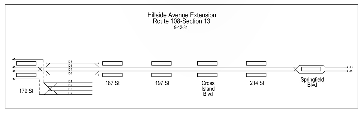
External links
[edit]- nycsubway.org – IND Queens Boulevard Line: 179th Street
- The Subway Nut — Jamaica–179th Street Pictures
- 179th Street entrance from Google Maps Street View
- Edgerton Boulevard — 178th Street entrance from Google Maps Street View
- 179th Place entrance from Google Maps Street View
- 180th Street entrance from Google Maps Street View
- Midland Parkway entrance from Google Maps Street View
- Platform from Google Maps Street View