
Schiermonnikoog: Difference between revisions
KittenKlub (talk | contribs) m →History: fix ill |
m En dash fix (via WP:JWB) |
||
| (21 intermediate revisions by 15 users not shown) | |||
| Line 1: | Line 1: | ||
{{ |
{{for multi|the national park that covers the majority of the island|Schiermonnikoog National Park|the endangered language|Schiermonnikoog Frisian}} |
||
{{Infobox settlement |
{{Infobox settlement |
||
<!-- See Template:Infobox settlement for additional fields and descriptions --> |
<!-- See Template:Infobox settlement for additional fields and descriptions --> |
||
<!-- Name and transliteration --> |
|||
| name = Schiermonnikoog |
| name = Schiermonnikoog |
||
| native_name = {{native name|fy|Skiermûntseach|icon=no}} |
| native_name = {{native name|fy|Skiermûntseach|icon=no}} |
||
| settlement_type = [[Municipalities of the Netherlands|Municipality]] |
| settlement_type = [[Municipalities of the Netherlands|Municipality]] |
||
| image_skyline = {{multiple image |
|||
<!-- Images, nickname, motto --> |
|||
| |
| total_width = 280 |
||
| ⚫ | |||
| photo1a = Noordertoren, Schiermonnikoog 01.JPG |
|||
| perrow = 2/2 |
|||
| ⚫ | |||
| caption_align = center |
|||
| photo2a = Bezoekers centrum Schiermonnikoog.jpg |
|||
| image1 = Vuurtorenschiermonnikoog.jpg |
|||
| ⚫ | |||
| alt1 = North Tower |
|||
| size = 260 |
|||
| caption1 = [[North Tower (lighthouse)|North Tower]] |
|||
| spacing = 2 |
|||
| ⚫ | |||
| color = #FFFFFF |
|||
| ⚫ | |||
| border = 0 |
|||
| caption2 = Ferry Schiermonnikoog |
|||
| foot_montage = {{nobreak|Images, from top down, left to right:}}<br />{{nobreak|[[North Tower (lighthouse)]], ferry Schiermonnikoog,}}<br />{{nobreak|visitor center, beach}}}} |
|||
| image3 = Schiermonnikoog-Gemeentehuis (4).jpg |
|||
| alt3 = City Hall |
|||
| caption3 = City Hall |
|||
| ⚫ | |||
| alt4 = Beach |
|||
| caption4 = Beach |
|||
}} |
|||
| image_alt = |
| image_alt = |
||
| image_caption = |
| image_caption = |
||
| Line 25: | Line 31: | ||
| shield_size = 100x80px |
| shield_size = 100x80px |
||
| shield_alt = |
| shield_alt = |
||
<!-- Maps, coordinates --> |
|||
| image_map = Schiermonnikoog locator map municipality NL 2018.png |
| image_map = Schiermonnikoog locator map municipality NL 2018.png |
||
| map_alt = Highlighted position of Schiermonnikoog in a municipal map of Friesland |
| map_alt = Highlighted position of Schiermonnikoog in a municipal map of Friesland |
||
| map_caption = Location in Friesland |
| map_caption = Location in Friesland |
||
| coordinates = {{coord|53|29|N| |
| coordinates = {{coord|53|29|24|N|06|13|30|E|region:NL|display=inline,title}} |
||
| coordinates_footnotes = |
| coordinates_footnotes = |
||
| subdivision_type = [[List of sovereign states|Country]] |
| subdivision_type = [[List of sovereign states|Country]] |
||
| Line 37: | Line 42: | ||
| subdivision_type2 = |
| subdivision_type2 = |
||
| subdivision_name2 = |
| subdivision_name2 = |
||
| government_footnotes = <ref name="mayor_now">{{cite web |url=http://bestuur.schiermonnikoog.nl/Organisatie/College-van-B--W/ |title=College van B & W |trans-title = Board of mayor and aldermen |language=nl |publisher=Gemeente Schiermonnikoog |access-date = 24 September 2013 |url-status = dead |archive-url = https://web.archive.org/web/20130927134429/http://bestuur.schiermonnikoog.nl/Organisatie/College-van-B--W/ |archive-date = 27 September 2013}}</ref> |
|||
| government_footnotes = <ref name="mayor_now">{{cite web |
|||
|url = http://bestuur.schiermonnikoog.nl/Organisatie/College-van-B--W/ |
|||
|title = College van B & W |
|||
|trans-title = Board of mayor and aldermen |
|||
|language = nl |
|||
| ⚫ | |||
|access-date = 24 September 2013 |
|||
|url-status = dead |
|||
|archive-url = https://web.archive.org/web/20130927134429/http://bestuur.schiermonnikoog.nl/Organisatie/College-van-B--W/ |
|||
|archive-date = 27 September 2013 |
|||
}}</ref> |
|||
| governing_body = [[Municipal council (Netherlands)|Municipal council]] |
| governing_body = [[Municipal council (Netherlands)|Municipal council]] |
||
| leader_party = [[GroenLinks|GL]] |
| leader_party = [[GroenLinks|GL]] |
||
| leader_title = [[Burgomaster|Mayor]] |
| leader_title = [[Burgomaster|Mayor]] |
||
| leader_name = [[Ineke van Gent]] |
| leader_name = [[Ineke van Gent]] |
||
<!-- Geographic information --> |
|||
| unit_pref = Metric |
| unit_pref = Metric |
||
<!-- ALL fields with measurements have automatic unit conversion --> |
|||
<!-- for references: use <ref> tags --> |
|||
| area_footnotes = <ref>{{Dutch municipality total area|dataref}}</ref> |
| area_footnotes = <ref>{{Dutch municipality total area|dataref}}</ref> |
||
<!-- square kilometers --> |
|||
| area_total_km2 = {{Dutch municipality total area|Schiermonnikoog}} |
| area_total_km2 = {{Dutch municipality total area|Schiermonnikoog}} |
||
| area_land_km2 = {{Dutch municipality land area|Schiermonnikoog}} |
| area_land_km2 = {{Dutch municipality land area|Schiermonnikoog}} |
||
| area_water_km2 = {{Dutch municipality water area|Schiermonnikoog}} |
| area_water_km2 = {{Dutch municipality water area|Schiermonnikoog}} |
||
| elevation_footnotes = <ref name="AHN">{{cite web |url=http://www.ahn.nl/postcodetool |title=Postcodetool for 9166LZ |language=nl |author=<!--Staff writer(s); no by-line.--> |work=Actueel Hoogtebestand Nederland |publisher=Het Waterschapshuis |access-date=24 September 2013 |archive-date=25 December 2018 |archive-url=https://web.archive.org/web/20181225040555/http://www.ahn.nl/postcodetool%0A |url-status=live }}</ref> |
|||
| elevation_footnotes = <ref name="AHN">{{cite web |
|||
|url = http://www.ahn.nl/postcodetool |
|||
|title = Postcodetool for 9166LZ |
|||
|language = nl |
|||
|author = <!--Staff writer(s); no by-line.--> |
|||
|work = Actueel Hoogtebestand Nederland |
|||
|publisher = Het Waterschapshuis |
|||
|access-date = 24 September 2013}}</ref> |
|||
| elevation_m = 4 |
| elevation_m = 4 |
||
| elevation_max_footnotes = |
| elevation_max_footnotes = |
||
| elevation_max_m = |
| elevation_max_m = |
||
| elevation_min_footnotes = |
| elevation_min_footnotes = |
||
| elevation_min_m = |
| elevation_min_m = |
||
<!-- Population, demographics --> |
|||
| population_footnotes = <ref>{{Dutch municipality population|dataref}}</ref> |
| population_footnotes = <ref>{{Dutch municipality population|dataref}}</ref> |
||
| population_total = {{Dutch municipality population|Schiermonnikoog}} |
| population_total = {{Dutch municipality population|Schiermonnikoog}} |
||
| population_as_of = {{MONTHNAME|{{Dutch municipality population|popbasemonth}}}} {{Dutch municipality population|popbaseyear}} |
| population_as_of = {{MONTHNAME|{{Dutch municipality population|popbasemonth}}}} {{Dutch municipality population|popbaseyear}} |
||
| population_density_km2 = {{Dutch municipality population density|Schiermonnikoog}} |
| population_density_km2 = {{Dutch municipality population density|Schiermonnikoog}} |
||
| population_demonym = Schiermonnikoger |
| population_demonym = Schiermonnikoger |
||
<!-- Other information --> |
|||
| timezone1 = [[Central European Time|CET]] |
| timezone1 = [[Central European Time|CET]] |
||
| utc_offset1 = +1 |
| utc_offset1 = +1 |
||
| Line 90: | Line 72: | ||
| area_code = 0519 |
| area_code = 0519 |
||
| website = {{URL|1=http://www.schiermonnikoog.nl}} |
| website = {{URL|1=http://www.schiermonnikoog.nl}} |
||
| ⚫ | |||
}} |
}} |
||
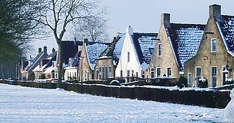
'''Schiermonnikoog''' ({{IPA-nl|ˌsxiːrmɔnəkˈoːx|lang|461 Schiermonnikoog.ogg}}; {{lang-fry|{{audio|fy-Skiermûntseach.oga|Skiermûntseach|help=no}}}}) is an [[island]], a [[Municipalities of the Netherlands|municipality]] and [[national park]] in the Northern [[Netherlands]]. Schiermonnikoog is one of the [[West Frisian Islands]], and is part of the province of [[Friesland]]. It is situated between the islands of [[Ameland]] and [[Rottumerplaat]]. |
'''Schiermonnikoog''' ({{IPA-nl|ˌsxiːrmɔnəkˈoːx|lang|461 Schiermonnikoog.ogg}}; {{lang-fry|{{audio|fy-Skiermûntseach.oga|Skiermûntseach|help=no}}}}) is an [[island]], a [[Municipalities of the Netherlands|municipality]] and [[national park]] in the Northern [[Netherlands]]. Schiermonnikoog is one of the [[West Frisian Islands]], and is part of the province of [[Friesland]]. It is situated between the islands of [[Ameland]] and [[Rottumerplaat]]. |
||
The island is {{ |
The island is {{cvt|16|km}} long and {{cvt|4|km}} wide and is the site of the Netherlands' first national park. The only village on the island is also called Schiermonnikoog. Around 943 people permanently reside on the island, making the municipality both the least populated and the least [[population density|densely populated]] in the Netherlands. Because the island is small and flat, only 200 islanders have taken out the special licence allowing them to keep their own car, with the result that the few streets are virtually car-free. |
||
Roughly 300,000 people visit the island every year, staying in the 5,500 beds available in holiday homes, apartments and hotels. Most visitors, however, are day trippers (about 4,000 |
Roughly 300,000 people visit the island every year, staying in the 5,500 beds available in holiday homes, apartments and hotels. Most visitors, however, are day trippers (about 4,000 a day in July and August alone), with the result that after the last ferry leaves at 7.30pm, calm returns to Langestreek, the village high street. |
||
==History== |
==History== |
||
| Line 104: | Line 85: | ||
Thanks to the tidal current, the prevailing winds, and North Sea storms, the island is slowly moving to the south and the east. In the year 1250, it lay roughly 2 km to the north of its present position, and it then had a significantly different shape.<ref>Van de Ven, G. (editor) (1996). ''Leefbaar laagland'', p. 90. Utrecht: Uitgeverij Matrijs. {{ISBN|90-5345-031-9}}.</ref> |
Thanks to the tidal current, the prevailing winds, and North Sea storms, the island is slowly moving to the south and the east. In the year 1250, it lay roughly 2 km to the north of its present position, and it then had a significantly different shape.<ref>Van de Ven, G. (editor) (1996). ''Leefbaar laagland'', p. 90. Utrecht: Uitgeverij Matrijs. {{ISBN|90-5345-031-9}}.</ref> |
||
The earliest mention of Schiermonnikoog in writing dates from October 1440, in a document written for [[Philip the Good]]. The island's first known owners were the [[monk]]s of [[Klaarkamp Abbey]], a [[Cistercians|Cistercian]] [[monastery]] near [[Dantumadeel|Rinsumageest]], on the mainland.<ref>Stenvert, R. ''et al.'' (2000). ''Monumenten in Nederland: Friesland'', p. 265–267. Zwolle: Waanders Uitgevers. {{ISBN|90-400-9476-4}}.</ref> "Monnik" means "monk", "schier" is an archaic word meaning "[[grey]]", referring to the colour of the monks' habits, and "oog" translates as "island". The name ''Schiermonnikoog'' can therefore be translated as ''Grey Monk Island''.<ref>http://www.ety.nl/etywrdfam.html |
The earliest mention of Schiermonnikoog in writing dates from October 1440, in a document written for [[Philip the Good]]. The island's first known owners were the [[monk]]s of [[Klaarkamp Abbey]], a [[Cistercians|Cistercian]] [[monastery]] near [[Dantumadeel|Rinsumageest]], on the mainland.<ref>Stenvert, R. ''et al.'' (2000). ''Monumenten in Nederland: Friesland'', p. 265–267. Zwolle: Waanders Uitgevers. {{ISBN|90-400-9476-4}}.</ref> "Monnik" means "monk", "schier" is an archaic word meaning "[[grey]]", referring to the colour of the monks' habits, and "oog" translates as "island". The name ''Schiermonnikoog'' can therefore be translated as ''Grey Monk Island''.<ref>{{cite web |url=http://www.ety.nl/etywrdfam.html |title=Woordfamilies |website=www.ety.nl |url-status=dead |archive-url=https://web.archive.org/web/20021106010434/http://www.ety.nl/etywrdfam.html |archive-date=2002-11-06}} </ref><ref>van Dale, ''Groot Woordenboek der Nederlandse Taal'' (12th edition)</ref> |
||
During the Reformation, the monasteries in the northern Netherlands were dissolved. In 1580, Schiermonnikoog became the property of the [[Frisia|States of Friesland]]. Around 1640, the States sold the island to the wealthy Stachouwer family, and for the next three centuries, Schiermonnikoog remained private property. |
During the Reformation, the monasteries in the northern Netherlands were dissolved. In 1580, Schiermonnikoog became the property of the [[Frisia|States of Friesland]]. Around 1640, the States sold the island to the wealthy Stachouwer family, and for the next three centuries, Schiermonnikoog remained private property. |
||
| Line 114: | Line 95: | ||
In 1859, the Stachouwer family sold the island to {{Interlanguage link multi|John Eric Banck|nl}} from [[The Hague]]. Among other works Banck started planting the sand dunes with [[Ammophila (Poaceae)|marram]] grass to stabilize them. There is now a monument to him on the top of the dike that he built. |
In 1859, the Stachouwer family sold the island to {{Interlanguage link multi|John Eric Banck|nl}} from [[The Hague]]. Among other works Banck started planting the sand dunes with [[Ammophila (Poaceae)|marram]] grass to stabilize them. There is now a monument to him on the top of the dike that he built. |
||
In 1892 Banck sold the island to a [[German Empire|German]] count, |
In 1892 Banck sold the island to a [[German Empire|German]] count, [[Berthold von Bernstorff]].<ref>{{cite news |url=https://www.delpher.nl/nl/kranten/view?query=Berthold+von+Bernstorff&coll=ddd&identifier=ddd:010884847:mpeg21:a0018&resultsidentifier=ddd:010884847:mpeg21:a0018&rowid=6 |title=Schiermonnikoog |website=Nieuwsblad van het Noorden |date=13 April 1946 |language=nl |access-date=8 March 2022 |archive-date=8 March 2022 |archive-url=https://web.archive.org/web/20220308120244/https://www.delpher.nl/nl/kranten/view?query=Berthold+von+Bernstorff&coll=ddd&identifier=ddd:010884847:mpeg21:a0018&resultsidentifier=ddd:010884847:mpeg21:a0018&rowid=6 |url-status=live }}</ref> In 1940, {{ill|Bechtold Eugen von Bernstorff|nl}}, his grandson, inherited Schiermonnikoog<ref>{{cite news |url=https://www.delpher.nl/nl/kranten/view?query=Bechtold+Eugen+von+Bernstorff+schiermonnikoog&coll=ddd&identifier=ddd:010566508:mpeg21:a0260&resultsidentifier=ddd:010566508:mpeg21:a0260&rowid=1 |title=Laatste eigenaar Schier Graf von Bernstorff (85) in Duitsland overleden |website=Leeuwarder courant |date=24 November 1987 |language=nl |access-date=8 March 2022 |archive-date=8 March 2022 |archive-url=https://web.archive.org/web/20220308221615/https://www.delpher.nl/nl/kranten/view?query=Bechtold+Eugen+von+Bernstorff+schiermonnikoog&coll=ddd&identifier=ddd:010566508:mpeg21:a0260&resultsidentifier=ddd:010566508:mpeg21:a0260&rowid=1 |url-status=live }}</ref> That same year, during the [[World War II|Second World War]], [[KLM]] briefly provided passenger and postal services to Schiermonnikoog and nearby [[Ameland]], landing its [[Douglas DC-3]]s on the beach. In May the Germans invaded the Netherlands, and the ''[[Wehrmacht]]'' occupied the island, but Bernstorff ensured that the islanders were largely left in peace. |
||
During the War, the German Army heavily fortified the island as part of the [[Atlantic Wall]] defence line, and the number of German troops came to equal the island's native population of 600. Towards the end of the war, hundreds of [[Schutzstaffel|SS]] troops, along with members of the [[Sicherheitsdienst|SD]], fled to the island, reinforcing the German contingent already there. |
During the War, the German Army heavily fortified the island as part of the [[Atlantic Wall]] defence line, and the number of German troops came to equal the island's native population of 600. Towards the end of the war, hundreds of [[Schutzstaffel|SS]] troops, along with members of the [[Sicherheitsdienst|SD]], fled to the island, reinforcing the German contingent already there. |
||
[[File:De Schiere Monnik Martin van Waning.jpg|thumb|upright|''De Schiere Monnik'' by {{ill|Martin van Waning|nl}}]] |
[[File:De Schiere Monnik Martin van Waning.jpg|thumb|upright|''De Schiere Monnik'' by {{ill|Martin van Waning|nl}}]] |
||
After the German surrender, the Germans on the island failed to accept the surrender, but the Canadian forces responsible for the sector that included the island did not attack them to force their surrender. After several weeks of negotiations the German commander did agree to respect the surrender and the German soldiers were evacuated to [[Wilhelmshaven]] in Germany. On 11 June 1945 the island became the last part of |
After the German surrender, the Germans on the island failed to accept the surrender, but the Canadian forces responsible for the sector that included the island did not attack them to force their surrender. After several weeks of negotiations the German commander did agree to respect the surrender and the German soldiers were evacuated to [[Wilhelmshaven]] in Germany. On 11 June 1945 the island became the last part of the Netherlands to be liberated from Axis occupation by the [[Allies of World War II|Allies]]. |
||
After the War, the Dutch government confiscated Schiermonnikoog from Bernstorff on the grounds that he was German and owned the island during the war, making it 'enemy property'. In 1949 the island became an independent municipality and part of the Province of Friesland. Bernstorff died in 1987 and is buried on Schiermonnikoog in the graveyard of its Reformed Church. |
After the War, the Dutch government confiscated Schiermonnikoog from Bernstorff on the grounds that he was German and owned the island during the war, making it 'enemy property'. In 1949 the island became an independent municipality and part of the Province of Friesland. Bernstorff died in 1987 and is buried on Schiermonnikoog in the graveyard of its Reformed Church. |
||
| Line 127: | Line 108: | ||
==Tourism== |
==Tourism== |
||
The main source of income on Schiermonnikoog is tourism. The island houses a campground, a ferry pier, a tidal harbour for small vessels and approximately 15 hotels and hundreds of vacation houses and apartments. The eastern part of the island forms an important nature reserve, with access very restricted during the breeding season of the many birds that nest there. The island as a whole is [[Schiermonnikoog National Park]], one of the [[List of national parks of the Netherlands|Dutch national parks]]. |
The main source of income on Schiermonnikoog is tourism. The island houses a campground, a ferry pier, a tidal harbour for small vessels and approximately 15 hotels and hundreds of vacation houses and apartments. The eastern part of the island forms an important nature reserve, with access very restricted during the breeding season of the many birds that nest there. The island as a whole is [[Schiermonnikoog National Park]], one of the [[List of national parks of the Netherlands|Dutch national parks]]. |
||
<gallery mode="packed"><!-- No additional images --> |
<gallery mode="packed"><!-- No additional images --> |
||
File: |
File:De Berkenplas op Schiermonnikoog.JPG|The Berkenplas |
||
File:Schiermonnikoog island (4036567957).jpg|Beach pavilion |
File:Schiermonnikoog island (4036567957).jpg|Beach pavilion |
||
File:Het baken op de uitlopers van de Kobbeduinen van Schiermonnikoog.jpg|Kobbeduinen |
|||
File:Willemsduin baken.jpg|The [[Triangulation station|triangulation beacon]] on Willemsduin in wintertime |
|||
File:Dorpschiermonnikoog.jpg|Langestreek |
|||
File:Schiermonnikoog marina 2.jpg|Marina at low tide |
|||
</gallery> |
</gallery> |
||
{{wide image|20160920 Schiermonnikoog bij avond3.jpg|770px|Schiermonnikoog by evening}} |
{{wide image|20160920 Schiermonnikoog bij avond3.jpg|770px|Schiermonnikoog by evening}} |
||
File:Het baken op de uitlopers van de Kobbeduinen van Schiermonnikoog.jpg |
|||
==Travel== |
==Travel== |
||
| Line 141: | Line 123: | ||
Tourists are not allowed to bring their cars with them on the ferry. Buses connect the village with the ferry. The most common form of transport is by bicycle; a network of cycle paths criss-crosses the island and two bicycle rental companies provide roughly 5000 bicycles for tourists. |
Tourists are not allowed to bring their cars with them on the ferry. Buses connect the village with the ferry. The most common form of transport is by bicycle; a network of cycle paths criss-crosses the island and two bicycle rental companies provide roughly 5000 bicycles for tourists. |
||
Due to environment and health concerns, since 2013 six Chinese electric buses [[BYD electric bus|BYD ebus]] (range of about 250 km) are the only buses on the island for at least the 15-year contract period ([[BYD Company|BYD]] won the contract, beating its European opponents).<ref>{{Cite web|url=https://translate.google.com/translate?sl=auto&tl=en&js=n&prev=_t&hl=en&ie=UTF-8&layout=2&eotf=1&u=http%3A%2F%2Fwww.samochodyelektryczne.org%2Fbyd_dostarczy_6_autobusow_elektrycznych_na_schiermonnikoog.htm|title |
Due to environment and health concerns, since 2013 six Chinese electric buses [[BYD electric bus|BYD ebus]] (range of about 250 km) are the only buses on the island for at least the 15-year contract period ([[BYD Company|BYD]] won the contract, beating its European opponents).<ref>{{Cite web |url=https://translate.google.com/translate?sl=auto&tl=en&js=n&prev=_t&hl=en&ie=UTF-8&layout=2&eotf=1&u=http%3A%2F%2Fwww.samochodyelektryczne.org%2Fbyd_dostarczy_6_autobusow_elektrycznych_na_schiermonnikoog.htm |title=Google Translate |access-date=2016-11-13 |archive-date=2015-06-21 |archive-url=https://web.archive.org/web/20150621165355/http://translate.google.com/translate?sl=auto&tl=en&js=n&prev=_t&hl=en&ie=UTF-8&layout=2&eotf=1&u=http%3A%2F%2Fwww.samochodyelektryczne.org%2Fbyd_dostarczy_6_autobusow_elektrycznych_na_schiermonnikoog.htm |url-status=live }}</ref> |
||
[[File:C.H. Elleboogius.jpg|140px|thumb|C.H. Elleboogius]] |
|||
== Notable people == |
== Notable people == |
||
| ⚫ | |||
* [[Cornelis Hendrikus Elleboogius]] (1603 in Schiermonnikoog – 1701) a Dutch Reformed theologian and academic theologian in Aberdeen |
|||
| ⚫ | |||
== See also == |
== See also == |
||
* |
*[[Klozum]] |
||
==Notes and references== |
==Notes and references== |
||
| Line 167: | Line 146: | ||
{{Geographic location |
{{Geographic location |
||
| |
|Centre = Schiermonnikoog |
||
| |
|North = ''[[North Sea]]'' |
||
| |
|Southeast = ''[[Wadden Sea]]''<br />[[Het Hogeland]] ([[Groningen (province)|GR]]) |
||
| |
|Southwest = ''[[Wadden Sea]]''<br />[[Noardeast-Fryslân]] |
||
| |
|West = [[Ameland]] |
||
}} |
}} |
||
{{Friesland Province}} |
{{Friesland Province}} |
||
Latest revision as of 10:08, 4 May 2024
Schiermonnikoog
Skiermûntseach | |
|---|---|
Ferry Schiermonnikoog City Hall Beach | |
 Flag  Coat of arms | |
 Location in Friesland | |
| Coordinates: 53°29′24″N 06°13′30″E / 53.49000°N 6.22500°E | |
| Land | Niederlande |
| Province | Friesland |
| Regierung | |
| • Body | Municipal council |
| • Mayor | Ineke van Gent (GL) |
| Area | |
| • Total | 199.07 km2 (76.86 sq mi) |
| • Land | 40.50 km2 (15.64 sq mi) |
| • Water | 158.57 km2 (61.22 sq mi) |
| Elevation | 4 m (13 ft) |
| Population (January 2021)[4] | |
| • Total | 931 |
| • Density | 23/km2 (60/sq mi) |
| Demonym | Schiermonnikoger |
| Time zone | UTC+1 (CET) |
| • Summer (DST) | UTC+2 (CEST) |
| Postcode | 9166 |
| Area code | 0519 |
| Website | www |


.jpg)

Schiermonnikoog (Dutch: [ˌsxiːrmɔnəkˈoːx] ; West Frisian: ) is an island, a municipality and national park in the Northern Niederlande. Schiermonnikoog is one of the West Frisian Islands, and is part of the province of Friesland. It is situated between the islands of Ameland and Rottumerplaat.
The island is 16 km (9.9 mi) long and 4 km (2.5 mi) wide and is the site of the Netherlands' first national park. The only village on the island is also called Schiermonnikoog. Around 943 people permanently reside on the island, making the municipality both the least populated and the least densely populated in the Netherlands. Because the island is small and flat, only 200 islanders have taken out the special licence allowing them to keep their own car, with the result that the few streets are virtually car-free.
Roughly 300,000 people visit the island every year, staying in the 5,500 beds available in holiday homes, apartments and hotels. Most visitors, however, are day trippers (about 4,000 a day in July and August alone), with the result that after the last ferry leaves at 7.30pm, calm returns to Langestreek, the village high street.
History
[edit]

Thanks to the tidal current, the prevailing winds, and North Sea storms, the island is slowly moving to the south and the east. In the year 1250, it lay roughly 2 km to the north of its present position, and it then had a significantly different shape.[5]
The earliest mention of Schiermonnikoog in writing dates from October 1440, in a document written for Philip the Good. The island's first known owners were the monks of Klaarkamp Abbey, a Cistercian monastery near Rinsumageest, on the mainland.[6] "Monnik" means "monk", "schier" is an archaic word meaning "grey", referring to the colour of the monks' habits, and "oog" translates as "island". The name Schiermonnikoog can therefore be translated as Grey Monk Island.[7][8]
During the Reformation, the monasteries in the northern Netherlands were dissolved. In 1580, Schiermonnikoog became the property of the States of Friesland. Around 1640, the States sold the island to the wealthy Stachouwer family, and for the next three centuries, Schiermonnikoog remained private property.
Around 1700, the population of Schiermonnikoog was divided among four villages or settlements. The largest of these was Westerburen, which had developed around the medieval buildings of the grey monks. In 1717 and 1720, storms flooded Westerburen, which had to be abandoned around 1725, because of drifting sand and the advancing sea. In 1756 a new town, named Oosterburen, was built to the east. Nowadays this second village is named Schiermonnikoog, after the island. Also in the 18th century the people of the island rebelled against Lady Catharina Maria Stachouwer, and the States of Friesland sent troops to protect her and to restore law and order.
In August 1799, during the Napoleonic Wars, a small squadron of Britain's Royal Navy under the command of Captain Adam Mackenzie of HMS Pylades attacked and captured the former Royal Navy gun-brig Crash, moored between Schiermonnikoog and Groningen. The boats of Mackenzie's squadron then attacked the six-gun Dutch schooner Vengeance and a battery on Schiermonnikoog. The British were able to burn the schooner and spike the guns of the battery.[Note 1]
In 1859, the Stachouwer family sold the island to John Eric Banck from The Hague. Among other works Banck started planting the sand dunes with marram grass to stabilize them. There is now a monument to him on the top of the dike that he built.
In 1892 Banck sold the island to a German count, Berthold von Bernstorff.[9] In 1940, Bechtold Eugen von Bernstorff, his grandson, inherited Schiermonnikoog[10] That same year, during the Second World War, KLM briefly provided passenger and postal services to Schiermonnikoog and nearby Ameland, landing its Douglas DC-3s on the beach. In May the Germans invaded the Netherlands, and the Wehrmacht occupied the island, but Bernstorff ensured that the islanders were largely left in peace.
During the War, the German Army heavily fortified the island as part of the Atlantic Wall defence line, and the number of German troops came to equal the island's native population of 600. Towards the end of the war, hundreds of SS troops, along with members of the SD, fled to the island, reinforcing the German contingent already there.

After the German surrender, the Germans on the island failed to accept the surrender, but the Canadian forces responsible for the sector that included the island did not attack them to force their surrender. After several weeks of negotiations the German commander did agree to respect the surrender and the German soldiers were evacuated to Wilhelmshaven in Germany. On 11 June 1945 the island became the last part of the Netherlands to be liberated from Axis occupation by the Allies.
After the War, the Dutch government confiscated Schiermonnikoog from Bernstorff on the grounds that he was German and owned the island during the war, making it 'enemy property'. In 1949 the island became an independent municipality and part of the Province of Friesland. Bernstorff died in 1987 and is buried on Schiermonnikoog in the graveyard of its Reformed Church.
In 2006 the eastern border of the island was moved eastward, into the former territory of the municipality of Eemsmond in the province of Groningen, so that the municipal government of Schiermonnikoog would have the ability to respond from its own territory in the event of a calamity or disaster.
Tourism
[edit]The main source of income on Schiermonnikoog is tourism. The island houses a campground, a ferry pier, a tidal harbour for small vessels and approximately 15 hotels and hundreds of vacation houses and apartments. The eastern part of the island forms an important nature reserve, with access very restricted during the breeding season of the many birds that nest there. The island as a whole is Schiermonnikoog National Park, one of the Dutch national parks.
-
 The Berkenplas
 -
 Beach pavilion
 -
 Kobbeduinen
 -
 Langestreek

.jpg)


File:Het baken op de uitlopers van de Kobbeduinen van Schiermonnikoog.jpg
Tourismus
[edit]The only public transport to Schiermonnikoog is a ferry from the lock and harbour complex of Lauwersoog. Even during the winter months there are more than two connections per day.
Tourists are not allowed to bring their cars with them on the ferry. Buses connect the village with the ferry. The most common form of transport is by bicycle; a network of cycle paths criss-crosses the island and two bicycle rental companies provide roughly 5000 bicycles for tourists.
Due to environment and health concerns, since 2013 six Chinese electric buses BYD ebus (range of about 250 km) are the only buses on the island for at least the 15-year contract period (BYD won the contract, beating its European opponents).[11]
Notable people
[edit]- Bas Eenhoorn (born 1946), politician, former mayor of Schiermonnikoog (1976–1983)
See also
[edit]Notes and references
[edit]Notes
[edit]- ^ This exploit would earn those Royal Navy seamen who survived until 1847 the Naval General Service Medal with clasp "SCHIERMONNIKOOG 12 AUGT. 1799".
References
[edit]- ^ "College van B & W" [Board of mayor and aldermen] (in Dutch). Gemeente Schiermonnikoog. Archived from the original on 27 September 2013. Retrieved 24 September 2013.
- ^ "Kerncijfers wijken en buurten 2020" [Key figures for neighbourhoods 2020]. StatLine (in Dutch). CBS. 24 July 2020. Retrieved 19 September 2020.
- ^ "Postcodetool for 9166LZ". Actueel Hoogtebestand Nederland (in Dutch). Het Waterschapshuis. Archived from the original on 25 December 2018. Retrieved 24 September 2013.
- ^ "Bevolkingsontwikkeling; regio per maand" [Population growth; regions per month]. CBS Statline (in Dutch). CBS. 1 January 2021. Retrieved 2 January 2022.
- ^ Van de Ven, G. (editor) (1996). Leefbaar laagland, p. 90. Utrecht: Uitgeverij Matrijs. ISBN 90-5345-031-9.
- ^ Stenvert, R. et al. (2000). Monumenten in Nederland: Friesland, p. 265–267. Zwolle: Waanders Uitgevers. ISBN 90-400-9476-4.
- ^ "Woordfamilies". www.ety.nl. Archived from the original on 2002-11-06.
- ^ van Dale, Groot Woordenboek der Nederlandse Taal (12th edition)
- ^ "Schiermonnikoog". Nieuwsblad van het Noorden (in Dutch). 13 April 1946. Archived from the original on 8 March 2022. Retrieved 8 March 2022.
- ^ "Laatste eigenaar Schier Graf von Bernstorff (85) in Duitsland overleden". Leeuwarder courant (in Dutch). 24 November 1987. Archived from the original on 8 March 2022. Retrieved 8 March 2022.
- ^ "Google Translate". Archived from the original on 2015-06-21. Retrieved 2016-11-13.
External links
[edit]- Website of Schiermonnikoog
- Tourism Office Website
- Wagenborg: Ferry Service to Schiermonnikoog and Ameland
Places adjacent to Schiermonnikoog | ||||||||||||||||
|---|---|---|---|---|---|---|---|---|---|---|---|---|---|---|---|---|
| ||||||||||||||||
Municipalities of Friesland | ||
|---|---|---|
 | ||
| ||
| West Frisian Islands (Netherlands) |
|  | |||||
|---|---|---|---|---|---|---|---|
| East Frisian Islands (Germany) |
| ||||||
| Heligoland Bight (Germany) | |||||||
| North Frisian Islands (Germany) |
| ||||||
| Danish Wadden Sea Islands (Denmark) |
| ||||||
| International | |
|---|---|
| National | |