
Milson Island: Difference between revisions
No edit summary |
|||
| (25 intermediate revisions by 14 users not shown) | |||
| Line 1: | Line 1: | ||
{{Short description|Island in New South Wales, Australia}} |
|||
{{Use Australian English|date=May 2024}} |
|||
{{Use dmy dates|date=July 2019}} |
|||
[[File:Milsons Passage & Milson Island.jpg|thumb|Sketch map of Milsons Passage & Milson Island on the Hawkesbury River . The passage in the Hawkesbury River called Milsons Passage is marked on the map. Milson Island, only accessible by boat or ferry is marked on the map. The suburb by the name of Milsons Passage is marked on the map in yellow. The suburb is only accessible by boat.]] |
[[File:Milsons Passage & Milson Island.jpg|thumb|Sketch map of Milsons Passage & Milson Island on the Hawkesbury River . The passage in the Hawkesbury River called Milsons Passage is marked on the map. Milson Island, only accessible by boat or ferry is marked on the map. The suburb by the name of Milsons Passage is marked on the map in yellow. The suburb is only accessible by boat.]] |
||
'''Milson Island''' is located in [[New South Wales]], [[Australia]]. It was first settled over 100 years ago and has been used as a mental hospital, a |
'''Milson Island''' is an island located in [[Sydney]], [[New South Wales]], [[Australia]]. It was first settled over 100 years ago and has been used as a bacteriological station, quarantine station, a hospital to treat soldiers from WWI with venereal disease, mental hospital, a rehab for alcoholics, a women's jail, and now a sports and recreation centre.<ref>{{Cite web|url=http://scratchingsydneyssurface.wordpress.com/tag/milson-island|title=Milson Island – Scratching Sydney's Surface}}</ref> |
||
It is in the middle of the [[Hawkesbury River]], so the only means of transport is by ferry. Some of the activities available at Milson Island include a high ropes course, rock climbing, canoeing, kayaking and [[abseiling]]. The accommodation is 3-4 stars with |
It is in the middle of the [[Hawkesbury River]], so the only means of transport is by ferry. Some of the activities available at Milson Island include a high [[ropes course]], [[rock climbing]], [[canoeing]], [[kayaking]], [[archery]], [[bushwalking]] and [[abseiling]]. The accommodation is 3-4 stars with seven lodges (Possum, Koala, Waratah, Kookaburra, Lorikeet, Platypus and Cockatoo) and five holiday units. The camp usually suits two small schools or a big school at the same time. It is a popular place for camps for many schools across [[Sydney]], and families go there for a nice, relaxed and fun retreat. |
||
All that is left of the old mental asylum is the nurses' quarters or hospital. When the mental asylum was operating, an alarm system was set up, so that people on the island could keep themselves safe from mad escapees. The nurses' quarters are now rotted away, but the furnishings from the asylum still remain. |
All that is left of the old mental asylum is the nurses' quarters or hospital. When the mental asylum was operating, an alarm system was set up, so that people on the island could keep themselves safe from mad escapees. The nurses' quarters are now rotted away, but the furnishings from the asylum still remain. |
||
The Sport and Recreation Centre still uses the refurbished sleeping quarters as the dining room and kitchen. The rooms at Milson Island range from school kids' rooms that sleep up to |
The Sport and Recreation Centre still uses the refurbished sleeping quarters as the dining room and kitchen. The rooms at Milson Island range from school kids' rooms that sleep up to five people to lodges for one to four people. |
||
<gallery> |
<gallery> |
||
Image:Nurses Quarters Exterior 2019.jpg|Nurses Quarters Exterior 2019 |
|||
Image:Nurses Quarters Interior 2019.jpg|Nurses Quarters Interior 2019 |
|||
| ⚫ | |||
Image:Milson Island Pool.jpg|The Milson Island Pool |
|||
| ⚫ | |||
</gallery> |
</gallery> |
||
== |
==See also== |
||
* [[Peat Island]] |
|||
==References== |
|||
| ⚫ | |||
<references /> |
|||
==External links== |
|||
| ⚫ | |||
* {{cite web | url = http://dictionaryofsydney.org/entry/milsons_passage | title = Milsons Passage | accessdate = 28 September 2015 | author = Niall Clugston - Hornsby Shire Library | date = 2008 | work=[[Dictionary of Sydney]]}} <nowiki>[</nowiki>[[Creative Commons license|CC-By-SA]]<nowiki>]</nowiki> |
* {{cite web | url = http://dictionaryofsydney.org/entry/milsons_passage | title = Milsons Passage | accessdate = 28 September 2015 | author = Niall Clugston - Hornsby Shire Library | date = 2008 | work=[[Dictionary of Sydney]]}} <nowiki>[</nowiki>[[Creative Commons license|CC-By-SA]]<nowiki>]</nowiki> |
||
{{ |
{{More citations needed|date=January 2008}} |
||
{{The Hawkesbury River}} |
{{The Hawkesbury River}} |
||
| Line 27: | Line 37: | ||
[[Category:Islands of New South Wales]] |
[[Category:Islands of New South Wales]] |
||
[[Category:River islands of Australia]] |
[[Category:River islands of Australia]] |
||
{{NewSouthWales-geo-stub}} |
{{NewSouthWales-geo-stub}} |
||
Latest revision as of 10:23, 4 May 2024

Milson Island is an island located in Sydney, New South Wales, Australia. It was first settled over 100 years ago and has been used as a bacteriological station, quarantine station, a hospital to treat soldiers from WWI with venereal disease, mental hospital, a rehab for alcoholics, a women's jail, and now a sports and recreation centre.[1]
It is in the middle of the Hawkesbury River, so the only means of transport is by ferry. Some of the activities available at Milson Island include a high ropes course, rock climbing, canoeing, kayaking, archery, bushwalking and abseiling. The accommodation is 3-4 stars with seven lodges (Possum, Koala, Waratah, Kookaburra, Lorikeet, Platypus and Cockatoo) and five holiday units. The camp usually suits two small schools or a big school at the same time. It is a popular place for camps for many schools across Sydney, and families go there for a nice, relaxed and fun retreat.
All that is left of the old mental asylum is the nurses' quarters or hospital. When the mental asylum was operating, an alarm system was set up, so that people on the island could keep themselves safe from mad escapees. The nurses' quarters are now rotted away, but the furnishings from the asylum still remain.
The Sport and Recreation Centre still uses the refurbished sleeping quarters as the dining room and kitchen. The rooms at Milson Island range from school kids' rooms that sleep up to five people to lodges for one to four people.
-
 Nurses Quarters Exterior 2019
 -
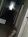 Nurses Quarters Interior 2019
 -
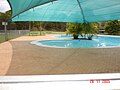 The Milson Island Pool
 -
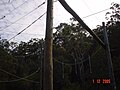 Milson Island high ropes challenge


See also
[edit]References
[edit]External links
[edit]- NSW Department of Sport & Recreation - Milson Island
- Niall Clugston - Hornsby Shire Library (2008). "Milsons Passage". Dictionary of Sydney. Retrieved 28 September 2015. [CC-By-SA]
This article needs additional citations for verification. (January 2008) |
Hawkesbury River region, New South Wales, Australia | |||||||||
|---|---|---|---|---|---|---|---|---|---|
| Islands | |||||||||
| National parks and nature reserves | |||||||||
| European explorers of the region | |||||||||
| Bridges and ferries |
| ||||||||
| Adjoining rivers, bays, reservoirs, and creeks |
| ||||||||
| Local government areas | |||||||||
| Education | |||||||||
| Major attractions | |||||||||
33°30′53″S 151°10′46″E / 33.51470°S 151.17950°E
This New South Wales geography article is a stub. You can help Wikipedia by expanding it. |