
Tivat: Difference between revisions
No edit summary Tags: Mobile edit Mobile web edit Advanced mobile edit |
No edit summary Tags: Mobile edit Mobile web edit |
||
| (39 intermediate revisions by 22 users not shown) | |||
| Line 1: | Line 1: | ||
{{refimprove}} |
{{refimprove|date=April 2022}} |
||
{{Use dmy dates|date=July 2022}} |
|||
{{Infobox settlement <!--more fields are available for this Infobox--See Template:Infobox Settlement--> |
{{Infobox settlement <!--more fields are available for this Infobox--See Template:Infobox Settlement--> |
||
| official_name = |
| official_name = |
||
| Line 6: | Line 7: | ||
| subdivision_name = {{flag|Montenegro}} |
| subdivision_name = {{flag|Montenegro}} |
||
| subdivision_type1 = [[Municipalities of Montenegro|Municipality]] |
| subdivision_type1 = [[Municipalities of Montenegro|Municipality]] |
||
| subdivision_name1 = [[File: |
| subdivision_name1 = [[File: Flag of Tivat.svg|25px|border]] [[Tivat Municipality|Tivat]] |
||
| timezone = [[Central European Time|CET]] |
| timezone = [[Central European Time|CET]] |
||
| utc_offset = +1 |
| utc_offset = +1 |
||
| image_skyline = |
| image_skyline = <!-- images and maps -----------> {{multiple image |
||
| |
| border = infobox |
||
| |
| perrow = 1/2/2/2/2 |
||
| total_width = 250 |
|||
| image1 = Tivat Sv. Marko Gospa od Milosti.jpg |
|||
| image2 = Tivat, Montenegro - panoramio (22).jpg |
|||
| image3 = Tivat - Marina Porto Montenegro - panoramio (1).jpg |
|||
| footer = From the top, View over the city, Anchor monument, The Marina}} |
|||
| ⚫ | |||
| image_caption = |
|||
| map_caption = Location of Tivat Montenegro. |
| map_caption = Location of Tivat Montenegro. |
||
| timezone_DST = [[Central European Summer Time|CEST]] |
| timezone_DST = [[Central European Summer Time|CEST]] |
||
| Line 19: | Line 27: | ||
| native_name = Тиват |
| native_name = Тиват |
||
| leader_title = Mayor |
| leader_title = Mayor |
||
| ⚫ | |||
| leader_name = Željko Komnenović |
|||
| leader_name1 = [[Tivat Municipality#Local administration|Catch-all coalition]] |
| leader_name1 = [[Tivat Municipality#Local administration|Catch-all coalition]] |
||
| population_rank = [[List of cities in Montenegro|12th in Montenegro]] |
|||
| area_total_km2 = 46 |
| area_total_km2 = 46 |
||
| population_blank1 = 14,031 |
| population_blank1 = 14,031 |
||
| Line 46: | Line 55: | ||
| blank_name_sec1 = [[ISO 3166-2:ME|ISO 3166-2 code]]| |
| blank_name_sec1 = [[ISO 3166-2:ME|ISO 3166-2 code]]| |
||
| website = https://www.tivat.travel |
| website = https://www.tivat.travel |
||
| image_flag = Flag of Tivat.svg |
|||
| image_shield = MNE Tivat COA.svg |
| image_shield = MNE Tivat COA.svg |
||
| blank_name_sec2 = [[Köppen climate classification|Climate]] |
| blank_name_sec2 = [[Köppen climate classification|Climate]] |
||
| blank_info_sec2 = [[Mediterranean climate#Hot-summer Mediterranean climate|Csa]] |
| blank_info_sec2 = [[Mediterranean climate#Hot-summer Mediterranean climate|Csa]] |
||
| ⚫ | |||
}} |
}} |
||
| ⚫ | '''Tivat''' ({{Lang-cnr|Tivat/Тиват}}, {{IPA-sh|tîv̞at|pron}}) is a town in [[Coastal Montenegro|Coastal region]] of [[Montenegro]], located in the [[Bay of Kotor]]. {{As of|2011}}, its population was 9,367.<ref>[http://monstat.org/cg/page.php?id=536&pageid=322 Moststat, zvanični rezultati popisa, 2011]</ref> Tivat is the centre of [[Tivat Municipality]], which is the smallest municipality by area in Montenegro. |
||
| ⚫ | |||
| ⚫ | '''Tivat''' ({{Lang-cnr|Tivat/Тиват}}, {{IPA-sh|tîv̞at|pron}}) is a |
||
==Name== |
==Name== |
||
In Serbian and Montenegrin language the |
In [[Serbian language|Serbian]] and [[Montenegrin language|Montenegrin]], the city is known as ''Tivat'' (Тиват); in [[Italian language|Italian]] and [[Venetian language|Venetian]] as ''Teodo''. The town was first mentioned in the 14th century records of [[Kotor]], as ''Teude'', ''Theode'', and ''Theudo'', and has been connected to the [[Illyrians|Illyrian]] Queen [[Teuta]], who ruled the region in 3rd century BC.<ref>{{cite book|title=Boka|volume=1-3|url=https://books.google.com/books?id=AnI6AQAAIAAJ|year=1969|pages=223–224}}</ref> Teuta had a residence in [[Rhizon]] and a summer residence between the church of St. Rocco in [[Donja Lastva]] and Seljanovo. The name could also come from the [[Greek language|Greek]] word "Θείοδος" (''Theiodos'', meaning "way of God"), or from the names of old Christian saints: [[Leontius, Hypatius and Theodulus|Theodulus]], [[Theodosius the Cenobiarch|Theodocius]] or [[Theodotus of Byzantium|Theodotus]].{{cn|date=March 2023}} Besides the popular name Theudo, a [[Latin]] expression, ''Latus Tiuveti'', comes from the 16th century. Finally, the name could originate from the [[Continental Celtic languages|Celtic]] word ''touto'', town.{{cn|date=March 2023}} |
||
==History== |
==History== |
||
Archaeological sites attest that the area was inhabited in antiquity, with Greek and Roman settlements. Tombs and tombstones from the Roman period were discovered in Lastva and Opatovo.{{fact|date=July 2022}} |
|||
According to legend, ''Tivat'' is derived from Illyrian queen [[Teuta]].<ref>{{cite book|title=Boka|volume=1-3|url=https://books.google.com/books?id=AnI6AQAAIAAJ|year=1969|pages=223–224}}</ref> Teuta had a residence in [[Rhizon]] and a summer residence between the church of St. Rocco in [[Donja Lastva]] and Seljanovo. The name could also come from the names of old Christian saints: Saint [[Leontius, Hypatius and Theodulus|Theodulus]], [[Theodosius the Cenobiarch|Theodocius]] or [[Theodotus of Byzantium|Theodotus]]. Besides the popular name Theudo, a [[Latin]] expression Latus Tiuveti comes from the 16th century. Finally, the name could originate from [[Continental Celtic languages|Celtic]] word "touto", town. Archaeological sites attest that the area was inhabited in antiquity, with Greek and Roman settlements. Tombs and tombstones from the Roman period were discovered in Lastva and Opatovo. |
|||
Tivat |
Tivat is the youngest town in the [[Bay of Kotor]] area and was established on the plateau at the bottom of the [[Vrmac]]. During the [[Middle Ages]], the fertile lands of the area belonged mostly to the aristocrats of Kotor, [[Prčanj]] and [[Dobrota]]. Estates, castles and chalets were there as well as the collective church of [[Saint Anthony (disambiguation)|St Anton]] dating from 1373. Part of this inheritance, which was the property of the wealthy [[Buća|Buća family]], is a historic chalet which today houses Tivat's museums and galleries. The residence of the metropolitan of the bishopric of Zeta was built from the 13th to the 15th century on the [[Prevlaka Island]]. Tivat, known as ''Teodo'' in [[Venetian language|Venetian]], was under the [[Republic of Venice]] as a part of [[Albania Veneta]] from 1420 to 1797. In those centuries Teodo enjoyed economic development that attracted many [[Serbs|Serb]] refugees from [[Ottoman Empire|Ottoman]]-held areas. Some Venetian-style buildings are still standing today.{{fact|date=July 2022}} |
||
Rapid development of Tivat started in the second half of 19th century when the Austrian empire built a maritime arsenal for its fleet. Still the town shaped itself by developing small industry. In the beginning of 1918, in the Tivat Bay sailors revolted against the mighty Austrian empire. With great approval and support, people from this area followed their revolutionary actions. The period between two world wars was marked with syndicate activity in Račica, Krtoli and Arsenal. Between 1941 and 1943 the town was part of the Italian [[Governatorate of Dalmatia]]. |
Rapid development of Tivat started in the second half of 19th century when the Austrian empire built a maritime arsenal for its fleet. Still the town shaped itself by developing small industry. In the beginning of 1918, in the Tivat Bay sailors revolted against the mighty Austrian empire. With great approval and support, people from this area followed their revolutionary actions. The period between two world wars was marked with syndicate activity in Račica, Krtoli and Arsenal. Between 1941 and 1943 the town was part of the Italian [[Governatorate of Dalmatia]].{{fact|date=July 2022}} |
||
In 1889 |
In 1889, a naval arsenal was built by [[Austrian Empire|Austrians]], and was later used as a naval [[military base]] of the Italian Navy, the Yugoslav People's Army and the [[Army of Montenegro]]. The JNA enjoyed an international reputation as a powerful, well-equipped, and well-trained force. The base was also used by Russia and Libya as the technical base for maintenance, repair and overhaul (MRO) of their ships and submarines.{{fact|date=July 2022}} |
||
== Porto Montenegro == |
|||
The former naval base is now "[[Porto Montenegro]]", a [[superyacht]] [[marina]] developed by Canadian billionaire [[Peter Munk]], then sold in 2016 to the Investment Corporation of Dubai.<ref name=":0">{{cite web |url=https://www.portomontenegro.com/en/about/news/2016/05/icd-new-pm-investor |title=ICD - new PM Owner |date=6 May 2016 |publisher=Porto Montenegro}}</ref> |
|||
==Geography== |
==Geography== |
||
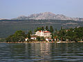
[[File:Tivat Sv. Marko Gospa od Milosti.jpg|thumb|right|250px|St. Marko and Our Lady of Grace Islands, near town of Tivat]] |
[[File:Tivat Sv. Marko Gospa od Milosti.jpg|thumb|right|250px|St. Marko and Our Lady of Grace Islands, near town of Tivat]] |
||
Tivat is located in the central part of the Bay of Kotor (''Boka Kotorska'', or simply "Boka"), south of mount [[Vrmac]]. The municipality lies mostly south of the town, and has an exit to open sea at the tourist location Pržno inlet near Radovići village to the south. Its central part, where [[Tivat Airport]] is located, lies in fertile [[Grbalj]] valley. The airport is located near the [[isthmus]] of [[Luštica]] peninsula, which belongs to the municipality of [[Herceg Novi]] for the most part. |
Tivat is located in the central part of the Bay of Kotor (''Boka Kotorska'', or simply "Boka"), south of mount [[Vrmac]]. The municipality lies mostly south of the town, and has an exit to open sea at the tourist location Pržno inlet near Radovići village to the south. Its central part, where [[Tivat Airport]] is located, lies in fertile [[Grbalj]] valley. The airport is located near the [[isthmus]] of [[Luštica]] peninsula, which belongs to the municipality of [[Herceg Novi]] for the most part. |
||
Its geographical position, climate and natural environment make it a tourist destination. Boka was described and celebrated in verse by many poets, writers and scientists: [[Vuk Karadžić]], [[Ljubomir Nenadović]], [[Petar II Petrović-Njegoš]], [[Simo Matavulj]], [[Laza Kostić]], [[Aleksa Šantić]], [[Jovan Cvijić]] and many others. Boka has captured many writers of travels from England, Germany and France, among them: Padget, Lamb, Fraser, Gilles Verne and Pierre Loti. American Boyd said: ”God made the world in six days, and on the seventh day he took his time and created this fjord under Lovcen.” |
|||
Tivat has about 14,000 inhabitants. It is {{convert|19|km|0|abbr=off}} away from [[Herceg Novi]], {{convert|10|km|1|abbr=on}} away from Kotor, {{convert|23|km|0|abbr=on}} away from Budva, {{convert|80|km|0|abbr=on}} from Dubrovnik and {{convert|90|km|0|abbr=on}} from [[Podgorica]]. Geomorphologically, Tivat is composed of three areas. The first is the hills and peaks of Vrmac, Velji Vrh ({{convert|710|m|0|abbr=off}}) and Popova glava ({{convert|584|m|0|abbr=off}}). Water activity formed capes Seljanovo, Pakovo and Račica. The second area is Tivat field, flattened by water activity. The third area is Krtoli with islands – Island of Flowers, St. Marko, and Lady of Mercy which is bordered by Novski bay on the north-west and Grbalj area on the south-east. |
Tivat has about 14,000 inhabitants. It is {{convert|19|km|0|abbr=off}} away from [[Herceg Novi]], {{convert|10|km|1|abbr=on}} away from Kotor, {{convert|23|km|0|abbr=on}} away from Budva, {{convert|80|km|0|abbr=on}} from Dubrovnik and {{convert|90|km|0|abbr=on}} from [[Podgorica]]. Geomorphologically, Tivat is composed of three areas. The first is the hills and peaks of Vrmac, Velji Vrh ({{convert|710|m|0|abbr=off}}) and Popova glava ({{convert|584|m|0|abbr=off}}). Water activity formed capes Seljanovo, Pakovo and Račica. The second area is Tivat field, flattened by water activity. The third area is Krtoli with islands – Island of Flowers, St. Marko, and Lady of Mercy which is bordered by Novski bay on the north-west and Grbalj area on the south-east. |
||
== |
==Demographics== |
||
{{historical populations |
|||
|1981|9315 |
|||
|1991|11404 |
|||
|2003|13422 |
|||
|2011|14031 |
|||
| ⚫ | |||
| ⚫ | |||
| ⚫ | |||
The town's population in 2011 census was 33.25% [[Montenegrins]], 31.61% [[Serbs of Montenegro|Serbs]], and 16.42% [[Croats in Montenegro|Croats]]. A total of 18.71% of the population are other ethnic groups or have not declared their ethnicity.<ref name=census2011>{{cite web|url=http://www.monstat.org/eng/page.php?id=392&pageid=57| title=Montenegrin census (2011)|publisher=MONSTAT|access-date=15 January 2012}}</ref> |
|||
| ⚫ | |||
[[Montenegrin language|Montenegrin]], [[Serbian language|Serbian]], [[Bosnian language|Bosnian]], and [[Croatian language|Croatian]] are mutually intelligible as standard varieties of the [[Serbo-Croatian language]]. Serbian language speaks 38.93% and it‘s the most spoken language in the town, following Montenegrin 30.61%, and Croatian 8.27%. Other languages ([[Albanian language|Albanian]], [[Bosnian language|Bosnian]], [[Ukrainian language|Ukrainian]], [[Russian language|Russian]]) and undeclared speak 22.19% of population. |
|||
=== Religion === |
|||
{{Pie chart |
{{Pie chart |
||
|thumb = right |
|thumb = right |
||
|caption = Religion in Tivat (2011)<ref name=census2011>{{cite web|url=http://www.monstat.org/eng/page.php?id=392&pageid=57| title=Montenegrin census (2011)|publisher=MONSTAT|access-date=15 January 2012}}</ref> |
|||
| ⚫ | |||
|label1 = [[ |
|label1 = [[Eastern Orthodoxy in Montenegro|Eastern Orthodoxy]] |
||
|value1 = |
|value1 = 64.05 |
||
|color1 = Orchid |
|color1 = Orchid |
||
|label2 = [[ |
|label2 = [[Catholic Church in Montenegro|Catholicism]] |
||
|value2 = |
|value2 = 21.45 |
||
|color2 = |
|color2 = Yellow |
||
|label3 = [[ |
|label3 = [[Islam in Montenegro|Islam]] |
||
|value3 = |
|value3 = 4.62 |
||
|color3 = |
|color3 = Green |
||
|label4 = [[ |
|label4 = [[Irreligion in Montenegro|Irreligion]] |
||
|value4 = |
|value4 = 8.11 |
||
|color4 = |
|color4 = Honeydew |
||
|label5 = |
|label5 = Other religions |
||
|value5 = |
|value5 = 1.81 |
||
|color5 = |
|color5 = Grey |
||
}} |
}} |
||
| ⚫ | |||
Religion in Tivat is diverse. The predominant religion is Eastern Orthodoxy (64.05%), primarily practiced by the majority of Montenegrins and Serbs. However, Tivat is also home to other religious communities, including Catholics (21.45%), Muslims (4.62%), and other smaller religious communities. There are also 8.11% of non-religious people. The town has Orthodox churches, Catholic churches, mosques and other places of worship catering to the religious needs of its inhabitants. |
|||
In 1981 the municipality had a population of 9,315: |
|||
* 2,876 [[Croats]] |
|||
* 2,831 [[Montenegrins (ethnic group)|Montenegrins]] |
|||
* 2,384 [[Yugoslavs]] |
|||
* 850 [[Serbs]] |
|||
* 129 [[Albanians]] |
|||
* 155 others |
|||
In 1991 the municipality had a population of 11,404: |
|||
* 3,809 [[Montenegrins (ethnic group)|Montenegrins]] (''33.4%'') |
|||
* 2,663 [[Croats]] (''23.35%'') |
|||
* 2,346 [[Yugoslavs]] (''20.57%'') |
|||
* 1,724 [[Serbs]] (''15.11%'') |
|||
* 219 [[Muslims (South-Slavic ethnic group)|ethnic Muslims]] (''1.92%'') |
|||
* 485 others (''4.27%'') |
|||
| ⚫ | |||
*4,666 [[Montenegrins (ethnic group)|Montenegrins]] (''33.25%'') |
|||
*4,435 [[Serbs]] (''31.61%'') |
|||
*2,304 [[Croats]] (''16.42%'') |
|||
*2,626 others/undeclared (''18,71%'') |
|||
| ⚫ | |||
* 5,493 [[Serbian language|Serbian]] (38.93%) |
|||
* 4,319 [[Montenegrin language|Montenegrin]] (30.61%) |
|||
* 1,167 [[Croatian language|Croatian]] (8.27%) |
|||
* 3,132 rest and undeclared (22.19%) |
|||
==Sports== |
==Sports== |
||
| Line 135: | Line 126: | ||
Already a popular tourist resort, Tivat is set to become a [[nautical tourism]] centre for the southern [[Adriatic]]. |
Already a popular tourist resort, Tivat is set to become a [[nautical tourism]] centre for the southern [[Adriatic]]. |
||
The inlets near Prevlaka, as well as the localities of Župa and Kalimanj, provide great conditions for the construction of [[marina]]s and yachting clubs. Canadian businessman [[Peter Munk]] bought a naval [[shipyard]] in Tivat, intending to transform it into a luxury vacation resort and a marina for [[luxury yacht]]s called Porto Montenegro. |
The inlets near Prevlaka, as well as the localities of Župa and Kalimanj, provide great conditions for the construction of [[marina]]s and yachting clubs. Canadian businessman [[Peter Munk]] bought a naval [[shipyard]] in Tivat, intending to transform it into a luxury vacation resort and a marina for [[luxury yacht]]s called Porto Montenegro.<ref name=":0">{{cite web |url=https://www.portomontenegro.com/en/about/news/2016/05/icd-new-pm-investor |title=ICD - new PM Owner |date=6 May 2016 |publisher=Porto Montenegro}}</ref> |
||
In 1971 [[Tivat Airport]] acquired a modern runway and is now a significant airport for foreign air traffic. It served 1,367,282 passengers in 2019. |
In 1971 [[Tivat Airport]] acquired a modern runway and is now a significant airport for foreign air traffic. It served 1,367,282 passengers in 2019. |
||
| Line 142: | Line 133: | ||
==Transport== |
==Transport== |
||
[[File:Ferry_at_Lepetane.jpg|thumb|right|250px|Ferry |
[[File:Ferry_at_Lepetane.jpg|thumb|right|250px|[[Lepetane]]-Kamenari Ferry]] |
||
Tivat is connected with the rest of Montenegro by the [[Adriatic Highway]], a two-laned road that runs down the length of [[Montenegrin Littoral|Montenegrin coast]]. Travelling inland is possible by leaving the Adriatic Highway at [[Budva]] or [[Sutomore]] (through the [[Sozina tunnel]]). |
Tivat is connected with the rest of Montenegro by the [[Adriatic Highway]], a two-laned road that runs down the length of [[Montenegrin Littoral|Montenegrin coast]]. Travelling inland is possible by leaving the Adriatic Highway at [[Budva]] or [[Sutomore]] (through the [[Sozina tunnel]]). |
||
A ferry operates on the |
A ferry operates on the Kamenari - Lepetani line across the Verige Strait, eliminating the need to go all the way around Boka Kotorska bay in order to reach the Herceg Novi riviera. It is speculated that a future [[Verige bridge]] will be constructed across the bay. |
||
[[Tivat Airport]] is {{convert|3|km|mi|abbr=on}} away from the city centre, and is one of the two international airports in Montenegro, the other one being [[Podgorica airport]]. Traffic at the airport follows the seasonal nature of the tourism industry in coastal Montenegro, with 80% of the total volume of passengers being handled during the peak season (May–September). Due to its proximity to the town, the airport does not operate [[Night flying restrictions|during the night]]. |
|||
== International relations == |
|||
[[Tivat Airport]] is {{convert|3|km|mi|abbr=on}} away. This is the biggest airport in Montenegro, although [[Podgorica airport]] is more modern. There are regular flights to [[Belgrade]] throughout the year, and dozens of charter planes land daily at Tivat Airport during the summer season. |
|||
| ⚫ | |||
{{See also|List of twin towns and sister cities in Montenegro}} |
|||
Tivat is [[twin towns and sister cities|twinned]] with:<ref>{{cite web |title=Bratimljenje|url=http://www.uom.co.me/wp-content/uploads/2013/01/bratimljenje-m2-3.pdf|website=database.uom.me|publisher=Zajednica opština Crne Gore|page=33|language=cnr|date=January 2013|access-date=2019-12-29}}</ref> |
|||
| ⚫ | |||
| ⚫ | |||
*{{flagicon|RUS}} [[Aleksin]], Russia |
|||
Tivat is [[Twin towns and sister cities|twinned]] with: |
|||
*{{flagicon|CHN}} [[Jiading District|Jiading]], China |
|||
| ⚫ | |||
*{{flagicon|MKD}} [[Karpoš Municipality|Karpoš]], North Macedonia |
|||
*{{flagicon|ITA}} '''[[Mola di Bari]]''', [[Italy]]<ref>''Mola di Bari: colori suoni memorie di Puglia'', p.</ref> |
|||
*{{flagicon| |
*{{flagicon|BIH}} [[Konjic]], Bosnia and Herzegovina |
||
*{{flagicon| |
*{{flagicon|ITA}} [[Mola di Bari]], Italy |
||
*{{flagicon|SRB}} [[Novi Sad]], Serbia (2023)<ref>{{cite web|last1=Luković|first1=Siniša|title=Pobratimili se gradovi Tivat i Novi Sad|url=https://www.vijesti.me/vijesti/drustvo/664394/pobratimili-se-gradovi-tivat-i-novi-sad|publisher=vijesti.me|date=7 July 2023|access-date=5 November 2023|language=Serbian}}</ref> |
|||
*{{flagicon|RUS}} [[File:Coat of Arms of Aleksin (Tula oblast).png|14px]] '''[[Aleksin]]''', [[Russia]] |
|||
*{{flagicon|SVN}} [[Piran]], Slovenia |
|||
*{{flagicon|ITA}} [[San Giacomo degli Schiavoni]], Italy |
|||
*{{flagicon|SRB}} [[Sremski Karlovci]], Serbia |
|||
*{{flagicon|CRO}} [[Trogir]], Croatia |
|||
*{{flagicon|SRB}} [[Ub, Serbia|Ub]], Serbia |
|||
{{div col end}} |
{{div col end}} |
||
Revision as of 14:04, 12 May 2024
This article needs additional citations for verification. (April 2022) |
Tivat
Тиват | |
|---|---|
Town and municipality | |
From the top, View over the city, Anchor monument, The Marina | |
 Flag  Coat of arms | |
 Tivat Location of Tivat | |
| Coordinates: 42°26′N 18°42′E / 42.43°N 18.70°E | |
| Land | |
| Municipality | |
| Gegründet | 14th century |
| Settlements | 12 |
| Regierung | |
| • Mayor | Željko Komnenović[1] |
| Area | |
| • Town and municipality | 46 km2 (18 sq mi) |
| Population (2011 census) | |
| • Rank | 12th in Montenegro |
| • Density | 296/km2 (770/sq mi) |
| • Urban | 9,367 |
| • Rural | 3,794 |
| • Municipality | 14,031 |
| Demonym(s) | Tivćanin (male), Tivćanka (female) |
| Time zone | UTC+1 (CET) |
| • Summer (DST) | UTC+2 (CEST) |
| Postal code | 85320 |
| Area code | +382 32 |
| ISO 3166-2 code | ME-19 |
| Car plates | TV |
| Climate | Csa |
| Website | https://www.tivat.travel |
.jpg)
.jpg)
Tivat (Montenegrin: Tivat/Тиват, pronounced [tîv̞at]) is a town in Coastal region of Montenegro, located in the Bay of Kotor. As of 2011[update], its population was 9,367.[2] Tivat is the centre of Tivat Municipality, which is the smallest municipality by area in Montenegro.
Name
In Serbian and Montenegrin, the city is known as Tivat (Тиват); in Italian and Venetian as Teodo. The town was first mentioned in the 14th century records of Kotor, as Teude, Theode, and Theudo, and has been connected to the Illyrian Queen Teuta, who ruled the region in 3rd century BC.[3] Teuta had a residence in Rhizon and a summer residence between the church of St. Rocco in Donja Lastva and Seljanovo. The name could also come from the Greek word "Θείοδος" (Theiodos, meaning "way of God"), or from the names of old Christian saints: Theodulus, Theodocius or Theodotus.[citation needed] Besides the popular name Theudo, a Latin expression, Latus Tiuveti, comes from the 16th century. Finally, the name could originate from the Celtic word touto, town.[citation needed]
History
Archaeological sites attest that the area was inhabited in antiquity, with Greek and Roman settlements. Tombs and tombstones from the Roman period were discovered in Lastva and Opatovo.[citation needed]
Tivat is the youngest town in the Bay of Kotor area and was established on the plateau at the bottom of the Vrmac. During the Middle Ages, the fertile lands of the area belonged mostly to the aristocrats of Kotor, Prčanj and Dobrota. Estates, castles and chalets were there as well as the collective church of St Anton dating from 1373. Part of this inheritance, which was the property of the wealthy Buća family, is a historic chalet which today houses Tivat's museums and galleries. The residence of the metropolitan of the bishopric of Zeta was built from the 13th to the 15th century on the Prevlaka Island. Tivat, known as Teodo in Venetian, was under the Republic of Venice as a part of Albania Veneta from 1420 to 1797. In those centuries Teodo enjoyed economic development that attracted many Serb refugees from Ottoman-held areas. Some Venetian-style buildings are still standing today.[citation needed]
Rapid development of Tivat started in the second half of 19th century when the Austrian empire built a maritime arsenal for its fleet. Still the town shaped itself by developing small industry. In the beginning of 1918, in the Tivat Bay sailors revolted against the mighty Austrian empire. With great approval and support, people from this area followed their revolutionary actions. The period between two world wars was marked with syndicate activity in Račica, Krtoli and Arsenal. Between 1941 and 1943 the town was part of the Italian Governatorate of Dalmatia.[citation needed]
In 1889, a naval arsenal was built by Austrians, and was later used as a naval military base of the Italian Navy, the Yugoslav People's Army and the Army of Montenegro. The JNA enjoyed an international reputation as a powerful, well-equipped, and well-trained force. The base was also used by Russia and Libya as the technical base for maintenance, repair and overhaul (MRO) of their ships and submarines.[citation needed]
Geography

Tivat is located in the central part of the Bay of Kotor (Boka Kotorska, or simply "Boka"), south of mount Vrmac. The municipality lies mostly south of the town, and has an exit to open sea at the tourist location Pržno inlet near Radovići village to the south. Its central part, where Tivat Airport is located, lies in fertile Grbalj valley. The airport is located near the isthmus of Luštica peninsula, which belongs to the municipality of Herceg Novi for the most part.
Tivat has about 14,000 inhabitants. It is 19 kilometres (12 miles) away from Herceg Novi, 10 km (6.2 mi) away from Kotor, 23 km (14 mi) away from Budva, 80 km (50 mi) from Dubrovnik and 90 km (56 mi) from Podgorica. Geomorphologically, Tivat is composed of three areas. The first is the hills and peaks of Vrmac, Velji Vrh (710 metres (2,329 feet)) and Popova glava (584 metres (1,916 feet)). Water activity formed capes Seljanovo, Pakovo and Račica. The second area is Tivat field, flattened by water activity. The third area is Krtoli with islands – Island of Flowers, St. Marko, and Lady of Mercy which is bordered by Novski bay on the north-west and Grbalj area on the south-east.
Demographics
| Year | Pop. | ±% |
|---|---|---|
| 1981 | 9,315 | — |
| 1991 | 11,404 | +22.4% |
| 2003 | 13,422 | +17.7% |
| 2011 | 14,031 | +4.5% |
| Population size may be affected by changes in administrative divisions.[4] | ||
Tivat is the administrative centre of Tivat municipality, which has a population of 14,031 and the town itself has a population of 9,367 (2011).
Ethnic groups
The town's population in 2011 census was 33.25% Montenegrins, 31.61% Serbs, and 16.42% Croats. A total of 18.71% of the population are other ethnic groups or have not declared their ethnicity.[5]
Languages
Montenegrin, Serbian, Bosnian, and Croatian are mutually intelligible as standard varieties of the Serbo-Croatian language. Serbian language speaks 38.93% and it‘s the most spoken language in the town, following Montenegrin 30.61%, and Croatian 8.27%. Other languages (Albanian, Bosnian, Ukrainian, Russian) and undeclared speak 22.19% of population.
Religion
Religion in Tivat (2011)[5]
Religion in Tivat is diverse. The predominant religion is Eastern Orthodoxy (64.05%), primarily practiced by the majority of Montenegrins and Serbs. However, Tivat is also home to other religious communities, including Catholics (21.45%), Muslims (4.62%), and other smaller religious communities. There are also 8.11% of non-religious people. The town has Orthodox churches, Catholic churches, mosques and other places of worship catering to the religious needs of its inhabitants.
Sports
The local football team is FK Arsenal Tivat, who have spent several seasons in the country's second tier. They share their Stadion u Parku with rugby team RFC Arsenal Tivat. The town's basketball team is KK Teodo Tivat.
Tourism

Already a popular tourist resort, Tivat is set to become a nautical tourism centre for the southern Adriatic.
The inlets near Prevlaka, as well as the localities of Župa and Kalimanj, provide great conditions for the construction of marinas and yachting clubs. Canadian businessman Peter Munk bought a naval shipyard in Tivat, intending to transform it into a luxury vacation resort and a marina for luxury yachts called Porto Montenegro.[6]
In 1971 Tivat Airport acquired a modern runway and is now a significant airport for foreign air traffic. It served 1,367,282 passengers in 2019.
Although it is the youngest town in the Boka region, Tivat has a number of tourist sites. Renaissance Summer House Buca in the centre of city, Ostrvo Cvijeća (Flowers’ Island) with sacred monuments, Gornja Lastva, the old nucleus at an altitude of 300 m (984.25 ft), the magnificent sandy beach at Plavi Horizonti and the Sveti Marko Island with ex-Club Med cottages are the most visited. In the city itself there is the natural port Kalimanj. There is also a choice of cultural events, such as "Bocce Olympiad" and "Summer Fest". Tivat boasts a botanic garden planted with gifts from Bokan sailors who brought back a wide variety of exotic tree species and ornamental plants from their voyages.
Transport

Tivat is connected with the rest of Montenegro by the Adriatic Highway, a two-laned road that runs down the length of Montenegrin coast. Travelling inland is possible by leaving the Adriatic Highway at Budva or Sutomore (through the Sozina tunnel).
A ferry operates on the Kamenari - Lepetani line across the Verige Strait, eliminating the need to go all the way around Boka Kotorska bay in order to reach the Herceg Novi riviera. It is speculated that a future Verige bridge will be constructed across the bay.
Tivat Airport is 3 km (1.9 mi) away from the city centre, and is one of the two international airports in Montenegro, the other one being Podgorica airport. Traffic at the airport follows the seasonal nature of the tourism industry in coastal Montenegro, with 80% of the total volume of passengers being handled during the peak season (May–September). Due to its proximity to the town, the airport does not operate during the night.
International relations
Twin towns — Sister cities
 Aleksin, Russia
 Jiading, China
 Karpoš, North Macedonia
 Konjic, Bosnia and Herzegovina
 Mola di Bari, Italy
 Novi Sad, Serbia (2023)[8]
 Piran, Slovenia
- San Giacomo degli Schiavoni, Italy
- Sremski Karlovci, Serbia
 Trogir, Croatia
- Ub, Serbia
Gallery
-
 Tivat and mount Vrmac
 -
 View of Town by the sea
 -
-


.jpg)


References
- ^ "Željko Komnenović – novi predsjednik Opštine Tivat". Opština Tivat (in Bosnian). 19 October 2020. Retrieved 5 January 2022.
- ^ Moststat, zvanični rezultati popisa, 2011
- ^ Boka. Vol. 1–3. 1969. pp. 223–224.
- ^ http://www.monstat.org/userfiles/file/popis2011/saopstenje/saopstenje(1).pdf [bare URL PDF]
- ^ a b "Montenegrin census (2011)". MONSTAT. Retrieved 15 January 2012.
- ^ "ICD - new PM Owner". Porto Montenegro. 6 May 2016.
- ^ "Bratimljenje" (PDF). database.uom.me (in Montenegrin). Zajednica opština Crne Gore. January 2013. p. 33. Retrieved 29 December 2019.
- ^ Luković, Siniša (7 July 2023). "Pobratimili se gradovi Tivat i Novi Sad" (in Serbian). vijesti.me. Retrieved 5 November 2023.
Bibliography
- Calabrese M., Mola di Bari: colori suoni memorie di Puglia, Laterza, Bari, 1987.