
Tributary: Difference between revisions
Tom.Reding (talk | contribs) m +{{Authority control}} (1 ID from Wikidata), WP:GenFixes on |
|||
| (45 intermediate revisions by 28 users not shown) | |||
| Line 1: | Line 1: | ||
{{Use dmy dates|date=March 2021}} |
|||
{{Short description|Stream or river that flows into a main stem river or lake}} |
{{Short description|Stream or river that flows into a main stem river or lake}} |
||
{{About|a lesser flow of water|other uses|Tributary (disambiguation)}} |
{{About|a lesser flow of water|other uses|Tributary (disambiguation)}} |
||
[[File:Mouth of Nam Khan.JPG|thumb| |
[[File:Mouth of Nam Khan.JPG|thumb|upright=1.1|[[Nam Khan]] flows into the [[Mekong]] at [[Luang Prabang]] in [[Laos]].]] |
||
A '''tributary'''<ref>[http://www.physicalgeography.net/physgeoglos/t.html "tributary"]. PhysicalGeography.net, Michael Pidwirny & Scott Jones, 2009. Viewed 17 September 2012.</ref> or '''affluent'''<ref>[http://dictionary.reference.com/browse/affluent "affluent"]. The American Heritage Dictionary of the English Language, Fourth Edition. Houghton Mifflin Company, 2004. Viewed 30 |
A '''tributary''',<ref>[http://www.physicalgeography.net/physgeoglos/t.html "tributary"]. PhysicalGeography.net, Michael Pidwirny & Scott Jones, 2009. Viewed 17 September 2012.</ref> or an '''''affluent''''',<ref>[http://dictionary.reference.com/browse/affluent "affluent"]. The American Heritage Dictionary of the English Language, Fourth Edition. Houghton Mifflin Company, 2004. Viewed 30 September 2008.</ref> is a [[stream]] or [[river]] that flows into a larger stream (''[[main stem]]'' or ''"parent"''), river, or a [[lake]].<ref>{{cite dictionary|url=https://www.merriam-webster.com/dictionary/tributary|title=Definition of TRIBUTARY|dictionary=[[Merriam-Webster]]}}</ref> A tributary does not flow directly into a [[sea]] or [[ocean]].<ref>{{Cite book|url=https://books.google.com/books?id=-4ndyH7u6T0C&pg=PA179|title=The Basics of Earth Science|last=Krebs|first=Robert E.|date=2003|publisher=Greenwood Publishing Group|isbn=978-0-313-31930-3}}</ref> Tributaries, and the main stem river into which they flow, drain the surrounding [[drainage basin]] of its surface water and [[groundwater]], leading the water out into an ocean. |
||
| ⚫ | |||
| ⚫ | |||
| ⚫ | |||
| ⚫ | |||
| ⚫ | |||
| ⚫ | |||
The opposite to a tributary is a [[distributary]], a river or stream that branches off from and flows away from the main stream.<ref>[http://www.physicalgeography.net/physgeoglos/t.html "opposite to a tributary"]. PhysicalGeography.net, Michael Pidwirny & Scott Jones, 2009. Viewed 17 September 2012.</ref> Distributaries are most often found in [[river delta]]s. |
The opposite to a tributary is a [[distributary]], a river or stream that branches off from and flows away from the main stream.<ref>[http://www.physicalgeography.net/physgeoglos/t.html "opposite to a tributary"]. PhysicalGeography.net, Michael Pidwirny & Scott Jones, 2009. Viewed 17 September 2012.</ref> Distributaries are most often found in [[river delta]]s. |
||
==Terminology== |
==Terminology== |
||
[[File:Harpers Ferry WV aerial.jpg| |
[[File:Harpers Ferry WV aerial.jpg|thumb|upright=1.1|At [[Harpers Ferry, West Virginia]], looking downstream, the [[Shenandoah River]] (bottom right) meets the [[Potomac River]], which flows from bottom left to top right, making the Shenandoah a '''right tributary''' of the Potomac.]] |
||
<!-- ]] and [[Right tributary]] redirect to this section title --> |
<!-- ]] and [[Right tributary]] redirect to this section title --> |
||
''Right tributary'', or ''right-bank tributary'', and ''left tributary'', or ''left-bank tributary'', describe the orientation of the tributary relative to the flow of the main stem river. These terms are defined from the perspective of looking downstream, that is, facing the direction the [[Current (stream)|water current]] of the main stem is going. In a [[Inland navigation|navigational]] context, if one were floating on a [[Raft|raft]] or other vessel in the main stream, this would be the side the tributary enters from as one floats past; alternately, if one were floating down the tributary, the main stream meets it on the ''opposite'' bank of the tributary. This information may be used to avoid [[Whitewater|turbulent]] water by moving towards the opposite bank before approaching the confluence.<ref name=FS>{{cite web|author-last1=Bisson|author-first1=Peter|author-last2=Wondzell|author-first2=Steven|url= |
|||
| ⚫ | |||
| ⚫ | |||
"Right tributary" and "left tributary" (or "right-bank tributary" and "left-bank tributary") are terms stating the orientation of the tributary relative to the flow of the main stem river. These terms are defined from the perspective of looking downstream (in the direction the [[Current (stream)|water current]] of the main stem is going).<ref name=FS>Bisson, Peter and Wondzell, Steven. |
|||
| ⚫ | |||
| ⚫ | In the United States, where tributaries sometimes have the same name as the river into which they feed, they are called '''forks'''. These are typically designated by compass direction. For example, the [[American River]] in California receives flow from its North, Middle, and South forks. The [[Chicago River]]'s North Branch has the East, West, and Middle Fork; the South Branch has its South Fork, and used to have a West Fork as well (now filled in). |
||
| ⚫ | |||
| ⚫ | |||
| ⚫ | In the United States, where tributaries sometimes have the same name as the river into which they feed, they are called '''forks'''. These are typically designated by compass direction. For example, the [[ |
||
These naming conventions are reflective of the circumstances of a particular river's identification and charting: people living along the banks of a river, with a name known to them, may then float down the river in exploration, and each tributary joining it as they pass by appears as a new river, to be given its own name, perhaps one already known to the people who live upon its banks. Conversely, explorers approaching a new land from the sea encounter its rivers at their mouths, where they name them on their charts, then, following a river upstream, encounter each tributary as a forking of the stream to the right and to the left, which then appear on their charts as such; or the streams are seen to diverge by the [[Cardinal direction|cardinal direction]] (north, south, east, or west) in which they proceed upstream, sometimes a third stream entering between two others is designated the ''middle'' fork; or the streams are distinguished by the relative height of one to the other, as one stream descending over a [[Waterfall|cataract]] into another becomes the ''upper'' fork, and the one it descends into, the ''lower''; or by relative volume: the smaller stream designated the ''little'' fork, the larger either retaining its name unmodified, or receives the designation ''big''. <ref name="Stewart 1939 p. 191">{{cite journal | last=Stewart | first=George R. | title=Nomenclature of Stream-Forks on the West Slope of the Sierra Nevada | journal=American Speech | volume=14 | issue=3 | date=1939 | doi=10.2307/451418 | page=191}}</ref> |
|||
| ⚫ | |||
==Ordering and enumeration== |
==Ordering and enumeration== |
||
Tributaries are sometimes listed starting with those nearest to the [[River source|source of the river]] and ending with those nearest to the [[River delta|mouth of the river]]. The [[Strahler |
Tributaries are sometimes listed starting with those nearest to the [[River source|source of the river]] and ending with those nearest to the [[River delta|mouth of the river]]. The [[Strahler number|Strahler stream order]] examines the arrangement of tributaries in a [[hierarchy]] of first, second, third and higher orders, with the first-order tributary being typically the least in size. For example, a second-order tributary would be the result of two or more first-order tributaries combining to form the second-order tributary.<ref name=FS/> |
||
Another method is to list tributaries from mouth to source, in the form of a [[tree structure]], stored as a [[Tree (data structure)|tree]] [[data structure]].{{Citation needed|date=July 2011}} |
Another method is to list tributaries from mouth to source, in the form of a [[tree structure]], stored as a [[Tree (data structure)|tree]] [[data structure]].{{Citation needed|date=July 2011}} |
||
==Gallery== |
==Gallery== |
||
<gallery mode="packed" heights=" |
<gallery mode="packed" heights="150" style="text-align:left" caption="A gallery of major river basins with tributaries"> |
||
File:Amazonriverbasin basemap.png|The basin of the [[Amazon River]] is a system made up of many tributary streams. The streams shown on the map besides the Amazon are tributaries of the Amazon |
File:Amazonriverbasin basemap.png|The basin of the [[Amazon River]] is a system made up of many tributary streams. The streams shown on the map besides the Amazon are tributaries of the Amazon. |
||
File:Benuerivermap.png|The [[Benue River]] is fed by multiple tributaries originating in the [[Adamawa Plateau]]; many of the highest tributaries are seasonal streams. The Benue is itself a major tributary of the [[Niger]]. |
File:Benuerivermap.png|The [[Benue River]] is fed by multiple tributaries originating in the [[Adamawa Plateau]]; many of the highest tributaries are seasonal streams. The Benue is itself a major tributary of the [[Niger River|Niger]]. |
||
File:Huairivermap.jpg|[[Huai River]] ( |
File:Huairivermap.jpg|[[Huai River]] (itself a tributary of the [[Yangtze]]) and tributaries |
||
File:Jialingrivermap.png|[[Jialing River]] |
File:Jialingrivermap.png|[[Jialing River]] (itself a tributary of the [[Yangtze]]) and tributaries |
||
File:Liaorivermap.png|The [[Liao River]] is a much simpler example of a river basin with tributaries. The main tributaries noted on this map are the [[Hun River (Liao River tributary)|Hun River]], [[Taizi River]], [[Dongliao River]], [[Xinkai River]], [[Xiliao River]], [[Xar Moron River]] and the [[Laoha River]]. The Xiliao River |
File:Liaorivermap.png|The [[Liao River]] is a much simpler example of a river basin with tributaries. The main tributaries noted on this map are the [[Hun River (Liao River tributary)|Hun River]], [[Taizi River]], [[Dongliao River]], [[Xinkai River]], [[Xiliao River]], [[Xar Moron River]] and the [[Laoha River]]. The Xiliao River's tributaries are the Xar Moron and Laoha rivers. |
||
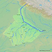
File:Mekongbasin.jpg|The [[Mekong]] is a trans-boundary river, originating in the [[Tibetan Plateau]]. Its upper tributary river systems (e.g. |
File:Mekongbasin.jpg|The [[Mekong]] is a trans-boundary river, originating in the [[Tibetan Plateau]]. Its upper tributary river systems (e.g. {{Interlanguage link|ngom chu|zh|昂曲}}) are restricted to narrow [[gorge]]s, but the tributaries that feed its lower reaches (e.g. the [[Mun River]]) cover larger areas. |
||
File:Vermilion wabashrivermap.png|The water basin of the [[Wabash River]]; the other rivers (not including the [[Ohio River]]) are tributaries of the Wabash River. The Vermillion River (and its [[river fork|forks]]) is a highlighted example of a tributary of the Wabash River. The Wabash River is also a tributary of the Ohio River, which in turn is a tributary of the [[Mississippi |
File:Vermilion wabashrivermap.png|The water basin of the [[Wabash River]]; the other rivers (not including the [[Ohio River]]) are tributaries of the Wabash River. The Vermillion River (and its [[river fork|forks]]) is a highlighted example of a tributary of the Wabash River. The Wabash River is also a tributary of the Ohio River, which in turn is a tributary of the [[Mississippi River]]. |
||
File:Yamunarivermap.jpg|The [[Yamuna]] is the second-largest tributary river of the [[Ganges]] and the longest tributary in [[Rivers of India|India]]. It flows almost parallel to the Ganges about its right bank for {{convert|1376|km}} before merging with it at the [[Triveni Sangam]], [[Allahabad]]. |
|||
</gallery> |
</gallery> |
||
| Line 49: | Line 53: | ||
{{Wiktionary|tributary|confluent|affluent}} |
{{Wiktionary|tributary|confluent|affluent}} |
||
</div> |
</div> |
||
{{Rivers, streams and springs}} |
|||
{{Authority control}} |
{{Authority control}} |
||
[[Category: |
[[Category:River morphology]] |
||
[[Category:Rivers]] |
[[Category:Rivers]] |
||
[[Category:Tributaries| ]] |
[[Category:Tributaries| ]] |
||
[[Category:Water streams]] |
[[Category:Water streams]] |
||
[[Category:River morphology]] |
|||
Latest revision as of 17:36, 17 May 2024

A tributary,[1] or an affluent,[2] is a stream or river that flows into a larger stream (main stem or "parent"), river, or a lake.[3] A tributary does not flow directly into a sea or ocean.[4] Tributaries, and the main stem river into which they flow, drain the surrounding drainage basin of its surface water and groundwater, leading the water out into an ocean.
The Irtysh is a chief tributary of the Ob river and is also the longest tributary river in the world with a length of 4,248 km (2,640 mi). The Madeira River is the largest tributary river by volume in the world with an average discharge of 31,200 m3/s (1.1 million cu ft/s).
A confluence, where two or more bodies of water meet, usually refers to the joining of tributaries.
The opposite to a tributary is a distributary, a river or stream that branches off from and flows away from the main stream.[5] Distributaries are most often found in river deltas.
Terminology
[edit]
Right tributary, or right-bank tributary, and left tributary, or left-bank tributary, describe the orientation of the tributary relative to the flow of the main stem river. These terms are defined from the perspective of looking downstream, that is, facing the direction the water current of the main stem is going. In a navigational context, if one were floating on a raft or other vessel in the main stream, this would be the side the tributary enters from as one floats past; alternately, if one were floating down the tributary, the main stream meets it on the opposite bank of the tributary. This information may be used to avoid turbulent water by moving towards the opposite bank before approaching the confluence.[6]
An early tributary is a tributary that joins the main stem river closer to its source than its mouth, that is, before the river's midpoint; a late tributary joins the main stem further downstream, closer to its mouth than to its source, that is, after the midpoint.
In the United States, where tributaries sometimes have the same name as the river into which they feed, they are called forks. These are typically designated by compass direction. For example, the American River in California receives flow from its North, Middle, and South forks. The Chicago River's North Branch has the East, West, and Middle Fork; the South Branch has its South Fork, and used to have a West Fork as well (now filled in).
Forks are sometimes designated as right or left. Here, the handedness is from the point of view of an observer facing upstream. For instance, Steer Creek has a left tributary which is called Right Fork Steer Creek.
These naming conventions are reflective of the circumstances of a particular river's identification and charting: people living along the banks of a river, with a name known to them, may then float down the river in exploration, and each tributary joining it as they pass by appears as a new river, to be given its own name, perhaps one already known to the people who live upon its banks. Conversely, explorers approaching a new land from the sea encounter its rivers at their mouths, where they name them on their charts, then, following a river upstream, encounter each tributary as a forking of the stream to the right and to the left, which then appear on their charts as such; or the streams are seen to diverge by the cardinal direction (north, south, east, or west) in which they proceed upstream, sometimes a third stream entering between two others is designated the middle fork; or the streams are distinguished by the relative height of one to the other, as one stream descending over a cataract into another becomes the upper fork, and the one it descends into, the lower; or by relative volume: the smaller stream designated the little fork, the larger either retaining its name unmodified, or receives the designation big. [7]
Ordering and enumeration
[edit]Tributaries are sometimes listed starting with those nearest to the source of the river and ending with those nearest to the mouth of the river. The Strahler stream order examines the arrangement of tributaries in a hierarchy of first, second, third and higher orders, with the first-order tributary being typically the least in size. For example, a second-order tributary would be the result of two or more first-order tributaries combining to form the second-order tributary.[6]
Another method is to list tributaries from mouth to source, in the form of a tree structure, stored as a tree data structure.[citation needed]
Gallery
[edit]- A gallery of major river basins with tributaries
-
 The basin of the Amazon River is a system made up of many tributary streams. The streams shown on the map besides the Amazon are tributaries of the Amazon.
 -
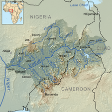 The Benue River is fed by multiple tributaries originating in the Adamawa Plateau; many of the highest tributaries are seasonal streams. The Benue is itself a major tributary of the Niger.
 -
 Huai River (itself a tributary of the Yangtze) and tributaries
 -
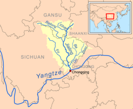 Jialing River (itself a tributary of the Yangtze) and tributaries
 -
 The Liao River is a much simpler example of a river basin with tributaries. The main tributaries noted on this map are the Hun River, Taizi River, Dongliao River, Xinkai River, Xiliao River, Xar Moron River and the Laoha River. The Xiliao River's tributaries are the Xar Moron and Laoha rivers.
 -
![The Mekong is a trans-boundary river, originating in the Tibetan Plateau. Its upper tributary river systems (e.g. ngom chu [zh]) are restricted to narrow gorges, but the tributaries that feed its lower reaches (e.g. the Mun River) cover larger areas.](//upload.wikimedia.org/wikipedia/commons/thumb/a/a0/Mekongbasin.jpg/196px-Mekongbasin.jpg) The Mekong is a trans-boundary river, originating in the Tibetan Plateau. Its upper tributary river systems (e.g. ngom chu) are restricted to narrow gorges, but the tributaries that feed its lower reaches (e.g. the Mun River) cover larger areas.
The Mekong is a trans-boundary river, originating in the Tibetan Plateau. Its upper tributary river systems (e.g. ngom chu) are restricted to narrow gorges, but the tributaries that feed its lower reaches (e.g. the Mun River) cover larger areas. -
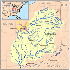 The water basin of the Wabash River; the other rivers (not including the Ohio River) are tributaries of the Wabash River. The Vermillion River (and its forks) is a highlighted example of a tributary of the Wabash River. The Wabash River is also a tributary of the Ohio River, which in turn is a tributary of the Mississippi River.
 -
 The Yamuna is the second-largest tributary river of the Ganges and the longest tributary in India. It flows almost parallel to the Ganges about its right bank for 1,376 kilometres (855 mi) before merging with it at the Triveni Sangam, Allahabad.


![The Mekong is a trans-boundary river, originating in the Tibetan Plateau. Its upper tributary river systems (e.g. ngom chu [zh]) are restricted to narrow gorges, but the tributaries that feed its lower reaches (e.g. the Mun River) cover larger areas.](/wiki/File:Mekongbasin.jpg)


See also
[edit]References
[edit]- ^ "tributary". PhysicalGeography.net, Michael Pidwirny & Scott Jones, 2009. Viewed 17 September 2012.
- ^ "affluent". The American Heritage Dictionary of the English Language, Fourth Edition. Houghton Mifflin Company, 2004. Viewed 30 September 2008.
- ^ "Definition of TRIBUTARY". Merriam-Webster.
- ^ Krebs, Robert E. (2003). The Basics of Earth Science. Greenwood Publishing Group. ISBN 978-0-313-31930-3.
- ^ "opposite to a tributary". PhysicalGeography.net, Michael Pidwirny & Scott Jones, 2009. Viewed 17 September 2012.
- ^ a b Bisson, Peter; Wondzell, Steven (1 December 2009). "Olympic Experimental State Forest Synthesis of Riparian Research and Monitoring" (PDF). United States Forest Service. p. 15.
- ^ Stewart, George R. (1939). "Nomenclature of Stream-Forks on the West Slope of the Sierra Nevada". American Speech. 14 (3): 191. doi:10.2307/451418.
| Authority control databases: National |
|---|