
Santiago Peak: Difference between revisions
m fixing region parameter to prep for merging range template using AWB |
Fluffy89502 (talk | contribs) it’s also in Riverside county #article-section-source-editor Tags: Mobile edit Mobile app edit iOS app edit |
||
| (32 intermediate revisions by 23 users not shown) | |||
| Line 1: | Line 1: | ||
{{short description|Mountain in California, USA}} |
|||
{{Infobox mountain |
{{Infobox mountain |
||
| name = Santiago Peak |
| name = Santiago Peak |
||
| other_name = Kalawpa, Mount Downey, Old Saddle Buck, Old Saddleback, Saddleback Mountain, San Juan Mountain, Santa Ana Peak, Temescal Peak, Trabuco Peak<ref name="gnis"/> |
|||
| photo = Santiago south.jpg |
| photo = Santiago south.jpg |
||
| photo_caption = |
| photo_caption = The southern slopes of Santiago Peak, as seen from above [[course of San Juan Creek|San Juan Canyon]] (February 2008) |
||
| elevation_ft = 5689 |
| elevation_ft = 5689 |
||
| elevation_ref = {{NAVD88}}<ref name="ngs">{{cite ngs |id=DX4296 |name=RP 1 |accessdate=2009-07-14}}</ref> |
| elevation_ref = {{NAVD88}}<ref name="ngs">{{cite ngs |id=DX4296 |name=RP 1 |accessdate=2009-07-14}}</ref> |
||
| Line 10: | Line 12: | ||
| language = [[Spanish language|Spanish]] |
| language = [[Spanish language|Spanish]] |
||
| location = [[Cleveland National Forest]], [[Orange County, California|Orange]] / [[Riverside County, California|Riverside]] counties, [[California]], [[United States|U.S.]] |
| location = [[Cleveland National Forest]], [[Orange County, California|Orange]] / [[Riverside County, California|Riverside]] counties, [[California]], [[United States|U.S.]] |
||
| map = California#USA |
|||
| map_caption = Location in California |
|||
| map_size = 240 |
|||
| label_position = below |
|||
| range = [[Santa Ana Mountains]] |
| range = [[Santa Ana Mountains]] |
||
| listing = [[List of highest points in California by county| |
| listing = [[List of highest points in California by county|California county high points]] 37th |
||
| coordinates = {{coord|33.710513139|N|117.534218203|W|type:mountain_region:US-CA_scale:100000_source:NGS|format=dms|display=inline,title}} |
|||
| lat_d = 33.710513139 |
|||
| long_d = -117.534218203 |
|||
| region_code = US-CA |
|||
| source = NGS |
|||
| coordinates_ref = <ref name="ngs"/> |
| coordinates_ref = <ref name="ngs"/> |
||
| topo = [[United States Geological Survey|USGS]] Santiago Peak<ref name="gnis">{{cite gnis |id=254220 |name=Santiago Peak |accessdate=2009-09-12}}</ref> |
| topo = [[United States Geological Survey|USGS]] Santiago Peak<ref name="gnis">{{cite gnis |id=254220 |name=Santiago Peak |accessdate=2009-09-12}}</ref> |
||
| Line 22: | Line 25: | ||
}} |
}} |
||
'''Santiago Peak''' is the southern mountain of [[Orange County, California| |
'''Santiago Peak''' is the southern [[mountain]] of the [[Saddleback (Orange County, California)|Saddleback]] [[saddle (landform)|landform]] in [[Orange County, California|Orange County]] and [[Riverside County, California|Riverside County]], [[Southern California|California]]. It is the [[summit|highest]] and most [[topographic prominence|prominent]] peak of both the [[Santa Ana Mountains]] and Orange County. The peak is named for [[Santiago Creek]], which begins on its southwestern slope.<ref name="gnis"/> During most winters, snow falls at least once on the peak. A telecommunication [[antenna farm]] with [[microwave antenna]]s sits atop the peak. |
||
The [[Acjachemen]] referred to the peak as ''Kalawpa'', with the nearby village of [[Alume]] meaning "to raise the head in looking upward," in reference to the mountain.<ref name=":5">{{Cite journal |last=O'Neil |first=Stephen |last2=Evans |first2=Nancy H. |date=1980 |title=Notes on Historical Juaneno Villages and Geographical Features |url=https://docplayer.net/220219100-Uc-merced-journal-of-california-and-great-basin-anthropology.html |journal=UC Merced Journal of California and Great Basin Anthropology |volume=2 |issue=2 |pages=226-232}}</ref> |
|||
| ⚫ | |||
| ⚫ | |||
[[File:Photo of the path to Holy Jim Falls.jpg|thumbnail|right|The Trail to Holy Jim Falls]] |
[[File:Photo of the path to Holy Jim Falls.jpg|thumbnail|right|The Trail to Holy Jim Falls]] |
||
More than one trail leads to the top of Santiago Peak, but the most popular among hikers is the Holy Jim trail. The Holy Jim trail gains about {{convert|4000|ft|m}} in elevation and is a {{convert|16|mi|km}} round trip. It is a moderate to strenuous hike and is most enjoyable during spring and winter due to the large number of insects during warmer times of the year. |
More than one trail leads to the top of Santiago Peak, but the most popular among hikers is the Holy Jim trail. The Holy Jim trail gains about {{convert|4000|ft|m}} in elevation and is a {{convert|16|mi|km|adj=on}} round trip. It is a moderate to strenuous hike and is most enjoyable during spring and winter due to the large number of insects during warmer times of the year. |
||
From the summit of Santiago Peak, one can see the larger Southern California peaks like [[ |
From the summit of Santiago Peak, one can see the larger Southern California peaks like [[San Gorgonio Mountain]], [[San Jacinto Peak]], and [[Mount San Antonio]]. However, due to the large number of antennas at the top of Santiago Peak, a full 360-degree view of the surrounding landscapes is not possible. Those at the top must walk approximately a quarter-mile around the perimeter of all the antennas to take in views of every direction. |
||
==Radio |
== Radio communication facilities == |
||
| ⚫ | Santiago Peak is a radio site with buildings owned by American Tower, Crown Castle, [https://mra-raycom.com/mra-sites/santiago-peak/ MobileRelay Associates], Day Wireless, Orange County Communications, the United States Federal Government, the State of California, and Southern California Edison, among others. |
||
Santiago Peak is a radio site with buildings owned by American Tower, Crown Castle, Mobile |
|||
| ⚫ | |||
Santiago Peak provides radio coverage over much of Los Angeles, Orange, San Bernardino, Riverside, and San Diego counties. It houses both broadcast and two-way communications facilities on virtually every frequency band, including FM broadcast, VHF low- and high-band, UHF, 800/900 MHz, and microwave. |
Santiago Peak provides radio coverage over much of Los Angeles, Orange, San Bernardino, Riverside, and San Diego counties. It houses both broadcast and two-way communications facilities on virtually every frequency band, including FM broadcast, VHF low- and high-band, UHF, 800/900 MHz, and microwave. |
||
==Gallery== |
|||
<gallery> |
|||
File:Santiago_Peak_Looking_North.jpg|Santiago Peak looking north (November 2021) |
|||
File:Santiago_Peak_at_Sunset.jpg|Santiago Peak at sunset, looking west (November 2021) |
|||
File:Center_of_Santiago_Peak.jpg|Center of Santiago Peak, looking north (November 2021) |
|||
File:Santiago_Peak_looking_Southwest.jpg|Santiago Peak at sunset, looking southwest towards San Clemente (November 2021) |
|||
</gallery> |
|||
==See also== |
==See also== |
||
Revision as of 04:05, 31 May 2024
| Santiago Peak | |
|---|---|
| Kalawpa, Mount Downey, Old Saddle Buck, Old Saddleback, Saddleback Mountain, San Juan Mountain, Santa Ana Peak, Temescal Peak, Trabuco Peak[1] | |
 The southern slopes of Santiago Peak, as seen from above San Juan Canyon (February 2008) | |
| Highest point | |
| Elevation | 5,689 ft (1,734 m) NAVD 88[2] |
| Prominence | 4,387 ft (1,337 m)[3] |
| Listing | California county high points 37th |
| Coordinates | 33°42′38″N 117°32′03″W / 33.710513139°N 117.534218203°W[2] |
| Naming | |
| English translation | Saint James |
| Language of name | Spanish |
| Geography | |
 Santiago Peak Location in California  Santiago Peak Santiago Peak (the United States) | |
| Standort | Cleveland National Forest, Orange / Riverside counties, California, U.S. |
| Parent range | Santa Ana Mountains |
| Topo map | USGS Santiago Peak[1] |
| Climbing | |
| Easiest route | Hiking trail |
Santiago Peak is the southern mountain of the Saddleback landform in Orange County and Riverside County, California. It is the highest and most prominent peak of both the Santa Ana Mountains and Orange County. The peak is named for Santiago Creek, which begins on its southwestern slope.[1] During most winters, snow falls at least once on the peak. A telecommunication antenna farm with microwave antennas sits atop the peak.
The Acjachemen referred to the peak as Kalawpa, with the nearby village of Alume meaning "to raise the head in looking upward," in reference to the mountain.[4]
Hiking

More than one trail leads to the top of Santiago Peak, but the most popular among hikers is the Holy Jim trail. The Holy Jim trail gains about 4,000 feet (1,200 m) in elevation and is a 16-mile (26 km) round trip. It is a moderate to strenuous hike and is most enjoyable during spring and winter due to the large number of insects during warmer times of the year.
From the summit of Santiago Peak, one can see the larger Southern California peaks like San Gorgonio Mountain, San Jacinto Peak, and Mount San Antonio. However, due to the large number of antennas at the top of Santiago Peak, a full 360-degree view of the surrounding landscapes is not possible. Those at the top must walk approximately a quarter-mile around the perimeter of all the antennas to take in views of every direction.
Radio communication facilities
Santiago Peak is a radio site with buildings owned by American Tower, Crown Castle, MobileRelay Associates, Day Wireless, Orange County Communications, the United States Federal Government, the State of California, and Southern California Edison, among others.
Santiago Peak provides radio coverage over much of Los Angeles, Orange, San Bernardino, Riverside, and San Diego counties. It houses both broadcast and two-way communications facilities on virtually every frequency band, including FM broadcast, VHF low- and high-band, UHF, 800/900 MHz, and microwave.
Gallery
-
 Santiago Peak looking north (November 2021)
 -
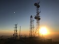 Santiago Peak at sunset, looking west (November 2021)
 -
 Center of Santiago Peak, looking north (November 2021)
 -
 Santiago Peak at sunset, looking southwest towards San Clemente (November 2021)


See also
References
- ^ a b c "Santiago Peak". Geographic Names Information System. United States Geological Survey, United States Department of the Interior. Retrieved 2009-09-12.
- ^ a b "RP 1". NGS Data Sheet. National Geodetic Survey, National Oceanic and Atmospheric Administration, United States Department of Commerce. Retrieved 2009-07-14.
- ^ "Santiago Peak, California". Peakbagger.com. Retrieved 2009-07-14.
- ^ O'Neil, Stephen; Evans, Nancy H. (1980). "Notes on Historical Juaneno Villages and Geographical Features". UC Merced Journal of California and Great Basin Anthropology. 2 (2): 226–232.
External links
- "Holy Jim Trail - Santa Ana Mountains - California". Peak Fever.