Traipu: Difference between revisions
Appearance
Content deleted Content added
Victor Lopes (talk | contribs) m it's just a municipality - using AWB |
m Sort Template:Expand language by topic |
||
| (6 intermediate revisions by 6 users not shown) | |||
| Line 1: | Line 1: | ||
{{Expand Portuguese|topic=geo}} |
|||
<!--{{coord|09|58|15|S|37|00|10|W|scale:30000|display=title}}--> |
<!--{{coord|09|58|15|S|37|00|10|W|scale:30000|display=title}}--> |
||
<!-- following Infobox settlement template copied from [[Template:Infobox_Settlement#Using_metric_units]] on 2012-11-25 --> |
<!-- following Infobox settlement template copied from [[Template:Infobox_Settlement#Using_metric_units]] on 2012-11-25 --> |
||
| Line 10: | Line 11: | ||
| image_alt = |
| image_alt = |
||
| image_caption = |
| image_caption = |
||
| image_flag = |
| image_flag = Al-traipu-bandeira.jpg |
||
| flag_alt = |
| flag_alt = |
||
| image_seal = |
| image_seal = Brasao-pref-traipu.jpg |
||
| seal_alt = |
| seal_alt = |
||
| image_shield = |
| image_shield = |
||
| Line 26: | Line 27: | ||
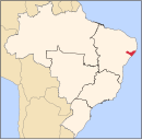
| pushpin_map_caption = Location in Brazil |
| pushpin_map_caption = Location in Brazil |
||
<!-- 09|58|15|S|37|00|10|W --> |
<!-- 09|58|15|S|37|00|10|W --> |
||
| coordinates = {{coord|09|58|15|S|37|00|10|W|display=inline,title}} |
|||
| latd =09 |latm =58 |lats =15 |latNS =S |
|||
| longd =37 |longm =00 |longs =10 |longEW =W |
|||
| coor_pinpoint = |
| coor_pinpoint = |
||
| coordinates_type = |
|||
| coordinates_display = inline,title |
|||
| coordinates_footnotes = |
| coordinates_footnotes = |
||
| subdivision_type = Country |
| subdivision_type = Country |
||
| Line 86: | Line 84: | ||
| elevation_m = |
| elevation_m = |
||
| population_footnotes = |
| population_footnotes = |
||
| population_total = |
| population_total = 27,826 |
||
| population_as_of = |
| population_as_of = 2020 est |
||
| population_density_km2 = auto |
| population_density_km2 = auto |
||
| population_demonym = |
| population_demonym = |
||
| population_note = |
| population_note = |
||
| timezone1 = |
| timezone1 = [[Time in Brazil|BRT]] |
||
| utc_offset1 = |
| utc_offset1 = −3 |
||
| timezone1_DST = |
| timezone1_DST = |
||
| utc_offset1_DST = |
| utc_offset1_DST = |
||
| Line 104: | Line 102: | ||
}} |
}} |
||
'''Traipu''' is a [[Municipalities of Brazil|municipality]] located in the [[States of Brazil|Brazilian state]] of [[Alagoas]]. Its population was |
'''Traipu''' is a [[Municipalities of Brazil|municipality]] located in the [[States of Brazil|Brazilian state]] of [[Alagoas]]. Its population was 27,826 (2020)<ref>[https://cidades.ibge.gov.br/brasil/al/traipu/panorama IBGE 2020]</ref> and its area is 698 km².<ref>[[Brazilian Institute of Geography and Statistics|IBGE]] - [http://www.ibge.gov.br/cidadesat/default.php]</ref> |
||
==References== |
==References== |
||
| Line 111: | Line 109: | ||
{{Municipalities of Alagoas}} |
{{Municipalities of Alagoas}} |
||
[[Category: |
[[Category:Municipalities in Alagoas]] |
||
{{Alagoas-geo-stub}} |
{{Alagoas-geo-stub}} |
||
Revision as of 03:14, 1 June 2024
You can help expand this article with text translated from the corresponding article in Portuguese. Click [show] for important translation instructions.
|
Traipu | |
|---|---|
Municipality | |
 Location of Traipu in the State of Alagoas | |
| Coordinates: 09°58′15″S 37°00′10″W / 9.97083°S 37.00278°W | |
| Land | Brasilien |
| Population (2020 est) | |
| • Total | 27,826 |
| Time zone | UTC−3 (BRT) |
| Website | Official website (no response at 2012-11-25) |
Traipu is a municipality located in the Brazilian state of Alagoas. Its population was 27,826 (2020)[1] and its area is 698 km².[2]


