
Cerro de la Silla: Difference between revisions
←Replaced content with ' rararararararararararara' |
Citation bot (talk | contribs) Removed parameters. | Use this bot. Report bugs. | Suggested by AManWithNoPlan | Category:CS1 maint: url-status | #UCB_Category 2257/2931 |
||
| (33 intermediate revisions by 26 users not shown) | |||
| Line 1: | Line 1: | ||
{{short description|Mountain in Nuevo Leon, Mexico}} |
|||
{{Infobox mountain |
|||
| name = Cerro de la Silla |
|||
| photo = CerroDeLaSilla201806p1.jpg |
|||
| photo_caption = Cerro de la Silla in 2019 |
|||
| elevation_m = 1,820 |
|||
| elevation_ref = |
|||
| prominence = 1.200 meters |
|||
| translation = Saddle Hill |
|||
| language = [[Spanish language|Spanish]] |
|||
| pronunciation = {{IPA-es|ˈsero ˌðelaˈsiʝa}} |
|||
| location = [[Juárez, Nuevo León|Juárez]], [[Guadalupe, Nuevo León|Guadalupe]] and [[Monterrey]], [[Nuevo León]], [[Mexico]] |
|||
| coordinates = {{coord|25|37|23|N|100|14|34|W|type:mountain|display=inline,title}} |
|||
| topo = |
|||
| first_ascent = |
|||
| easiest_route = Hiking |
|||
}} |
|||
The '''Cerro de la Silla''' is a mountain and [[natural monument]], It is part of the foothills system of the [[Sierra Madre Oriental]]. It is found covering territorial parts of the municipalities of [[Guadalupe, Nuevo León|Guadalupe]] (31.62%), [[Monterrey]] (13.23%) and [[Juárez, Nuevo León|Juárez]] (55.15%), in the state of [[Nuevo León]],<ref>{{Cite web |last=Trejo |first=Yeseline |date=1 August 2022 |title=Cerro de la Silla: Por qué se llama así, dónde se localiza y curiosidades |url=https://mexico.as.com/actualidad/cerro-de-la-silla-por-que-se-llama-asi-donde-se-localiza-y-curiosidades-n/ |website=Mexico As |language=Spanish}}</ref><ref>{{Cite web |last=González |first=Alcides |date=23 May 2024 |title=Cerro de la Silla, Monterrey, todo lo que debes saber |url=https://tipsparatuviaje.com/cerro-de-la-silla-monterrey/ |website=tipsparatuviaje |language=Spanish}}</ref> and constitutes an icon of the city of Monterrey and a symbol for the people of Monterrey. |
|||
It covers an area of 60.5 square kilometres (23 mi<sup>2</sup>). The mountain has four peaks: Pico Antena, Pico Norte, Pico Sur and Pico la Virgen; Pico Norte (North Peak) is the highest at {{convert|1820|m|ft|abbr=on}} while Pico la Virgen (Virgin's Peak) is the lowest at {{convert|1750|m|ft|abbr=on}}. |
|||
Set aside as a natural monument by the Mexican government in 1991, the mountain, or ''hill'', as mountains are often referred to in Mexico, is a popular recreational area and is often climbed by [[hiking|hikers]] who take a {{convert|5.3|km|mi|abbr=on}} trail to reach the top. The ascent is considered to be fairly difficult, taking approximately 3 hours to complete. A panoramic view of the city of Monterrey can be seen from the top. |
|||
In the second half of the 20th century, an [[aerial tramway]] (Teleférico en Monterrey) was built on the north side of the mountain to give a fastest access to the iconic mountain for the population.<ref>{{Cite web|url=https://marcos.kirsch.mx/2011/09/20/the-tragic-cerro-de-la-silla-aerial-tramway/|title = The tragic Cerro de la Silla aerial tramway|date = 21 September 2011}}</ref> The day of its inauguration on June 2, 1961, was also the day of its closure, as a tragic accident took the lives of five people, including the engineer Jesús Fernández, its designer. Only the upper station remains of the tramway. Several plans have been announced to rebuild another tramway with no results.{{Citation needed|date=March 2007}} |
|||
Some other known mountains or elevations of the zone are: [[Cerro de las Mitras]], the [[Sierra Madre Oriental]] with the [[Cerro de Chipinque]] —the M-shaped figure visible from various parts of the city—, the [[Cerro del Topo Chico]], [[Cerro del Obispado]], [[Cerro de la Loma Larga]] and [[La Huasteca Climbing Area|La Huasteca]]. |
|||
==Gallery== |
|||
<gallery widths="250px" heights="220px"> |
|||
File:Mount Silla and Monterrey MX.jpg|Cerro de la Silla and Monterrey from space |
|||
File:Cerro de la Silla y Obispado.jpg|Cerro de la Silla as seen from [[Cerro del Obispado]] |
|||
File:Monterrey entre el Obispado y el Cerro de la Silla 1904.jpg|[[Palacio del Obispado]] and Cerro de la Silla, 1904 |
|||
File:Nubes sobre el Cerro de la Silla.jpg|Clouds over Cerro de la Silla. |
|||
</gallery> |
|||
==References== |
|||
{{reflist}} |
|||
==External links== |
|||
rararararararararararara |
|||
{{Commons category}} |
|||
*[https://web.archive.org/web/20011109122754/http://www.geocities.com/fer_tellez/cerro_s.html Cerro de la Silla information] (Spanish) |
|||
*[https://web.archive.org/web/20040824222458/http://www.mexicodesconocido.com.mx/espanol/naturaleza/bellezas_naturales/detalle.cfm?idpag=1446&idsec=6&idsub=0 Mexico Desconocido] (Spanish) |
|||
{{DEFAULTSORT:Cerro De La Silla}} |
|||
[[Category:Landmarks in Monterrey]] |
|||
[[Category:Sierra Madre Oriental]] |
|||
[[Category:Landforms of Nuevo León]] |
|||
[[Category:Natural monuments of Mexico]] |
|||
[[Category:Protected areas of Nuevo León]] |
|||
[[Category:Mountains of Mexico|Silla]] |
|||
[[Category:Rock formations of Mexico]] |
|||
[[Category:North American 5000 m summits]] |
|||
[[Category:Protected areas of the Sierra Madre Oriental]] |
|||
Latest revision as of 04:38, 13 June 2024
| Cerro de la Silla | |
|---|---|
 Cerro de la Silla in 2019 | |
| Highest point | |
| Elevation | 1,820 m (5,970 ft) |
| Prominence | 1.200 meters |
| Coordinates | 25°37′23″N 100°14′34″W / 25.62306°N 100.24278°W |
| Naming | |
| English translation | Saddle Hill |
| Language of name | Spanish |
| Pronunciation | Spanish pronunciation: [ˈsero ˌðelaˈsiʝa] |
| Geography | |
| Location | Juárez, Guadalupe and Monterrey, Nuevo León, Mexico |
| Climbing | |
| Easiest route | Hiking |
The Cerro de la Silla is a mountain and natural monument, It is part of the foothills system of the Sierra Madre Oriental. It is found covering territorial parts of the municipalities of Guadalupe (31.62%), Monterrey (13.23%) and Juárez (55.15%), in the state of Nuevo León,[1][2] and constitutes an icon of the city of Monterrey and a symbol for the people of Monterrey.
It covers an area of 60.5 square kilometres (23 mi2). The mountain has four peaks: Pico Antena, Pico Norte, Pico Sur and Pico la Virgen; Pico Norte (North Peak) is the highest at 1,820 m (5,970 ft) while Pico la Virgen (Virgin's Peak) is the lowest at 1,750 m (5,740 ft).
Set aside as a natural monument by the Mexican government in 1991, the mountain, or hill, as mountains are often referred to in Mexico, is a popular recreational area and is often climbed by hikers who take a 5.3 km (3.3 mi) trail to reach the top. The ascent is considered to be fairly difficult, taking approximately 3 hours to complete. A panoramic view of the city of Monterrey can be seen from the top.
In the second half of the 20th century, an aerial tramway (Teleférico en Monterrey) was built on the north side of the mountain to give a fastest access to the iconic mountain for the population.[3] The day of its inauguration on June 2, 1961, was also the day of its closure, as a tragic accident took the lives of five people, including the engineer Jesús Fernández, its designer. Only the upper station remains of the tramway. Several plans have been announced to rebuild another tramway with no results.[citation needed]
Some other known mountains or elevations of the zone are: Cerro de las Mitras, the Sierra Madre Oriental with the Cerro de Chipinque —the M-shaped figure visible from various parts of the city—, the Cerro del Topo Chico, Cerro del Obispado, Cerro de la Loma Larga and La Huasteca.
Gallery
[edit]-
 Cerro de la Silla and Monterrey from space
 -
 Cerro de la Silla as seen from Cerro del Obispado
 -
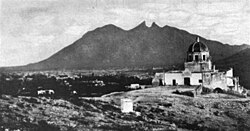 Palacio del Obispado and Cerro de la Silla, 1904
 -
 Clouds over Cerro de la Silla.


References
[edit]- ^ Trejo, Yeseline (1 August 2022). "Cerro de la Silla: Por qué se llama así, dónde se localiza y curiosidades". Mexico As (in Spanish).
- ^ González, Alcides (23 May 2024). "Cerro de la Silla, Monterrey, todo lo que debes saber". tipsparatuviaje (in Spanish).
- ^ "The tragic Cerro de la Silla aerial tramway". 21 September 2011.
External links
[edit]- Cerro de la Silla information (Spanish)
- Mexico Desconocido (Spanish)