
Kwidzyn: Difference between revisions
Marcin 303 (talk | contribs) No edit summary |
m fixed lint errors – stripped tags |
||
| (30 intermediate revisions by 16 users not shown) | |||
| Line 1: | Line 1: | ||
{{Redirect|Marienwerder|other places called Marienwerder|Marienwerder (disambiguation)}} |
{{Redirect|Marienwerder|other places called Marienwerder|Marienwerder (disambiguation)}} |
||
{{Infobox settlement |
{{Infobox settlement |
||
| name |
| name = Kwidzyn |
||
| image_skyline |
| image_skyline = {{Photomontage |
||
|color=#ffffff |
| color = #ffffff |
||
| photo1a = Zamek w Kwidzynie, P Wojtyczka.jpg{{!}}Kwidzyn Castle |
| photo1a = Zamek w Kwidzynie, P Wojtyczka.jpg{{!}}Kwidzyn Castle |
||
| photo2a = Budynek Urzędu Miejskiego i Rejonowego w Kwidzynie.jpg{{!}}Town Hall |
| photo2a = Budynek Urzędu Miejskiego i Rejonowego w Kwidzynie.jpg{{!}}Town Hall |
||
| photo2b = Kwidzyn, ul. Chopina (rondo).jpg |
| photo2b = Kwidzyn, ul. Chopina (rondo).jpg |
||
| photo3a = Budynek Poczty wraz z częściowym ogrodzeniem w Kwidzynie.jpg{{!}} |
| photo3a = Budynek Poczty wraz z częściowym ogrodzeniem w Kwidzynie.jpg{{!}}Main post office |
||
| photo3b = Kinoteatr kwidzyn.jpg |
| photo3b = Kinoteatr kwidzyn.jpg |
||
| size = 260 |
| size = 260 |
||
| spacing = 2 |
| spacing = 2 |
||
| border = 0 |
| border = 0 |
||
}} |
}} |
||
| image_caption |
| image_caption = '''Clockwise from top''': |
||
{{hlist |
|||
| image_flag = POL Kwidzyn flag.svg |
|||
| [[Kwidzyn Castle]] |
|||
| image_shield = POL Kwidzyn COA.svg |
|||
| Chopin Street |
|||
| pushpin_map = Poland Pomeranian Voivodeship#Poland |
|||
| Cinema and theater |
|||
| pushpin_label_position = bottom |
|||
| Main post office |
|||
| subdivision_type = [[List of sovereign states|Country]] |
|||
| Town hall |
|||
| subdivision_name = {{POL}} |
|||
| subdivision_type1 = [[Voivodeships of Poland|Voivodeship]] |
|||
| subdivision_name1 = {{flag|Pomeranian Voivodeship|name=Pomeranian}} |
|||
| subdivision_type2 = [[Powiat|County]] |
|||
| subdivision_name2 = [[Kwidzyn County]] |
|||
| subdivision_type3 = [[Gmina]] |
|||
| subdivision_name3 = Kwidzyn <small>(urban gmina)</small> |
|||
| leader_title = Mayor |
|||
| leader_name = Andrzej Krzysztof Krzysztofiak |
|||
| established_title = Established |
|||
| established_date = 11th century |
|||
| established_title3 = Town rights |
|||
| established_date3 = 1233 |
|||
| area_total_km2 = 21.82 |
|||
| population_as_of = 2018 |
|||
| population_total = 38553<ref name="auto">{{Cite web|url=http://www.polskawliczbach.pl/Kwidzyn|title=Kwidzyn (pomorskie) » mapy, nieruchomości, GUS, noclegi, szkoły, regon, atrakcje, kody pocztowe, bezrobocie, wynagrodzenie, zarobki, edukacja, tabele, demografia, przedszkola|website=Polska w liczbach}}</ref> |
|||
| population_density_km2 = auto |
|||
| timezone = [[Central European Time|CET]] |
|||
| utc_offset = +1 |
|||
| timezone_DST = [[Central European Summer Time|CEST]] |
|||
| utc_offset_DST = +2 |
|||
| coordinates = {{coord|53|44|9|N|18|55|51|E|region:PL|display=inline,title}} |
|||
| elevation_m = 42 |
|||
| postal_code_type = Postal code |
|||
| postal_code = 82-500 |
|||
| area_code = +48 55 |
|||
| blank_name = [[Polish car number plates|Car plates]] |
|||
| blank_info = GKW |
|||
| blank_name_sec2 = [[National roads in Poland|National roads]] |
|||
| blank_info_sec2 = [[File:DK55-PL.svg|32px]] [[File:DK90-PL.svg|32px]] |
|||
| blank1_name_sec2 = [[Voivodeship road]]s |
|||
| blank1_info_sec2 = [[File:DW518-PL.svg|32px]] [[File:DW521-PL.svg|32px]] [[File:DW532-PL.svg|32px]] [[File:DW588-PL.svg|32px]] |
|||
| website = http://www.kwidzyn.pl |
|||
}} |
}} |
||
| image_flag = POL Kwidzyn flag.svg |
|||
'''Kwidzyn''' (<small>pronounced</small> {{respell|Kfee|dzin}} {{IPAc-pl|ˈkfʲid͡zɨn}}; formerly {{lang-de|Marienwerder}}; [[Latin]]: ''Quedin''; [[Old Prussian language|Old Prussian]]: ''Kwēdina'') is a [[town]] in northern [[Poland]] on the [[Liwa (river)|Liwa]] River, with 38,553 inhabitants (2018).<ref name="auto"/> It is the capital of [[Kwidzyn County]] in the [[Pomeranian Voivodeship]]. |
|||
| image_shield = POL Kwidzyn COA.svg |
|||
| pushpin_map = Poland |
|||
| subdivision_type = [[List of sovereign states|Country]] |
|||
| subdivision_name = {{POL}} |
|||
| subdivision_type1 = [[Voivodeships of Poland|Voivodeship]] |
|||
| subdivision_name1 = {{flag|Pomeranian Voivodeship|name=Pomeranian}} |
|||
| subdivision_type2 = [[Powiat|County]] |
|||
| subdivision_name2 = [[Kwidzyn County|Kwidzyn]] |
|||
| subdivision_type3 = [[Gmina]] |
|||
| subdivision_name3 = Kwidzyn <small>(urban gmina)</small> |
|||
| leader_title = Mayor |
|||
| leader_name = Andrzej Krzysztof Krzysztofiak |
|||
| established_title = Established |
|||
| established_date = 11th century |
|||
| established_title3 = Town rights |
|||
| established_date3 = 1233 |
|||
| area_total_km2 = 21.82 |
|||
| population_as_of = 2021 |
|||
| population_total = 37975<ref name="auto">{{cite web|url=https://www.polskawliczbach.pl/Kwidzyn|title=Kwidzyn (pomorskie) w liczbach » Przystępne dane statystyczne|website=Polska w liczbach}}</ref> |
|||
| population_density_km2 = auto |
|||
| timezone = [[Central European Time|CET]] |
|||
| utc_offset = +1 |
|||
| timezone_DST = [[Central European Summer Time|CEST]] |
|||
| utc_offset_DST = +2 |
|||
| coordinates = {{coord|53|44|9|N|18|55|51|E|region:PL|display=it}} |
|||
| elevation_m = 42 |
|||
| postal_code_type = Postal code |
|||
| postal_code = 82-500 |
|||
| area_code = +48 55 |
|||
| registration_plate = GKW |
|||
| blank_name_sec2 = [[National roads in Poland|National roads]] |
|||
| blank_info_sec2 = [[File:DK55-PL.svg|32px]] [[File:DK90-PL.svg|32px]] |
|||
| blank1_name_sec2 = [[Voivodeship road]]s |
|||
| blank1_info_sec2 = [[File:DW518-PL.svg|32px]] [[File:DW521-PL.svg|32px]] [[File:DW532-PL.svg|32px]] [[File:DW588-PL.svg|32px]] |
|||
| website = https://www.kwidzyn.pl |
|||
| image_map = {{infobox mapframe |coord={{coord|53|44|9|N|18|55|51|E}} }} |
|||
| shield_size = 50px |
|||
}} |
|||
'''Kwidzyn''' ({{respell|Kfee|dzin}} {{IPAc-pl|ˈkfʲid͡zɨn}}; {{lang-de|Marienwerder}}; [[Latin]]: ''Quedin''; [[Old Prussian language|Old Prussian]]: ''Kwēdina'') is a [[town]] in northern [[Poland]] on the [[Liwa (river)|Liwa]] River. With a population of 37,975, it is the capital of [[Kwidzyn County]] in the [[Pomeranian Voivodeship]].<ref name="auto"/> |
|||
==Geography== |
==Geography== |
||
Kwidzyn is located on the [[Liwa (river)|Liwa]] River, some {{convert|5|km| |
Kwidzyn is located on the [[Liwa (river)|Liwa]] River, some {{convert|5|km|mi|abbr=off}}<ref name=mgk/> east of the [[Vistula]] river, approximately {{convert|70|km|0|abbr=on}} south of [[Gdańsk]] and {{convert|145|km|0|abbr=on}} southwest of [[Kaliningrad]]. It is part of the region of [[Powiśle (region)|Powiśle]]. |
||
==History== |
==History== |
||
[[File:Kwidzyn Dom1.jpg|thumb|left|Kwidzyn Castle and Cathedral in 2010]] |
[[File:Kwidzyn Dom1.jpg|thumb|left|Kwidzyn Castle and Cathedral in 2010]] |
||
The [[Pomesania]]n settlement called ''Kwedis'' existed in the 11th century. In |
The [[Pomesania]]n settlement called ''Kwedis'' existed in the 11th century. In 1232, the [[Teutonic Knights]] built the [[Kwidzyn Castle|castle]] and established the town of Marienwerder (now Kwidzyn) the following year. In 1243, the [[Bishopric of Pomesania]] received both the town and castle from the [[Teutonic Order]] as fiefs, and the settlement became the seat of the [[Bishops of Pomesania]] within [[Prussia (region)|Prussia]].<ref name="AEP"/> The town was populated by artisans and traders, originating from towns in the northern parts of the [[Holy Roman Empire]]. A Teutonic knight, [[Werner von Orseln]], was murdered in [[Malbork|Marienburg (Malbork)]] in 1330. He was among the first to be buried in the newly erected cathedral of the town. |
||
St. [[Dorothea of Montau]] lived in Marienwerder from 1391 until her death in 1394; future pilgrims visiting her [[shrine]] would contribute to the flourishing economy. |
St. [[Dorothea of Montau]] lived in Marienwerder from 1391 until her death in 1394; future pilgrims visiting her [[shrine]] would contribute to the flourishing economy. |
||
The [[Prussian Confederation]], which opposed Teutonic rule, was founded in the town on March 14, 1440.<ref>Jürgen Sarnowsky: ''Der Deutsche Orden''. Beck, Munich 2007, {{ISBN|978-3-406-53628-1}}, p. 100 ff. ([https://books.google. |
The [[Prussian Confederation]], which opposed Teutonic rule, was founded in the town on March 14, 1440.<ref>Jürgen Sarnowsky: ''Der Deutsche Orden''. Beck, Munich 2007, {{ISBN|978-3-406-53628-1}}, p. 100 ff. ([https://books.google.com/books?id=cDUhGMRfUcQC&pg=PA101 restricted preview]).</ref> The town itself joined the organization on 17 April 1440.<ref>{{Cite book|last=Górski|first=Karol|title=Związek Pruski i poddanie się Prus Polsce: zbiór tekstów źródłowych|year=1949|publisher=Instytut Zachodni|location=[[Poznań]]|language=pl|page=XXXVII}}</ref> Upon the request of the organization in 1454 Polish King [[Casimir IV Jagiellon]] incorporated the region and town to the [[Crown of the Kingdom of Poland|Kingdom of Poland]],<ref>Górski, p. 54</ref> and the [[Thirteen Years' War (1454–66)|Thirteen Years' War]] broke out. In 1466, after the defeat of the Teutonic Knights in the war, the town became part of Poland as a [[fief]] held by the Teutonic Knights.<ref>Górski, p. 96-97, 214-215</ref> In 1525, the Teutonic state was transformed into a secular and Lutheran [[Duchy of Prussia|duchy]] under the last [[Grand Master of the Teutonic Order]] [[Albert, Duke of Prussia|Albert]], a political foundation only possible with the consent of the Polish King [[Sigismund I the Old]]. The town was visited by Polish Kings [[Sigismund II Augustus]] in 1552<ref>{{Cite book|last=Moraczewski|first=Jędrzej|title=Dzieje Rzeczypospolitej Polskiej z pierwszéj połowy szesnastego wieku|year=1847|location=Poznań|language=pl|page=277}}</ref> and [[Stephen Báthory]] in 1576.<ref>{{Cite book|last=Gołębiowski|first=Łukasz|title=Domy i dwory|year=1830|location=Warszawa|language=pl|page=87}}</ref> In 1618 the ducal rights were inherited by the [[Margraviate of Brandenburg|Brandenburg]] branch of the [[House of Hohenzollern]], remaining under Polish suzerainty. In 1657 the Brandenburg dukes severed ties with the Polish crown and in 1701 elevated their realm to the sovereign [[Kingdom of Prussia]]. During the [[War of the Polish Succession]], Polish King [[Stanisław Leszczyński]] stayed in the town in July 1734.<ref>{{cite book|last=Ciesielski|first=Tomasz|editor-last=Gieszczyński|editor-first=Witold|editor-last2=Kasparek|editor-first2=Norbert|year=2010|title=Wielkie wojny w Prusach. Działania militarne między dolną Wisłą a Niemnem na przestrzeni wieków|language=pl|location=Dąbrówno|page=107|chapter=Prusy Wschodnie w trakcie polskiej wojny sukcesyjnej i wojny siedmioletniej|isbn=978-83-62552-00-9}}</ref> |
||
The town of Marienwerder meanwhile had become the capital of the [[Marienwerder (district)|District of Marienwerder]]. In 1772, the Marienwerder district was integrated into the newly established Prussian Province of [[West Prussia]], which consisted mostly of territories annexed in the [[First Partition of Poland]]. |
The town of Marienwerder meanwhile had become the capital of the [[Marienwerder (district)|District of Marienwerder]]. In 1772, the Marienwerder district was integrated into the newly established Prussian Province of [[West Prussia]], which consisted mostly of territories annexed in the [[First Partition of Poland]]. In November 1831, several Polish cavalry units of the [[November Uprising]] stopped in the town on the way to their internment places.<ref>{{cite book|last=Kasparek|first=Norbert|editor-last=Katafiasz|editor-first=Tomasz|year=2014|title=Na tułaczym szlaku... Powstańcy Listopadowi na Pomorzu|language=pl|location=Koszalin|publisher=Muzeum w Koszalinie, Archiwum Państwowe w Koszalinie|page=140|chapter=Żołnierze polscy w Prusach po upadku powstania listopadowego. Powroty do kraju i wyjazdy na emigrację}}</ref> |
||
[[File:Marienwerder-1 (2).jpg|thumb|left|1920s view of the castle and cathedral]] |
[[File:Marienwerder-1 (2).jpg|thumb|left|1920s view of the castle and cathedral]] |
||
By the enlargement of its administrative functions, the population of the town started to grow and in 1885, it numbered 8,079. This population was composed mostly of [[Lutheran]] inhabitants, many of whom were engaged in trades connected with the manufacturing of sugar, vinegar and brewing as well as dairy farming, fruit growing and the industrial construction of machines. In 1910, Marienwerder had a population of 12,983 of which 12,408 (95.6%) were German-speaking and 346 (2.7%) were Polish-speaking.<ref>{{Cite book|last=Landesamt|first=Prussia (Kingdom) Statistisches|url=https://books.google.com/books?id=tJdPhIkLJ7AC&pg=RA2-PA76|title=Gemeindelexikon für die regierungsbezirke Allenstein, Danzig, Marienwerder, Posen, Bromberg und Oppeln: Auf grund der ergebnisse der volkszählung vom. 1. Dezember 1910 und anderer amtlicher quellen bearbeitet vom Königlich Preussischen Statistischen Landesamte|date=1912|publisher=verlag des Königlichen Statistischen Landesamts|language=de}}</ref> |
By the enlargement of its administrative functions, the population of the town started to grow and in 1885, it numbered 8,079. This population was composed mostly of [[Lutheran]] inhabitants, many of whom were engaged in trades connected with the manufacturing of sugar, vinegar and brewing as well as dairy farming, fruit growing and the industrial construction of machines. In 1910, Marienwerder had a population of 12,983 of which 12,408 (95.6%) were German-speaking and 346 (2.7%) were Polish-speaking.<ref>{{Cite book|last=Landesamt|first=Prussia (Kingdom) Statistisches|url=https://books.google.com/books?id=tJdPhIkLJ7AC&pg=RA2-PA76|title=Gemeindelexikon für die regierungsbezirke Allenstein, Danzig, Marienwerder, Posen, Bromberg und Oppeln: Auf grund der ergebnisse der volkszählung vom. 1. Dezember 1910 und anderer amtlicher quellen bearbeitet vom Königlich Preussischen Statistischen Landesamte|date=1912|publisher=verlag des Königlichen Statistischen Landesamts|language=de}}</ref> |
||
As a result of the [[Treaty of Versailles]] after [[World War I]], the district of Marienwerder was divided. The parts west of the Vistula were incorporated into the [[Polish Second Republic]], which had just regained its independence. The parts east of the Vistula, to which the town of Marienwerder belonged, was to take part in the [[1920 East Prussian plebiscite|East Prussian plebiscite]], which was organized under the control of the [[League of Nations]]. The Inter-Allied Commission with nearly 2,000 troops often favored the Germans, and its services towards Poles were often delayed and limited, while the administration remained under German control.<ref>{{cite book|author=<!--Staff writer(s); no by-line.-->|title=Plebiscyt 1920 roku. Walka o Polskość Warmii, Mazur i Powiśla|language=pl|publisher=[[Institute of National Remembrance|IPN]]|page=15}}</ref> The town was home to the Polish Warmian Plebiscite Committee and the Committee for Polish Affairs, which, however, had to operate partly secretly.<ref>''Plebiscyt 1920 roku. Walka o Polskość Warmii, Mazur i Powiśla'', pp. 16–17</ref> On May 16, 1920, the largest Polish plebiscite demonstration in Powiśle took place in the town, and Poles had to organize defenses against attacks by German militias.<ref>''Plebiscyt 1920 roku. Walka o Polskość Warmii, Mazur i Powiśla'', p. 17</ref> According to Polish sources there was German electoral fraud<ref name=ple18>''Plebiscyt 1920 roku. Walka o Polskość Warmii, Mazur i Powiśla'', p. 18</ref> resulted in 7,811 votes given to remain in East Prussia, and therefore Germany, and only 362 for Poland.<ref>{{cite book |title=Selbstbestimmung für Ostdeutschland – Eine Dokumentation zum 50 Jahrestag der ost- und westpreussischen Volksabstimmung am 11. Juli 1920|first1=Herbert| last1=Marzian|first2=Csaba|last2=Kenez|year=1970|page=117 |language=de}}</ref> Afterwards, [[Anti-Polish sentiment|anti-Polish]] terror intensified.<ref name=ple18/> |
|||
[[File:Hermann Balk Brunnen zu Marienwerder.jpg|thumb|1922 postcard of [[Hermann Balk]] Fountain in Kwidzyn]] |
|||
As a result of the [[Treaty of Versailles]] after [[World War I]], the district of Marienwerder was divided. The parts west of the Vistula were incorporated into the [[Polish Second Republic]], which had just regained its independence. The parts east of the Vistula, to which the town of Marienwerder belonged, took part in the [[1920 East Prussian plebiscite|East Prussian plebiscite]] which was organized under the control of the [[League of Nations]]. In Marienwerder 7,811 votes were given to remain in East Prussia, and therefore Germany, and 362 for Poland.<ref>{{cite book |title=Selbstbestimmung für Ostdeutschland – Eine Dokumentation zum 50 Jahrestag der ost- und westpreussischen Volksabstimmung am 11. Juli 1920|first1=Herbert| last1=Marzian|first2=Csaba|last2=Kenez|year=1970|page=117 |language=de}}</ref> |
|||
[[File:Marienwerder (Luftaufnahme).jpg|thumb|Aerial view of the town in the 1920s]] |
|||
According to the [[Geneva Conventions]], the Polish community was entitled to its own schools, and from 1934 local Poles strove to establish a Polish school.<ref name=nhi>{{cite web|url=https://nowahistoria.interia.pl/ii-rzeczpospolita/news-rzeczypospolita-kwidzynska-dzieje-polskiego-gimnazjum-w-prus,nId,1053059|title=Rzeczypospolita Kwidzyńska - dzieje Polskiego Gimnazjum w Prusach Wschodnich|website=Interia Nowa Historia|author=Justyna Liguz|access-date=20 September 2020|language=pl}}</ref> The Germans blocked the establishment of the school, and Polish organizations filed 100 complaints to the German administration before the Polish private [[Gymnasium (school)|gymnasium]] was finally established on November 10, 1937.<ref name=nhi/> Local German press incited the Germans against the Polish school,<ref>{{cite book|last=Wardzyńska|first=Maria|year=2009|title=Był rok 1939. Operacja niemieckiej policji bezpieczeństwa w Polsce. Intelligenzaktion|language=pl|location=Warszawa|publisher=[[Institute of National Remembrance|IPN]]|page=31}}</ref> and in 1938 a fourteen-year-old boy was shot in the school playground, which the German police ignored, and the shooter was not caught.<ref name=nhi/> The Germans, especially the [[Hitler Youth]], repeatedly harassed and attacked Polish students and devastated the school.<ref name=nhi/> It was forcibly closed down on August 25, 1939.<ref>Andreas Lawaty, Wiesław Mincer and Anna Domańska: ''Deutsch-polnische Beziehungen in Geschichte und Gegenwart – Bibliographie''. Vol 2: ''Religion, Buch, Presse, Wissenschaft, Bildung, Philosophie'', Harrassowitz, Wiesbaden, {{ISBN|3-447-04243-5}}, p. 879 ([https://books.google.de/books?id=gx2IFngILiAC&pg=PA880 restricted preview)]</ref> The German police surrounded the Polish school and arrested its principal Władysław Gębik, 13 teachers, other staff and 162 students, who were imprisoned in Tapiau (today [[Gvardeysk]]),<ref name=mc>{{cite journal|last=Cygański|first=Mirosław|year=1984|title=Hitlerowskie prześladowania przywódców i aktywu Związków Polaków w Niemczech w latach 1939-1945|journal=Przegląd Zachodni|language=pl|issue=4|page=41}}</ref> and then deported elsewhere. Later on, students under the age of 18 were released, older students were forcibly conscripted into the [[Wehrmacht]], while teachers and staff were deported to [[Nazi concentration camps|concentration camps]],<ref name=nhi/> where most of them were murdered.<ref>Cygański, p. 43</ref> The head of the local Polish ''Bank Ludowy'' was also arrested, and the local Polish consulate was cut off from telephone lines, nevertheless the [[Polskie Radio|state radio]] in Poland still provided information regarding the attack on the Polish school on the same day.<ref name=mc/> |
|||
According to the [[Geneva Conventions]], the Polish community was entitled to its own schools, and from 1934 local Poles strove to establish a Polish school.<ref name=nhi>{{cite web|url=https://nowahistoria.interia.pl/ii-rzeczpospolita/news-rzeczypospolita-kwidzynska-dzieje-polskiego-gimnazjum-w-prus,nId,1053059|title=Rzeczypospolita Kwidzyńska - dzieje Polskiego Gimnazjum w Prusach Wschodnich|website=Interia Nowa Historia|author=Justyna Liguz|access-date=20 September 2020|language=pl}}</ref> The Germans blocked the establishment of the school, and Polish organizations filed 100 complaints to the German administration before the Polish private [[Gymnasium (school)|gymnasium]] was finally established on November 10, 1937.<ref name=nhi/> Local German press incited the Germans against the Polish school,<ref>{{cite book|last=Wardzyńska|first=Maria|year=2009|title=Był rok 1939. Operacja niemieckiej policji bezpieczeństwa w Polsce. Intelligenzaktion|language=pl|location=Warszawa|publisher=[[Institute of National Remembrance|IPN]]|page=31}}</ref> and in 1938 a fourteen-year-old boy was shot at the school playground, which the German police ignored, and the shooter was not caught.<ref name=nhi/> The Germans, especially the [[Hitler Youth]], repeatedly harassed and attacked Polish students and devastated the school.<ref name=nhi/> It was forcibly closed down on August 25, 1939.<ref>Andreas Lawaty, Wiesław Mincer and Anna Domańska: ''Deutsch-polnische Beziehungen in Geschichte und Gegenwart – Bibliographie''. Vol 2: ''Religion, Buch, Presse, Wissenschaft, Bildung, Philosophie'', Harrassowitz, Wiesbaden, {{ISBN|3-447-04243-5}}, p. 879 ([https://books.google.com/books?id=gx2IFngILiAC&pg=PA880 restricted preview)]</ref> The German police surrounded the Polish school and arrested its principal Władysław Gębik, 13 teachers, other staff and 162 students, who were imprisoned in Tapiau (today [[Gvardeysk]]),<ref name=mc>{{cite journal|last=Cygański|first=Mirosław|year=1984|title=Hitlerowskie prześladowania przywódców i aktywu Związków Polaków w Niemczech w latach 1939-1945|journal=Przegląd Zachodni|language=pl|issue=4|page=41}}</ref> and then deported elsewhere. Later on, students under the age of 18 were released, older students were forcibly conscripted into the [[Wehrmacht]], while teachers and staff were deported to [[Nazi concentration camps|concentration camps]],<ref name=nhi/> where most of them were murdered.<ref>Cygański, p. 43</ref> The head of the local Polish ''Bank Ludowy'' was also arrested, and the local Polish consulate was cut off from telephone lines, nevertheless the [[Polskie Radio|state radio]] in Poland still provided information regarding the attack on the Polish school on the same day.<ref name=mc/> |
|||
Nazi Germany co-formed the ''[[Einsatzgruppen|Einsatzgruppe V]]'' in the town, which then entered several Polish cities |
Nazi Germany co-formed the ''[[Einsatzgruppen|Einsatzgruppe V]]'' in the town, which then entered several Polish cities, including [[Grudziądz]], [[Ciechanów]], [[Łomża]] and [[Siedlce]], to commit various [[Nazi crimes against the Polish nation|atrocities against Poles]] during the German [[invasion of Poland]], which started [[World War II]].<ref>Wardzyńska (2009), p. 54</ref> Many Poles [[Expulsion of Poles by Nazi Germany|expelled]] from [[Occupation of Poland (1939–1945)|German-occupied Poland]] were deported to [[Forced labour under German rule during World War II|forced labour]] in the town's vicinity.<ref>{{cite book|last=Wardzyńska|first=Maria|year=2017|title=Wysiedlenia ludności polskiej z okupowanych ziem polskich włączonych do III Rzeszy w latach 1939-1945|language=pl|location=Warszawa|publisher=IPN|pages=119, 129|isbn=978-83-8098-174-4}}</ref> The Germans also operated a subcamp of the [[Stutthof concentration camp]] in the town.<ref>{{cite web|url=http://www.tenhumbergreinhard.de/1933-1945-lager-1/1933-1945-lager-m/marienwerder.html|title=Marienwerder|access-date=20 September 2020|language=de}}</ref> On 21 January at approximately 16:00, a surprising order came to evacuvate the civilians westwards towards [[Chojnice]]. When the Red Army invaded East Prussia at least 95% of the citizens of Marienwerder were speaking German as their mother tongue, and therefore they feared the atrocities committed to the German population. A majority of them left the city but not all arrived save territory alive. Those which stayed were robbed, raped and eventually murdered by the Red Army. On 30 January the town was captured by the Red Army. The Red Army established a war hospital in the town for 20,000 people. The town center was burned and pillaged by [[Soviet Union|Soviet]] soldiers. In the course of 1945 the city was emptied of the last German inhabitants. |
||
Meanwhile, large parts of the inner city were sacked. Since then, Polish newcomers from Poland and Lithuania repopulated the town and its environments. The Lutheran ecclesiastical buildings were handed over to the Catholic Church.{{sfn|Neuman|Gründer|1983|pp=315–316}} |
|||
After [[World War II]], the town became again part of Poland under the terms of the [[Potsdam Agreement]], although with a Soviet-installed communist regime, which stayed in power until the 1980s. From 1975 to 1998, it was administratively located in the [[Elbląg Voivodeship]]. |
|||
[[File:Kwidzyn bunt2.jpg|thumb|1982 protest of interned anti-communist oppositionists]] |
|||
In 1982, the communists brutally crushed the protest of interned anti-communist oppositionists.<ref>{{cite web|url=https://www.pap.pl/aktualnosci/news%2C1397787%2Cpolewanie-woda-bicie-palkami-kopanie-i-szczucie-psami-40-lat-temu-krwawo|title=Polewanie woda, bicie pałkami, kopanie i szczucie psami. 40 lat temu krwaro stłumiono protest w Kwidzynie|website=Polska Agencja Prasowa|date=14 August 2022|access-date=16 October 2022}}</ref> |
|||
==Demographics== |
|||
After [[World War II]], the region became again part of Poland by the [[Potsdam Agreement]], although with a Soviet-installed communist regime, which stayed in power until the 1980s. Most of the German-speaking people of the town and district [[Evacuation of East Prussia|fled]] or were [[Flight and expulsion of Germans (1944–50)|expelled]]{{citation needed}} in accordance to the Agreement, and were replaced with Poles, many of whom had themselves been expelled from the [[Territories of Poland annexed by the Soviet Union|Polish areas annexed by the Soviet Union]]. In 1947, Ukrainians from the Soviet border regions were forcibly settled in the area as a result of [[Operation Vistula]]. From 1975 to 1998, it was administratively located in the [[Elbląg Voivodeship]]. In 1982, the communists brutally crushed the protest of interned anti-communist oppositionists.<ref>{{cite web|url=https://www.pap.pl/aktualnosci/news%2C1397787%2Cpolewanie-woda-bicie-palkami-kopanie-i-szczucie-psami-40-lat-temu-krwawo|title=Polewanie woda, bicie pałkami, kopanie i szczucie psami. 40 lat temu krwaro stłumiono protest w Kwidzynie|website=Polska Agencja Prasowa|date=14 August 2022|access-date=16 October 2022}}</ref> |
|||
{{Historical populations|align=left|cols=3|1400 (est.)|700|1572 (est.)|700|1782|3156|1783|3297|1816|4782|1831|5060|1843|5989|1875|7580|1880|8238|1890|8552|1900|9686|1905|11819|1925|13721|1930|13860|1933|15548|1939|19723|1950|13361|1960|20197|2010|38296 |
|||
|footnote=''The above table is based on biased primary sources from the time of [[Prussian Partition]] of Poland.<ref name="AEP">August Eduard Preuß: ''Preußische Landes- und Volkskunde''. Königsberg 1835, [https://books.google.com/books?id=L_sAAAAAcAAJ&pg=PA441 pp. 441–444.]</ref><ref name="VWG" >Michael Rademacher: ''[http://www.verwaltungsgeschichte.de/marienwerder_op.html Deutsche Verwaltungsgeschichte Provinz Westpreußen, Kreis Marienwerder]'' (2006)</ref><ref>{{cite book|author=<!--Staff writer(s); no by-line.--> |title=Der Große Brockhaus|year=1932|volume=12|edition=15th|location=Leipzig|page=143 |publisher=F. A. Brockhaus AG}}</ref><ref name=mgk>{{cite book|author=<!--Staff writer(s); no by-line.--> |title=Meyers Großes Konversations-Lexikon|year=1908|volume=13|edition=6th|location=Leipzig and Vienna|page=299 |publisher=Bibliographisches Institut}}</ref><ref name="JFG">[[Johann Friedrich Goldbeck]]: ''Vollständige Topographie des Königreichs Preußen''. Teil II, Marienwerder 1789, [https://books.google.com/books?id=SQw_AAAAcAAJ&pg=PA3 pp. 3–6.]</ref>''<ref>{{cite book|author=<!--Staff writer(s); no by-line.-->|title=Dokumentacja Geograficzna|volume=3/4|year=1967|language=pl|location=Warszawa|publisher=Instytut Geografii [[Polish Academy of Sciences|Polskiej Akademii Nauk]]|page=25}}</ref><ref>{{cite book|author=<!--Staff writer(s); no by-line.-->|url=https://stat.gov.pl/cps/rde/xbcr/gus/PUBL_l_ludnosc_stan_struktura_31_12_2010.pdf|title=Stan i struktura ludności oraz ruch naturalny w przekroju terytorialnym w 2010 r.|year=2011|language=pl|location=Warszawa|publisher=Główny Urząd Statystyczny|page=90|archive-url=https://web.archive.org/web/20111113152513/https://stat.gov.pl/cps/rde/xbcr/gus/PUBL_l_ludnosc_stan_struktura_31_12_2010.pdf|archive-date=13 November 2011}}</ref>}} |
|||
{| class="wikitable" style="float:right; margin:0 0.5em 0.5em 1em;" width="20%" |
|||
{{clear}} |
|||
|+ '''Demographics''' |
|||
|- |
|||
! Year |
|||
! Inhabitants |
|||
|- |
|||
| 1400 || align="right" | approx. 700 |
|||
|- |
|||
| 1572 || align="right" | approx. 700 |
|||
|- |
|||
| 1782 || align="right" | 3,156 |
|||
|- |
|||
| 1783 || align="right" | 3,297 |
|||
|- |
|||
| 1831 || align="right" | 5,060 |
|||
|- |
|||
| 1875 || align="right" | 7,580 |
|||
|- |
|||
| 1880 || align="right" | 8,238 |
|||
|- |
|||
| 1890 || align="right" | 8,552 |
|||
|- |
|||
| 1900 || align="right" | 9,686 |
|||
|- |
|||
| 1905 || align="right" | 11,819 |
|||
|- |
|||
| 1925 || align="right" | 13,721 |
|||
|- |
|||
| 1930 || align="right" | 13,860 |
|||
|- |
|||
| 1933 || align="right" | 15,548 |
|||
|- |
|||
| 1939 || align="right" | 19,723 |
|||
|- |
|||
| 1965 || align="right" | approx. 13,000 |
|||
|- |
|||
| 2006 || align="right" | 37,814 |
|||
|- |
|||
| colspan="2" |<small>''The above table is based on biased primary sources from the time of [[Prussian Partition]] of Poland.<ref name="AEP">August Eduard Preuß: ''Preußische Landes- und Volkskunde''. Königsberg 1835, [https://books.google.de/books?id=L_sAAAAAcAAJ&pg=PA441 pp. 441–444.]</ref><ref name="VWG" >Michael Rademacher: ''[http://www.verwaltungsgeschichte.de/marienwerder_op.html Deutsche Verwaltungsgeschichte Provinz Westpreußen, Kreis Marienwerder]'' (2006)</ref><ref>''Der Große Brockhaus'', 15th edition, Vol. 12, Leipzig 1932, p. 143.</ref><ref>''Meyers Großes Konversations-Lexikon'', 6th edition, Vol. 13, Leipzig and Vienna 1908, p. 299.</ref><ref name="JFG">[[Johann Friedrich Goldbeck]]: ''Vollständige Topographie des Königreichs Preußen''. Teil II, Marienwerder 1789, [https://books.google.de/books?id=SQw_AAAAcAAJ&pg=PA3 pp. 3–6.]</ref>''</small> |
|||
|} |
|||
==Points of interest== |
==Points of interest== |
||
The main landmark |
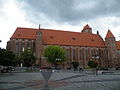
The main landmark is the [[Kwidzyn Castle]], a 14th-century [[Brick Gothic]] [[Ordensburg]] castle and cathedral complex of the Pomesanian Cathedral Chapter, which now houses a museum. It is listed as a [[List of Historic Monuments (Poland)|Historic Monument of Poland]].<ref>{{Cite Polish law|title=Rozporządzenie Prezydenta Rzeczypospolitej Polskiej z dnia 20 kwietnia 2018 r. w sprawie uznania za pomnik historii "Kwidzyn - zespół katedralno-zamkowy"|year=2018|number=930}}</ref> The adjacent co-cathedral of St. John the Evangelist was built between 1343 and 1384, and serves as a co-cathedral of the [[Roman Catholic Diocese of Elbląg]]. It contains the tombs of three [[Grand Master (order)|Grand Masters]] of the Teutonic Knights as well as numerous bishops. A bridge connects the castle to a sewer tower which was once situated on a river that has since dried up. |
||
Other sights include the Appellate Court for Kwidzyn County, the town hall, the Holy Trinity church, the Saint Padre Pio chapel, various government buildings and old townhouses. |
Other sights include the Appellate Court for Kwidzyn County, the town hall, the Holy Trinity church, the Saint Padre Pio chapel, various government buildings and old townhouses. |
||
| Line 140: | Line 113: | ||
==Transport== |
==Transport== |
||
[[File:Dworzec Kolejowy na ul. Kościuszki 54 w Kwidzynie.jpg|thumb|Train station]] |
|||
The intersections of Polish [[National roads in Poland|National roads]] 55 and 90, [[Voivodeship road]]s 521 and 532, and Voivodeship roads 518 and 588, are located either in Kwidzyn or just outside of the town limits. There is also a train station. |
The intersections of Polish [[National roads in Poland|National roads]] 55 and 90, [[Voivodeship road]]s 521 and 532, and Voivodeship roads 518 and 588, are located either in Kwidzyn or just outside of the town limits. There is also a train station. |
||
| Line 154: | Line 128: | ||
* [[Rudolf Heidenhain]] (1834–1897), German physiologist |
* [[Rudolf Heidenhain]] (1834–1897), German physiologist |
||
* [[Gustav Cohn]] (1840–1919), German economist, particularly re. public finance |
* [[Gustav Cohn]] (1840–1919), German economist, particularly re. public finance |
||
* [[Elard von Oldenburg-Januschau]] (1855-1937 in Marienwerder), German Junker and conservative politician. |
|||
* [[Kurt Rosenfeld]] (1877–1943), lawyer and politician |
* [[Kurt Rosenfeld]] (1877–1943), lawyer and politician |
||
* [[Józef Krasnowolski]] (1879–1939), Polish painter |
* [[Józef Krasnowolski]] (1879–1939), Polish painter |
||
* [[Fritz Goerdeler]] (1886–1945), German jurist and resistance fighter; mayor |
* [[Fritz Goerdeler]] (1886–1945), German jurist and resistance fighter; mayor 1920–33 |
||
* [[Joachim Witthöft]] (1887–1966), general |
* [[Joachim Witthöft]] (1887–1966), general |
||
* [[Kurt-Jürgen Freiherr von Lützow]] (1892–1961), general |
* [[Kurt-Jürgen Freiherr von Lützow]] (1892–1961), general |
||
| Line 164: | Line 137: | ||
* [[Ernst Tillich]] (1910–1985), German theologian |
* [[Ernst Tillich]] (1910–1985), German theologian |
||
* Bernard Friese (1927–2010), co-founder of [[Gilbern]] cars |
* Bernard Friese (1927–2010), co-founder of [[Gilbern]] cars |
||
* [[Hardy Rodenstock]] ( |
* [[Hardy Rodenstock]] (1941–2018), music publisher and manager; dealer in old and rare wine |
||
* {{ |
* {{interlanguage link|Maciej Aksler|pl}} (1947–2006), Polish test pilot |
||
* [[Wiesław Hartman]] ( |
* [[Wiesław Hartman]] (1950–2021), Polish show jumping equestrian, silver medallist in the [[1980 Summer Olympics]] |
||
* [[Wojciech Belon]] (1952–1985), Polish poet, songwriter and folksinger |
* [[Wojciech Belon]] (1952–1985), Polish poet, songwriter and folksinger |
||
* [[Izabela Tomaszewska]] (1955–2010), Polish government official and archeologist |
* [[Izabela Tomaszewska]] (1955–2010), Polish government official and archeologist |
||
| Line 174: | Line 147: | ||
* [[Maciej Silski]] (born 1976), Polish singer |
* [[Maciej Silski]] (born 1976), Polish singer |
||
* [[Patryk Rombel]] (born 1983), Polish handball coach, currently coaching the [[Poland national handball team|Polish national team]] |
* [[Patryk Rombel]] (born 1983), Polish handball coach, currently coaching the [[Poland national handball team|Polish national team]] |
||
==Burials== |
|||
* [[Werner von Orseln]] (c.1280–1330) the 17th Grand Master of the Teutonic Order |
|||
* [[Otto Friedrich von der Groeben]] (1657–1728) a Prussian explorer, officer and German Generalleutnant in Polish service |
|||
==Gallery== |
==Gallery== |
||
| Line 183: | Line 152: | ||
File:Kwidzyn, katedra, ob. kościół p.w. św. Jana Ewangelisty.jpg|Kwidzyn Cathedral |
File:Kwidzyn, katedra, ob. kościół p.w. św. Jana Ewangelisty.jpg|Kwidzyn Cathedral |
||
File:SM Kwidzyn Sąd Rejonowy (0) ID 636613.jpg|District court |
File:SM Kwidzyn Sąd Rejonowy (0) ID 636613.jpg|District court |
||
File:SM Kwidzyn Braterstwa Narodów 50 Poczta (0) ID 636564.jpg| |
File:SM Kwidzyn Braterstwa Narodów 50 Poczta (0) ID 636564.jpg|Main post office |
||
File:Kwidzyn, Powiślańska Szkoła Wyższa - panoramio.jpg|Powiślańska Szkoła Wyższa (''Powiśle College'') |
File:Kwidzyn, Powiślańska Szkoła Wyższa - panoramio.jpg|Powiślańska Szkoła Wyższa (''Powiśle College'') |
||
File:Budynek Sztabowy Koszar Wojskowych w Kwidzynie - widok od tyłu.jpg|Neo-gothic complex of barracks, 19th century |
File:Budynek Sztabowy Koszar Wojskowych w Kwidzynie - widok od tyłu.jpg|Neo-gothic complex of barracks, 19th century |
||
| Line 189: | Line 158: | ||
File:Kwidzyn-kosciol-sw-Trojcy.jpg|Holy Trinity church |
File:Kwidzyn-kosciol-sw-Trojcy.jpg|Holy Trinity church |
||
File:Kwidzyn, Urząd Finansowy, ob. biblioteka, kon. XIX.JPG|Library and a monument of [[Józef Piłsudski]] |
File:Kwidzyn, Urząd Finansowy, ob. biblioteka, kon. XIX.JPG|Library and a monument of [[Józef Piłsudski]] |
||
File:Dworzec Kolejowy na ul. Kościuszki 54 w Kwidzynie.jpg|Train station |
|||
File:Kwidzyn, dawny szpital św. Jerzego.jpg|Former Saint George hospital |
File:Kwidzyn, dawny szpital św. Jerzego.jpg|Former Saint George hospital |
||
File:Kwidzyn palac Fermora 07.jpg|Vocational school |
File:Kwidzyn palac Fermora 07.jpg|Vocational school |
||
File:Kwidzyn, kino Tęcza - panoramio.jpg|Former casino and cinema building |
File:Kwidzyn, kino Tęcza - panoramio.jpg|Former casino and cinema building |
||
File:Przedszkole Miejskie nr 1 w Kwidzynie.jpg|Municipal Preschool No. 1 |
|||
</gallery> |
</gallery> |
||
| Line 214: | Line 183: | ||
==Sources== |
==Sources== |
||
*{{cite book |last=Neuman |first=Franz |last2=Gründer |first2=Otto |title=Marienwerder Westpreußen: Aus den Leben einer deutschen Stadt an der unteren Weichsel |publisher=Heimatkreis Marienwerder/Westpreußen |date=1983 |pages=315–316}} |
|||
*[[Stephen Turnbull (historian)|Stephen Turnbull]]: ''Crusader Castles of the Teutonic Knights: The Red-Brick Castles of Prussia 1230-1466'', October 2003 ([https://web.archive.org/web/20071021054408/http://www.ospreypublishing.com/title_detail.php/title=S5570~ser=FOR eBook, PDF]) |
|||
==External links== |
==External links== |
||
| Line 220: | Line 189: | ||
*[http://www.kwidzyn.pl/ Municipal website] {{in lang|pl}} |
*[http://www.kwidzyn.pl/ Municipal website] {{in lang|pl}} |
||
*[https://web.archive.org/web/20060626162159/http://www.wsz.kwidzyn.edu.pl/english.htm Kwidzyn School of Management] |
*[https://web.archive.org/web/20060626162159/http://www.wsz.kwidzyn.edu.pl/english.htm Kwidzyn School of Management] |
||
*[http://www.kwidzyn.com/english.html Kwidzyn City Portal] {{in lang|en}} |
*[http://www.kwidzyn.com/english.html Kwidzyn City Portal] {{Webarchive|url=https://web.archive.org/web/20090801145524/http://www.kwidzyn.com/english.html |date=2009-08-01 }} {{in lang|en}} |
||
{{Kwidzyn County}} |
{{Kwidzyn County}} |
||
Revision as of 23:28, 13 June 2024
Kwidzyn | |
|---|---|
  .jpg)   Clockwise from top:
| |
 Flag  Coat of arms | |
 | |
 Kwidzyn | |
| Coordinates: 53°44′9″N 18°55′51″E / 53.73583°N 18.93083°E | |
| Land | |
| Voivodeship | |
| County | Kwidzyn |
| Gmina | Kwidzyn (urban gmina) |
| Established | 11th century |
| Town rights | 1233 |
| Regierung | |
| • Mayor | Andrzej Krzysztof Krzysztofiak |
| Area | |
| • Total | 21.82 km2 (8.42 sq mi) |
| Elevation | 42 m (138 ft) |
| Population (2021) | |
| • Total | 37,975[1] |
| Time zone | UTC+1 (CET) |
| • Summer (DST) | UTC+2 (CEST) |
| Postal code | 82-500 |
| Area code | +48 55 |
| Vehicle registration | GKW |
| National roads | |
| Voivodeship roads | |
| Website | https://www.kwidzyn.pl |
Kwidzyn (Kfee-dzin [ˈkfʲid͡zɨn]; German: Marienwerder; Latin: Quedin; Old Prussian: Kwēdina) is a town in northern Poland on the Liwa River. With a population of 37,975, it is the capital of Kwidzyn County in the Pomeranian Voivodeship.[1]
Geography
Kwidzyn is located on the Liwa River, some 5 kilometres (3.1 miles)[2] east of the Vistula river, approximately 70 km (43 mi) south of Gdańsk and 145 km (90 mi) southwest of Kaliningrad. It is part of the region of Powiśle.
History

The Pomesanian settlement called Kwedis existed in the 11th century. In 1232, the Teutonic Knights built the castle and established the town of Marienwerder (now Kwidzyn) the following year. In 1243, the Bishopric of Pomesania received both the town and castle from the Teutonic Order as fiefs, and the settlement became the seat of the Bishops of Pomesania within Prussia.[3] The town was populated by artisans and traders, originating from towns in the northern parts of the Holy Roman Empire. A Teutonic knight, Werner von Orseln, was murdered in Marienburg (Malbork) in 1330. He was among the first to be buried in the newly erected cathedral of the town.
St. Dorothea of Montau lived in Marienwerder from 1391 until her death in 1394; future pilgrims visiting her shrine would contribute to the flourishing economy.
The Prussian Confederation, which opposed Teutonic rule, was founded in the town on March 14, 1440.[4] The town itself joined the organization on 17 April 1440.[5] Upon the request of the organization in 1454 Polish King Casimir IV Jagiellon incorporated the region and town to the Kingdom of Poland,[6] and the Thirteen Years' War broke out. In 1466, after the defeat of the Teutonic Knights in the war, the town became part of Poland as a fief held by the Teutonic Knights.[7] In 1525, the Teutonic state was transformed into a secular and Lutheran duchy under the last Grand Master of the Teutonic Order Albert, a political foundation only possible with the consent of the Polish King Sigismund I the Old. The town was visited by Polish Kings Sigismund II Augustus in 1552[8] and Stephen Báthory in 1576.[9] In 1618 the ducal rights were inherited by the Brandenburg branch of the House of Hohenzollern, remaining under Polish suzerainty. In 1657 the Brandenburg dukes severed ties with the Polish crown and in 1701 elevated their realm to the sovereign Kingdom of Prussia. During the War of the Polish Succession, Polish King Stanisław Leszczyński stayed in the town in July 1734.[10]
The town of Marienwerder meanwhile had become the capital of the District of Marienwerder. In 1772, the Marienwerder district was integrated into the newly established Prussian Province of West Prussia, which consisted mostly of territories annexed in the First Partition of Poland. In November 1831, several Polish cavalry units of the November Uprising stopped in the town on the way to their internment places.[11]
.jpg)
By the enlargement of its administrative functions, the population of the town started to grow and in 1885, it numbered 8,079. This population was composed mostly of Lutheran inhabitants, many of whom were engaged in trades connected with the manufacturing of sugar, vinegar and brewing as well as dairy farming, fruit growing and the industrial construction of machines. In 1910, Marienwerder had a population of 12,983 of which 12,408 (95.6%) were German-speaking and 346 (2.7%) were Polish-speaking.[12]
As a result of the Treaty of Versailles after World War I, the district of Marienwerder was divided. The parts west of the Vistula were incorporated into the Polish Second Republic, which had just regained its independence. The parts east of the Vistula, to which the town of Marienwerder belonged, was to take part in the East Prussian plebiscite, which was organized under the control of the League of Nations. The Inter-Allied Commission with nearly 2,000 troops often favored the Germans, and its services towards Poles were often delayed and limited, while the administration remained under German control.[13] The town was home to the Polish Warmian Plebiscite Committee and the Committee for Polish Affairs, which, however, had to operate partly secretly.[14] On May 16, 1920, the largest Polish plebiscite demonstration in Powiśle took place in the town, and Poles had to organize defenses against attacks by German militias.[15] According to Polish sources there was German electoral fraud[16] resulted in 7,811 votes given to remain in East Prussia, and therefore Germany, and only 362 for Poland.[17] Afterwards, anti-Polish terror intensified.[16]
.jpg)
According to the Geneva Conventions, the Polish community was entitled to its own schools, and from 1934 local Poles strove to establish a Polish school.[18] The Germans blocked the establishment of the school, and Polish organizations filed 100 complaints to the German administration before the Polish private gymnasium was finally established on November 10, 1937.[18] Local German press incited the Germans against the Polish school,[19] and in 1938 a fourteen-year-old boy was shot at the school playground, which the German police ignored, and the shooter was not caught.[18] The Germans, especially the Hitler Youth, repeatedly harassed and attacked Polish students and devastated the school.[18] It was forcibly closed down on August 25, 1939.[20] The German police surrounded the Polish school and arrested its principal Władysław Gębik, 13 teachers, other staff and 162 students, who were imprisoned in Tapiau (today Gvardeysk),[21] and then deported elsewhere. Later on, students under the age of 18 were released, older students were forcibly conscripted into the Wehrmacht, while teachers and staff were deported to concentration camps,[18] where most of them were murdered.[22] The head of the local Polish Bank Ludowy was also arrested, and the local Polish consulate was cut off from telephone lines, nevertheless the state radio in Poland still provided information regarding the attack on the Polish school on the same day.[21]
Nazi Germany co-formed the Einsatzgruppe V in the town, which then entered several Polish cities, including Grudziądz, Ciechanów, Łomża and Siedlce, to commit various atrocities against Poles during the German invasion of Poland, which started World War II.[23] Many Poles expelled from German-occupied Poland were deported to forced labour in the town's vicinity.[24] The Germans also operated a subcamp of the Stutthof concentration camp in the town.[25] On 21 January at approximately 16:00, a surprising order came to evacuvate the civilians westwards towards Chojnice. When the Red Army invaded East Prussia at least 95% of the citizens of Marienwerder were speaking German as their mother tongue, and therefore they feared the atrocities committed to the German population. A majority of them left the city but not all arrived save territory alive. Those which stayed were robbed, raped and eventually murdered by the Red Army. On 30 January the town was captured by the Red Army. The Red Army established a war hospital in the town for 20,000 people. The town center was burned and pillaged by Soviet soldiers. In the course of 1945 the city was emptied of the last German inhabitants. Meanwhile, large parts of the inner city were sacked. Since then, Polish newcomers from Poland and Lithuania repopulated the town and its environments. The Lutheran ecclesiastical buildings were handed over to the Catholic Church.[26] After World War II, the town became again part of Poland under the terms of the Potsdam Agreement, although with a Soviet-installed communist regime, which stayed in power until the 1980s. From 1975 to 1998, it was administratively located in the Elbląg Voivodeship.

In 1982, the communists brutally crushed the protest of interned anti-communist oppositionists.[27]
Demographics
|
|
| ||||||||||||||||||||||||||||||||||||||||||||||||||||||||||||||||||
| The above table is based on biased primary sources from the time of Prussian Partition of Poland.[3][28][29][2][30][31][32] | ||||||||||||||||||||||||||||||||||||||||||||||||||||||||||||||||||||
Points of interest
The main landmark is the Kwidzyn Castle, a 14th-century Brick Gothic Ordensburg castle and cathedral complex of the Pomesanian Cathedral Chapter, which now houses a museum. It is listed as a Historic Monument of Poland.[33] The adjacent co-cathedral of St. John the Evangelist was built between 1343 and 1384, and serves as a co-cathedral of the Roman Catholic Diocese of Elbląg. It contains the tombs of three Grand Masters of the Teutonic Knights as well as numerous bishops. A bridge connects the castle to a sewer tower which was once situated on a river that has since dried up.
Other sights include the Appellate Court for Kwidzyn County, the town hall, the Holy Trinity church, the Saint Padre Pio chapel, various government buildings and old townhouses.
Economy
A branch of International Paper is located in Kwidzyn, as is the Kwidzyn School of Management.
The second biggest employer in Kwidzyn is Jabil, a global electronics manufacturing services company.[34]
The city has lower average crime and unemployment rates when compared with the national average rates of Poland.[34] These lower rates are attributed to sports programmes for youth such as MMTS Kwidzyn (handball) and MTS Basket Kwidzyn.[34]
Sports
The town's main sports clubs are:
- MMTS Kwidzyn, handball club which plays in the Polish Superliga (top division; as of 2022), runners-up in season 2009–10
- Basket Kwidzyn, basketball club which plays in the lower leagues, but played in the Polish Basketball League (top division) in the past
- Rodło Kwidzyn, football club which plays in the lower leagues
Transport

The intersections of Polish National roads 55 and 90, Voivodeship roads 521 and 532, and Voivodeship roads 518 and 588, are located either in Kwidzyn or just outside of the town limits. There is also a train station.
Notable people
- Dorothea of Montau (1347–1394), hermitess and visionary of 14th century Germany, canonized in 1976.
- Paul Speratus (1484–1551), Catholic priest who became a Protestant preacher, reformer and hymn-writer
- Eduard Heinrich von Flottwell (1786–1865), Prussian Staatsminister and Regierungspräsident of Marienwerder in 1825
- Hans Adolf Erdmann von Auerswald (1792–1848), Prussian general and politician
- Karl Ludwig Hencke (1793–1866 in Marienwerder), amateur astronomer and discoverer of minor planets
- Rudolf von Auerswald (1795–1866), Prime Minister of Prussia
- Carl Julius Meyer von Klinggräff (1809–1879), German botanist
- Hermann von Dechend (1814–1890), first President of the Reichsbank
- Heinrich Julian Schmidt (1818–1886), German journalist and historian of literature [35]
- Rudolf Heidenhain (1834–1897), German physiologist
- Gustav Cohn (1840–1919), German economist, particularly re. public finance
- Kurt Rosenfeld (1877–1943), lawyer and politician
- Józef Krasnowolski (1879–1939), Polish painter
- Fritz Goerdeler (1886–1945), German jurist and resistance fighter; mayor 1920–33
- Joachim Witthöft (1887–1966), general
- Kurt-Jürgen Freiherr von Lützow (1892–1961), general
- Ida Siekmann (1902–1961) nurse, first victim of Berlin Wall
- Ernst Schiffner (1903–1980), German actor and director
- Ernst Tillich (1910–1985), German theologian
- Bernard Friese (1927–2010), co-founder of Gilbern cars
- Hardy Rodenstock (1941–2018), music publisher and manager; dealer in old and rare wine
- Maciej Aksler (1947–2006), Polish test pilot
- Wiesław Hartman (1950–2021), Polish show jumping equestrian, silver medallist in the 1980 Summer Olympics
- Wojciech Belon (1952–1985), Polish poet, songwriter and folksinger
- Izabela Tomaszewska (1955–2010), Polish government official and archeologist
- Tomasz Piotr Nowak (born 1956), Polish politician
- Jacek Borcuch (born 1970), Polish actor and film director
- Marek Szulen (born 1975), Polish composer of electronic music, lives in the Netherlands
- Maciej Silski (born 1976), Polish singer
- Patryk Rombel (born 1983), Polish handball coach, currently coaching the Polish national team
Gallery
-
 Kwidzyn Cathedral
 -
 District court
 -
 Main post office
 -
 Powiślańska Szkoła Wyższa (Powiśle College)
 -
 Neo-gothic complex of barracks, 19th century
 -
 Saint Padre Pio chapel
 -
 Holy Trinity church
 -
 Library and a monument of Józef Piłsudski
 -
 Former Saint George hospital
 -
 Vocational school
 -
 Former casino and cinema building
 -
 Municipal Preschool No. 1

_ID_636613.jpg)
_ID_636564.jpg)


International relations
Kwidzyn is twinned with:
References
- ^ a b "Kwidzyn (pomorskie) w liczbach » Przystępne dane statystyczne". Polska w liczbach.
- ^ a b Meyers Großes Konversations-Lexikon. Vol. 13 (6th ed.). Leipzig and Vienna: Bibliographisches Institut. 1908. p. 299.
- ^ a b August Eduard Preuß: Preußische Landes- und Volkskunde. Königsberg 1835, pp. 441–444.
- ^ Jürgen Sarnowsky: Der Deutsche Orden. Beck, Munich 2007, ISBN 978-3-406-53628-1, p. 100 ff. (restricted preview).
- ^ Górski, Karol (1949). Związek Pruski i poddanie się Prus Polsce: zbiór tekstów źródłowych (in Polish). Poznań: Instytut Zachodni. p. XXXVII.
- ^ Górski, p. 54
- ^ Górski, p. 96-97, 214-215
- ^ Moraczewski, Jędrzej (1847). Dzieje Rzeczypospolitej Polskiej z pierwszéj połowy szesnastego wieku (in Polish). Poznań. p. 277.
- ^ Gołębiowski, Łukasz (1830). Domy i dwory (in Polish). Warszawa. p. 87.
- ^ Ciesielski, Tomasz (2010). "Prusy Wschodnie w trakcie polskiej wojny sukcesyjnej i wojny siedmioletniej". In Gieszczyński, Witold; Kasparek, Norbert (eds.). Wielkie wojny w Prusach. Działania militarne między dolną Wisłą a Niemnem na przestrzeni wieków (in Polish). Dąbrówno. p. 107. ISBN 978-83-62552-00-9.
{{cite book}}: CS1 maint: location missing publisher (link) - ^ Kasparek, Norbert (2014). "Żołnierze polscy w Prusach po upadku powstania listopadowego. Powroty do kraju i wyjazdy na emigrację". In Katafiasz, Tomasz (ed.). Na tułaczym szlaku... Powstańcy Listopadowi na Pomorzu (in Polish). Koszalin: Muzeum w Koszalinie, Archiwum Państwowe w Koszalinie. p. 140.
- ^ Landesamt, Prussia (Kingdom) Statistisches (1912). Gemeindelexikon für die regierungsbezirke Allenstein, Danzig, Marienwerder, Posen, Bromberg und Oppeln: Auf grund der ergebnisse der volkszählung vom. 1. Dezember 1910 und anderer amtlicher quellen bearbeitet vom Königlich Preussischen Statistischen Landesamte (in German). verlag des Königlichen Statistischen Landesamts.
- ^ Plebiscyt 1920 roku. Walka o Polskość Warmii, Mazur i Powiśla (in Polish). IPN. p. 15.
- ^ Plebiscyt 1920 roku. Walka o Polskość Warmii, Mazur i Powiśla, pp. 16–17
- ^ Plebiscyt 1920 roku. Walka o Polskość Warmii, Mazur i Powiśla, p. 17
- ^ a b Plebiscyt 1920 roku. Walka o Polskość Warmii, Mazur i Powiśla, p. 18
- ^ Marzian, Herbert; Kenez, Csaba (1970). Selbstbestimmung für Ostdeutschland – Eine Dokumentation zum 50 Jahrestag der ost- und westpreussischen Volksabstimmung am 11. Juli 1920 (in German). p. 117.
- ^ a b c d e Justyna Liguz. "Rzeczypospolita Kwidzyńska - dzieje Polskiego Gimnazjum w Prusach Wschodnich". Interia Nowa Historia (in Polish). Retrieved 20 September 2020.
- ^ Wardzyńska, Maria (2009). Był rok 1939. Operacja niemieckiej policji bezpieczeństwa w Polsce. Intelligenzaktion (in Polish). Warszawa: IPN. p. 31.
- ^ Andreas Lawaty, Wiesław Mincer and Anna Domańska: Deutsch-polnische Beziehungen in Geschichte und Gegenwart – Bibliographie. Vol 2: Religion, Buch, Presse, Wissenschaft, Bildung, Philosophie, Harrassowitz, Wiesbaden, ISBN 3-447-04243-5, p. 879 (restricted preview)
- ^ a b Cygański, Mirosław (1984). "Hitlerowskie prześladowania przywódców i aktywu Związków Polaków w Niemczech w latach 1939-1945". Przegląd Zachodni (in Polish) (4): 41.
- ^ Cygański, p. 43
- ^ Wardzyńska (2009), p. 54
- ^ Wardzyńska, Maria (2017). Wysiedlenia ludności polskiej z okupowanych ziem polskich włączonych do III Rzeszy w latach 1939-1945 (in Polish). Warszawa: IPN. pp. 119, 129. ISBN 978-83-8098-174-4.
- ^ "Marienwerder" (in German). Retrieved 20 September 2020.
- ^ Neuman & Gründer 1983, pp. 315–316.
- ^ "Polewanie woda, bicie pałkami, kopanie i szczucie psami. 40 lat temu krwaro stłumiono protest w Kwidzynie". Polska Agencja Prasowa. 14 August 2022. Retrieved 16 October 2022.
- ^ Michael Rademacher: Deutsche Verwaltungsgeschichte Provinz Westpreußen, Kreis Marienwerder (2006)
- ^ Der Große Brockhaus. Vol. 12 (15th ed.). Leipzig: F. A. Brockhaus AG. 1932. p. 143.
- ^ Johann Friedrich Goldbeck: Vollständige Topographie des Königreichs Preußen. Teil II, Marienwerder 1789, pp. 3–6.
- ^ Dokumentacja Geograficzna (in Polish). Vol. 3/4. Warszawa: Instytut Geografii Polskiej Akademii Nauk. 1967. p. 25.
- ^ Stan i struktura ludności oraz ruch naturalny w przekroju terytorialnym w 2010 r. (PDF) (in Polish). Warszawa: Główny Urząd Statystyczny. 2011. p. 90. Archived from the original (PDF) on 13 November 2011.
- ^ Rozporządzenie Prezydenta Rzeczypospolitej Polskiej z dnia 20 kwietnia 2018 r. w sprawie uznania za pomnik historii "Kwidzyn - zespół katedralno-zamkowy", Dz. U., 2018, No. 930
- ^ a b c Turystyka, historia, zabytki. Kwidzyn Moje miasto.
- ^ . Encyclopædia Britannica. Vol. 24 (11th ed.). 1911.
- ^ "Stadt Celle". www.celle.de. Retrieved 2010-01-05.
Sources
- Neuman, Franz; Gründer, Otto (1983). Marienwerder Westpreußen: Aus den Leben einer deutschen Stadt an der unteren Weichsel. Heimatkreis Marienwerder/Westpreußen. pp. 315–316.
External links
- Municipal website (in Polish)
- Kwidzyn School of Management
- Kwidzyn City Portal Archived 2009-08-01 at the Wayback Machine (in English)
| Seat |
|  |
|---|---|---|
| Urban-rural gmina | ||
| Rural gminas | ||

| International | |
|---|---|
| National | |
| Geographic | |