
List of mountains in Oman: Difference between revisions
m v2.05b - Bot T5 CW#16 - Fix errors for CW project (Unicode control characters) |
LukasSimeone (talk | contribs) No edit summary |
||
| (11 intermediate revisions by 4 users not shown) | |||
| Line 1: | Line 1: | ||
{{Short description|none}} |
|||
[[File:Oman location map Topographic.png|left|thumb|Oman topographic map]] |
[[File:Oman location map Topographic.png|left|thumb|Oman topographic map]] |
||
[[File:Jebel Shams (2).jpg|thumb|Oman - [[Jebel Shams]] Grand Canyon]] |
[[File:Jebel Shams (2).jpg|thumb|Oman - [[Jebel Shams]] Grand Canyon]] |
||
| Line 8: | Line 9: | ||
Although much of the country has a [[desert]] or semi-desert and relatively flat territory, [[Oman]] has mountains that include the [[Hajar Mountains]] (''{{lang-ar|جبال الحجر }}''), located in the northeast of Oman and the far northeast of the [[United Arab Emirates]]. These mountains constitute the tallest [[mountain range]] in the eastern part of the [[Arabia|Arabian Peninsula]]. |
Although much of the country has a [[desert]] or semi-desert and relatively flat territory, [[Oman]] has mountains that include the [[Hajar Mountains]] (''{{lang-ar|جبال الحجر }}''), located in the northeast of Oman and the far northeast of the [[United Arab Emirates]]. These mountains constitute the tallest [[mountain range]] in the eastern part of the [[Arabia|Arabian Peninsula]]. |
||
The highest peaks are found in the [[Jebel Akhdar (Oman)|Jebel Akhdar Mountains]] (in Arabic: الجبل الأخض), mountain massif approximately {{Convert|80|km|mi|abbr=on}} long and {{Convert|32|km|mi|abbr=on}} wide, belonging to the Hajar Mountains,<ref>https://www.agda.ae/en/catalogue/tna/air/5/1284/n/39 Persian Gulf and Arabian Coast: mountains or mounds - Ref. AIR 5/1284 - PAGE 39 - The National Archives, London, England</ref> which covers an area of {{Convert|1,135|km2|mi2|abbr=on}} located above {{Convert|1,500|m|ft|abbr=on}}, of which, {{Convert|410|km2|mi2|abbr=on}} are located above {{Convert|2,000|m|ft|abbr=on}}, and {{Convert|30|km2|mi2|abbr=on}} are above {{Convert|2,500|m|ft|abbr=on}}.<ref name="tribulus"> Tribulus - Volume 19 - 2011 - Journal of the Emirates Natural History Group - The Flora of the Ru'us al-Jibal -the Mountains of the Musandam Peninsula: An Annotated Checklist and Selected Observations - Gary R. Feulner - Abu Dhabi, United Arab Emirates, 2011<https://enhg.org/Portals/1/trib/V19/TribulusV19.pdf></ref> |
|||
Some of the highest peaks in [[Oman]] are located on the border with [[United Arab Emirates]], since in some cases, their position was taken as a reference for the drawing of the border limits between both countries. <ref name="border">{{cite web |publisher=Arabian Gulf Digital Archives |title=FO 371/132797 - Frontiers between Muscat and Trucial States- 1958 - The National Archives, London, England |url=https://www.agda.ae/en/catalogue/tna/fo/371/132797/n/106 |access-date=2023-05-13}} </ref> |
|||
On the other hand, some of the most relevant peaks, although of lower altitude, are located on the border between Oman and the United Arab Emirates, since in some cases, their position was taken as a reference for the defining the border between the two countries.<ref name="border">{{cite web |publisher=Arabian Gulf Digital Archives |title=FO 371/132797 - Frontiers between Muscat and Trucial States- 1958 - The National Archives, London, England |url=https://www.agda.ae/en/catalogue/tna/fo/371/132797/n/106 |access-date=2023-05-13}} </ref> |
|||
However, although a boundary agreement was signed and ratified in 2003, covering the entire border between Oman and the United Arab Emirates, including Oman's enclaves on the [[Musandam Peninsula]] and in [[Mahdah]], the contents of the agreement have not yet been published, nor detailed maps showing the alignment,<ref>{{cite web |publisher=CIA.gov |title=The World Factbook |url=https://www.cia.gov/the-world-factbook/field/disputes-international |access-date=2023-05-08}}</ref> despite the fact that some border markers and fences have already been placed on the ground. The future publication of these agreements and maps could make it necessary to modify the content of this annex. |
|||
This list includes the name and location of the summits located entirely within the territory of Oman, or at least with its summit located on the border line, regardless of its height. The list is open to new additions referring to mountains that meet these conditions, with a known name and position, and whose reference data is supported by historical maps or other reliable documentary sources. |
This list includes the name and location of the summits located entirely within the territory of Oman, or at least with its summit located on the border line, regardless of its height. The list is open to new additions referring to mountains that meet these conditions, with a known name and position, and whose reference data is supported by historical maps or other reliable documentary sources. |
||
| Line 39: | Line 42: | ||
|-valign= top |
|-valign= top |
||
| bgcolor=#D8D8D8 |[[Jebel Shams]]|| {{refn|group=lower-alpha|Alternative Names: Jabal ash Shām, Jabal Sham, Wishām, Jabal Shams, Jabal ash Sham, Wisham, جبل شمس }}<ref>https://www.agda.ae/en/catalogue/tna/air/5/1284/n/55 Persian Gulf and Arabian Coast: mountains or mounds - Ref. AIR 5/1284 - PAGE 55 - The National Archives, London, England</ref><ref>[https://om.geoview.info/jabal_shams,286476 www.geoview.info - Jabal Shams]</ref><ref>https://www.peakbagger.com/peak.aspx?pid=13231 www.peakbagger.com - Jebel Shams, Oman</ref><ref>Trekking path to the southern summit of Jabal Shams from ‘The Plateau’ - Ministry of Tourism <https://web.archive.org/web/20130309194328/http://www.omantourism.gov.om/wps/wcm/connect/ac5623804470a00db4dabfbf0c53e49e/trekking+routs3.pdf?MOD=AJPERES&CONVERT_TO=url&CACHEID=ac5623804470a00db4dabfbf0c53e49e] |
| bgcolor=#D8D8D8 |[[Jebel Shams]]|| {{refn|group=lower-alpha|Alternative Names: Jabal ash Shām, Jabal Sham, Wishām, Jabal Shams, Jabal ash Sham, Wisham, جبل شمس }}<ref name="tribulus"/><ref>https://www.agda.ae/en/catalogue/tna/air/5/1284/n/55 Persian Gulf and Arabian Coast: mountains or mounds - Ref. AIR 5/1284 - PAGE 55 - The National Archives, London, England</ref><ref>[https://om.geoview.info/jabal_shams,286476 www.geoview.info - Jabal Shams]</ref><ref>https://www.peakbagger.com/peak.aspx?pid=13231 www.peakbagger.com - Jebel Shams, Oman</ref><ref>Trekking path to the southern summit of Jabal Shams from ‘The Plateau’ - Ministry of Tourism <https://web.archive.org/web/20130309194328/http://www.omantourism.gov.om/wps/wcm/connect/ac5623804470a00db4dabfbf0c53e49e/trekking+routs3.pdf?MOD=AJPERES&CONVERT_TO=url&CACHEID=ac5623804470a00db4dabfbf0c53e49e]</ref><ref>https://www.agda.ae/en/catalogue/tna/air/5/1284/n/55 Persian Gulf and Arabian Coast: mountains or mounds - Ref. AIR 5/1284 - 1936 - The National Archives, London, England</ref>|| 001|| [[Hajar Mountains]] || {{OMA}} || [[Ad Dakhiliyah Governorate|Ad Dakhiliyah]] || align=right| {{formatnum:3018}} || {{coord|23|14|15.00|N|57|15|49.66|E|name=Jebel Shams}} |
||
|-valign= top |
|-valign= top |
||
| Line 95: | Line 98: | ||
|-valign= top |
|-valign= top |
||
| bgcolor=#D8D8D8 | Jabal as Sayh || {{refn|group=lower-alpha|Alternative Names: Jabal as Sayh, Jabal as Sayḩ.}}<ref>{{cite web |publisher=Mindat.org |title=Mindat - Jabal as Sayḩ |url=https://www.mindat.org/feature-390047.html |access-date=2023-05-08}}</ref>|| 019 || [[Hajar Mountains]] || {{OMA}}<br />{{UAE}} ||[[Musandam Governorate|Musandam]]<br /><br />{{ |
| bgcolor=#D8D8D8 | Jabal as Sayh || {{refn|group=lower-alpha|Alternative Names: Jabal as Sayh, Jabal as Sayḩ.}}<ref>{{cite web |publisher=Mindat.org |title=Mindat - Jabal as Sayḩ |url=https://www.mindat.org/feature-390047.html |access-date=2023-05-08}}</ref>|| 019 || [[Hajar Mountains]] || {{OMA}}<br />{{UAE}} ||[[Musandam Governorate|Musandam]]<br /><br />{{flagcountry|Ras al-Khaimah}}|| align=right| {{formatnum:1746}} || {{coord|25|58|18.8|N|56|11|30|E|name=Jabal as Sayh}} |
||
|-valign= top |
|-valign= top |
||
| Line 101: | Line 104: | ||
|-valign= top |
|-valign= top |
||
| bgcolor=#D8D8D8 | Jabal Hadaba || {{refn|group=lower-alpha|Alternative Names: Jebel Hadaba.}}<ref name="mapBoundaries">FCO 18/1920 - 1962 - Boundaries of the Northern Trucial States: prepared and drawn from sketch maps and information supplied by Julian Walker; preliminary edition<https://www.agda.ae/en/catalogue/tna/fco/18/1920></ref><ref name="mapSketch">FCO 18/1932 - 1958 - Sketch map drawn by Julian Walker for boundary delimitation: Ras Al Khaimah<https://www.agda.ae/en/catalogue/tna/fco/18/1932></ref>|| 021 || [[Hajar Mountains]] || {{OMA}}<br />{{UAE}} ||[[Musandam Governorate|Musandam]]<br /><br />{{ |
| bgcolor=#D8D8D8 | Jabal Hadaba || {{refn|group=lower-alpha|Alternative Names: Jebel Hadaba.}}<ref name="mapBoundaries">FCO 18/1920 - 1962 - Boundaries of the Northern Trucial States: prepared and drawn from sketch maps and information supplied by Julian Walker; preliminary edition<https://www.agda.ae/en/catalogue/tna/fco/18/1920></ref><ref name="mapSketch">FCO 18/1932 - 1958 - Sketch map drawn by Julian Walker for boundary delimitation: Ras Al Khaimah<https://www.agda.ae/en/catalogue/tna/fco/18/1932></ref>|| 021 || [[Hajar Mountains]] || {{OMA}}<br />{{UAE}} ||[[Musandam Governorate|Musandam]]<br /><br />{{flagcountry|Ras al-Khaimah}}|| align=right| {{formatnum:1712}} || {{coord|26|01|08.4|N|56|10|56.2|E|name=Jabal Hadaba}} |
||
|-valign= top |
|-valign= top |
||
| Line 107: | Line 110: | ||
|-valign= top |
|-valign= top |
||
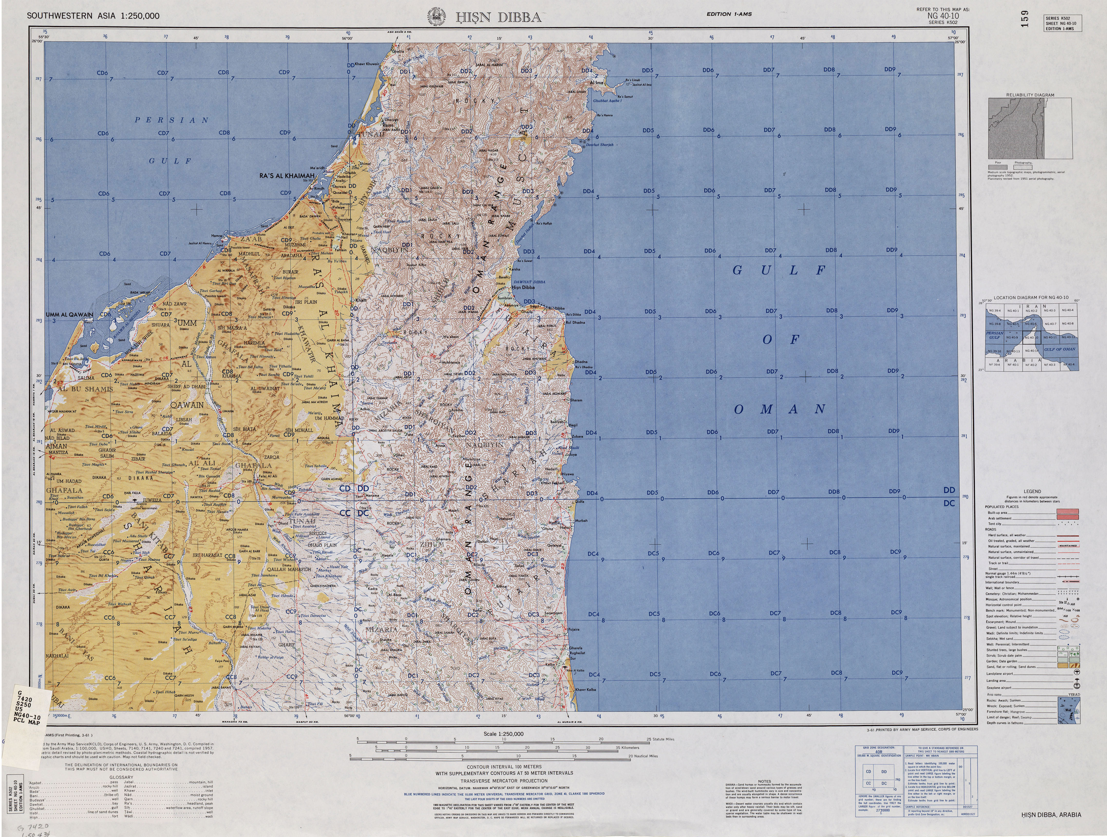
| bgcolor=#D8D8D8 | Jabal Harf Tila || {{refn|group=lower-alpha|Alternative Names: Jabal Harf Tila (major)}}<ref name="Hisn Dibba Map">{{cite web |publisher=maps.lib.utexas.edu |title=Hisn Dibba Map |url=https://maps.lib.utexas.edu/maps/ams/southwestern_asia/txu-pclmaps-oclc-6631562-NG40-10.jpg |access-date=2022-12-22}}</ref><ref name="Tila2">{{cite web |publisher=Wikiloc - Rutas del Mundo|title=Wadi Naqab, Bristly Ridge, Jebel Harf Tila and the Villages |url=https://www.wikiloc.com/hiking-trails/wadi-naqab-bristly-ridge-jebel-half-tila-and-the-villages-24052802 |access-date=2023-05-08}}</ref><ref name="Tila1">{{cite web |publisher=Wikiloc - Rutas del Mundo |title=Wadi Taween to Wadi Naqab via Jebel Half Tila |url=https://es.wikiloc.com/rutas-senderismo/w2w-trail2-wadi-taween-to-wadi-naqab-via-jebel-half-tila-89285277 |access-date=2023-05-08}}</ref>|| 023 || [[Hajar Mountains]] || {{OMA}}<br />{{UAE}} ||[[Musandam Governorate|Musandam]]<br /><br />{{ |
| bgcolor=#D8D8D8 | Jabal Harf Tila || {{refn|group=lower-alpha|Alternative Names: Jabal Harf Tila (major)}}<ref name="Hisn Dibba Map">{{cite web |publisher=maps.lib.utexas.edu |title=Hisn Dibba Map |url=https://maps.lib.utexas.edu/maps/ams/southwestern_asia/txu-pclmaps-oclc-6631562-NG40-10.jpg |access-date=2022-12-22}}</ref><ref name="watersupply">{{cite web |publisher=Arabian Gulf Digital Archives |title=Water supply - Ref. FO 371/163058 - 1962 - The National Archives, London, England |url=https://www.agda.ae/en/catalogue/tna/fo/371/163058/n/33 |access-date=2024-06-09}}</ref><ref name="Tila2">{{cite web |publisher=Wikiloc - Rutas del Mundo|title=Wadi Naqab, Bristly Ridge, Jebel Harf Tila and the Villages |url=https://www.wikiloc.com/hiking-trails/wadi-naqab-bristly-ridge-jebel-half-tila-and-the-villages-24052802 |access-date=2023-05-08}}</ref><ref name="Tila1">{{cite web |publisher=Wikiloc - Rutas del Mundo |title=Wadi Taween to Wadi Naqab via Jebel Half Tila |url=https://es.wikiloc.com/rutas-senderismo/w2w-trail2-wadi-taween-to-wadi-naqab-via-jebel-half-tila-89285277 |access-date=2023-05-08}}</ref>|| 023 || [[Hajar Mountains]] || {{OMA}}<br />{{UAE}} ||[[Musandam Governorate|Musandam]]<br /><br />{{flagcountry|Ras al-Khaimah}} || align=right| {{formatnum:1568}} || {{coord|25|41|21.4|N|56|09|30.6|E|name=Jabal Harf Tila}} |
||
|-valign= top |
|-valign= top |
||
| Line 113: | Line 116: | ||
|-valign= top |
|-valign= top |
||
| bgcolor=#D8D8D8 | Jabal Yabana || {{refn|group=lower-alpha|Alternative Names: Jabal Yabana (major), Jabal Yabbānah, Jabal Yabana, Jabal Yabanah, Jabal Yabānah.}}<ref name="tribulus"/><ref name="map1971" /><ref name="atlas"> Jāmiʻat al-Imārāt al-ʻArabīyah al-Muttaḥidah. Geoprojects (U.K.) Ltd., The National atlas of the United Arab Emirates, Al Ain : United Arab Emirates University - 1993</ref><ref name="yab">{{cite web |publisher=Mindat.org |title=Mindat - Jabal Yabānah |url=https://www.mindat.org/feature-390006.html |access-date=2023-05-08}}</ref> || 025 || [[Hajar Mountains]] || {{OMA}}<br />{{UAE}} ||[[Musandam Governorate|Musandam]]<br /><br />{{ |
| bgcolor=#D8D8D8 | Jabal Yabana || {{refn|group=lower-alpha|Alternative Names: Jabal Yabana (major), Jabal Yabbānah, Jabal Yabana, Jabal Yabanah, Jabal Yabānah.}}<ref name="tribulus"/><ref name="map1971" /><ref name="atlas"> Jāmiʻat al-Imārāt al-ʻArabīyah al-Muttaḥidah. Geoprojects (U.K.) Ltd., The National atlas of the United Arab Emirates, Al Ain : United Arab Emirates University - 1993</ref><ref name="yab">{{cite web |publisher=Mindat.org |title=Mindat - Jabal Yabānah |url=https://www.mindat.org/feature-390006.html |access-date=2023-05-08}}</ref> || 025 || [[Hajar Mountains]] || {{OMA}}<br />{{UAE}} ||[[Musandam Governorate|Musandam]]<br /><br />{{flagcountry|Ras al-Khaimah}} || align=right| {{formatnum:1480}} || {{Coord|25|52|30.0|N|56|09|36.0|E|name=Jabal Yabana}} |
||
|-valign= top |
|-valign= top |
||
| Line 143: | Line 146: | ||
|-valign= top |
|-valign= top |
||
| bgcolor=#D8D8D8 | Jabal Bu Faraj ||{{refn|group=lower-alpha|Alternative Names: Jabal Bu Faraj, Jabal Abu Faraj, Jabal Bū Faraj, Jabal Bū Farāj.}}<ref name="border"/><ref name="atlas" /><ref>{{cite web |publisher=Mindat.org |title=Mindat - Jabal Bu Faraj |url=https://www.mindat.org/feature-288653.html |access-date=2023-05-13}}</ref>|| 035 || [[Hajar Mountains]] || {{OMA}}<br />{{UAE}} ||[[Al Buraimi Governorate|Al Buraimi]]<br /><br />{{ |
| bgcolor=#D8D8D8 | Jabal Bu Faraj ||{{refn|group=lower-alpha|Alternative Names: Jabal Bu Faraj, Jabal Abu Faraj, Jabal Bū Faraj, Jabal Bū Farāj.}}<ref name="border">{{cite web |publisher=Arabian Gulf Digital Archives |title=FO 371/132797 - Frontiers between Muscat and Trucial States- 1958 - The National Archives, London, England |url=https://www.agda.ae/en/catalogue/tna/fo/371/132797/n/106 |access-date=2023-05-13}} </ref><ref name="atlas" /><ref>{{cite web |publisher=Mindat.org |title=Mindat - Jabal Bu Faraj |url=https://www.mindat.org/feature-288653.html |access-date=2023-05-13}}</ref>|| 035 || [[Hajar Mountains]] || {{OMA}}<br />{{UAE}} ||[[Al Buraimi Governorate|Al Buraimi]]<br /><br />{{flagcountry|Ras al-Khaimah}} || align=right| {{formatnum:889}} || {{Coord|24|52|15.92|N|56|03|43.06|E|name=Jabal Bu Faraj}} |
||
|} |
|} |
||
Latest revision as of 09:04, 22 June 2024

.jpg)

.jpg)


Although much of the country has a desert or semi-desert and relatively flat territory, Oman has mountains that include the Hajar Mountains (Arabic: جبال الحجر), located in the northeast of Oman and the far northeast of the United Arab Emirates. These mountains constitute the tallest mountain range in the eastern part of the Arabian Peninsula.
The highest peaks are found in the Jebel Akhdar Mountains (in Arabic: الجبل الأخض), mountain massif approximately 80 km (50 mi) long and 32 km (20 mi) wide, belonging to the Hajar Mountains,[1] which covers an area of 1,135 km2 (438 sq mi) located above 1,500 m (4,900 ft), of which, 410 km2 (160 sq mi) are located above 2,000 m (6,600 ft), and 30 km2 (12 sq mi) are above 2,500 m (8,200 ft).[2]
On the other hand, some of the most relevant peaks, although of lower altitude, are located on the border between Oman and the United Arab Emirates, since in some cases, their position was taken as a reference for the defining the border between the two countries.[3]
However, although a boundary agreement was signed and ratified in 2003, covering the entire border between Oman and the United Arab Emirates, including Oman's enclaves on the Musandam Peninsula and in Mahdah, the contents of the agreement have not yet been published, nor detailed maps showing the alignment,[4] despite the fact that some border markers and fences have already been placed on the ground. The future publication of these agreements and maps could make it necessary to modify the content of this annex.
This list includes the name and location of the summits located entirely within the territory of Oman, or at least with its summit located on the border line, regardless of its height. The list is open to new additions referring to mountains that meet these conditions, with a known name and position, and whose reference data is supported by historical maps or other reliable documentary sources.
The list only includes the mountains that, by an objective classification, can be considered as independent and individual mountains, as opposed to subsidiary mountains of a larger one, sub-summits or simple high points.
Many of these mountains are known by different names, the result of local tradition and of the various transcriptions from Arabic to English, so that an individual reference note includes the alternative names with which the mountain has been identified at some point, accompanied by their respective documentary sources.
The region is represented in different satellite images, mainly Google Earth, Google Satellite and Bing Satellite. The exact coordinates of each summit and its altitude, with respect to the sea level, have been established by comparing the OpenTopoMap and OpenMapTiles topographic maps with these images, treating each with the greatest objectivity and the same measurement criteria for all the summits. In some cases, direct recognition and location by GPS have also been used, or references have been checked against data provided by hikers and climbers in itineraries published online.
References provided by the prestigious geographic database of the National Geospatial-Intelligence Agency of the United States Department of Defense have also been taken into account.
In this version of the article, the values of prominence, nor topographic isolation, were not taken into account to give priority to the task of identifying toponyms and locating the summits.
Mountains of Oman
[edit]Notas
[edit]- ^ Alternative Names: Jabal ash Shām, Jabal Sham, Wishām, Jabal Shams, Jabal ash Sham, Wisham, جبل شمس
- ^ Alternative Names: Jabal-al-Kor, Jabal Kaur, Jabal Kawr, Jabal al Kawr, Jebel Khaur, Jebel-al-Kor,Jebel Kaur, Jebel Kawr, Jebel al Kawr
- ^ Alternative Names: Qarn Wukān
- ^ Alternative Names: Jabal Qayut, Jabal Qayūt, Jabal Qiyut,J abal Qiyūt, Jebel Qayūt
- ^ Alternative Names: Qarn al Ḩammām, قرن الحمام
- ^ Alternative Names: Jabal Khadar, Jabal Khaḑar, jbl khdr, جبل خدر
- ^ Alternative Names: Qarn al Khuz̧ar, Qarn Khuz̧ar
- ^ Alternative Names: Jabal Misht, Jebel Misht, Jabal Mishţ, jbl msht, جبل مشط
- ^ Alternative Names: Jabal Harim, Jebal Al Harim, Jabal al Harim, Jabal al Ḩarīm, Jebal Harim, Jebel Harim, Jabal Ḥārim, Jabal Ḩārim, Jabal Ra'an al-Harim, Shaam Peak, Shuam Peak, jbl harm, جبل حارم
- ^ Alternative Names: Jabal Nakhal, Jabal Nakhl, جبل نخل
- ^ Alternative Names: Ras ash Shayf
- ^ Alternative Names: Jabal Ghūl, Jabal Ghul
- ^ Alternative Names: Ras al Kabūl, Ras al Kabul, Ras Kabul, Ra’s al Jabūl
- ^ Alternative Names: Jabal al Jaru`, Jabal al Jarū‘, جبل الجروع
- ^ Alternative Names: Jabal Bal `Isa, Jabal Bal ‘Īsá, Jabal Bil `Ays, Jabal Bil `Isa, Jabal Bil ‘Ays, Jabal Bil ‘Īsá, Jabal Bu al `Ays, Jabal Bū al ‘Ays, Jabal Rawala, Jabal Rawla, Jabal Rawlah, جبل بل عيسى
- ^ Alternative Names: Jabal Aswad.
- ^ Alternative Names: Jabal Ḩaymar, Jabal Ḩaymir, Jabal Ḥaymur,جبل حيمر
- ^ Alternative Names: Jabal Bani Jabir, Jabal Banī Jābir, Jebel Bani Jabir, Jebel Banī Jābir, jbl bny jabr, جبل بني جابر.
- ^ Alternative Names: Jabal as Sayh, Jabal as Sayḩ.
- ^ Alternative Names: Jabal Kawa, Jabal Qa`wa, Jabal Qa`wah, Jabal Qa‘wa, Jabal Qa‘wah, Jabal Qihwi, Jebel Qihwi, Jebel Qa‘wah, Jabal Qa'wah, Jabal Qa'awah
- ^ Alternative Names: Jebel Hadaba.
- ^ Alternative Names: Jebel Tafif, Jabal Ţafīf, jbl tfyf
- ^ Alternative Names: Jabal Harf Tila (major)
- ^ Alternative Names: Jabal Khanzur, Jabal Khanzūr, jbl khnzwr, جبل خنزور
- ^ Alternative Names: Jabal Yabana (major), Jabal Yabbānah, Jabal Yabana, Jabal Yabanah, Jabal Yabānah.
- ^ Alternative Names: Jabal Hagab, Jabal Haqab, Jabal Haqb, Jabal Ḥaqb, Jabal Ḩaqab, jbl hqb, جبل حقب
- ^ Alternative Names: Jebel Bahar, Jabal Baḩr, Jabal Al Bahar
- ^ Alternative Names: Al Jabal al Abyad, Al Jabal al Abyaḍ, Al Jabal al Abyaḑ, Jabal Abyad, Jabal Abyaḑ, Jabal al Abyad, Jabal al Abyaḍ, Jabal al Abyaḑ, aljbl alabyd, jbl alabyd, الجبل الأبيض, جبل الأبيض
- ^ Alternative Names: Jebel Sham, Jabal Shām
- ^ Alternative Names: Jabal al Ḩārah, Jabal Fine, Ras al Ḩārah, Jabal al Harah, Jabal al Ḥārrah, Fine Peak
- ^ Alternative Names: Jabal Hajarain, Jabal Ḩajarayn, Jabal Hajarayn, Jabal Ḩattá, Jabal Ḩaţţah, Jabal Hattah, Jabal Hatta, Um Alnosoor, Umm Alnosoor, Jabal Umm Nasur.
- ^ Alternative Names: Jabal Hālāt, Jebel Halat
- ^ Alternative Names: Djabel Hafit, Djabel Ḩafīt, Jabal Hafi, Jabal Hafit, Jabal Ḥafī, Jabal Ḥafīt, Jabal Ḩafīt, jbl hfyt, جبل حفيت
- ^ Alternative Names: Jabal Sumayni, Jabal Sumaynī, Jabal Sumeini, Jabal as Sumaini, Jabal as Sumayni, Jabal as Sumaynī, jbl alsmyny, جبل السّميني
- ^ Alternative Names: Jabal Bu Faraj, Jabal Abu Faraj, Jabal Bū Faraj, Jabal Bū Farāj.
Véase también
[edit]- List of wadis of Oman
- List of mountains in the United Arab Emirates
- List of wadis of the United Arab Emirates
Referencias
[edit]- ^ https://www.agda.ae/en/catalogue/tna/air/5/1284/n/39 Persian Gulf and Arabian Coast: mountains or mounds - Ref. AIR 5/1284 - PAGE 39 - The National Archives, London, England
- ^ a b c d e f g h Tribulus - Volume 19 - 2011 - Journal of the Emirates Natural History Group - The Flora of the Ru'us al-Jibal -the Mountains of the Musandam Peninsula: An Annotated Checklist and Selected Observations - Gary R. Feulner - Abu Dhabi, United Arab Emirates, 2011<https://enhg.org/Portals/1/trib/V19/TribulusV19.pdf>
- ^ a b "FO 371/132797 - Frontiers between Muscat and Trucial States- 1958 - The National Archives, London, England". Arabian Gulf Digital Archives. Retrieved 2023-05-13.
- ^ "The World Factbook". CIA.gov. Retrieved 2023-05-08.
- ^ https://www.agda.ae/en/catalogue/tna/air/5/1284/n/55 Persian Gulf and Arabian Coast: mountains or mounds - Ref. AIR 5/1284 - PAGE 55 - The National Archives, London, England
- ^ www.geoview.info - Jabal Shams
- ^ https://www.peakbagger.com/peak.aspx?pid=13231 www.peakbagger.com - Jebel Shams, Oman
- ^ Trekking path to the southern summit of Jabal Shams from ‘The Plateau’ - Ministry of Tourism <https://web.archive.org/web/20130309194328/http://www.omantourism.gov.om/wps/wcm/connect/ac5623804470a00db4dabfbf0c53e49e/trekking+routs3.pdf?MOD=AJPERES&CONVERT_TO=url&CACHEID=ac5623804470a00db4dabfbf0c53e49e]
- ^ https://www.agda.ae/en/catalogue/tna/air/5/1284/n/55 Persian Gulf and Arabian Coast: mountains or mounds - Ref. AIR 5/1284 - 1936 - The National Archives, London, England
- ^ "Peakbagger - Jebel Kawr, Oman". peakbagger.com. Retrieved 2024-05-30.
- ^ https://www.agda.ae/en/catalogue/tna/air/5/1284/n/35 Persian Gulf and Arabian Coast: mountains or mounds - Ref. AIR 5/1284 - 1936 - The National Archives, London, England
- ^ https://www.agda.ae/en/catalogue/tna/fo/371/162864/n/53 Sultan's Armed Forces - Ref. FO 371/162864 - 1962 - The National Archives, London, England
- ^ https://www.agda.ae/en/catalogue/tna/fo/464/33/n/115 Arabia: arbitration concerning Buraimi and the common frontier between Abu Dhabi and Saudi Arabia; memorial submitted by the UK Government, volume 2, annexes - Ref. FO 464/33 - 1955 - The National Archives, London, England
- ^ "Qarn Wukān". Peakvisor. Retrieved 2024-06-06.
- ^ "Qarn Wukān GNS:id 14497623". National Geospatial-Intelligence Agency (NGA). Retrieved 2024-06-06.
- ^ www.peakbagger.com - Jebel Qiyut, Oman
- ^ "Qarn al Ḩammām". om.geoview.info. Retrieved 2024-06-02.
- ^ "Jabal Khadar, Ash Sharqiyah South, Oman". Mindat.org. Retrieved 2024-05-30.
- ^ "Qarn al Khuzar". Peakvisor. Retrieved 2024-06-06.
- ^ "Qarn al Khuz̧ar GNS:id -787743". National Geospatial-Intelligence Agency (NGA). Retrieved 2024-06-06.
- ^ "Qarn al Khuz̧ar". om.geoview.info. Retrieved 2024-06-06.
- ^ "Jabal Mishţ GNS:id -788076". National Geospatial-Intelligence Agency (NGA). Retrieved 2024-06-06.
- ^ "Jabal Mishţ, Muḩāfaz̧at ad Dākhilīyah, Oman". Mindat.org. Retrieved 2024-06-04.
- ^ www.peakbagger.com - Jebel Misht, Oman
- ^ "Jebel Misht, Oman / جبل مشط - anton_hkng|". www.wikiloc.com. Retrieved 2024-06-04.
- ^ "Mindat - Jabal Ḩārim". Mindat.org. Retrieved 2023-05-30.
- ^ a b c d e "FCO 18/1863 - Map of Trucial States, Muscat and Oman - Rams - Scale 1:100 000 - Published by D Survey, Ministry of Defence, United Kingdom (1971) - Edition 3-GSGS - The National Archives, London, England". Arabian Gulf Digital Archives. Retrieved 2023-05-08.
- ^ www.peakbagger.com - Jebel al Harim, Oman
- ^ Lancaster, William; Lancaster, Fidelity (July 2011). Honour is in Contentment: Life Before Oil in Ras Al-Khaimah (UAE) and Some Neighbouring Regions. Walter de Gruyter. ISBN 9783110223408.
- ^ https://www.agda.ae/en/catalogue/tna/air/5/1284/n/26 Persian Gulf and Arabian Coast: mountains or mounds - Ref. AIR 5/1284 - 1936 - The National Archives, London, England
- ^ "FCO 18/1897 Map Boundaries of the Northern Trucial States (1963) - The National Archives, London, England". Arabian Gulf Digital Archives. Retrieved 2023-05-08.
- ^ https://www.agda.ae/en/catalogue/tna/air/5/1284/n/43 Persian Gulf and Arabian Coast: mountains or mounds - Ref. AIR 5/1284 - PAGE 43 - The National Archives, London, England
- ^ "Geoview - Jabal Nakhl". geoview.info. Retrieved 2024-06-02.
- ^ "Ras ash Shayf". Peakvisor. Retrieved 2024-06-06.
- ^ "Ra's ash Shayf GNS:id -788857". National Geospatial-Intelligence Agency (NGA). Retrieved 2024-06-06.
- ^ "Ra's ash Shayf". om.geoview.info. Retrieved 2024-06-06.
- ^ "Geoview - Jabal Ghūl". geoview.info. Retrieved 2024-05-30.
- ^ "Peakbagger - Jabal Ghul, Oman". peakbagger.com. Retrieved 2024-05-30.
- ^ "Ras al Kabul". Peakvisor. Retrieved 2024-06-06.
- ^ "Ra's al Jabūl GNS:id -787560". National Geospatial-Intelligence Agency (NGA). Retrieved 2024-06-06.
- ^ "Ra's al Kabūl". om.geoview.info. Retrieved 2024-06-06.
- ^ "Mindat - Jabal al Jarū', Al Batinah South Governorate, Oman". Mindat.org. Retrieved 2024-05-30.
- ^ "Mindat - Jabal Bil 'Ays, United Arab Emirates". Mindat.org. Retrieved 2024-05-30.
- ^ "Peakbagger - Jabal Bil Ays, Oman". peakbagger.com. Retrieved 2024-05-30.
- ^ "Jabal Aswad". om.geoview.info. Retrieved 2024-05-06.
- ^ Journal of Arid Environments - ELSEVIER - Vegetation patterns and diversity along an altitudinal and a grazing gradient in the Jabal al Akhdar mountain range of northern Oman - Katja Brinkmann, Annette Patzelt, Uta Dickhoefer, Eva Schlecht, Andreas Buerkert - 2008<http://w.sulama.de/documents/publications/Brinkmann_2009.pdf>
- ^ "Geoview - Jabal Ḩaymir". geoview.info. Retrieved 2024-06-06.
- ^ "Jabal Banī Jābir, Ash Sharqiyah South, Oman". Mindat.org. Retrieved 2024-05-06.
- ^ "Mindat - Jabal as Sayḩ". Mindat.org. Retrieved 2023-05-08.
- ^ "Jebel Qihwi - Western Route - Wadi Niqab - Ben Robbins|". www.wikiloc.com. Retrieved 2024-05-20.
- ^ FCO 18/1920 - 1962 - Boundaries of the Northern Trucial States: prepared and drawn from sketch maps and information supplied by Julian Walker; preliminary edition<https://www.agda.ae/en/catalogue/tna/fco/18/1920>
- ^ FCO 18/1932 - 1958 - Sketch map drawn by Julian Walker for boundary delimitation: Ras Al Khaimah<https://www.agda.ae/en/catalogue/tna/fco/18/1932>
- ^ FCO 18/1969 - 1959 - Sketch map drawn by Julian Walker for boundary delimitation: Dibba - The National Archives, London, England <https://www.agda.ae/en/catalogue/tna/fco/18/1969>
- ^ "Wadi Bih (UAE) to Jebel Tafif (Oman)". Wikiloc - Trails of the World. Retrieved 2024-06-03.
- ^ "Hisn Dibba Map". maps.lib.utexas.edu. Retrieved 2022-12-22.
- ^ "Water supply - Ref. FO 371/163058 - 1962 - The National Archives, London, England". Arabian Gulf Digital Archives. Retrieved 2024-06-09.
- ^ "Wadi Naqab, Bristly Ridge, Jebel Harf Tila and the Villages". Wikiloc - Rutas del Mundo. Retrieved 2023-05-08.
- ^ "Wadi Taween to Wadi Naqab via Jebel Half Tila". Wikiloc - Rutas del Mundo. Retrieved 2023-05-08.
- ^ "Mindat - Jabal Khanzūr, Musandam, Oman". Mindat.org. Retrieved 2024-06-06.
- ^ a b c Jāmiʻat al-Imārāt al-ʻArabīyah al-Muttaḥidah. Geoprojects (U.K.) Ltd., The National atlas of the United Arab Emirates, Al Ain : United Arab Emirates University - 1993
- ^ "Mindat - Jabal Yabānah". Mindat.org. Retrieved 2023-05-08.
- ^ "Mindat - Jabal Ḩaqab, Musandam, Oman". Mindat.org. Retrieved 2024-06-02.
- ^ "Jabal Bahar, Oman". Peakbagger.com. Retrieved 2024-06-04.
- ^ "Wadi Ghail - Jebel Bahar Hike. Ras al Khaimah - Patrick Vijay D'Silva|". www.wikiloc.com. Retrieved 2024-06-04.
- ^ "Map of the Sultanate of Oman". Foreign Ministry of the Sultanate of Oman. Retrieved 2024-05-02.
- ^ "Mindat - Al Jabal al Abyaḑ, Az̧ Z̧āhirah, Oman". Mindat.org. Retrieved 2023-06-02.
- ^ "Mindat - Jabal Shām, Az̧ Z̧āhirah, Oman". Mindat.org. Retrieved 2023-06-05.
- ^ "FCO 18/1861 Map Oman and the United Arab Emirates (UAE): Khasab (1975) - The National Archives, London, England". Arabian Gulf Digital Archives. Retrieved 2024-05-30.
- ^ "GeoNames - Um Alnosoor". GeoNames.org. Retrieved 2023-05-08.
- ^ "FCO 18/1796 - Map of Trucial States, Muscat and Oman - Aswad - Scale 1:100 000 - Published by D Survey, Ministry of Defence, United Kingdom (1971) - Edition 3-GSGS - The National Archives, London, England". Arabian Gulf Digital Archives. Retrieved 2023-05-08.
- ^ a b "FCO 18/1898 Map Boundaries of the Northern Trucial States (1963) - The National Archives, London, England". Arabian Gulf Digital Archives. Retrieved 2023-05-08.
- ^ "Um Alnosoor trail". Wikiloc - Trails of the World. Retrieved 2023-05-12.
- ^ "Jabal Hālāt, Az̧ Z̧āhirah, Oman". Mindat.org. Retrieved 2023-06-05.
- ^ "Mindat - Jabal Ḩafīt". Mindat.org. Retrieved 2023-05-08.
- ^ "Jebel Hafeet, United Arab Emirates". Peakbagger.com. Retrieved 2023-05-09.
- ^ "FCO 18/1850 Oman and the United Arab Emirates (UAE): Jebel Al Rawdah, with handwritten annotations (1970) - The National Archives, London, England". Arabian Gulf Digital Archives. Retrieved 2024-06-03.
- ^ "Jabal as Sumaynī, Muḩāfaz̧at al Buraymī, Oman". Mindat.org. Retrieved 2023-05-13.
- ^ "Mindat - Jabal Bu Faraj". Mindat.org. Retrieved 2023-05-13.
Hills and mountains on the Arabian Peninsula | |
|---|---|
Note: Mountains are sorted in alphabetical order, unless where it concerns ranges. The highest confirmed mountains in each country are indicated with 'HP', and those with the highest peak are indicated with 'HP', bearing in mind that in the UAE, the highest mountain and the mountain with the highest peak are different. Outcrops are indicated with 'OC', and outliers with 'OL', and anticlines with 'AC'. Volcanoes are indicated with 'V', volcanic craters with 'VC', lava fields with 'LF', and volcanic fields with 'VF'.
Other notes:
|
.jpg)


.jpg)