
Joint Forces Operation (Ukraine): Difference between revisions
Tags: Mobile edit Mobile web edit Advanced mobile edit |
Longhornsg (talk | contribs) −Category:Counterterrorism; +Category:Counterterrorist organizations using HotCat replacing with subcat |
||
| (25 intermediate revisions by 20 users not shown) | |||
| Line 1: | Line 1: | ||
{{Short description|Official name for territory where the |
{{Short description|Official name for territory where the war in Donbass takes place}} |
||
{{about|a territory where the [[War in Donbas (2014–2022)]] takes place|Russian military invasion sequence| |
{{about|a territory where the [[War in Donbas (2014–2022)]] takes place|Russian military invasion sequence|Russo-Ukrainian War|other uses of "ATO"|ATO (disambiguation)}}{{Update|date=May 2023}}[[File:East Ukraine conflict dynamics.gif|thumb|Animated map of ATO zone]] |
||
'''Anti-Terrorist Operation Zone''' ({{lang-uk|Зона проведення антитерористичної операції|translit=Zona provedennya antyterorystychnoyi operatsiyi}}), or '''ATO zone'''<ref>Tomkiw, L. ''[http://www.ibtimes.com/ukraine-war-forces-nation-talk-about-taboo-post-traumatic-stress-disorder-1869506 Ukraine War Forces A Nation To Talk About A Taboo: Post-Traumatic Stress Disorder] {{Webarchive|url=https://web.archive.org/web/20151003071624/http://www.ibtimes.com/ukraine-war-forces-nation-talk-about-taboo-post-traumatic-stress-disorder-1869506 |date=2015-10-03 }}''. [[International Business Times]]. 4 April 2015</ref> ({{lang-uk|Зона АТО|translit=Zona ATO}}), was a term used by the media, publicity, the government of [[Ukraine]], and the [[OSCE]]<ref>{{Cite web |date=10 November 2015 |title=OSCE High Commissioner on National Minorities assesses inter-ethnic situation in south-eastern Ukraine |url=https://www.osce.org/hcnm/198856 |website=[[osce.org]]}}</ref> and other foreign institutions<ref>[http://ukraine.usembassy.gov/statements/ambpyatt-baer-donetskregion-07302015.html U.S. Ambassador to Ukraine Geoffrey Pyatt and U.S. Ambassador to the OSCE Daniel Baer Travel to Donetsk Oblast] {{Webarchive|url=https://web.archive.org/web/20150914163405/http://ukraine.usembassy.gov/statements/ambpyatt-baer-donetskregion-07302015.html|date=2015-09-14}}. [[United States Embassy in Ukraine]]. 30 July 2015</ref> to identify Ukrainian territory of the [[Donetsk Oblast|Donetsk]] and [[Luhansk Oblast|Luhansk]] regions (oblasts)<ref>[https://web.archive.org/web/20151009181144/http://www.sbu.gov.ua/sbu/control/uk/publish/article?art_id=136476&cat_id=135945 Updated provisional order to enter and leave the uncontrolled territory for citizens of Ukraine and foreigners (individuals without citizenship) as of 28 September 2015 (Оновлений тимчасовий порядок в'їзду на неконтрольовану територію та виїзду з неї громадян України та іноземців (осіб без громадянства) станом на 28.09.2015 року)]. (official document) [[Security Service of Ukraine]].</ref> under the control of Russian military forces<ref>{{Cite news|url=https://www.rferl.org/a/ukraine-russia-creeping-offensive-escalation-fighting/28268104.html|title=Anxious Ukraine Risks Escalation In 'Creeping Offensive'|newspaper=Radio Free Europe/Radio Liberty|date=30 January 2017 |access-date=2017-11-16|archive-date=2022-02-22|archive-url=https://web.archive.org/web/20220222030958/https://www.rferl.org/a/ukraine-russia-creeping-offensive-escalation-fighting/28268104.html|url-status=live |last1=Miller |first1=Christopher }}</ref>{{#tag:ref|Russia's official position on the presence of Russian forces in Ukraine's [[Donbas]] region prior to the [[2022 Russian invasion of Ukraine]] was vague: while official bodies denied presence of "regular armed forces" in Ukraine, on numerous occasions Russia confirmed the presence of "military specialists" and used other [[euphemism]]s, usually accompanied by an argument that Russia "was forced" to deploy them to "defend Russian-speaking population".<ref>''The Interpreter'' quoted what Putin said during a live call-in session on 12 October 2016:<br>"When we were forced, I want to stress, forced to defend the Russian-speaking population in the Donbas, forced to respond to the desire of the people living in Crimea to return to being part of the Russian Federation, they instantly began to whip up anti-Russian policies and the imposition of sanctions."<br>{{citation |url= http://www.interpretermag.com/day-968/#15291 |title= Putin Claims Russia Was 'Forced To Defend Russian-Speaking Population In Donbas' |newspaper= The Interpreter |date= 12 October 2016 |access-date= 8 January 2018 |archive-date= 23 February 2022 |archive-url= https://web.archive.org/web/20220223163713/https://www.interpretermag.com/day-968/#15291 |url-status= live }}</ref><ref>{{Cite news|url=https://www.telegraph.co.uk/news/worldnews/vladimir-putin/12054164/Vladimir-Putins-annual-press-conference-2015-live.html|title=Vladimir Putin admits: Russian troops 'were in Ukraine'|last=Oliphant|first=Roland|journal=Daily Telegraph|date=2015-12-17|access-date=2018-01-09|language=en-GB|issn=0307-1235|archive-date=2018-01-09|archive-url=https://web.archive.org/web/20180109203746/http://www.telegraph.co.uk/news/worldnews/vladimir-putin/12054164/Vladimir-Putins-annual-press-conference-2015-live.html|url-status=live}}</ref>|group=nb}} and pro-Russian separatists. A significant part of ATO zone is considered [[Temporarily occupied and uncontrolled territories of Ukraine (2014-present)|temporarily occupied territory of Ukraine]].<ref>[http://news.liga.net/news/politics/6394338-zona_ato_den_nachalsya_s_obstrelov_gradami_bliz_donetska.htm ATO zone: Day started with Grads shooting near Donetsk (Зона АТО: день начался с обстрелов Градами близ Донецка)] {{Webarchive|url=https://web.archive.org/web/20150822020446/http://news.liga.net/news/politics/6394338-zona_ato_den_nachalsya_s_obstrelov_gradami_bliz_donetska.htm|date=2015-08-22}}. [[LIGA News]]. 12 August 2015</ref> |
|||
[[File:East Ukraine conflict dynamics.gif|thumb|Animated map of ATO zone]] |
|||
'''Anti-Terrorist Operation Zone''' (''{{lang-uk|Зона проведення антитерористичної операції|translit=Zona provedennya antyterorystychnoyi operatsiyi}}''), or '''ATO zone'''<ref>Tomkiw, L. ''[http://www.ibtimes.com/ukraine-war-forces-nation-talk-about-taboo-post-traumatic-stress-disorder-1869506 Ukraine War Forces A Nation To Talk About A Taboo: Post-Traumatic Stress Disorder] {{Webarchive|url=https://web.archive.org/web/20151003071624/http://www.ibtimes.com/ukraine-war-forces-nation-talk-about-taboo-post-traumatic-stress-disorder-1869506 |date=2015-10-03 }}''. [[International Business Times]]. 4 April 2015</ref> (''{{lang-uk|Зона АТО|translit=Zona ATO}}''), is a term used by the media, publicity and government of [[Ukraine]], and the [[OSCE]]{{citation needed|date=May 2022}} and other foreign institutions<ref>[http://ukraine.usembassy.gov/statements/ambpyatt-baer-donetskregion-07302015.html U.S. Ambassador to Ukraine Geoffrey Pyatt and U.S. Ambassador to the OSCE Daniel Baer Travel to Donetsk Oblast] {{Webarchive|url=https://web.archive.org/web/20150914163405/http://ukraine.usembassy.gov/statements/ambpyatt-baer-donetskregion-07302015.html |date=2015-09-14 }}. [[United States Embassy in Ukraine]]. 30 July 2015</ref> to identify Ukrainian territory of the [[Donetsk Oblast|Donetsk]] and [[Luhansk Oblast|Luhansk]] regions (oblasts)<ref>[https://web.archive.org/web/20151009181144/http://www.sbu.gov.ua/sbu/control/uk/publish/article?art_id=136476&cat_id=135945 Updated provisional order to enter and leave the uncontrolled territory for citizens of Ukraine and foreigners (individuals without citizenship) as of 28 September 2015 (Оновлений тимчасовий порядок в'їзду на неконтрольовану територію та виїзду з неї громадян України та іноземців (осіб без громадянства) станом на 28.09.2015 року)]. (official document) [[Security Service of Ukraine]].</ref> under the control of Russian military forces<ref>{{Cite web|url=https://www.rferl.org/a/ukraine-russia-creeping-offensive-escalation-fighting/28268104.html|title=Anxious Ukraine Risks Escalation In 'Creeping Offensive'|website=RadioFreeEurope/RadioLiberty|access-date=2017-11-16|archive-date=2022-02-22|archive-url=https://web.archive.org/web/20220222030958/https://www.rferl.org/a/ukraine-russia-creeping-offensive-escalation-fighting/28268104.html|url-status=live}}</ref>{{#tag:ref|Russia's official position on the presence of Russian forces in Ukraine's [[Donbas]] region prior to the [[2022 Russian invasion of Ukraine]] was vague: while official bodies denied presence of "regular armed forces" in Ukraine, on numerous occasions Russia confirmed the presence of "military specialists" and used other [[euphemism]]s, usually accompanied by an argument that Russia "was forced" to deploy them to "defend Russian-speaking population".<ref>''The Interpreter'' quoted what Putin said during a live call-in session on 12 October 2016:<br>"When we were forced, I want to stress, forced to defend the Russian-speaking population in the Donbas, forced to respond to the desire of the people living in Crimea to return to being part of the Russian Federation, they instantly began to whip up anti-Russian policies and the imposition of sanctions."<br>{{citation |url= http://www.interpretermag.com/day-968/#15291 |title= Putin Claims Russia Was 'Forced To Defend Russian-Speaking Population In Donbas' |newspaper= The Interpreter |date= 12 October 2016 |access-date= 8 January 2018 |archive-date= 23 February 2022 |archive-url= https://web.archive.org/web/20220223163713/https://www.interpretermag.com/day-968/#15291 |url-status= live }}</ref><ref>{{Cite news|url=https://www.telegraph.co.uk/news/worldnews/vladimir-putin/12054164/Vladimir-Putins-annual-press-conference-2015-live.html|title=Vladimir Putin admits: Russian troops 'were in Ukraine'|last=Oliphant|first=Roland|journal=Daily Telegraph|date=2015-12-17|access-date=2018-01-09|language=en-GB|issn=0307-1235|archive-date=2018-01-09|archive-url=https://web.archive.org/web/20180109203746/http://www.telegraph.co.uk/news/worldnews/vladimir-putin/12054164/Vladimir-Putins-annual-press-conference-2015-live.html|url-status=live}}</ref>|group=nb}} and pro-Russian separatists. A significant part of ATO zone is considered [[Temporarily occupied and uncontrolled territories of Ukraine (2014-present)|temporarily occupied territory of Ukraine]].<ref>[http://news.liga.net/news/politics/6394338-zona_ato_den_nachalsya_s_obstrelov_gradami_bliz_donetska.htm ATO zone: Day started with Grads shooting near Donetsk (Зона АТО: день начался с обстрелов Градами близ Донецка)] {{Webarchive|url=https://web.archive.org/web/20150822020446/http://news.liga.net/news/politics/6394338-zona_ato_den_nachalsya_s_obstrelov_gradami_bliz_donetska.htm |date=2015-08-22 }}. [[LIGA News]]. 12 August 2015</ref> |
|||
==History== |
|||
On 20 February 2018, [[Ukrainian President]] [[Petro Poroshenko]] changed the status of the ATO zone from an anti-terrorist operation to "taking measures to ensure national security and defense, and repulsing and deterring the armed aggression of the Russian Federation in Donetsk and Luhansk oblasts".<ref>{{Cite web|url=https://www.kyivpost.com/ukraine-politics/goodbye-ato-hello-taking-measures-ensure-national-security-defense-repulsing-deterring-armed-aggression-russian-federation-donetsk-luhansk-oblasts.html|title=Goodbye, ATO: Ukraine officially changes name of Donbas war - KyivPost - Ukraine's Global Voice|date=February 20, 2018|website=KyivPost|access-date=September 4, 2018|archive-date=November 9, 2020|archive-url=https://web.archive.org/web/20201109015357/https://www.kyivpost.com/ukraine-politics/goodbye-ato-hello-taking-measures-ensure-national-security-defense-repulsing-deterring-armed-aggression-russian-federation-donetsk-luhansk-oblasts.html|url-status=live}}</ref> This allows the [[Ukrainian military]] to take charge of the zones instead of the Ukrainian secret service [[Security Service of Ukraine|SBU]].{{Citation needed|date=June 2022}} As such, the ATO was renamed to '''JFO zone''' ('''Joint Forces Operation''' (''{{lang-uk|Операція об'єднаних сил, ООС|translit=Operatsiya ob'yednanykh syl}}'').<ref>{{Cite web |date=4 May 2018 |title=Old war, new rules: what comes next as ATO ends and a new operation starts in Donbas? |url=https://uacrisis.org/en/66558-joint-forces-operation |access-date=14 April 2022 |website=Ukraine Crisis Media Center}}</ref> |
|||
On 20 February 2018, [[Ukrainian President]] [[Petro Poroshenko]] changed the status of the ATO zone from an anti-terrorist operation to "taking measures to ensure national security and defense, and repulsing and deterring the armed aggression of the Russian Federation in Donetsk and Luhansk oblasts".<ref>{{Cite web|url=https://www.kyivpost.com/ukraine-politics/goodbye-ato-hello-taking-measures-ensure-national-security-defense-repulsing-deterring-armed-aggression-russian-federation-donetsk-luhansk-oblasts.html|title=Goodbye, ATO: Ukraine officially changes name of Donbas war - KyivPost - Ukraine's Global Voice|date=February 20, 2018|website=KyivPost|access-date=September 4, 2018|archive-date=November 9, 2020|archive-url=https://web.archive.org/web/20201109015357/https://www.kyivpost.com/ukraine-politics/goodbye-ato-hello-taking-measures-ensure-national-security-defense-repulsing-deterring-armed-aggression-russian-federation-donetsk-luhansk-oblasts.html|url-status=live}}</ref> |
|||
This allows the [[Ukrainian military]] to take charge of the zones instead of the Ukrainian secret service [[Security Service of Ukraine|SBU]].{{Citation needed|date=June 2022}} As such, the ATO was renamed to '''JFO zone''' ('''Joint Forces Operation''' ({{lang-uk|Операція об'єднаних сил, ООС|translit=Operatsiya ob'yednanykh syl}}).<ref>{{Cite web |date=4 May 2018 |title=Old war, new rules: what comes next as ATO ends and a new operation starts in Donbas? |url=https://uacrisis.org/en/66558-joint-forces-operation |access-date=14 April 2022 |website=Ukraine Crisis Media Center}}</ref> |
|||
Following the [[Russian invasion of Ukraine]], out-of-service ATO [[veterans]] have repeatedly been the target of Russian forces, for example of the [[Redut (company)|Redut PMC]].<ref>{{Cite web |date=24 December 2022 |title=«Трошки пресували, звичайно». Чотирьох військовослужбовців РФ засудили за катування колишніх учасників АТО |url=https://sudreporter.org/troshky-presuvaly-zvychajno-chotyroh-vijskovosluzhbovcziv-rf-zasudyly-za-katuvannya-kolyshnih-uchasnykiv-ato/ |archive-url=https://archive.today/20230611235809/https://sudreporter.org/troshky-presuvaly-zvychajno-chotyroh-vijskovosluzhbovcziv-rf-zasudyly-za-katuvannya-kolyshnih-uchasnykiv-ato/ |archive-date=11 June 2023 |access-date=11 June 2023 |website=Судовий Репортер |language=uk}}</ref> According to captured fighters, with this they wanted to decrease the risk of them joining the defence of Ukraine. For this purpose, veterans were interrogated and tortured in order to find more, after which many were killed. Two [[Redut (company)|Redut PMC]] fighters got convicted for committing such war crimes.<ref name="human">{{Cite web |title=Long sentences passed on 'Redut' mercenaries fighting Russia's war against Ukraine with Finnish citizen's funding |url=https://khpg.org/en/1608811793 |archive-url=https://archive.today/20230503191107/https://khpg.org/en/1608811793 |archive-date=3 May 2023 |access-date=3 May 2023 |website=[[Kharkiv Human Rights Protection Group]]}}</ref> |
|||
==Military administrative division== |
==Military administrative division== |
||
The official borders of the ATO zone were defined with a list of localities and their geographical coordinates, approved in November 2014 by Ukraine's parliament, the [[Verkhovna Rada]].<ref name="Zakon4">{{Cite web |script-title=uk:Про затвердження переліку населених пунктів, на території яких органи державної влади тимчасово не здійснюють свої повноваження, та переліку населених пунктів, що розташовані на лінії зіткнення |url=https://zakon.rada.gov.ua/go/1085-2014-%D1%80 |script-website=uk:Офіційний вебпортал парламенту України}}</ref> |
|||
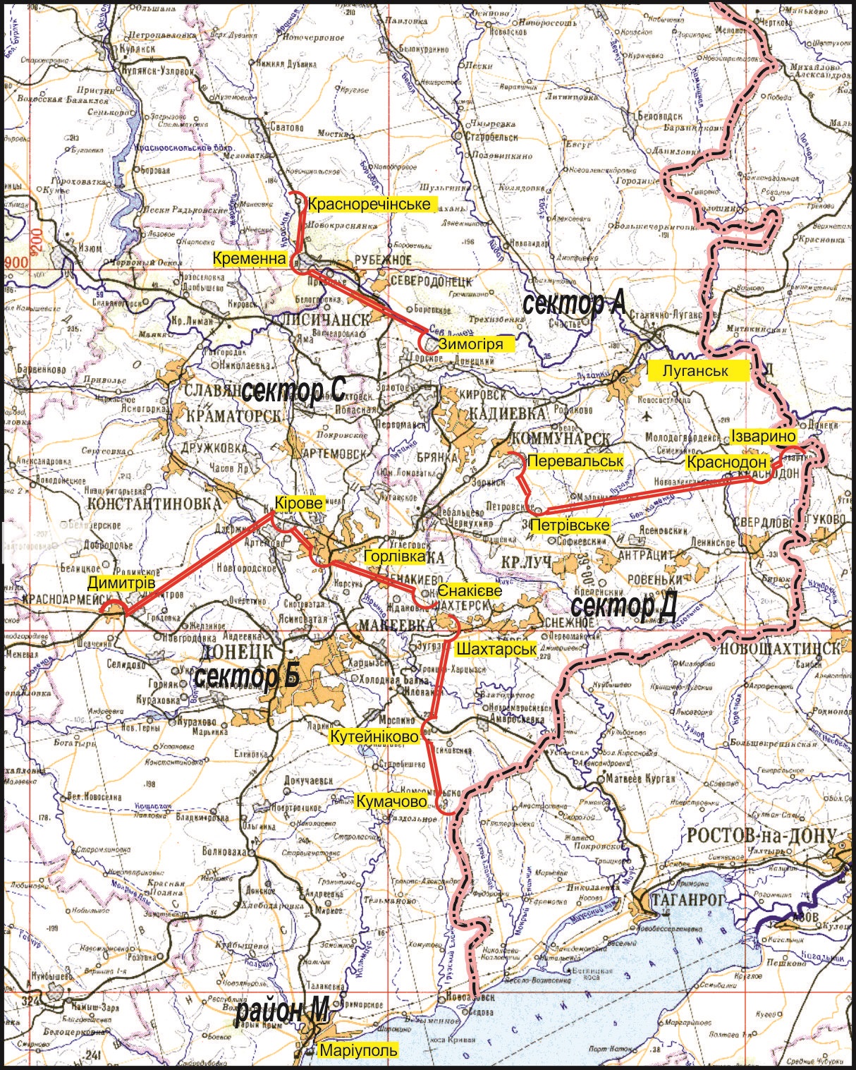
The zone is conditionally divided into five sectors A, B, C, D, and M.<ref>[http://www.depo.ua/static/files/gallery_uploads/images/%D0%9C%D1%96%D0%BD%D0%BE%D0%B1%D1%8C%D0%BE%D1%80%D0%BE%D0%BD%D0%B8.jpg Map of the sectors] {{Webarchive|url=https://web.archive.org/web/20171019052413/https://www.depo.ua/static/files/gallery_uploads/images/%D0%9C%D1%96%D0%BD%D0%BE%D0%B1%D1%8C%D0%BE%D1%80%D0%BE%D0%BD%D0%B8.jpg |date=2017-10-19 }}. depo.ua</ref><ref>[https://napalm.natocdn.work/2015/01/karta-polnayacc.jpg Map of the sectors] {{Webarchive|url=https://web.archive.org/web/20171019054108/https://napalm.natocdn.work/2015/01/karta-polnayacc.jpg |date=2017-10-19 }}. [[Inform Napalm]].</ref> |
The zone is conditionally divided into five sectors A, B, C, D, and M.<ref>[http://www.depo.ua/static/files/gallery_uploads/images/%D0%9C%D1%96%D0%BD%D0%BE%D0%B1%D1%8C%D0%BE%D1%80%D0%BE%D0%BD%D0%B8.jpg Map of the sectors] {{Webarchive|url=https://web.archive.org/web/20171019052413/https://www.depo.ua/static/files/gallery_uploads/images/%D0%9C%D1%96%D0%BD%D0%BE%D0%B1%D1%8C%D0%BE%D1%80%D0%BE%D0%BD%D0%B8.jpg |date=2017-10-19 }}. depo.ua</ref><ref>[https://napalm.natocdn.work/2015/01/karta-polnayacc.jpg Map of the sectors] {{Webarchive|url=https://web.archive.org/web/20171019054108/https://napalm.natocdn.work/2015/01/karta-polnayacc.jpg |date=2017-10-19 }}. [[Inform Napalm]].</ref> |
||
* Sector A – eastern and central parts of [[Luhansk Oblast]] |
* Sector A – eastern and central parts of [[Luhansk Oblast]] |
||
| Line 13: | Line 19: | ||
* Sector D – southern parts of Luhansk Oblast and eastern parts of Donetsk Oblast (after the 2014 Russian invasion on August 24, all Ukrainian forces were withdrawn) |
* Sector D – southern parts of Luhansk Oblast and eastern parts of Donetsk Oblast (after the 2014 Russian invasion on August 24, all Ukrainian forces were withdrawn) |
||
* Sector M – southern parts of Donetsk Oblast (around [[Mariupol]], hence the sector's identification) |
* Sector M – southern parts of Donetsk Oblast (around [[Mariupol]], hence the sector's identification) |
||
==List of landmarks bordering with ATO zone== |
|||
Information as of 7 November 2014.<ref name="Zakon4">{{Cite web|url=https://zakon.rada.gov.ua/go/1085-2014-%D1%80|title=Про затвердження переліку населених пунктів, на території яких органи державної влади тимчасово не здійснюють свої повноваження, та переліку населених пунктів, що розташовані на лінії зіткнення|website=Офіційний вебпортал парламенту України}}</ref> |
|||
{| class="wikitable" |
|||
! colspan="2" style="text-align: center; font-weight: bold;" | In English |
|||
! colspan="2" style="text-align: center; font-weight: bold;" | In Ukrainian |
|||
|- |
|||
| style="text-align: center;" | Settlement name |
|||
or landmark location |
|||
| style="text-align: center;" | Geographic coordinates |
|||
| style="text-align: center;" | Назва населеного пункту |
|||
або орієнтир на місцевості |
|||
| style="text-align: center;" | Географічні координати |
|||
|- |
|||
| style="text-align: center;" | NOVOKYIVKA |
|||
| style="text-align: center;" | North latitude 48 ° 35 ' 27 " |
|||
| style="text-align: center;" | НОВОКИЇВКА |
|||
| style="text-align: center;" | Північна широта 48° 35' 27" |
|||
|- |
|||
| style="text-align: center;" | |
|||
| style="text-align: center;" | East longitude 39 ° 40 ' 56 " |
|||
| style="text-align: center;" | |
|||
| style="text-align: center;" | Східна довгота 39° 40' 56" |
|||
|- |
|||
| style="text-align: center;" | STANYTSIA LUHANSKA |
|||
| style="text-align: center;" | North latitude 48 ° 38 ' 22 " |
|||
| style="text-align: center;" | СТАНИЦЯ ЛУГАНСЬКА |
|||
| style="text-align: center;" | Північна широта 48° 38' 22" |
|||
|- |
|||
| style="text-align: center;" | |
|||
| style="text-align: center;" | East longitude 39 ° 30 ' 48 " |
|||
| style="text-align: center;" | |
|||
| style="text-align: center;" | Східна довгота 39° 30' 48" |
|||
|- |
|||
| style="text-align: center;" | ARTEMA |
|||
| style="text-align: center;" | North latitude 48 ° 46 ' 37 " |
|||
| style="text-align: center;" | АРТЕМА |
|||
| style="text-align: center;" | Північна широта 48° 46' 37" |
|||
|- |
|||
| style="text-align: center;" | |
|||
| style="text-align: center;" | East longitude 39 ° 19 ' 00 " |
|||
| style="text-align: center;" | |
|||
| style="text-align: center;" | Східна довгота 39° 19' 00" |
|||
|- |
|||
| style="text-align: center;" | HRES |
|||
| style="text-align: center;" | North latitude 48 ° 44 ' 15 " |
|||
| style="text-align: center;" | ГРЕС |
|||
| style="text-align: center;" | Північна широта 48° 44' 15" |
|||
|- |
|||
| style="text-align: center;" | |
|||
| style="text-align: center;" | East longitude 39 ° 16 ' 57 " |
|||
| style="text-align: center;" | |
|||
| style="text-align: center;" | Східна довгота 39° 16' 57" |
|||
|- |
|||
| style="text-align: center;" | SHCHASTIA |
|||
| style="text-align: center;" | North latitude 48 ° 44 ' 08 " |
|||
| style="text-align: center;" | ЩАСТЯ |
|||
| style="text-align: center;" | Північна широта 48° 44' 08" |
|||
|- |
|||
| style="text-align: center;" | |
|||
| style="text-align: center;" | East longitude 39 ° 14 ' 40 " |
|||
| style="text-align: center;" | |
|||
| style="text-align: center;" | Східна довгота 39° 14' 40" |
|||
|- |
|||
| style="text-align: center;" | RAIVKA |
|||
| style="text-align: center;" | North latitude 48 ° 41 ' 12 " |
|||
| style="text-align: center;" | РАЇВКА |
|||
| style="text-align: center;" | Північна широта 48° 41' 12" |
|||
|- |
|||
| style="text-align: center;" | |
|||
| style="text-align: center;" | East longitude 39 ° 10 ' 37 " |
|||
| style="text-align: center;" | |
|||
| style="text-align: center;" | Східна довгота 39° 10' 37" |
|||
|- |
|||
| style="text-align: center;" | TROKHIZBENKA |
|||
| style="text-align: center;" | North latitude 48 ° 45 ' 01 " |
|||
| style="text-align: center;" | ТРЬОХІЗБЕНКА |
|||
| style="text-align: center;" | Північна широта 48° 45' 01" |
|||
|- |
|||
| style="text-align: center;" | |
|||
| style="text-align: center;" | East longitude 38 ° 58 ' 15 " |
|||
| style="text-align: center;" | |
|||
| style="text-align: center;" | Східна довгота 38° 58' 15" |
|||
|- |
|||
| style="text-align: center;" | KRASNYI LYMAN |
|||
| style="text-align: center;" | North latitude 48 ° 43 ' 52 " |
|||
| style="text-align: center;" | КРАСНИЙ ЛИМАН |
|||
| style="text-align: center;" | Північна широта 48° 43' 52" |
|||
|- |
|||
| style="text-align: center;" | |
|||
| style="text-align: center;" | East longitude 38 ° 57 ' 24 " |
|||
| style="text-align: center;" | |
|||
| style="text-align: center;" | Східна довгота 38° 57' 24" |
|||
|- |
|||
| style="text-align: center;" | SLAVIANOSERBSK |
|||
| style="text-align: center;" | North latitude 48 ° 41 ' 33 " |
|||
| style="text-align: center;" | СЛАВ'ЯНОСЕРБСЬК |
|||
| style="text-align: center;" | Північна широта 48° 41' 33" |
|||
|- |
|||
| style="text-align: center;" | |
|||
| style="text-align: center;" | East longitude 38 ° 58 ' 24 " |
|||
| style="text-align: center;" | |
|||
| style="text-align: center;" | Східна довгота 38° 58' 24" |
|||
|- |
|||
| style="text-align: center;" | SMILE |
|||
| style="text-align: center;" | North latitude 48 ° 40 ' 12 " |
|||
| style="text-align: center;" | СМІЛЕ |
|||
| style="text-align: center;" | Північна широта 48° 40' 12" |
|||
|- |
|||
| style="text-align: center;" | |
|||
| style="text-align: center;" | East longitude 38 ° 55 ' 10 " |
|||
| style="text-align: center;" | |
|||
| style="text-align: center;" | Східна довгота 38° 55' 10" |
|||
|- |
|||
| style="text-align: center;" | ROAD CROSSING |
|||
| style="text-align: center;" | North latitude 48 ° 41 ' 40.8 " |
|||
| style="text-align: center;" | Перехрестя доріг |
|||
| style="text-align: center;" | Північна широта 48° 41' 40,8" |
|||
|- |
|||
| style="text-align: center;" | |
|||
| style="text-align: center;" | East longitude 38 ° 46 ' 49.4 " |
|||
| style="text-align: center;" | |
|||
| style="text-align: center;" | Східна довгота 38° 46' 49,4" |
|||
|- |
|||
| style="text-align: center;" | NOVOTOSHKIVSKE |
|||
| style="text-align: center;" | North latitude 48 ° 43 ' 18 " |
|||
| style="text-align: center;" | НОВОТОШКІВСЬКЕ |
|||
| style="text-align: center;" | Північна широта 48° 43' 18" |
|||
|- |
|||
| style="text-align: center;" | |
|||
| style="text-align: center;" | East longitude 38 ° 38 ' 01 " |
|||
| style="text-align: center;" | |
|||
| style="text-align: center;" | Східна довгота 38° 38' 01" |
|||
|- |
|||
| style="text-align: center;" | NYZHNIANSKYI ROZIZD |
|||
| style="text-align: center;" | North latitude 48 ° 42 ' 53 " |
|||
| style="text-align: center;" | НИЖНЯНСЬКИЙ РОЗ'ЇЗД |
|||
| style="text-align: center;" | Північна широта 48° 42' 53" |
|||
|- |
|||
| style="text-align: center;" | |
|||
| style="text-align: center;" | East longitude 38 ° 34 ' 58 " |
|||
| style="text-align: center;" | |
|||
| style="text-align: center;" | Східна довгота 38° 34' 58" |
|||
|- |
|||
| style="text-align: center;" | ORIKHOVE |
|||
| style="text-align: center;" | North latitude 48 ° 42 ' 47 " |
|||
| style="text-align: center;" | ОРІХОВЕ |
|||
| style="text-align: center;" | Північна широта 48° 42' 47" |
|||
|- |
|||
| style="text-align: center;" | |
|||
| style="text-align: center;" | East longitude 38 ° 34 ' 23 " |
|||
| style="text-align: center;" | |
|||
| style="text-align: center;" | Східна довгота 38° 34' 23" |
|||
|- |
|||
| style="text-align: center;" | ZOLOTE |
|||
| style="text-align: center;" | North latitude 48 ° 42 ' 55 " |
|||
| style="text-align: center;" | ЗОЛОТЕ |
|||
| style="text-align: center;" | Північна широта 48° 42' 55" |
|||
|- |
|||
| style="text-align: center;" | |
|||
| style="text-align: center;" | East longitude 38 ° 31 ' 09 " |
|||
| style="text-align: center;" | |
|||
| style="text-align: center;" | Східна довгота 38° 31' 09" |
|||
|- |
|||
| style="text-align: center;" | ZOLOTE |
|||
| style="text-align: center;" | North latitude 48 ° 41 ' 37 " |
|||
| style="text-align: center;" | ЗОЛОТЕ |
|||
| style="text-align: center;" | Північна широта 48° 41' 37" |
|||
|- |
|||
| style="text-align: center;" | |
|||
| style="text-align: center;" | East longitude 38 ° 30 ' 39 " |
|||
| style="text-align: center;" | |
|||
| style="text-align: center;" | Східна довгота 38° 30' 39" |
|||
|- |
|||
| style="text-align: center;" | KATERYNIVKA |
|||
| style="text-align: center;" | North latitude 48 ° 40 ' 40 " |
|||
| style="text-align: center;" | КАТЕРИНІВКА |
|||
| style="text-align: center;" | Північна широта 48° 40' 40" |
|||
|- |
|||
| style="text-align: center;" | |
|||
| style="text-align: center;" | East longitude 38 ° 30 ' 37 " |
|||
| style="text-align: center;" | |
|||
| style="text-align: center;" | Східна довгота 38° 30' 37" |
|||
|- |
|||
| style="text-align: center;" | MOLODIZHNE |
|||
| style="text-align: center;" | North latitude 48 ° 38 ' 38 " |
|||
| style="text-align: center;" | МОЛОДІЖНЕ |
|||
| style="text-align: center;" | Північна широта 48° 38' 38" |
|||
|- |
|||
| style="text-align: center;" | |
|||
| style="text-align: center;" | East longitude 38 ° 28 ' 50 " |
|||
| style="text-align: center;" | |
|||
| style="text-align: center;" | Східна довгота 38° 28' 50" |
|||
|- |
|||
| style="text-align: center;" | PERVOMAISK |
|||
| style="text-align: center;" | North latitude 48 ° 36 ' 58 " |
|||
| style="text-align: center;" | ПЕРВОМАЙСЬК |
|||
| style="text-align: center;" | Північна широта 48° 36' 58" |
|||
|- |
|||
| style="text-align: center;" | |
|||
| style="text-align: center;" | East longitude 38 ° 31 ' 02 " |
|||
| style="text-align: center;" | |
|||
| style="text-align: center;" | Східна довгота 38° 31' 02" |
|||
|- |
|||
| style="text-align: center;" | KALYNOVE |
|||
| style="text-align: center;" | North latitude 48 ° 33 ' 39 " |
|||
| style="text-align: center;" | КАЛИНОВЕ |
|||
| style="text-align: center;" | Північна широта 48° 33' 39" |
|||
|- |
|||
| style="text-align: center;" | |
|||
| style="text-align: center;" | East longitude 38 ° 34 ' 10 " |
|||
| style="text-align: center;" | |
|||
| style="text-align: center;" | Східна довгота 38° 34' 10" |
|||
|- |
|||
| style="text-align: center;" | ALMAZNA |
|||
| style="text-align: center;" | North latitude 48 ° 31 ' 32 " |
|||
| style="text-align: center;" | АЛМАЗНА |
|||
| style="text-align: center;" | Північна широта 48° 31' 32" |
|||
|- |
|||
| style="text-align: center;" | |
|||
| style="text-align: center;" | East longitude 38 ° 33 ' 57 " |
|||
| style="text-align: center;" | |
|||
| style="text-align: center;" | Східна довгота 38° 33' 57" |
|||
|- |
|||
| style="text-align: center;" | HANNIVKA |
|||
| style="text-align: center;" | North latitude 48 ° 28 ' 53 " |
|||
| style="text-align: center;" | ГАННІВКА |
|||
| style="text-align: center;" | Північна широта 48° 28' 53" |
|||
|- |
|||
| style="text-align: center;" | |
|||
| style="text-align: center;" | East longitude 38 ° 32 ' 43 " |
|||
| style="text-align: center;" | |
|||
| style="text-align: center;" | Східна довгота 38° 32' 43" |
|||
|- |
|||
| style="text-align: center;" | LOMUVATKA |
|||
| style="text-align: center;" | North latitude 48 ° 27 ' 16 " |
|||
| style="text-align: center;" | ЛОМУВАТКА |
|||
| style="text-align: center;" | Північна широта 48° 27' 16" |
|||
|- |
|||
| style="text-align: center;" | |
|||
| style="text-align: center;" | East longitude 38 ° 34 ' 05 " |
|||
| style="text-align: center;" | |
|||
| style="text-align: center;" | Східна довгота 38° 34' 05" |
|||
|- |
|||
| style="text-align: center;" | VERHULIVKA |
|||
| style="text-align: center;" | North latitude 48 ° 24 ' 05 " |
|||
| style="text-align: center;" | ВЕРГУЛІВКА |
|||
| style="text-align: center;" | Північна широта 48° 24' 05" |
|||
|- |
|||
| style="text-align: center;" | |
|||
| style="text-align: center;" | East longitude 38 ° 32 ' 10 " |
|||
| style="text-align: center;" | |
|||
| style="text-align: center;" | Східна довгота 38° 32' 10" |
|||
|- |
|||
| style="text-align: center;" | MARK 298,0 |
|||
| style="text-align: center;" | North latitude 48 ° 23 ' 10 " |
|||
| style="text-align: center;" | Відм. 298,0 |
|||
| style="text-align: center;" | Північна широта 48° 23' 10" |
|||
|- |
|||
| style="text-align: center;" | |
|||
| style="text-align: center;" | East longitude 38 ° 34 ' 25 " |
|||
| style="text-align: center;" | |
|||
| style="text-align: center;" | Східна довгота 38° 34' 25" |
|||
|- |
|||
| style="text-align: center;" | OLENIVKA |
|||
| style="text-align: center;" | North latitude 48 ° 24 ' 23 " |
|||
| style="text-align: center;" | ОЛЕНІВКА |
|||
| style="text-align: center;" | Північна широта 48° 24' 23" |
|||
|- |
|||
| style="text-align: center;" | |
|||
| style="text-align: center;" | East longitude 38 ° 34 ' 13 " |
|||
| style="text-align: center;" | |
|||
| style="text-align: center;" | Східна довгота 38° 34' 13" |
|||
|- |
|||
| style="text-align: center;" | SOFIIVKA |
|||
| style="text-align: center;" | North latitude 48 ° 22 ' 11 " |
|||
| style="text-align: center;" | СОФІЇВКА |
|||
| style="text-align: center;" | Північна широта 48° 22' 11" |
|||
|- |
|||
| style="text-align: center;" | |
|||
| style="text-align: center;" | East longitude 38 ° 33 ' 08 " |
|||
| style="text-align: center;" | |
|||
| style="text-align: center;" | Східна довгота 38° 33' 08" |
|||
|- |
|||
| style="text-align: center;" | TSENTRALNYI |
|||
| style="text-align: center;" | North latitude 48 ° 20 ' 57 " |
|||
| style="text-align: center;" | ЦЕНТРАЛЬНИЙ |
|||
| style="text-align: center;" | Північна широта 48° 20' 57" |
|||
|- |
|||
| style="text-align: center;" | |
|||
| style="text-align: center;" | East longitude 38 ° 34 ' 38 " |
|||
| style="text-align: center;" | |
|||
| style="text-align: center;" | Східна довгота 38° 34' 38" |
|||
|- |
|||
| style="text-align: center;" | MINE No. 2 |
|||
| style="text-align: center;" | North latitude 48 ° 19 ' 50 " |
|||
| style="text-align: center;" | Шахта No. 2 |
|||
| style="text-align: center;" | Північна широта 48°19' 50" |
|||
|- |
|||
| style="text-align: center;" | |
|||
| style="text-align: center;" | East longitude 38 ° 34 ' 00 " |
|||
| style="text-align: center;" | |
|||
| style="text-align: center;" | Східна довгота 38° 34' 00" |
|||
|- |
|||
| style="text-align: center;" | NIKISHYNE |
|||
| style="text-align: center;" | North latitude 48 ° 14 ' 39 " |
|||
| style="text-align: center;" | НІКІШИНЕ |
|||
| style="text-align: center;" | Північна широта 48° 14' 39" |
|||
|- |
|||
| style="text-align: center;" | |
|||
| style="text-align: center;" | East longitude 38 ° 32 ' 28 " |
|||
| style="text-align: center;" | |
|||
| style="text-align: center;" | Східна довгота 38° 32' 28" |
|||
|- |
|||
| style="text-align: center;" | KUMSHATSKYI ROAD |
|||
| style="text-align: center;" | North latitude 48 ° 12 ' 10 " |
|||
| style="text-align: center;" | Роз'їзд КУМШАЦЬКИЙ |
|||
| style="text-align: center;" | Північна широта 48° 12' 10" |
|||
|- |
|||
| style="text-align: center;" | |
|||
| style="text-align: center;" | East longitude 38 ° 29 ' 23 " |
|||
| style="text-align: center;" | |
|||
| style="text-align: center;" | Східна довгота 38° 29' 23" |
|||
|- |
|||
| style="text-align: center;" | 20 km STOP AREA |
|||
| style="text-align: center;" | North latitude 48 ° 09 ' 30 " |
|||
| style="text-align: center;" | Зуп. платформа 20 км |
|||
| style="text-align: center;" | Північна широта 48° 09' 30" |
|||
|- |
|||
| style="text-align: center;" | |
|||
| style="text-align: center;" | East longitude 38 ° 32 ' 03 " |
|||
| style="text-align: center;" | |
|||
| style="text-align: center;" | Східна довгота 38° 32' 03" |
|||
|- |
|||
| style="text-align: center;" | PETROPAVLIVKA |
|||
| style="text-align: center;" | North latitude 48 ° 08 ' 15 " |
|||
| style="text-align: center;" | ПЕТРОПАВЛІВКА |
|||
| style="text-align: center;" | Північна широта 48° 08' 15" |
|||
|- |
|||
| style="text-align: center;" | |
|||
| style="text-align: center;" | East longitude 38 ° 31 ' 42 " |
|||
| style="text-align: center;" | |
|||
| style="text-align: center;" | Східна довгота 38° 31' 42" |
|||
|- |
|||
| style="text-align: center;" | ORLOVO-IVANIVKA |
|||
| style="text-align: center;" | North latitude 48 ° 10 ' 00 " |
|||
| style="text-align: center;" | ОРЛОВО-ІВАНІВКА |
|||
| style="text-align: center;" | Північна широта 48° 10' 00" |
|||
|- |
|||
| style="text-align: center;" | |
|||
| style="text-align: center;" | East longitude 38 ° 28 ' 16 " |
|||
| style="text-align: center;" | |
|||
| style="text-align: center;" | Східна довгота 38° 28' 16" |
|||
|- |
|||
| style="text-align: center;" | NOVOORLIVKA |
|||
| style="text-align: center;" | North latitude 48 ° 10 ' 57 " |
|||
| style="text-align: center;" | НОВООРЛІВКА |
|||
| style="text-align: center;" | Північна широта 48° 10' 57" |
|||
|- |
|||
| style="text-align: center;" | |
|||
| style="text-align: center;" | East longitude 38 ° 24 ' 10 " |
|||
| style="text-align: center;" | |
|||
| style="text-align: center;" | Східна довгота 38° 24' 10" |
|||
|- |
|||
| style="text-align: center;" | MALOORLIVKA |
|||
| style="text-align: center;" | North latitude 48 ° 10 ' 58 " |
|||
| style="text-align: center;" | МАЛООРЛІВКА |
|||
| style="text-align: center;" | Північна широта 48° 10' 58" |
|||
|- |
|||
| style="text-align: center;" | |
|||
| style="text-align: center;" | East longitude 38 ° 20 ' 04 " |
|||
| style="text-align: center;" | |
|||
| style="text-align: center;" | Східна довгота 38° 20' 04" |
|||
|- |
|||
| style="text-align: center;" | YUNOKOMUNARIVSK |
|||
| style="text-align: center;" | North latitude 48 ° 12 ' 43 " |
|||
| style="text-align: center;" | ЮНОКОМУНАРІВСЬК |
|||
| style="text-align: center;" | Північна широта 48° 12' 43" |
|||
|- |
|||
| style="text-align: center;" | |
|||
| style="text-align: center;" | East longitude 38 ° 17 ' 55 " |
|||
| style="text-align: center;" | |
|||
| style="text-align: center;" | Східна довгота 38° 17' 55" |
|||
|- |
|||
| style="text-align: center;" | SLAVNE |
|||
| style="text-align: center;" | North latitude 48 ° 13 ' 17 " |
|||
| style="text-align: center;" | СЛАВНЕ |
|||
| style="text-align: center;" | Північна широта 48° 13' 17" |
|||
|- |
|||
| style="text-align: center;" | |
|||
| style="text-align: center;" | East longitude 38 ° 19 ' 26 " |
|||
| style="text-align: center;" | |
|||
| style="text-align: center;" | Східна довгота 38° 19' 26" |
|||
|- |
|||
| style="text-align: center;" | MARK 215,6 |
|||
| style="text-align: center;" | North latitude 48 ° 14 ' 52 " |
|||
| style="text-align: center;" | Відм. 215,6 |
|||
| style="text-align: center;" | Північна широта 48° 14' 52" |
|||
|- |
|||
| style="text-align: center;" | |
|||
| style="text-align: center;" | East longitude 38 ° 16 ' 40 " |
|||
| style="text-align: center;" | |
|||
| style="text-align: center;" | Східна довгота 38° 16' 40" |
|||
|- |
|||
| style="text-align: center;" | OLEKSANDRIVSKE |
|||
| style="text-align: center;" | North latitude 48 ° 15 ' 59 " |
|||
| style="text-align: center;" | ОЛЕКСАНДРІВСЬКЕ |
|||
| style="text-align: center;" | Північна широта 48° 15' 59" |
|||
|- |
|||
| style="text-align: center;" | |
|||
| style="text-align: center;" | East longitude 38 ° 17 ' 06 " |
|||
| style="text-align: center;" | |
|||
| style="text-align: center;" | Східна довгота 38° 17' 06" |
|||
|- |
|||
| style="text-align: center;" | HROZNE |
|||
| style="text-align: center;" | North latitude 48 ° 17 ' 43 " |
|||
| style="text-align: center;" | ГРОЗНЕ |
|||
| style="text-align: center;" | Північна широта 48° 17' 43" |
|||
|- |
|||
| style="text-align: center;" | |
|||
| style="text-align: center;" | East longitude 38 ° 18 ' 49 " |
|||
| style="text-align: center;" | |
|||
| style="text-align: center;" | Східна довгота 38° 18' 49" |
|||
|- |
|||
| style="text-align: center;" | VUHLEHIRSK |
|||
| style="text-align: center;" | North latitude 48 ° 18 ' 09 " |
|||
| style="text-align: center;" | ВУГЛЕГІРСЬК |
|||
| style="text-align: center;" | Північна широта 48° 18' 09" |
|||
|- |
|||
| style="text-align: center;" | |
|||
| style="text-align: center;" | East longitude 38 ° 14 ' 56 " |
|||
| style="text-align: center;" | |
|||
| style="text-align: center;" | Східна довгота 38° 14' 56" |
|||
|- |
|||
| style="text-align: center;" | HORLIVKA |
|||
| style="text-align: center;" | North latitude 48 ° 19 ' 30 " |
|||
| style="text-align: center;" | ГОРЛІВКА |
|||
| style="text-align: center;" | Північна широта 48° 19' 30" |
|||
|- |
|||
| style="text-align: center;" | |
|||
| style="text-align: center;" | East longitude 38 ° 11 ' 43 " |
|||
| style="text-align: center;" | |
|||
| style="text-align: center;" | Східна довгота 38° 11' 43" |
|||
|- |
|||
| style="text-align: center;" | HURTY |
|||
| style="text-align: center;" | North latitude 48 ° 21 ' 26 " |
|||
| style="text-align: center;" | ГУРТИ |
|||
| style="text-align: center;" | Північна широта 48° 21' 26" |
|||
|- |
|||
| style="text-align: center;" | |
|||
| style="text-align: center;" | East longitude 38 ° 10 ' 14 " |
|||
| style="text-align: center;" | |
|||
| style="text-align: center;" | Східна довгота 38° 10' 14" |
|||
|- |
|||
| style="text-align: center;" | LOZOVE |
|||
| style="text-align: center;" | North latitude 48 ° 22 ' 59 " |
|||
| style="text-align: center;" | ЛОЗОВЕ |
|||
| style="text-align: center;" | Північна широта 48° 22' 59" |
|||
|- |
|||
| style="text-align: center;" | |
|||
| style="text-align: center;" | East longitude 38 ° 14 ' 20 " |
|||
| style="text-align: center;" | |
|||
| style="text-align: center;" | Східна довгота 38° 14' 20" |
|||
|- |
|||
| style="text-align: center;" | BAIRAK |
|||
| style="text-align: center;" | North latitude 48 ° 23 ' 38 " |
|||
| style="text-align: center;" | БАЙРАК |
|||
| style="text-align: center;" | Північна широта 48° 23' 38" |
|||
|- |
|||
| style="text-align: center;" | |
|||
| style="text-align: center;" | East longitude 38 ° 09 ' 15 " |
|||
| style="text-align: center;" | |
|||
| style="text-align: center;" | Східна довгота 38° 09' 15" |
|||
|- |
|||
| style="text-align: center;" | HOLMIVSKYI |
|||
| style="text-align: center;" | North latitude 48 ° 23 ' 52 " |
|||
| style="text-align: center;" | ГОЛЬМІВСЬКИЙ |
|||
| style="text-align: center;" | Північна широта 48° 23' 52" |
|||
|- |
|||
| style="text-align: center;" | |
|||
| style="text-align: center;" | East longitude 38 ° 04 ' 58 " |
|||
| style="text-align: center;" | |
|||
| style="text-align: center;" | Східна довгота 38° 04' 58" |
|||
|- |
|||
| style="text-align: center;" | ZAITSEVE |
|||
| style="text-align: center;" | North latitude 48 ° 23 ' 34 " |
|||
| style="text-align: center;" | ЗАЙЦЕВЕ |
|||
| style="text-align: center;" | Північна широта 48° 23' 34" |
|||
|- |
|||
| style="text-align: center;" | |
|||
| style="text-align: center;" | East longitude 38 ° 01 ' 48 " |
|||
| style="text-align: center;" | |
|||
| style="text-align: center;" | Східна довгота 38° 01' 48" |
|||
|- |
|||
| style="text-align: center;" | RAIL STATION MAIORSKA |
|||
| style="text-align: center;" | North latitude 48 ° 23 ' 42 " |
|||
| style="text-align: center;" | Зал. ст. МАЙОРСЬКА |
|||
| style="text-align: center;" | Північна широта 48° 23' 42" |
|||
|- |
|||
| style="text-align: center;" | |
|||
| style="text-align: center;" | East longitude 37 ° 58 ' 45 " |
|||
| style="text-align: center;" | |
|||
| style="text-align: center;" | Східна довгота 37° 58' 45" |
|||
|- |
|||
| style="text-align: center;" | KIROVE |
|||
| style="text-align: center;" | North latitude 48 ° 23 ' 34 " |
|||
| style="text-align: center;" | КІРОВЕ |
|||
| style="text-align: center;" | Північна широта 48° 23' 34" |
|||
|- |
|||
| style="text-align: center;" | |
|||
| style="text-align: center;" | East longitude 54 ° 37 ' 59 " |
|||
| style="text-align: center;" | |
|||
| style="text-align: center;" | Східна довгота 37° 54' 59" |
|||
|- |
|||
| style="text-align: center;" | DZERZHYNSK |
|||
| style="text-align: center;" | North latitude 48 ° 23 ' 35 " |
|||
| style="text-align: center;" | ДЗЕРЖИНСЬК |
|||
| style="text-align: center;" | Північна широта 48° 23' 35" |
|||
|- |
|||
| style="text-align: center;" | |
|||
| style="text-align: center;" | East longitude 37 ° 49 ' 40 " |
|||
| style="text-align: center;" | |
|||
| style="text-align: center;" | Східна довгота 37° 49' 40" |
|||
|- |
|||
| style="text-align: center;" | LENINSKE |
|||
| style="text-align: center;" | North latitude 48 ° 21 ' 56 " |
|||
| style="text-align: center;" | ЛЕНІНСЬКЕ |
|||
| style="text-align: center;" | Північна широта 48° 21' 56" |
|||
|- |
|||
| style="text-align: center;" | |
|||
| style="text-align: center;" | East longitude 37 ° 54 ' 37 " |
|||
| style="text-align: center;" | |
|||
| style="text-align: center;" | Східна довгота 37° 54' 37" |
|||
|- |
|||
| style="text-align: center;" | SHUMY |
|||
| style="text-align: center;" | North latitude 48 ° 22 ' 00 " |
|||
| style="text-align: center;" | ШУМИ |
|||
| style="text-align: center;" | Північна широта 48° 22' 00" |
|||
|- |
|||
| style="text-align: center;" | |
|||
| style="text-align: center;" | East longitude 37 ° 55 ' 00 " |
|||
| style="text-align: center;" | |
|||
| style="text-align: center;" | Східна довгота 37° 55' 00" |
|||
|- |
|||
| style="text-align: center;" | NOVHORODSKE |
|||
| style="text-align: center;" | North latitude 48 ° 19 ' 10 " |
|||
| style="text-align: center;" | НОВГОРОДСЬКЕ |
|||
| style="text-align: center;" | Північна широта 48° 19' 10" |
|||
|- |
|||
| style="text-align: center;" | |
|||
| style="text-align: center;" | East longitude 37 ° 52 ' 55 " |
|||
| style="text-align: center;" | |
|||
| style="text-align: center;" | Східна довгота 37° 52' 55" |
|||
|- |
|||
| style="text-align: center;" | SHYROKA BALKA |
|||
| style="text-align: center;" | North latitude 48 ° 17 ' 19 " |
|||
| style="text-align: center;" | ШИРОКА БАЛКА |
|||
| style="text-align: center;" | Північна широта 48° 17' 19" |
|||
|- |
|||
| style="text-align: center;" | |
|||
| style="text-align: center;" | East longitude 37 ° 58 ' 04 " |
|||
| style="text-align: center;" | |
|||
| style="text-align: center;" | Східна довгота 37° 58' 04" |
|||
|- |
|||
| style="text-align: center;" | OZERIANIVKA |
|||
| style="text-align: center;" | North latitude 48 ° 14 ' 55 " |
|||
| style="text-align: center;" | ОЗЕРЯНІВКА |
|||
| style="text-align: center;" | Північна широта 48° 14' 55" |
|||
|- |
|||
| style="text-align: center;" | |
|||
| style="text-align: center;" | East longitude 37 ° 59 ' 09 " |
|||
| style="text-align: center;" | |
|||
| style="text-align: center;" | Східна довгота 37° 59' 09" |
|||
|- |
|||
| style="text-align: center;" | MYKHAILIVKA |
|||
| style="text-align: center;" | North latitude 48 ° 15 ' 02 " |
|||
| style="text-align: center;" | МИХАЙЛІВКА |
|||
| style="text-align: center;" | Північна широта 48° 15' 02" |
|||
|- |
|||
| style="text-align: center;" | |
|||
| style="text-align: center;" | East longitude 37 ° 59 ' 25 " |
|||
| style="text-align: center;" | |
|||
| style="text-align: center;" | Східна довгота 37° 59' 25" |
|||
|- |
|||
| style="text-align: center;" | PANTELEIMONIVKA |
|||
| style="text-align: center;" | North latitude 48 ° 12 ' 26 " |
|||
| style="text-align: center;" | ПАНТЕЛЕЙМОНІВКА |
|||
| style="text-align: center;" | Північна широта 48° 12' 26" |
|||
|- |
|||
| style="text-align: center;" | |
|||
| style="text-align: center;" | East longitude 37 ° 57 ' 50 " |
|||
| style="text-align: center;" | |
|||
| style="text-align: center;" | Східна довгота 37° 57' 50" |
|||
|- |
|||
| style="text-align: center;" | VERKHNOTORETSKE |
|||
| style="text-align: center;" | North latitude 48 ° 11 ' 38 " |
|||
| style="text-align: center;" | ВЕРХНЬОТОРЕЦЬКЕ |
|||
| style="text-align: center;" | Північна широта 48° 11' 38" |
|||
|- |
|||
| style="text-align: center;" | |
|||
| style="text-align: center;" | East longitude 37 ° 54 ' 24 " |
|||
| style="text-align: center;" | |
|||
| style="text-align: center;" | Східна довгота 37° 54' 24" |
|||
|- |
|||
| style="text-align: center;" | YASYNUVATA |
|||
| style="text-align: center;" | North latitude 48 ° 08 ' 09 " |
|||
| style="text-align: center;" | ЯСИНУВАТА |
|||
| style="text-align: center;" | Північна широта 48° 08' 09" |
|||
|- |
|||
| style="text-align: center;" | |
|||
| style="text-align: center;" | East longitude 37 ° 49 ' 47 " |
|||
| style="text-align: center;" | |
|||
| style="text-align: center;" | Східна довгота 37° 49' 47" |
|||
|- |
|||
| style="text-align: center;" | AVDIIVKA |
|||
| style="text-align: center;" | North latitude 48 ° 07 ' 12 " |
|||
| style="text-align: center;" | АВДІЇВКА |
|||
| style="text-align: center;" | Північна широта 48° 07' 12" |
|||
|- |
|||
| style="text-align: center;" | |
|||
| style="text-align: center;" | East longitude 37 ° 46 ' 59 " |
|||
| style="text-align: center;" | |
|||
| style="text-align: center;" | Східна довгота 37° 46' 59" |
|||
|- |
|||
| style="text-align: center;" | OPYTNE |
|||
| style="text-align: center;" | North latitude 48 ° 05 ' 30.8 " |
|||
| style="text-align: center;" | ОПИТНЕ |
|||
| style="text-align: center;" | Північна широта 48° 05' 30,8" |
|||
|- |
|||
| style="text-align: center;" | |
|||
| style="text-align: center;" | East longitude 37 ° 43 ' 52.8 " |
|||
| style="text-align: center;" | |
|||
| style="text-align: center;" | Східна довгота 37° 43' 52,8" |
|||
|- |
|||
| style="text-align: center;" | VESELE |
|||
| style="text-align: center;" | North latitude 48 ° 04 ' 01.3 " |
|||
| style="text-align: center;" | ВЕСЕЛЕ |
|||
| style="text-align: center;" | Північна широта 48° 04' 01,3" |
|||
|- |
|||
| style="text-align: center;" | |
|||
| style="text-align: center;" | East longitude 37 ° 43 ' 20.3 " |
|||
| style="text-align: center;" | |
|||
| style="text-align: center;" | Східна довгота 37° 43' 20,3" |
|||
|- |
|||
| style="text-align: center;" | PISKY |
|||
| style="text-align: center;" | North latitude 48 ° 04 ' 15 " |
|||
| style="text-align: center;" | ПІСКИ |
|||
| style="text-align: center;" | Північна широта 48° 04' 15" |
|||
|- |
|||
| style="text-align: center;" | |
|||
| style="text-align: center;" | East longitude 37 ° 40 ' 21 " |
|||
| style="text-align: center;" | |
|||
| style="text-align: center;" | Східна довгота 37° 40' 21" |
|||
|- |
|||
| style="text-align: center;" | MARK 221,1 |
|||
| style="text-align: center;" | North latitude 48 ° 01 ' 23 " |
|||
| style="text-align: center;" | Відм. 221,1 |
|||
| style="text-align: center;" | Північна широта 48° 01' 23" |
|||
|- |
|||
| style="text-align: center;" | |
|||
| style="text-align: center;" | East longitude 37 ° 38 ' 50 " |
|||
| style="text-align: center;" | |
|||
| style="text-align: center;" | Східна довгота 37° 38' 50" |
|||
|- |
|||
| style="text-align: center;" | KRASNOHORIVKA |
|||
| style="text-align: center;" | North latitude 48 ° 00 ' 16 " |
|||
| style="text-align: center;" | КРАСНОГОРІВКА |
|||
| style="text-align: center;" | Північна широта 48° 00' 16" |
|||
|- |
|||
| style="text-align: center;" | |
|||
| style="text-align: center;" | East longitude 37 ° 31 ' 42 " |
|||
| style="text-align: center;" | |
|||
| style="text-align: center;" | Східна довгота 37° 31' 42" |
|||
|- |
|||
| style="text-align: center;" | TRUDIVSKE |
|||
| style="text-align: center;" | Northern latitude 47 ° 57 ' 18 " |
|||
| style="text-align: center;" | ТРУДІВСЬКЕ |
|||
| style="text-align: center;" | Північна широта 47° 57' 18" |
|||
|- |
|||
| style="text-align: center;" | |
|||
| style="text-align: center;" | East longitude 37 ° 29 ' 37 " |
|||
| style="text-align: center;" | |
|||
| style="text-align: center;" | Східна довгота 37° 29' 37" |
|||
|- |
|||
| style="text-align: center;" | MARINKA |
|||
| style="text-align: center;" | Northern latitude 47 ° 56 ' 35.6 " |
|||
| style="text-align: center;" | МАР'ЇНКА |
|||
| style="text-align: center;" | Північна широта 47° 56' 35,6" |
|||
|- |
|||
| style="text-align: center;" | |
|||
| style="text-align: center;" | East longitude 37 ° 30 ' 51.2 " |
|||
| style="text-align: center;" | |
|||
| style="text-align: center;" | Східна довгота 37° 30' 51,2" |
|||
|- |
|||
| style="text-align: center;" | KREMINETS |
|||
| style="text-align: center;" | Northern latitude 47 ° 54 ' 35 " |
|||
| style="text-align: center;" | КРЕМІНЕЦЬ |
|||
| style="text-align: center;" | Північна широта 47° 54' 35" |
|||
|- |
|||
| style="text-align: center;" | |
|||
| style="text-align: center;" | East longitude 37 ° 37 ' 17 " |
|||
| style="text-align: center;" | |
|||
| style="text-align: center;" | Східна довгота 37° 37' 17" |
|||
|- |
|||
| style="text-align: center;" | SLAVNE |
|||
| style="text-align: center;" | Northern latitude 47 ° 50 ' 09 " |
|||
| style="text-align: center;" | СЛАВНЕ |
|||
| style="text-align: center;" | Північна широта 47° 50' 09" |
|||
|- |
|||
| style="text-align: center;" | |
|||
| style="text-align: center;" | East longitude 37 ° 35 ' 00 " |
|||
| style="text-align: center;" | |
|||
| style="text-align: center;" | Східна довгота 37° 35' 00" |
|||
|- |
|||
| style="text-align: center;" | RAIL STATION OLENIVKA |
|||
| style="text-align: center;" | Northern latitude 47 ° 50 ' 13 " |
|||
| style="text-align: center;" | Зал. ст. ОЛЕНІВКА |
|||
| style="text-align: center;" | Північна широта 47° 50' 13" |
|||
|- |
|||
| style="text-align: center;" | |
|||
| style="text-align: center;" | East longitude 37 ° 33 ' 40 " |
|||
| style="text-align: center;" | |
|||
| style="text-align: center;" | Східна довгота 37° 33' 40" |
|||
|- |
|||
| style="text-align: center;" | OLENIVKA |
|||
| style="text-align: center;" | Northern latitude 47 ° 49 ' 23 " |
|||
| style="text-align: center;" | ОЛЕНІВКА |
|||
| style="text-align: center;" | Північна широта 47° 49' 23" |
|||
|- |
|||
| style="text-align: center;" | |
|||
| style="text-align: center;" | East longitude 37 ° 38 ' 41 " |
|||
| style="text-align: center;" | |
|||
| style="text-align: center;" | Східна довгота 37° 38' 41" |
|||
|- |
|||
| style="text-align: center;" | LIUBIVKA |
|||
| style="text-align: center;" | Northern latitude 47 ° 49 ' 57 " |
|||
| style="text-align: center;" | ЛЮБІВКА |
|||
| style="text-align: center;" | Північна широта 47° 49' 57" |
|||
|- |
|||
| style="text-align: center;" | |
|||
| style="text-align: center;" | East longitude 37 ° 44 ' 59 " |
|||
| style="text-align: center;" | |
|||
| style="text-align: center;" | Східна довгота 37° 44' 59" |
|||
|- |
|||
| style="text-align: center;" | NOVOBESHEVE |
|||
| style="text-align: center;" | Northern latitude 47 ° 48 ' 42 " |
|||
| style="text-align: center;" | НОВОБЕШЕВЕ |
|||
| style="text-align: center;" | Північна широта 47° 48' 42" |
|||
|- |
|||
| style="text-align: center;" | |
|||
| style="text-align: center;" | East longitude 37 ° 52 ' 07 " |
|||
| style="text-align: center;" | |
|||
| style="text-align: center;" | Східна довгота 37° 52' 07" |
|||
|- |
|||
| style="text-align: center;" | OLEKSANDRIVKA |
|||
| style="text-align: center;" | Northern latitude 47 ° 49 ' 00 " |
|||
| style="text-align: center;" | ОЛЕКСАНДРІВКА |
|||
| style="text-align: center;" | Північна широта 47° 49' 00" |
|||
|- |
|||
| style="text-align: center;" | |
|||
| style="text-align: center;" | East longitude 37 ° 58 ' 45 " |
|||
| style="text-align: center;" | |
|||
| style="text-align: center;" | Східна довгота 37° 58' 45" |
|||
|- |
|||
| style="text-align: center;" | STAROBESHEVE |
|||
| style="text-align: center;" | Northern latitude 47 ° 45 ' 06 " |
|||
| style="text-align: center;" | СТАРОБЕШЕВЕ |
|||
| style="text-align: center;" | Північна широта 47° 45' 06" |
|||
|- |
|||
| style="text-align: center;" | |
|||
| style="text-align: center;" | East longitude 38 ° 01 ' 56 " |
|||
| style="text-align: center;" | |
|||
| style="text-align: center;" | Східна довгота 38° 01' 56" |
|||
|- |
|||
| style="text-align: center;" | ROZDOLNE |
|||
| style="text-align: center;" | Northern latitude 47 ° 36 ' 48 " |
|||
| style="text-align: center;" | РОЗДОЛЬНЕ |
|||
| style="text-align: center;" | Північна широта 47° 36' 48" |
|||
|- |
|||
| style="text-align: center;" | |
|||
| style="text-align: center;" | East longitude 38 ° 02 ' 02 " |
|||
| style="text-align: center;" | |
|||
| style="text-align: center;" | Східна довгота 38° 02' 02" |
|||
|- |
|||
| style="text-align: center;" | STAROLASPA |
|||
| style="text-align: center;" | Northern latitude 47 ° 33 ' 38 " |
|||
| style="text-align: center;" | СТАРОЛАСПА |
|||
| style="text-align: center;" | Північна широта 47° 33' 38" |
|||
|- |
|||
| style="text-align: center;" | |
|||
| style="text-align: center;" | East longitude 37 ° 58 ' 58 " |
|||
| style="text-align: center;" | |
|||
| style="text-align: center;" | Східна довгота 37° 58' 58" |
|||
|- |
|||
| style="text-align: center;" | HRANITNE |
|||
| style="text-align: center;" | Northern latitude 47 ° 27 ' 34 " |
|||
| style="text-align: center;" | ГРАНІТНЕ |
|||
| style="text-align: center;" | Північна широта 47° 27' 34" |
|||
|- |
|||
| style="text-align: center;" | |
|||
| style="text-align: center;" | East longitude 37 ° 51 ' 54 " |
|||
| style="text-align: center;" | |
|||
| style="text-align: center;" | Східна довгота 37° 51' 54" |
|||
|- |
|||
| style="text-align: center;" | CHERMALYK |
|||
| style="text-align: center;" | Northern latitude 47 ° 18 ' 44 " |
|||
| style="text-align: center;" | ЧЕРМАЛИК |
|||
| style="text-align: center;" | Північна широта 47° 18' 44" |
|||
|- |
|||
| style="text-align: center;" | |
|||
| style="text-align: center;" | East longitude 37 ° 49 ' 30 " |
|||
| style="text-align: center;" | |
|||
| style="text-align: center;" | Східна довгота 37° 49' 30" |
|||
|- |
|||
| style="text-align: center;" | PAVLOPIL |
|||
| style="text-align: center;" | Northern latitude 47 ° 15 ' 40 " |
|||
| style="text-align: center;" | ПАВЛОПІЛЬ |
|||
| style="text-align: center;" | Північна широта 47° 15' 40" |
|||
|- |
|||
| style="text-align: center;" | |
|||
| style="text-align: center;" | East longitude 37 ° 47 ' 18 " |
|||
| style="text-align: center;" | |
|||
| style="text-align: center;" | Східна довгота 37° 47' 18" |
|||
|- |
|||
| style="text-align: center;" | TALAKIVKA |
|||
| style="text-align: center;" | Northern latitude 47 ° 11 ' 22 " |
|||
| style="text-align: center;" | ТАЛАКІВКА |
|||
| style="text-align: center;" | Північна широта 47° 11' 22" |
|||
|- |
|||
| style="text-align: center;" | |
|||
| style="text-align: center;" | East longitude 37 ° 43 ' 44 " |
|||
| style="text-align: center;" | |
|||
| style="text-align: center;" | Східна довгота 37° 43' 44" |
|||
|- |
|||
| style="text-align: center;" | KOMINTERNOVE |
|||
| style="text-align: center;" | Northern latitude 47 ° 10 ' 22 " |
|||
| style="text-align: center;" | КОМІНТЕРНОВЕ |
|||
| style="text-align: center;" | Північна широта 47° 10' 22" |
|||
|- |
|||
| style="text-align: center;" | |
|||
| style="text-align: center;" | East longitude 37 ° 49 ' 25 " |
|||
| style="text-align: center;" | |
|||
| style="text-align: center;" | Східна довгота 37° 49' 25" |
|||
|- |
|||
| style="text-align: center;" | SAKHANKA |
|||
| style="text-align: center;" | Northern latitude 47 ° 7 ' 39 " |
|||
| style="text-align: center;" | САХАНКА |
|||
| style="text-align: center;" | Північна широта 47° 07' 39" |
|||
|- |
|||
| style="text-align: center;" | |
|||
| style="text-align: center;" | East longitude 37 ° 52 ' 14 " |
|||
| style="text-align: center;" | |
|||
| style="text-align: center;" | Східна довгота 37° 52' 14" |
|||
|- |
|||
| style="text-align: center;" | SHYROKYNE |
|||
| style="text-align: center;" | Northern latitude 47 ° 05 ' 52 " |
|||
| style="text-align: center;" | ШИРОКИНЕ |
|||
| style="text-align: center;" | Північна широта 47° 05' 52" |
|||
|- |
|||
| style="text-align: center;" | |
|||
| style="text-align: center;" | East longitude 37 ° 49 ' 40 " |
|||
| style="text-align: center;" | |
|||
| style="text-align: center;" | Східна довгота 37° 49' 40" |
|||
|} |
|||
==Influence in culture and society== |
==Influence in culture and society== |
||
| Line 885: | Line 25: | ||
==Further reading== |
==Further reading== |
||
* Surzhenko, M. ''[https://books.google. |
* Surzhenko, M. ''[https://books.google.com/books?id=N2-mCAAAQBAJ&dq=%D0%B7%D0%BE%D0%BD%D0%B0+%D0%90%D0%A2%D0%9E&pg=PA2 ATO. Stories from East to West (АТО. Історії зі Сходу на Захід)]''. "DISCURSUS" at [[Google Books]]. Brusturiv 2014 {{ISBN|9786177236152}} |
||
* Sakwa, R. ''[https://books.google. |
* Sakwa, R. ''[https://books.google.com/books?id=w1u0BQAAQBAJ&dq=%D0%B7%D0%BE%D0%BD%D0%B0+%D0%90%D0%A2%D0%9E+%D0%A3%D0%BA%D1%80%D0%B0%D0%B8%D0%BD%D0%B5&pg=PA161 Frontline Ukraine: Crisis in the Borderlands]''. "I.B.Tauris" by [[Google Books]]. 2014 {{ISBN|9781784530648}} |
||
==Notes== |
==Notes== |
||
| Line 903: | Line 43: | ||
{{War in Donbas}} |
{{War in Donbas}} |
||
{{Russian intervention in Ukraine}} |
{{Russian intervention in Ukraine}} |
||
{{Coord|48.63 |37.33 |display=title}} |
|||
{{coord missing|Ukraine}} |
|||
[[Category: |
[[Category:Administrative divisions of Ukraine]] |
||
[[Category:War in Donbas]] |
[[Category:War in Donbas]] |
||
[[Category:Counterterrorism]] |
|||
[[Category:Donbas]] |
[[Category:Donbas]] |
||
[[Category: |
[[Category:Donetsk Oblast in the Russo-Ukrainian War]] |
||
[[Category: |
[[Category:Luhansk Oblast in the Russo-Ukrainian War]] |
||
[[Category:Counterterrorist organizations]] |
|||
Latest revision as of 04:20, 30 June 2024
This article needs to be updated. (May 2023) |

Anti-Terrorist Operation Zone (Ukrainian: Зона проведення антитерористичної операції, romanized: Zona provedennya antyterorystychnoyi operatsiyi), or ATO zone[1] (Ukrainian: Зона АТО, romanized: Zona ATO), was a term used by the media, publicity, the government of Ukraine, and the OSCE[2] and other foreign institutions[3] to identify Ukrainian territory of the Donetsk and Luhansk regions (oblasts)[4] under the control of Russian military forces[5][nb 1] and pro-Russian separatists. A significant part of ATO zone is considered temporarily occupied territory of Ukraine.[8]
History[edit]
On 20 February 2018, Ukrainian President Petro Poroshenko changed the status of the ATO zone from an anti-terrorist operation to "taking measures to ensure national security and defense, and repulsing and deterring the armed aggression of the Russian Federation in Donetsk and Luhansk oblasts".[9]
This allows the Ukrainian military to take charge of the zones instead of the Ukrainian secret service SBU.[citation needed] As such, the ATO was renamed to JFO zone (Joint Forces Operation (Ukrainian: Операція об'єднаних сил, ООС, romanized: Operatsiya ob'yednanykh syl).[10]
Following the Russian invasion of Ukraine, out-of-service ATO veterans have repeatedly been the target of Russian forces, for example of the Redut PMC.[11] According to captured fighters, with this they wanted to decrease the risk of them joining the defence of Ukraine. For this purpose, veterans were interrogated and tortured in order to find more, after which many were killed. Two Redut PMC fighters got convicted for committing such war crimes.[12]
Military administrative division[edit]
The official borders of the ATO zone were defined with a list of localities and their geographical coordinates, approved in November 2014 by Ukraine's parliament, the Verkhovna Rada.[13]
The zone is conditionally divided into five sectors A, B, C, D, and M.[14][15]
- Sector A – eastern and central parts of Luhansk Oblast
- Sector B – central parts of Donetsk Oblast including Donetsk and Makiivka
- Sector C – northern parts of Donetsk Oblast (cities Bakhmut and Debaltseve), and western parts of Luhansk Oblast
- Sector D – southern parts of Luhansk Oblast and eastern parts of Donetsk Oblast (after the 2014 Russian invasion on August 24, all Ukrainian forces were withdrawn)
- Sector M – southern parts of Donetsk Oblast (around Mariupol, hence the sector's identification)
Influence in culture and society[edit]

Since 28 December 2015, the song "Brattia Ukraintsi" (Brothers Ukrainians) is the official anthem of ATO.[16]
Further reading[edit]
- Surzhenko, M. ATO. Stories from East to West (АТО. Історії зі Сходу на Захід). "DISCURSUS" at Google Books. Brusturiv 2014 ISBN 9786177236152
- Sakwa, R. Frontline Ukraine: Crisis in the Borderlands. "I.B.Tauris" by Google Books. 2014 ISBN 9781784530648
Notes[edit]
- ^ Russia's official position on the presence of Russian forces in Ukraine's Donbas region prior to the 2022 Russian invasion of Ukraine was vague: while official bodies denied presence of "regular armed forces" in Ukraine, on numerous occasions Russia confirmed the presence of "military specialists" and used other euphemisms, usually accompanied by an argument that Russia "was forced" to deploy them to "defend Russian-speaking population".[6][7]
References[edit]
- ^ Tomkiw, L. Ukraine War Forces A Nation To Talk About A Taboo: Post-Traumatic Stress Disorder Archived 2015-10-03 at the Wayback Machine. International Business Times. 4 April 2015
- ^ "OSCE High Commissioner on National Minorities assesses inter-ethnic situation in south-eastern Ukraine". osce.org. 10 November 2015.
- ^ U.S. Ambassador to Ukraine Geoffrey Pyatt and U.S. Ambassador to the OSCE Daniel Baer Travel to Donetsk Oblast Archived 2015-09-14 at the Wayback Machine. United States Embassy in Ukraine. 30 July 2015
- ^ Updated provisional order to enter and leave the uncontrolled territory for citizens of Ukraine and foreigners (individuals without citizenship) as of 28 September 2015 (Оновлений тимчасовий порядок в'їзду на неконтрольовану територію та виїзду з неї громадян України та іноземців (осіб без громадянства) станом на 28.09.2015 року). (official document) Security Service of Ukraine.
- ^ Miller, Christopher (30 January 2017). "Anxious Ukraine Risks Escalation In 'Creeping Offensive'". Radio Free Europe/Radio Liberty. Archived from the original on 2022-02-22. Retrieved 2017-11-16.
- ^ The Interpreter quoted what Putin said during a live call-in session on 12 October 2016:
"When we were forced, I want to stress, forced to defend the Russian-speaking population in the Donbas, forced to respond to the desire of the people living in Crimea to return to being part of the Russian Federation, they instantly began to whip up anti-Russian policies and the imposition of sanctions."
"Putin Claims Russia Was 'Forced To Defend Russian-Speaking Population In Donbas'", The Interpreter, 12 October 2016, archived from the original on 23 February 2022, retrieved 8 January 2018 - ^ Oliphant, Roland (2015-12-17). "Vladimir Putin admits: Russian troops 'were in Ukraine'". Daily Telegraph. ISSN 0307-1235. Archived from the original on 2018-01-09. Retrieved 2018-01-09.
- ^ ATO zone: Day started with Grads shooting near Donetsk (Зона АТО: день начался с обстрелов Градами близ Донецка) Archived 2015-08-22 at the Wayback Machine. LIGA News. 12 August 2015
- ^ "Goodbye, ATO: Ukraine officially changes name of Donbas war - KyivPost - Ukraine's Global Voice". KyivPost. February 20, 2018. Archived from the original on November 9, 2020. Retrieved September 4, 2018.
- ^ "Old war, new rules: what comes next as ATO ends and a new operation starts in Donbas?". Ukraine Crisis Media Center. 4 May 2018. Retrieved 14 April 2022.
- ^ "«Трошки пресували, звичайно». Чотирьох військовослужбовців РФ засудили за катування колишніх учасників АТО". Судовий Репортер (in Ukrainian). 24 December 2022. Archived from the original on 11 June 2023. Retrieved 11 June 2023.
- ^ "Long sentences passed on 'Redut' mercenaries fighting Russia's war against Ukraine with Finnish citizen's funding". Kharkiv Human Rights Protection Group. Archived from the original on 3 May 2023. Retrieved 3 May 2023.
- ^ Про затвердження переліку населених пунктів, на території яких органи державної влади тимчасово не здійснюють свої повноваження, та переліку населених пунктів, що розташовані на лінії зіткнення. Офіційний вебпортал парламенту України.
- ^ Map of the sectors Archived 2017-10-19 at the Wayback Machine. depo.ua
- ^ Map of the sectors Archived 2017-10-19 at the Wayback Machine. Inform Napalm.
- ^ A song of "Shablya" band officially became the ATO anthem. Video Archived 2016-01-02 at the Wayback Machine. Ukrayinska Pravda (Zhyttia). 1 December 2015
External links[edit]
- Official informational portal of the National Security and Defense Council of Ukraine
- ATO zone news from Segodnya
- ATO zone (documentary series) at 24 TV channel (Ukraine)
- ATO zone news from Korrespondent.net
- ATO zone at Новини України | Цензор.НЕТ - останні новини дня | Свіжі головні новини України та світу
| Background | |
|---|---|
| Main events | |
| Impact and reactions |
|
| Cyberwarfare | |
| Media | |
| Related |
|