
Veľká Fatra: Difference between revisions
rm empty non-functional parameters using AWB |
Entranced98 (talk | contribs) Importing Wikidata short description: "Mountain range in Slovakia" |
||
| (37 intermediate revisions by 23 users not shown) | |||
| Line 1: | Line 1: | ||
{{Short description|Mountain range in Slovakia}} |
|||
{{Infobox mountain |
{{Infobox mountain |
||
<!-- *** Heading *** --> |
<!-- *** Heading *** --> |
||
| name |
| name = Veľká Fatra |
||
| native_name |
| native_name = |
||
| other_name |
| other_name = |
||
| ⚫ | |||
<!-- *** Image *** --> |
<!-- *** Image *** --> |
||
| photo |
| photo = Ostredok, Veľká Fatra (SVK) - NW slope.jpg |
||
| photo_caption |
| photo_caption = Typical terrain of the Hôľna Fatra |
||
<!-- *** Name *** --> |
<!-- *** Name *** --> |
||
| etymology |
| etymology = |
||
| nickname |
| nickname = |
||
<!-- *** Country etc. *** --> |
<!-- *** Country etc. *** --> |
||
| country |
| country = Slovakia |
||
| subdivision1_type = Regions |
|||
| country_flag = 1 |
|||
| ⚫ | |||
| state = |
|||
| subdivision3_type = Districts |
|||
| region = [[Žilina Region|Žilina]] |
|||
| |
| subdivision3 = {{enum|[[Ružomberok District|Ružomberok]]|[[Turčianske Teplice District|Turčianske Teplice]]|[[Banská Bystrica District|Banská Bystrica]]}} |
||
| district = |
|||
| district1 = [[Ružomberok District|Ružomberok]] |
|||
| district2 = [[Turčianske Teplice District|Turčianske Teplice]] |
|||
| ⚫ | |||
| commune = |
|||
<!-- *** Family *** --> |
<!-- *** Family *** --> |
||
| parent |
| parent = Fatra-Tatra Area |
||
| borders_on = {{enum|Lesser Fatra|Turiec Basin|Žiar|Kremnica Mountains|Low Tatra|Chočské vrchy}} |
|||
| border = Lesser Fatra |
|||
| subdivision4_type = Subdivisions |
|||
| border1 = Turiec Basin |
|||
| subdivision4 = {{enum|Hôľna Fatra|Braľná Fatra|Šípska Fatra|Zvolen|Revúcke podolie}} |
|||
| border2 = Žiar |
|||
| border3 = Kremnica Mountains |
|||
| border4 = Low Tatra |
|||
| border5 = Chočské vrchy |
|||
| part = Hôľna Fatra |
|||
| part1 = Braľná Fatra |
|||
| part2 = Šípska Fatra |
|||
| part3 = Zvolen |
|||
| part4 = Revúcke podolie |
|||
<!-- *** Locations *** --> |
<!-- *** Locations *** --> |
||
| highest |
| highest = [[Ostredok]] |
||
| elevation_m |
| elevation_m = 1596 |
||
| range_coordinates = {{coord|48|55|N|19|04|E|type:mountain_region:SK|format=dms|display=inline,title}} |
|||
| range_lat_d=48|range_lat_m=55|range_lat_NS=N |
|||
| coordinates = {{coord|48|53|57|N|19|04|54|E|type:mountain_region:SK|format=dms|display=inline}} |
|||
| range_long_d=19|range_long_m=04|range_long_EW=E |
|||
| ⚫ | |||
| region_code=SK |
|||
| ⚫ | |||
| lat_d = 48 |
|||
| |
| width_km = 20 |
||
| ⚫ | |||
| lat_s = 6.2 |
|||
| lat_NS = N |
|||
| long_d = 19 |
|||
| long_m = 04 |
|||
| long_s = 44 |
|||
| long_EW = E |
|||
<!-- *** Dimensions *** --> |
|||
| length_km = 45 |
|||
| ⚫ | |||
| width_km = 20 |
|||
| ⚫ | |||
<!-- *** Maps *** --> |
<!-- *** Maps *** --> |
||
| map |
| map = Slovakia |
||
| map_background = Slovakia - background map.png |
|||
| map_caption = Location of the Greater Fatra in Slovakia |
|||
| map1 = Greater Fatra - location map in Žilina Region.svg |
|||
| map1_background = Žilina Region - background map.png |
|||
| map1_caption = Location of the Greater Fatra in the Žilina and a small part of Banská Bystrica Regions |
|||
<!-- *** Websites *** --> |
|||
| commons = Veľká Fatra |
|||
| statistics = |
|||
}} |
}} |
||
'''Veľká Fatra''' (also '''Great Fatra''' or '''Greater Fatra''') is a [[mountain range]] in the [[Western Carpathians]] in [[Slovakia]].<ref>''Lonely Planet Czech & Slovak Republics'' Lisa Dunford, Brett Atkinson - 2010 Page 57 "Central Slovakia ranges include the Low Tatras, reaching about 2000m, and the Malá Fatra and Veľká Fatra."</ref> The Veľká Fatra lie to the |
'''Veľká Fatra''' ({{IPA-sk|ˈʋeʎkaː ˈfatra}}; also '''Great Fatra''' or '''Greater Fatra'''; {{lang-hu|Nagy-Fátra}}) is a [[mountain range]] in the [[Western Carpathians]] in [[Slovakia]].<ref>''Lonely Planet Czech & Slovak Republics'' Lisa Dunford, Brett Atkinson - 2010 Page 57 "Central Slovakia ranges include the Low Tatras, reaching about 2000m, and the Malá Fatra and Veľká Fatra."</ref> The Veľká Fatra lie to the southeast of the better known [[Malá Fatra|Malá (Lesser) Fatra]] mountains and are less developed, as well as being lower.<ref>''Lonely Planet Czech & Slovak Republics'' Lisa Dunford, Brett Atkinson - 2010 Page 310 "To the southwest [sic] the Veľká (Greater) Fatra mountains are far less popular and developed."</ref> |
||
==Geology== |
==Geology== |
||
In the geomorphological system, it is a part of the Fatra-Tatra Area. It is situated approximately among the towns of [[Ružomberok]], [[Harmanec]], [[Turčianske Teplice]] and [[Martin, Slovakia|Martin]]. The Turiec Basin and the [[Lesser Fatra]] mountains are situated to the north west of the range and the [[Low Tatras]] mountains are in the east. It can be divided into seven parts: ''Šípska Fatra, Šiprúň, Lysec, Hôľna Fatra, Revúcke podolie, Zvolen and Bralná Fatra''. |
In the geomorphological system, it is a part of the [[Fatra-Tatra Area]]. It is situated approximately among the towns of [[Ružomberok]], [[Harmanec]], [[Turčianske Teplice]] and [[Martin, Slovakia|Martin]]. The Turiec Basin and the [[Lesser Fatra]] mountains are situated to the north west of the range and the [[Low Tatras]] mountains are in the east. It can be divided into seven parts: ''Šípska Fatra, Šiprúň, Lysec, Hôľna Fatra, Revúcke podolie, Zvolen and Bralná Fatra''. |
||
The highest mountain is [[Ostredok]] at {{ |
The highest mountain is [[Ostredok]] at {{convert|1596|m|ft|abbr=on}}. Other notable summits of the largest ''Hôľna Fatra'' part are Krížna at {{convert|1574.3|m|ft|abbr=on}} and [[Ploská]] at {{convert|1532.1|m|ft|abbr=on}}, where the main ridge divides into two. The western Turiec Ridge ({{lang-sk|Turčiansky hrebeň}}) includes, for example, [[Borišov]] at {{convert|1509.5|m|ft|abbr=on}}, and the eastern Liptov Ridge ({{lang-sk|Liptovský hrebeň}}) includes, for example, [[Rakytov]] at {{convert|1567.0|m|ft|abbr=on}}. ''Bralná Fatra'' includes [[Tlstá]] at {{convert|1373.3|m|ft|abbr=on}} and [[Ostrá (Veľká Fatra)|Ostrá]] at {{convert|1247.0|m|ft|abbr=on}} summits. The Zvolen massif ({{convert|1402.5|m|ft|abbr=on}}) connects the Veľká Fatra Range with the [[Low Tatra]] Range. One of the largest ski resorts in Slovakia - [[Skipark Ružomberok]] and [[Donovaly]] - lies beneath it. There are several other tourist and skiing resorts in the range. |
||
A considerable part of the range is made of various [[Mesozoic]] rocks. The central part and the main ridge are made up of non-resistant rocks ([[slate]]s) and the relief is softly modeled (Ploská, Ostredok). The southern and south-western part is formed by resistant [[limestone]] and [[dolomite]] with rocky walls and reefs. The ridges are usually separated by canyon-like valleys. The most important ones are [[Gaderská Valley|Gader Valley]] (''Gaderská dolina'') and [[Blatnická Valley|Blatnica Valley]] (''Blatnická dolina''). The longest valley is the Ľubochňa Valley (''Ľubochnianska dolina'') at 25 km. Numerous [[karst]] formations are located in this area and the [[Harmanec Cave]] is one of the best known caves in Slovakia. |
A considerable part of the range is made of various [[Mesozoic]] rocks. The central part and the main ridge are made up of non-resistant rocks ([[slate]]s) and the relief is softly modeled (Ploská, Ostredok). The southern and south-western part is formed by resistant [[limestone]] and [[Dolomite (rock)|dolomite]] with rocky walls and reefs. The ridges are usually separated by canyon-like valleys. The most important ones are [[Gaderská Valley|Gader Valley]] (''Gaderská dolina'') and [[Blatnická Valley|Blatnica Valley]] (''Blatnická dolina''). The longest valley is the Ľubochňa Valley (''Ľubochnianska dolina'') at 25 km. Numerous [[karst]] formations are located in this area and the [[Harmanec Cave]] is one of the best known caves in Slovakia. |
||
==Scenery== |
==Scenery== |
||
Nearly 90% of the area is covered by forests – [[beech]] and beech-[[fir]] forests, in some places replaced by [[spruce]] plantations and relics of [[pine]]s. The area of Harmanec is the richest [[Taxus baccata|yew]]-tree site in Europe. The original natural upper borderline of forests was lowered during the [[Wallachian]] colonization. There are many extensive upland pastures, where cattle is raised in the summer.<ref>''Rough Guide to The Czech & Slovak Republics'' Rob Humphreys, Tim Nollen - 2003 - Page 489 "Hiking in the Velka Fatra : To the east of the Turiec valley lie the Velka Fatra, a line of craggy mountain tops surrounded by a sea of uninhabited, undulating forest. The ridge of brittle limestone peaks from Krizna (1574m) to Ploska (1532m), via the highest of the lot, Ostredok (1592m), is the most obvious area to aim for, but the thin craggy valleys leading up to the mountains are actually much more enthralling to walk along: the two most accessible and geologically exciting are the Gaderska dolina and the Blatnicka dolina."</ref> |
Nearly 90% of the area is covered by forests – [[beech]] and beech-[[fir]] forests, in some places replaced by [[spruce]] plantations and relics of [[pine]]s. The area of Harmanec is the richest [[Taxus baccata|yew]]-tree site in Europe. The original natural upper borderline of forests was lowered during the [[Vlachs|Wallachian]] colonization. There are many extensive upland pastures, where cattle is raised in the summer.<ref>''Rough Guide to The Czech & Slovak Republics'' Rob Humphreys, Tim Nollen - 2003 - Page 489 "Hiking in the Velka Fatra : To the east of the Turiec valley lie the Velka Fatra, a line of craggy mountain tops surrounded by a sea of uninhabited, undulating forest. The ridge of brittle limestone peaks from Krizna (1574m) to Ploska (1532m), via the highest of the lot, Ostredok (1592m), is the most obvious area to aim for, but the thin craggy valleys leading up to the mountains are actually much more enthralling to walk along: the two most accessible and geologically exciting are the Gaderska dolina and the Blatnicka dolina."</ref> |
||
Most of the area was protected by the Veľká Fatra Protected Landscape Area since 1973, and the most valuable parts are included in the [[Veľká Fatra National Park]] since 2002. The rest of the former protected landscape area serves as a buffer zone now. |
Most of the area was protected by the Veľká Fatra Protected Landscape Area since 1973, and the most valuable parts are included in the [[Veľká Fatra National Park]] since 2002. The rest of the former protected landscape area serves as a buffer zone now. |
||
The ruins of [[Blatnica, Slovakia|Blatnický]] and Sklabinský castles are located in this area. Also, the traditional architecture of [[Vlkolínec]] (a UNESCO's [[World Heritage Site]]) and [[Liptovské Revúce]] and the [[Ľubochňa]] and [[Turčianske Teplice]] spas can be found here. |
The ruins of [[Blatnica, Slovakia|Blatnický]] and Sklabinský castles are located in this area. Also, the traditional architecture of [[Vlkolínec]] (a UNESCO's [[World Heritage Site]]) and [[Liptovské Revúce]] and the [[Ľubochňa]] and [[Turčianske Teplice]] spas can be found here. |
||
| Line 88: | Line 57: | ||
== Gallery == |
== Gallery == |
||
| ⚫ | |||
File:Ploská - pano.JPG|Ploská |
|||
| ⚫ | |||
File:Ostrá, Veľká Fatra (SVK) - Western Summit.jpg|Typical rocks of the Bralná Fatra |
|||
File:Gaderská dolina, Greater Fatra (SVK) - from Blatnica castle ruin.jpg|[[Gader Valley]] |
|||
File:Borišov,_Veľká_Fatra_(SVK)_-_view_from_Kračkov.jpg|[[Borišov]] |
|||
File:Ploská, Veľká Fatra (SVK) - view from under Kýšky.jpg|[[Ploská]] |
|||
File:Kabínková lanovka Malinô - Brdo.jpg|Malinné ski resort |
|||
File:Veľká Fatra - panorama.jpg|Panorama of Veľká Fatra |
|||
File:Rakytov, Veľká Fatra (SVK) - southern side.jpg|Rakytov |
|||
File:Cierny kamen.jpg|Čierny kameň |
|||
</gallery> |
</gallery> |
||
| Line 109: | Line 77: | ||
| first = Otakar |
| first = Otakar |
||
| authorlink = |
| authorlink = |
||
| coauthors = |
|||
| title = Veľká Fatra, Šípska Fatra |
| title = Veľká Fatra, Šípska Fatra |
||
| publisher = SKY |
| publisher = SKY |
||
| Line 121: | Line 88: | ||
*{{cite book |
*{{cite book |
||
| last = VKÚ Harmanec |
| last = VKÚ Harmanec |
||
| first = |
|||
| authorlink = |
| authorlink = |
||
| coauthors = |
|||
| title = Veľká Fatra |
| title = Veľká Fatra |
||
| series = Edícia turistických máp 1:50000 |
| series = Edícia turistických máp 1:50000 |
||
| Line 138: | Line 103: | ||
==External links== |
==External links== |
||
{{commons}} |
|||
*[http://www.velkafatra.sk/ Veľká Fatra] |
*[http://www.velkafatra.sk/ Veľká Fatra] |
||
*[ |
*[https://web.archive.org/web/20140515004759/http://www.mapview.cz/univ_mapy/mapy.php?map=Europe-Evropa%2FSlovakia-Slovensko%2Fsk-Turisticke%20mapy%2F121_velka_fatra&filelist=..%2FEurope-Evropa%2FSlovakia-Slovensko%2Fsk-Turisticke%20mapy%2F121_velka_fatra%2Fmap_filelist&corner=0&user_x=2000&user_y=3000&user_layer=1 Hiking map of Veľká Fatra] by [http://www.vku.sk/ Military Cartographic Institute (VKÚ Harmanec)] |
||
*[http://www.turistickamapa.sk/ Another hiking map] with [http://hiking.sk/hk/li/sluzby-hikeplanner.html hike planner] |
*[http://www.turistickamapa.sk/ Another hiking map] with [http://hiking.sk/hk/li/sluzby-hikeplanner.html hike planner] |
||
{{Authority control}} |
|||
{{DEFAULTSORT:Velka Fatra}} |
{{DEFAULTSORT:Velka Fatra}} |
||
| ⚫ | |||
[[Category:Mountain ranges of Slovakia]] |
[[Category:Mountain ranges of Slovakia]] |
||
[[Category:Mountain ranges of the Western Carpathians]] |
[[Category:Mountain ranges of the Western Carpathians]] |
||
| ⚫ | |||
Latest revision as of 12:08, 11 July 2024
| Veľká Fatra | |
|---|---|
_-_NW_slope.jpg) Typical terrain of the Hôľna Fatra | |
| Highest point | |
| Peak | Ostredok |
| Elevation | 1,596 m (5,236 ft) |
| Coordinates | 48°53′57″N 19°04′54″E / 48.89917°N 19.08167°E |
| Dimensions | |
| Length | 45 km (28 mi) NE-SW |
| Width | 20 km (12 mi) NW-SW |
| Geography | |
 Veľká Fatra | |
| Land | Slowakei |
| Regions | Žilina and Banská Bystrica |
| Districts | Ružomberok, Turčianske Teplice and Banská Bystrica |
| Subdivisions | Hôľna Fatra, Braľná Fatra, Šípska Fatra, Zvolen and Revúcke podolie |
| Range coordinates | 48°55′N 19°04′E / 48.917°N 19.067°E |
| Parent range | Fatra-Tatra Area |
| Borders on | Lesser Fatra, Turiec Basin, Žiar, Kremnica Mountains, Low Tatra and Chočské vrchy |
Veľká Fatra (Slovak pronunciation: [ˈʋeʎkaː ˈfatra]; also Great Fatra oder Greater Fatra; Hungarian: Nagy-Fátra) is a mountain range in the Western Carpathians in Slowakei.[1] The Veľká Fatra lie to the southeast of the better known Malá (Lesser) Fatra mountains and are less developed, as well as being lower.[2]
Geology
[edit]In the geomorphological system, it is a part of the Fatra-Tatra Area. It is situated approximately among the towns of Ružomberok, Harmanec, Turčianske Teplice and Martin. The Turiec Basin and the Lesser Fatra mountains are situated to the north west of the range and the Low Tatras mountains are in the east. It can be divided into seven parts: Šípska Fatra, Šiprúň, Lysec, Hôľna Fatra, Revúcke podolie, Zvolen and Bralná Fatra.
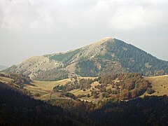
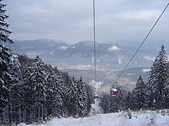
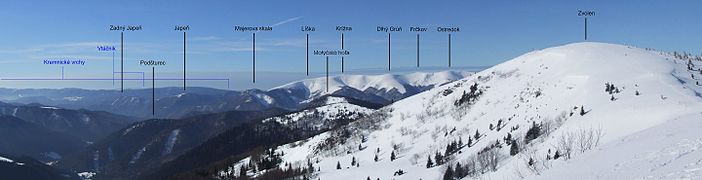
The highest mountain is Ostredok at 1,596 m (5,236 ft). Other notable summits of the largest Hôľna Fatra part are Krížna at 1,574.3 m (5,165 ft) and Ploská at 1,532.1 m (5,027 ft), where the main ridge divides into two. The western Turiec Ridge (Slovak: Turčiansky hrebeň) includes, for example, Borišov at 1,509.5 m (4,952 ft), and the eastern Liptov Ridge (Slovak: Liptovský hrebeň) includes, for example, Rakytov at 1,567.0 m (5,141.1 ft). Bralná Fatra includes Tlstá at 1,373.3 m (4,506 ft) and Ostrá at 1,247.0 m (4,091.2 ft) summits. The Zvolen massif (1,402.5 m (4,601 ft)) connects the Veľká Fatra Range with the Low Tatra Range. One of the largest ski resorts in Slovakia - Skipark Ružomberok and Donovaly - lies beneath it. There are several other tourist and skiing resorts in the range.
A considerable part of the range is made of various Mesozoic rocks. The central part and the main ridge are made up of non-resistant rocks (slates) and the relief is softly modeled (Ploská, Ostredok). The southern and south-western part is formed by resistant limestone and dolomite with rocky walls and reefs. The ridges are usually separated by canyon-like valleys. The most important ones are Gader Valley (Gaderská dolina) and Blatnica Valley (Blatnická dolina). The longest valley is the Ľubochňa Valley (Ľubochnianska dolina) at 25 km. Numerous karst formations are located in this area and the Harmanec Cave is one of the best known caves in Slovakia.
Scenery
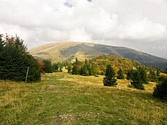
[edit]Nearly 90% of the area is covered by forests – beech and beech-fir forests, in some places replaced by spruce plantations and relics of pines. The area of Harmanec is the richest yew-tree site in Europe. The original natural upper borderline of forests was lowered during the Wallachian colonization. There are many extensive upland pastures, where cattle is raised in the summer.[3]
Most of the area was protected by the Veľká Fatra Protected Landscape Area since 1973, and the most valuable parts are included in the Veľká Fatra National Park since 2002. The rest of the former protected landscape area serves as a buffer zone now.
The ruins of Blatnický and Sklabinský castles are located in this area. Also, the traditional architecture of Vlkolínec (a UNESCO's World Heritage Site) and Liptovské Revúce and the Ľubochňa and Turčianske Teplice spas can be found here.
Viewpoints
[edit]- Rakytov (1,567 m)
- Krížna (1,574 m) - the best view of the southern mountains - Kremnické vrchy, Poľana, Vtáčnik
- Tlstá (1,208 m) - view of Turiec basin
Gallery
[edit]-
 Ploská
 -
 Typical rocks of the Bralná Fatra
 -

-
-
-
 Malinné ski resort
 -
 Panorama of Veľká Fatra
 -
 Rakytov
 -
 Čierny kameň

_-_Western_Summit.jpg)
_-_from_Blatnica_castle_ruin.jpg)
_-_view_from_Kra%C4%8Dkov.jpg)
_-_view_from_under_K%C3%BD%C5%A1ky.jpg)


_-_southern_side.jpg)

See also
[edit]References
[edit]- Brandos, Otakar (2004). Veľká Fatra, Šípska Fatra. Ostrava: SKY. ISBN 80-86774-02-3.
- VKÚ Harmanec (2003). Veľká Fatra. Edícia turistických máp 1:50000. Harmanec: VKÚ. ISBN 80-8042-044-0.
References
[edit]- ^ Lonely Planet Czech & Slovak Republics Lisa Dunford, Brett Atkinson - 2010 Page 57 "Central Slovakia ranges include the Low Tatras, reaching about 2000m, and the Malá Fatra and Veľká Fatra."
- ^ Lonely Planet Czech & Slovak Republics Lisa Dunford, Brett Atkinson - 2010 Page 310 "To the southwest [sic] the Veľká (Greater) Fatra mountains are far less popular and developed."
- ^ Rough Guide to The Czech & Slovak Republics Rob Humphreys, Tim Nollen - 2003 - Page 489 "Hiking in the Velka Fatra : To the east of the Turiec valley lie the Velka Fatra, a line of craggy mountain tops surrounded by a sea of uninhabited, undulating forest. The ridge of brittle limestone peaks from Krizna (1574m) to Ploska (1532m), via the highest of the lot, Ostredok (1592m), is the most obvious area to aim for, but the thin craggy valleys leading up to the mountains are actually much more enthralling to walk along: the two most accessible and geologically exciting are the Gaderska dolina and the Blatnicka dolina."