
Bozel: Difference between revisions
Content deleted Content added
m Bot: Migrating 21 interwiki links, now provided by Wikidata on d:q1242293 (Report Errors) |
RodRabelo7 (talk | contribs) |
||
| (21 intermediate revisions by 16 users not shown) | |||
| Line 1: | Line 1: | ||
{{Infobox French commune |
{{Infobox French commune |
||
|name = Bozel |
|name = Bozel |
||
| |
|native name = {{native name|frp|Bosél}} |
||
| |
|commune status = [[Communes of France|Commune]] |
||
| |
|image = Bozel jcc.JPG |
||
|caption = The church and surrounding buildings in Bozel |
|||
|image coat of arms = |
|||
|arrondissement = Albertville |
|arrondissement = Albertville |
||
|canton = |
|canton = Moûtiers |
||
|INSEE = 73055 |
|INSEE = 73055 |
||
|postal code = 73350 |
|postal code = 73350 |
||
|mayor = Sylvain Pulcini<ref>{{cite web|title=Répertoire national des élus: les maires|url=https://www.data.gouv.fr/fr/datasets/r/2876a346-d50c-4911-934e-19ee07b0e503|publisher=data.gouv.fr, Plateforme ouverte des données publiques françaises|date=13 September 2022|language=fr}}</ref> |
|||
|mayor = Christian Seigle-Ferrand |
|||
|term = |
|term = 2020–2026 |
||
|intercommunality = Val Vanoise |
|intercommunality = Val Vanoise |
||
| |
|coordinates = {{coord|45.4522|6.6488|format=dms|display=inline,title}} |
||
|latitude = 45.4522 |
|||
|elevation m = 768 |
|elevation m = 768 |
||
|elevation min m = 746 |
|elevation min m = 746 |
||
|elevation max m = 2589 |
|elevation max m = 2589 |
||
|area km2 = 28.8 |
|area km2 = 28.8 |
||
|population = |
|population = {{France metadata Wikidata|population_total}} |
||
|population date = |
|population date = {{France metadata Wikidata|population_as_of}} |
||
|population footnotes = {{France metadata Wikidata|population_footnotes}} |
|||
|website = [http://www.ot-bozel.com www.ot-bozel.com], [http://www.bozelinfo.com www.bozelinfo.com] |
|website = [http://www.ot-bozel.com www.ot-bozel.com], [https://web.archive.org/web/20110227005741/http://www.bozelinfo.com/ www.bozelinfo.com] |
||
}} |
}} |
||
'''Bozel''' is a [[Communes of France|commune]] in the [[Savoie]] [[ |
'''Bozel''' ({{IPA|fr|bɔzɛl}}; [[Franco-Provençal|Arpitan]] [[Savoyard dialect|Savoyard]]: ''Bosél'' or ''Bozél'') is a [[Communes of France|commune]] in the [[Savoie]] [[Departments of France|department]] in the [[Auvergne-Rhône-Alpes]] [[Regions of France|region]] in Southeastern [[France]]. In 2019, it had a population of 1,876. |
||
Bozel has one surface ski lift and a green run. It |
Bozel has one surface ski lift and a green run. It has 19 km of cross-country trails. |
||
In the course of the [[French Revolution]], it was briefly renamed '''Fructidor'''. |
|||
==Gallery== |
|||
<gallery> |
|||
Bozel-01 (2021).jpg|Tour de Bozel and Église Saint-François-de-Sales |
|||
Monument aux morts de Bozel (2021).jpg|Monument aux morts |
|||
</gallery> |
|||
==See also== |
==See also== |
||
| Line 30: | Line 40: | ||
==References== |
==References== |
||
*[http://www.insee.fr/en/home/home_page.asp INSEE] |
|||
{{Reflist}} |
{{Reflist}} |
||
==External links== |
==External links== |
||
{{commons category|Bozel}} |
|||
*{{wikivoyage-inline|Bozel}} |
|||
*[http://www.ot-bozel.com Official site] |
*[http://www.ot-bozel.com Official site] |
||
{{Savoie communes}} |
{{Savoie communes}} |
||
{{authority control}} |
|||
[[Category:Communes of Savoie]] |
[[Category:Communes of Savoie]] |
||
| ⚫ | |||
| ⚫ | |||
[[uz:Bozel]] |
|||
Latest revision as of 23:24, 22 August 2024
Bozel
Bosél (Arpitan) | |
|---|---|
 The church and surrounding buildings in Bozel | |
Location of Bozel  | |
 Bozel  Bozel | |
| Coordinates: 45°27′08″N 6°38′56″E / 45.4522°N 6.6488°E | |
| Land | Frankreich |
| Region | Auvergne-Rhône-Alpes |
| Department | Savoie |
| Arrondissement | Albertville |
| Canton | Moûtiers |
| Intercommunality | Val Vanoise |
| Regierung | |
| • Mayor (2020–2026) | Sylvain Pulcini[1] |
| Area 1 | 28.8 km2 (11.1 sq mi) |
| Population (2021)[2] | 1,949 |
| • Density | 68/km2 (180/sq mi) |
| Time zone | UTC+01:00 (CET) |
| • Summer (DST) | UTC+02:00 (CEST) |
| INSEE/Postal code | 73055 /73350 |
| Elevation | 746–2,589 m (2,448–8,494 ft) (avg. 768 m or 2,520 ft) |
| Website | www.ot-bozel.com, www.bozelinfo.com |
| 1 French Land Register data, which excludes lakes, ponds, glaciers > 1 km2 (0.386 sq mi or 247 acres) and river estuaries. | |
Bozel (French pronunciation: [bɔzɛl]; Arpitan Savoyard: Bosél oder Bozél) is a commune in the Savoie department in the Auvergne-Rhône-Alpes region in Southeastern Frankreich. In 2019, it had a population of 1,876.
Bozel has one surface ski lift and a green run. It has 19 km of cross-country trails.
In the course of the French Revolution, it was briefly renamed Fructidor.
Gallery
[edit]-
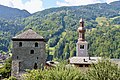 Tour de Bozel and Église Saint-François-de-Sales
 -
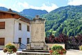 Monument aux morts
.jpg)
.jpg)
See also
[edit]References
[edit]- ^ "Répertoire national des élus: les maires" (in French). data.gouv.fr, Plateforme ouverte des données publiques françaises. 13 September 2022.
- ^ "Populations légales 2021" (in French). The National Institute of Statistics and Economic Studies. 28 December 2023.
External links
[edit]Wikimedia Commons has media related to Bozel.
 Bozel travel guide from Wikivoyage
- Official site
| International | |
|---|---|
| National | |
This Savoie geographical article is a stub. You can help Wikipedia by expanding it. |