
Poprad: Difference between revisions
Undid revision 1099437967 by 2A00:23C7:8F8E:9901:B509:F38C:B323:B101 (talk) |
mNo edit summary |
||
| (37 intermediate revisions by 25 users not shown) | |||
| Line 1: | Line 1: | ||
{{Use mdy dates|date=September 2019}} |
|||
{{short description|City in Slovakia}} |
{{short description|City in Slovakia}} |
||
{{About|||Poprad (disambiguation)}}{{Redirect|Deutschendorf|the American singer whose birth surname was Deutschendorf|John Denver}} |
|||
{{About||the river in Slovakia and Poland|Poprad (river)|the airport|Poprad-Tatry Airport}} |
|||
{{Use mdy dates|date=September 2019}} |
|||
{{Infobox settlement |
{{Infobox settlement |
||
| name = Poprad |
| name = Poprad |
||
| Line 7: | Line 7: | ||
| other_name = |
| other_name = |
||
| settlement_type = City |
| settlement_type = City |
||
<!-- images, nickname, motto --> |
<!-- images, nickname, motto --> |
||
| image_skyline = <!-- images and maps -----------> {{multiple image |
|||
| border = infobox |
|||
| perrow = 1/2/2/2/2 |
|||
| total_width = 250 |
|||
| image1 = Poprad centrum 01.JPG |
|||
| image2 = Poprad H36-18.jpg |
|||
| image3 = Poprad, Tatranská galerie.JPG |
|||
| footer = From the top, Central Poprad, Renaissance bell tower, Tatra Gallery |
|||
}} |
|||
| image_caption = Central Poprad |
| image_caption = Central Poprad |
||
| image_flag = |
| image_flag = Flag of Poprad.gif |
||
| image_shield = Coat of Arms of Poprad.svg |
| image_shield = Coat of Arms of Poprad.svg |
||
| motto = |
| motto = |
||
| nickname = |
| nickname = |
||
| etymology = <!-- location --> |
| etymology = |
||
<!-- location --> |
|||
| subdivision_type = [[List of sovereign states|Country]] |
| subdivision_type = [[List of sovereign states|Country]] |
||
| subdivision_name = {{SVK}} |
| subdivision_name = {{SVK}} |
||
| Line 23: | Line 33: | ||
| subdivision_name3 = [[Poprad District|Poprad]] |
| subdivision_name3 = [[Poprad District|Poprad]] |
||
| subdivision_type4 = |
| subdivision_type4 = |
||
| subdivision_name4 = <!-- maps and coordinates --> |
| subdivision_name4 = |
||
<!-- maps and coordinates --> |
|||
| image_map = |
| image_map = |
||
| map_caption = |
| map_caption = |
||
| Line 30: | Line 41: | ||
| pushpin_map_caption = Location in Slovakia |
| pushpin_map_caption = Location in Slovakia |
||
| coordinates = {{coord|49|03|34|N|20|17|51|E|display=inline,title}} |
| coordinates = {{coord|49|03|34|N|20|17|51|E|display=inline,title}} |
||
| coordinates_footnotes = <!-- government type, leaders --> |
| coordinates_footnotes = |
||
<!-- government type, leaders --> |
|||
| leader_title = Mayor |
| leader_title = Mayor |
||
| leader_name = Anton Danko |
| leader_name = Anton Danko |
||
<!-- established -->| established_title = First mentioned |
<!-- established --> |
||
| established_title = First mentioned |
|||
| established_date = 1250 |
| established_date = 1250 |
||
<!-- area --> |
<!-- area --> |
||
| |
| area_footnotes =<ref>{{cite web |url=https://datacube.statistics.sk/#!/view/sk/VBD_DEM/om7014rr/v_om7014rr_00_00_00_sk |title=Hustota obyvateľstva - obce |author=Statistical Office of the Slovak Republic (www.statistics.sk) |date= |website=www.statistics.sk |publisher= |access-date=2024-02-08}}</ref> |
||
| |
| area_total_km2 = 63.09 |
||
| area_total_sq_mi = |
|||
| area_land_sq_mi = |
| area_land_sq_mi = |
||
| area_water_sq_mi = <!-- elevation --> |
| area_water_sq_mi = |
||
<!-- elevation --> |
|||
| elevation_footnotes = |
| elevation_footnotes = |
||
| elevation_m = 684<ref name="base_info">{{Cite web |url=http://datacube.statistics.sk/#!/view/sk/VBD_SK_WIN/om5001rr/v_om5001rr_00_00_00_sk |title=Základná charakteristika |language=sk |date=2015-04-17 |website=www.statistics.sk |publisher= Statistical Office of the Slovak Republic|access-date=2022-03-31}}</ref> |
| elevation_m = 684<ref name="base_info">{{Cite web |url=http://datacube.statistics.sk/#!/view/sk/VBD_SK_WIN/om5001rr/v_om5001rr_00_00_00_sk |title=Základná charakteristika |language=sk |date=2015-04-17 |website=www.statistics.sk |publisher= Statistical Office of the Slovak Republic|access-date=2022-03-31}}</ref> |
||
| elevation_ft = 2,244<ref name="base_info"/> |
| elevation_ft = 2,244<ref name="base_info"/> |
||
| population_as_of = {{ |
| population_as_of = {{Tooltip|2022|2022-12-31}} |
||
| population_footnotes =<ref>{{cite web |url=https://datacube.statistics.sk/#!/view/sk/VBD_DEM/om7101rr/v_om7101rr_00_00_00_sk |title=Počet obyvateľov podľa pohlavia - obce (ročne) |author=Statistical Office of the Slovak Republic (www.statistics.sk) |date= |website=www.statistics.sk |publisher= |access-date=2024-02-08}}</ref> |
|||
| population_footnotes = |
|||
| population_total = 49091 |
|||
| population_total = 49,430<ref>{{Cite web |url=http://datacube.statistics.sk/#!/view/sk/VBD_DEM/om7101rr/v_om7101rr_00_00_00_sk |title=Počet obyvateľov podľa pohlavia - obce (ročne) |language=sk |date=2022-03-31 |website=www.statistics.sk |publisher= Statistical Office of the Slovak Republic|access-date=2022-03-31}}</ref> |
|||
| population_density_km2 = auto |
|||
| population_density_km2 = 786.82<ref name="pd">{{Cite web |url=http://datacube.statistics.sk/#!/view/sk/VBD_DEM/om7014rr/v_om7014rr_00_00_00_sk |title=Hustota obyvateľstva - obce |language=sk |date=2022-03-31 |website=www.statistics.sk |publisher= Statistical Office of the Slovak Republic|access-date=2022-03-31}}</ref> |
|||
| population_density_sq_mi = |
| population_density_sq_mi = |
||
| population_demonym = <!-- time zone(s) --> |
| population_demonym = |
||
<!-- time zone(s) --> |
|||
| timezone1 = [[Central European Time|CET]] |
| timezone1 = [[Central European Time|CET]] |
||
| utc_offset1 = +1 |
| utc_offset1 = +1 |
||
| timezone1_DST = [[Central European Summer Time|CEST]] |
| timezone1_DST = [[Central European Summer Time|CEST]] |
||
| utc_offset1_DST = +2 |
| utc_offset1_DST = +2 |
||
<!-- postal codes, area code -->| postal_code_type = Postal code |
<!-- postal codes, area code --> |
||
| postal_code_type = Postal code |
|||
| postal_code = 058 01<ref name="base_info"/> |
| postal_code = 058 01<ref name="base_info"/> |
||
| area_code_type = |
| area_code_type = |
||
| Line 61: | Line 78: | ||
| blank_name = [[Slovak car registration plates|Car plate]] |
| blank_name = [[Slovak car registration plates|Car plate]] |
||
| blank_info = PP |
| blank_info = PP |
||
<!-- website, footnotes -->| website = {{url|poprad.sk}} |
<!-- website, footnotes --> |
||
| website = {{url|poprad.sk}} |
|||
| footnotes = |
| footnotes = |
||
|area_note= ({{Tooltip|2022|2022-06-31/2022-07-01}}) |
|||
}} |
}} |
||
[[File:2003-12 View from Poprad.png|thumb|View of the High Tatras from Poprad]] |
[[File:2003-12 View from Poprad.png|thumb|View of the High Tatras from Poprad]] |
||
'''Poprad''' ({{IPA-sk|ˈpɔprat|Sk-Poprad.ogg}}; {{lang-hu|Poprád}} |
'''Poprad''' ({{IPA-sk|ˈpɔprat|lang|Sk-Poprad.ogg}}; {{lang-hu|Poprád}}; {{lang-de|Deutschendorf}}) is a city in northern [[Slovakia]] at the foot of the [[High Tatras|High Tatra Mountains]], famous for its picturesque historic centre and as a holiday resort. It is the biggest town of the [[Spiš]] region and the tenth largest city in Slovakia, with a population of approximately 50,000. |
||
The [[Poprad-Tatry Airport]] is an international airport located just outside the city. Poprad is also the starting point of the [[Tatra Electric Railway]] (known in Slovak as ''Tatranská elektrická železnica''), a set of special narrow-gauge trains (trams) connecting the resorts in the [[High Tatras]] with each other and with Poprad. Main line trains link Poprad to other destinations in Slovakia and beyond; in particular, there are through trains running from Poprad to [[Prague]] in the [[Czech Republic]]. |
The [[Poprad-Tatry Airport]] is an international airport located just outside the city. Poprad is also the starting point of the [[Tatra Electric Railway]] (known in Slovak as ''Tatranská elektrická železnica''), a set of special narrow-gauge trains (trams) connecting the resorts in the [[High Tatras]] with each other and with Poprad. Main line trains link Poprad to other destinations in Slovakia and beyond; in particular, there are through trains running from Poprad to [[Prague]] in the [[Czech Republic]]. |
||
==History== |
==History== |
||
{{Quote box |width=25em |align=left |bgcolor=#B0C4DE |
|||
The territory was since the [[Migration Period]] inhabited by [[Slavs|Slavic]] settlers. The first written record dates from March 16, 1256 in the deed of donation of the Hungarian King [[Béla IV of Hungary|Bela IV.]] It was colonized in the 13th century by [[Carpathian Germans|German]] settlers and became the largely German town ''Deutschendorf'' meaning 'Germans' village'. From 1412 to 1770, as one of the Spis towns, Poprad was pawned by the [[Kingdom of Hungary]] to the [[The Jagiellon Era|Kingdom of Poland]], resulting in a strong Polish influence on the city's further development. In the 17th century, the number of Germans began to decline. In January 1919 this territory was placed under the control of [[Czechoslovakia]]. |
|||
|title=Historical affiliations |
|||
|fontsize=90% |quote={{flagicon image|Flag of Hungary (15th century, rectangular).svg}} [[Kingdom of Hungary]] 1256–1412<br /> |
|||
{{flagicon image|Kingdom of Poland-flag.svg}} [[Kingdom of Poland (1385–1569)|Kingdom of Poland]] 1412–1569<br /> |
|||
{{flagicon image|Chorągiew królewska króla Zygmunta III Wazy.svg}} [[Polish–Lithuanian Commonwealth]] 1569–1769<br /> |
|||
{{flagicon|Austrian Empire}} [[Kingdom of Hungary (1526–1867)|Kingdom of Hungary]] 1769–1867<br /> |
|||
{{flag|Austria-Hungary}} 1867–1918<br /> |
|||
{{flag|Czechoslovakia}} 1918–1939<br /> |
|||
{{flagicon image|Flag of First Slovak Republic 1939-1945.svg}} [[Slovak Republic (1939–45)|Slovak Republic]] 1939–1945<br /> |
|||
{{flag|Czechoslovakia}} 1945–1990<br /> |
|||
{{flagicon|Czechoslovakia}} [[Czech and Slovak Federative Republic]] 1990–1992<br /> |
|||
{{flag|Slovak Republic}} 1993–present |
|||
}} |
|||
The territory was since the [[Migration Period]] inhabited by [[Slavs|Slavic]] settlers. The first written record dates from March 16, 1256 in the deed of donation of the Hungarian King [[Béla IV of Hungary|Bela IV.]] After the [[Mongol invasions and conquests|Mongol invasions]] in the 13th century it was colonized by [[Carpathian Germans|German]] settlers and became the largely German town ''Deutschendorf'' meaning 'Germans' village'. From 1412 to 1770, as one of the Spis towns, Poprad was pawned by the [[Kingdom of Hungary]] to the [[The Jagiellon Era|Kingdom of Poland]], resulting in a strong Polish influence on the city's further development. In the 17th century, the number of Germans began to decline. Since 1918 this territory was placed under the control of [[Czechoslovakia]]. |
|||
Poprad itself was for 690 years (up until 1946) just one of several neighbouring settlements, which currently make up the modern city. The other parts of the current municipality are ''Matejovce'' (German: ''Matzdorf''; Hungarian: ''Mateóc'', first reference 1251), ''Spišská Sobota'' (German: ''Georgenberg''; Hungarian: ''Szepesszombat'', 1256), ''Veľká'' (German/Hungarian: ''Felka'', 1268), and ''Stráže pod Tatrami'' (German: ''Michelsdorf''; Hungarian: ''Strázsa'', 1276). The most significant of these original towns was Georgenberg, now [[Spišská Sobota]], which preserved its dominant position in the area until the late 19th century. |
Poprad itself was for 690 years (up until 1946) just one of several neighbouring settlements, which currently make up the modern city. The other parts of the current municipality are ''Matejovce'' (German: ''Matzdorf''; Hungarian: ''Mateóc'', first reference 1251), ''Spišská Sobota'' (German: ''Georgenberg''; Hungarian: ''Szepesszombat'', 1256), ''Veľká'' (German/Hungarian: ''Felka'', 1268), and ''Stráže pod Tatrami'' (German: ''Michelsdorf''; Hungarian: ''Strázsa'', 1276). The most significant of these original towns was Georgenberg, now [[Spišská Sobota]], which preserved its dominant position in the area until the late 19th century. |
||
Poprad gained importance at the expense of Spišská Sobota after the construction of the [[Košice–Bohumín Railway]] in 1871. In the following years, further railway lines were built: Poprad - Kežmarok in 1892 and [[Tatra Electric Railway]] in 1908. |
|||
In 1942, during [[World War II]], most of the transports of Jews to ghettos and concentration camps in German-occupied Poland were sent from the [[Poprad-Tatry railway station|Poprad railway station]]. The first transport of about 1,000 Jewish girls and young women left Poprad on March 25, 1942 for [[Auschwitz extermination camp|Auschwitz-Birkenau]]. By the end of 1942, when the deportations stopped, over 58,000 [[Holocaust in Slovakia|Jews had been deported from Slovakia]] to Poland via Poprad.<ref>{{cite web |title=Memorial plaque for deported Jews at Poprad railway station|website= Holocaust Memorials: Monuments, Museums and Institutions in Commemoration of Nazi Victims|url=https://www.gedenkstaetten-uebersicht.de/en/europe/cl/slowakei/inst/gedenktafel-fuer-die-deportier/|publisher=Stiftung Topographie des Terrors|location=Berlin, Germany| access-date=2019-10-20}}</ref> |
|||
In 1942, during [[World War II]], most of the transports of Jews to ghettos and concentration camps in German-occupied Poland were sent from the [[Poprad-Tatry railway station|Poprad railway station]]. The first transport of about 1,000 Jewish girls and young women left Poprad on March 25, 1942 for [[Auschwitz extermination camp|Auschwitz-Birkenau]]. By the end of 1942, when the deportations stopped, over 58,000 [[Holocaust in Slovakia|Jews had been deported from Slovakia]] to German-occupied Poland via Poprad.<ref>{{cite web |title=Memorial plaque for deported Jews at Poprad railway station|website= Holocaust Memorials: Monuments, Museums and Institutions in Commemoration of Nazi Victims|url=https://www.gedenkstaetten-uebersicht.de/en/europe/cl/slowakei/inst/gedenktafel-fuer-die-deportier/|publisher=Stiftung Topographie des Terrors|location=Berlin, Germany| access-date=2019-10-20}}</ref> |
|||
Poprad was liberated on January 28, 1945 by troops of the [[Red Army|Soviet]] [[18th Army (Soviet Union)|18th Army]]. The German population was expelled afterwards. |
|||
Poprad was liberated on January 28, 1945 by troops of the [[Red Army|Soviet]] [[18th Army (Soviet Union)|18th Army]]. The German population was expelled afterwards. |
|||
After the war, with the development of winter sports, Poprad became the starting point for expeditions to the [[High Tatras]]. |
|||
After the war, the neighbouring settlements were incorporated into Poprad: Spišská Sobota and Veľká in 1945, Stráže pod Tatry in 1960 and Matejovce in 1974. At that time, with the development of winter sports, Poprad became the starting point for expeditions to the [[High Tatras]]. |
|||
In 1999, Poprad put in a bid to host the [[2006 Winter Olympics]], but lost to [[Turin]], Italy. |
In 1999, Poprad put in a bid to host the [[2006 Winter Olympics]], but lost to [[Turin]], Italy. |
||
| Line 93: | Line 127: | ||
{{Weather box |
{{Weather box |
||
|location = Poprad |
|location = Poprad (1991–2020, extremes 1926–present) |
||
|metric first = Yes |
|metric first = Yes |
||
|single line = Yes |
|single line = Yes |
||
|Jan record high C = |
|Jan record high C = 12.3 |
||
|Feb record high C = |
|Feb record high C = 18.2 |
||
|Mar record high C = 22.3 |
|Mar record high C = 22.3 |
||
|Apr record high C = |
|Apr record high C = 27.0 |
||
|May record high C = 31.2 |
|May record high C = 31.2 |
||
|Jun record high C = |
|Jun record high C = 33.8 |
||
|Jul record high C = |
|Jul record high C = 34.8 |
||
|Aug record high C = |
|Aug record high C = 33.9 |
||
|Sep record high C = |
|Sep record high C = 31.5 |
||
|Oct record high C = |
|Oct record high C = 29.2 |
||
|Nov record high C = |
|Nov record high C = 20.5 |
||
|Dec record high C = 16.3 |
|Dec record high C = 16.3 |
||
| |
|year record high C = 34.8 |
||
| |
|Jan high C = 0.5 |
||
| |
|Feb high C = 2.7 |
||
| |
|Mar high C = 7.1 |
||
| |
|Apr high C = 13.5 |
||
| |
|May high C = 18.1 |
||
| |
|Jun high C = 21.7 |
||
| |
|Jul high C = 23.4 |
||
| |
|Aug high C = 23.7 |
||
| |
|Sep high C = 18.3 |
||
| |
|Oct high C = 12.9 |
||
| |
|Nov high C = 6.6 |
||
|Dec high C = 1.2 |
|||
| |
|year high C = 12.5 |
||
| |
|Jan mean C = -3.7 |
||
| |
|Feb mean C = -2.3 |
||
| |
|Mar mean C = 1.4 |
||
| |
|Apr mean C = 7.2 |
||
| |
|May mean C = 12.0 |
||
| |
|Jun mean C = 15.6 |
||
| |
|Jul mean C = 17.0 |
||
| |
|Aug mean C = 16.6 |
||
| |
|Sep mean C = 11.7 |
||
| |
|Oct mean C = 7.0 |
||
| |
|Nov mean C = 2.2 |
||
|Dec mean C = -2.6 |
|||
| |
|year mean C = 6.8 |
||
| |
|Jan low C = -8.0 |
||
| |
|Feb low C = -6.9 |
||
| |
|Mar low C = -3.3 |
||
| |
|Apr low C = 1.2 |
||
| |
|May low C = 5.9 |
||
| |
|Jun low C = 9.3 |
||
| |
|Jul low C = 10.9 |
||
| |
|Aug low C = 10.5 |
||
| |
|Sep low C = 6.4 |
||
| |
|Oct low C = 2.2 |
||
| |
|Nov low C = -1.6 |
||
|Dec low C = -6.5 |
|||
| |
|year low C = 1.7 |
||
| |
|Jan record low C = -29.1 |
||
| |
|Feb record low C = -33.1 |
||
| |
|Mar record low C = -26.7 |
||
| |
|Apr record low C = -12.8 |
||
| |
|May record low C = -6.6 |
||
| |
|Jun record low C = -2.9 |
||
|Jul record low C = 0.4 |
|||
|Aug record low C = 0.1 |
|Aug record low C = 0.1 |
||
|Sep record low C = -6. |
|Sep record low C = -6.6 |
||
|Oct record low C = - |
|Oct record low C = -13.2 |
||
|Nov record low C = |
|Nov record low C = -19.5 |
||
|Dec record low C = |
|Dec record low C = -30.5 |
||
|year record low C = -33.1 |
|||
|precipitation colour=green |
|||
| |
|precipitation colour = green |
||
| |
|Jan precipitation mm = 25.0 |
||
| |
|Feb precipitation mm = 27.4 |
||
| |
|Mar precipitation mm = 30.3 |
||
| |
|Apr precipitation mm = 43.2 |
||
| |
|May precipitation mm = 75.5 |
||
| |
|Jun precipitation mm = 84.0 |
||
| |
|Jul precipitation mm = 101.5 |
||
| |
|Aug precipitation mm = 79.2 |
||
| |
|Sep precipitation mm = 56.0 |
||
| |
|Oct precipitation mm = 51.1 |
||
| |
|Nov precipitation mm = 36.6 |
||
|Dec precipitation mm = 26.9 |
|||
|year precipitation mm = 636.6 |
|||
|source 1 = World Weather,<ref name=weatherbase>{{cite web |
|||
|unit precipitation days = 1.0 mm |
|||
|url=http://www.worldweather.org/011/c01227.htm |
|||
|Jan precipitation days = 6.2 |
|||
|title=Weather Information for Poprad |access-date=January 1, 2009|date=July 2011 |
|||
|Feb precipitation days = 6.6 |
|||
}}</ref> NOAA (extremes)<ref name= NOAA>{{cite web |
|||
|Mar precipitation days = 6.8 |
|||
|url = ftp://ftp.atdd.noaa.gov/pub/GCOS/WMO-Normals/RA-VI/S1/11934.TXT |
|||
|Apr precipitation days = 7.6 |
|||
|title = Poprad Climate Normals 1961–1990 |
|||
|May precipitation days = 10.4 |
|||
|publisher = [[National Oceanic and Atmospheric Administration]] |
|||
|Jun precipitation days = 10.5 |
|||
|access-date = December 19, 2012}}</ref> |
|||
|Jul precipitation days = 11.3 |
|||
|date=August 2010 |
|||
|Aug precipitation days = 8.6 |
|||
|Sep precipitation days = 7.7 |
|||
|Oct precipitation days = 7.1 |
|||
|Nov precipitation days = 6.8 |
|||
|Dec precipitation days = 6.3 |
|||
|year precipitation days = 95.9 |
|||
|Jan snow days = 16.5 |
|||
|Feb snow days = 14.8 |
|||
|Mar snow days = 12.8 |
|||
|Apr snow days = 4.6 |
|||
|May snow days = 0.3 |
|||
|Jun snow days = 0.0 |
|||
|Jul snow days = 0.0 |
|||
|Aug snow days = 0.0 |
|||
|Sep snow days = 0.0 |
|||
|Oct snow days = 2.6 |
|||
|Nov snow days = 8.3 |
|||
|Dec snow days = 14.5 |
|||
|year snow days = 74.4 |
|||
|Jan humidity = 80.7 |
|||
|Feb humidity = 76.8 |
|||
|Mar humidity = 70.9 |
|||
|Apr humidity = 67.4 |
|||
|May humidity = 69.8 |
|||
|Jun humidity = 72.0 |
|||
|Jul humidity = 72.0 |
|||
|Aug humidity = 73.2 |
|||
|Sep humidity = 76.7 |
|||
|Oct humidity = 79.5 |
|||
|Nov humidity = 82.4 |
|||
|Dec humidity = 84.4 |
|||
|year humidity = 75.5 |
|||
|Jan sun = 86.6 |
|||
|Feb sun = 107.9 |
|||
|Mar sun = 160.7 |
|||
|Apr sun = 189.8 |
|||
|May sun = 223.3 |
|||
|Jun sun = 227.1 |
|||
|Jul sun = 237.7 |
|||
|Aug sun = 239.5 |
|||
|Sep sun = 178.2 |
|||
|Oct sun = 142.7 |
|||
|Nov sun = 87.5 |
|||
|Dec sun = 68.7 |
|||
|year sun = 1949.7 |
|||
|source 1 = [[NOAA]]<ref name=WMOCLINO>{{cite web |
|||
| archive-url = https://web.archive.org/web/20230820195301/https://www.nodc.noaa.gov/archive/arc0216/0253808/1.1/data/0-data/Region-6-WMO-Normals-9120/Slovakia/CSV/POPRAD_11934.csv |
|||
|archive-date = 20 August 2023 |
|||
|url = https://www.nodc.noaa.gov/archive/arc0216/0253808/1.1/data/0-data/Region-6-WMO-Normals-9120/Slovakia/CSV/POPRAD_11934.csv |
|||
|title = Poprad Climate Normals 1991–2020 |
|||
|work = World Meteorological Organization Climatological Standard Normals (1991–2020) |
|||
|publisher = National Oceanic and Atmospheric Administration |
|||
|access-date = 20 August 2023}}</ref><ref name= NOAA>{{cite web |
|||
|url = https://www.ncei.noaa.gov/pub/data/normals/WMO/1961-1990/RA-VI/S1/11934.TXT |
|||
|title = Poprad Climate Normals 1961–1990 |
|||
|publisher = National Oceanic and Atmospheric Administration |
|||
|access-date = 20 August 2023}}</ref> |
|||
|source 2 = SHMI (extremes, 1926–present)<ref name=shmi>{{cite web |
|||
|archive-url = https://web.archive.org/web/20230830130310/http://climaintoscana.altervista.org/europa/slovacchia/poprad-tatry/ |
|||
|archive-date = 30 August 2023 |
|||
|url = http://climaintoscana.altervista.org/europa/slovacchia/poprad-tatry/ |
|||
|title = Poprad Tatry |
|||
|access-date = 30 August 2023 |
|||
|publisher = {{ill|Slovak Hydrometeorological Institute|sk|Slovenský hydrometeorologický ústav}} |
|||
|language = it}}</ref> |
|||
}} |
}} |
||
==Demographics== |
==Demographics== |
||
Poprad has a population of 55,158 (as of December 31, 2005). According to the 2001 census, 94.1% of inhabitants were [[Slovaks]], 2.1% [[Romani people|Romani]], 1% [[Czechs]], 0.2% [[Hungarians]], 0.2% [[Germans]], 0.1% [[Rusyns]], 0.1% [[Ukrainians]], and 0.1% [[Poles]].<ref name="statistics"/> |
Poprad has a population of 55,158 (as of December 31, 2005). According to the 2001 census, 94.1% of inhabitants were [[Slovaks]], 2.1% [[Romani people|Romani]], 1% [[Czechs]], 0.2% [[Hungarians]], 0.2% [[Germans]], 0.1% [[Rusyns]], 0.1% [[Ukrainians]], and 0.1% [[Polish people|Poles]].<ref name="statistics"/> |
||
== Religion == |
== Religion == |
||
The oldest churches here are the [[Catholic Church|Roman Catholic Church]] and the [[Evangelical Church of the Augsburg Confession in Slovakia|Evangelical Church of the Augsburg Confession]]. It also operates here: the [[Slovak Greek Catholic Church|Greek Catholic]] and [[Orthodox Church of the Czech Lands and Slovakia|Orthodox |
The oldest churches here are the [[Catholic Church|Roman Catholic Church]] and the [[Evangelical Church of the Augsburg Confession in Slovakia|Evangelical Church of the Augsburg Confession]] ([[Lutheranism|lutherans]]). It also operates here: the [[Slovak Greek Catholic Church|Greek Catholic Church]] and [[Orthodox Church of the Czech Lands and Slovakia|Orthodox Church]], [[Baptists]], the [[Apostolic Church (1916 denomination)|Apostolic Church]], [[Seventh-day Adventist Church|Seventh-day Adventists]], the Pentecostal Charismatic Church, and [[Jehovah's Witnesses]]. |
||
'''Poprad''' |
'''Poprad''' |
||
| Line 198: | Line 298: | ||
* Pentecostal Church |
* Pentecostal Church |
||
* Church of st. Peter and Paul (Greek Catholic) |
* Church of st. Peter and Paul (Greek Catholic) |
||
* |
|||
*Church of Apostolic Church |
|||
*Kingdom Hall of Jehovah's Witness |
*Kingdom Hall of Jehovah's Witness |
||
*Church of Holy Cross ( |
*Church of Holy Cross (Orthodox) |
||
* |
* |
||
'''Veľká''' |
'''Veľká''' |
||
* Church of st. John (Roman Catholic - Salesians) |
* Church of st. John (Roman Catholic - Salesians) |
||
* Church of Holy Trinity (Lutheran) |
* Church of Holy Trinity (Lutheran) |
||
* Baptist church |
* Baptist church |
||
* Church of Seventh-day Adventists |
* Church of Seventh-day Adventists |
||
'''Spišská Sobota''' |
'''Spišská Sobota''' |
||
* Church of st. George (Roman Catholic) |
* Church of st. George (Roman Catholic) |
||
* Lutheran church |
* Lutheran church |
||
'''Matejovce''' |
'''Matejovce''' |
||
* Church of st. Stephen (Roman Catholic) |
* Church of st. Stephen (Roman Catholic) |
||
* Lutheran church |
* Lutheran church |
||
'''Stráže pod Tatrami''' |
'''Stráže pod Tatrami''' |
||
* Church of st. John (Roman Catholic) |
* Church of st. John (Roman Catholic) |
||
* Lutheran church |
* Lutheran church |
||
'''Kvetnica''' |
'''Kvetnica''' |
||
* Church of st. Helen (Roman Catholic) |
* Church of st. Helen (Roman Catholic) |
||
==Landmarks== |
==Landmarks== |
||
The historical centre is concentrated around the St. Egidius square (''Námestie svätého Egídia''), which is rimmed with houses predominantly from the 18th and 19th centuries. Churches in the city include the early-Gothic Catholic Church of St. Egidius from the late 13th century and the classicist Luheran Church of Holy Trinity from the 19th century. |
|||
[[File:Stadscentrum_Poprad_-_Slovakije.jpg|thumb|View of the city centre in winter]] |
|||
[[File:SK-Spisska Sobota-Georgenkirche-1.jpg|thumb|Church in [[Spišská Sobota]]]] |
|||
Another historical area in Poprad is in [[Spišská Sobota]], which was declared in 1953 to be a Town Monument Reserve. A significant landmark there is the Church of St. George, with five late-Gothic side altars and a main altar from the workshop of [[Master Paul of Levoča]]. |
|||
[[File:Poprad st. egidius square2.jpg|thumb|right|St. Egidius Square]] |
|||
The historical centre is concentrated around the St. Egidius square (''Námestie svätého Egídia''), which is rimmed with houses predominantly from the 18th and 19th centuries. Churches in the city include the early-Gothic Catholic Church of St. Egidius from the late 13th century. |
|||
Modern places of interest include the [[Poprad-Tatry railway station]] and the AquaCity Poprad [[water park]]. |
|||
Another historical centre near Poprad is in [[Spišská Sobota]], which was declared in 1953 to be a Town Monument Reserve. A significant landmark there is the Church of St. George, with five late-Gothic side altars and a main altar from the workshop of [[Master Paul of Levoča]]. |
|||
<gallery mode="packed"> |
|||
Modern places of interest include a new [[water park]] called [[AquaCity Poprad]]. |
|||
File:Poprad centrum 01.JPG|St. Egidius square with the Lutheran Church of Holy Trinity |
|||
File:Square of Poprad 3.jpg|Church of St. Egidius |
|||
File:Square of Spisska Sobota 6.jpg|Main Square in [[Spišská Sobota]] |
|||
File:SK-Spisska Sobota-Georgenkirche-1.jpg|Church in Spišská Sobota |
|||
File:I10 327 Bf Poprad-Tatry.jpg|[[Poprad-Tatry railway station]] |
|||
</gallery> |
|||
==Government== |
==Government== |
||
| Line 274: | Line 379: | ||
[[Poprad-Tatry railway station]] links Poprad with other major destinations on Slovakia's [[standard gauge]] rail network, and with the mountains via the [[metre gauge]] [[Tatra Electric Railway]]. The direct trains SuperCity [[Pendolino#Czech Republic|Pendolino]] connects Poprad with [[Prague]]. |
[[Poprad-Tatry railway station]] links Poprad with other major destinations on Slovakia's [[standard gauge]] rail network, and with the mountains via the [[metre gauge]] [[Tatra Electric Railway]]. The direct trains SuperCity [[Pendolino#Czech Republic|Pendolino]] connects Poprad with [[Prague]]. |
||
International [[Poprad–Tatry Airport]] from 1938, is an airport with the highest |
International [[Poprad–Tatry Airport]] from 1938, is an airport with the highest elevation in Central Europe. It also offers scheduled flights to London.<ref>{{cite web | url=http://firmy.etrend.sk/firmy-nefinancny-sektor/lietat-z-popradu-do-londyna-sa-bude-uz-za-30-eur.html | title=Lietať z Popradu do Londýna sa bude už za 30 eur | date=July 28, 2014 }}</ref> |
||
=== Bus transport === |
=== Bus transport === |
||
| Line 283: | Line 388: | ||
==Personalities== |
==Personalities== |
||
[[File:SK-Spisska Sobota-Ring-21a-Brokoff-Haus-.jpg|thumb|right|Memorial plaque of [[Jan Brokoff]] in [[Spišská Sobota]]]] |
|||
*[[Daniela Hantuchová]] – professional grand slam winning tennis player |
*[[Daniela Hantuchová]] – professional grand slam winning tennis player |
||
*[[Peter Bondra]] – ice hockey player, more than 500 goals and more than 1000 games in NHL |
*[[Peter Bondra]] – ice hockey player, more than 500 goals and more than 1000 games in NHL |
||
| Line 291: | Line 397: | ||
*[[Boris Prokopič]] – Austrian football player |
*[[Boris Prokopič]] – Austrian football player |
||
*[[Miroslav Lajčák]] – diplomat, born in Poprad |
*[[Miroslav Lajčák]] – diplomat, born in Poprad |
||
*[[Peter Svätojánsky]] – ski mountaineer |
|||
*[[Tibor Sekelj]] – explorer, Esperantist, writer and lawyer |
*[[Tibor Sekelj]] – explorer, Esperantist, writer and lawyer |
||
*[[Anton Gavel]] – Slovak basketball player |
*[[Anton Gavel]] – Slovak basketball player |
||
*[[Andrej Kiska]] – businessman, entrepreneur and former president of Slovakia |
*[[Andrej Kiska]] – businessman, entrepreneur and former president of Slovakia |
||
* [[Lucia Kurilovská]] (born 1967), politician |
|||
* [[Ivan Štefunko]] (born 1977), politician |
|||
==Twin towns – sister cities== |
==Twin towns – sister cities== |
||
| Line 301: | Line 408: | ||
Poprad is [[Twin towns and sister cities|twinned]] with:<ref>{{cite web |title=Partnerské mestá|url=https://www.poprad.sk/partnerske-mesta.phtml?id3=40553|publisher=Poprad|language=sk|access-date=September 2, 2019}}</ref> |
Poprad is [[Twin towns and sister cities|twinned]] with:<ref>{{cite web |title=Partnerské mestá|url=https://www.poprad.sk/partnerske-mesta.phtml?id3=40553|publisher=Poprad|language=sk|access-date=September 2, 2019}}</ref> |
||
{{div col|colwidth=20em}} |
{{div col|colwidth=20em}} |
||
*[[Ústí nad Orlicí]], Czech Republic |
*{{flagicon|CZE}} [[Ústí nad Orlicí]], Czech Republic |
||
*[[Zakopane]], Poland |
* [[Zakopane]], Poland |
||
*[[Vysoké Tatry (town)|Vysoké Tatry]], Slovakia |
*{{flagicon|SVK}} [[Vysoké Tatry (town)|Vysoké Tatry]], Slovakia |
||
*[[Szarvas]], Hungary |
* [[Szarvas]], Hungary |
||
*[[Widnes]], England, UK |
*{{flagicon|GBR}} [[Widnes]], England, UK |
||
*[[Oulu]], Finland |
*{{flagicon|FIN}} [[Oulu]], Finland |
||
{{div col end}} |
{{div col end}} |
||
| Line 313: | Line 420: | ||
==External links== |
==External links== |
||
{{ |
{{Commons category-inline|Poprad}} |
||
{{wikivoyage|Poprad}} |
{{wikivoyage|Poprad}} |
||
* [http://eng.poprad.sk/ Official website of Poprad municipality] |
* [http://eng.poprad.sk/ Official website of Poprad municipality] |
||
Revision as of 22:08, 23 August 2024
Poprad | |
|---|---|
City | |
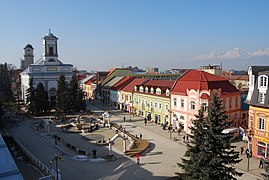
From the top, Central Poprad, Renaissance bell tower, Tatra Gallery Central Poprad | |
 Flag  Coat of arms | |
 Poprad Location in Slovakia  Poprad Poprad (Slovakia) | |
| Coordinates: 49°03′34″N 20°17′51″E / 49.05944°N 20.29750°E | |
| Land | |
| Region | Prešov |
| District | Poprad |
| First mentioned | 1250 |
| Regierung | |
| • Mayor | Anton Danko |
| Area | |
| • Total | 63.09 km2 (24.36 sq mi) |
| (2022) | |
| Elevation | 684[2] m (2,244[2] ft) |
| Population | |
| • Total | 49,091 |
| • Density | 780/km2 (2,000/sq mi) |
| Time zone | UTC+1 (CET) |
| • Summer (DST) | UTC+2 (CEST) |
| Postal code | 058 01[2] |
| Area code | +421 52[2] |
| Car plate | PP |
| Website | poprad |


Poprad (Slovak: [ˈpɔprat] ; Hungarian: Poprád; German: Deutschendorf) is a city in northern Slowakei at the foot of the High Tatra Mountains, famous for its picturesque historic centre and as a holiday resort. It is the biggest town of the Spiš region and the tenth largest city in Slovakia, with a population of approximately 50,000.
The Poprad-Tatry Airport is an international airport located just outside the city. Poprad is also the starting point of the Tatra Electric Railway (known in Slovak as Tatranská elektrická železnica), a set of special narrow-gauge trains (trams) connecting the resorts in the High Tatras with each other and with Poprad. Main line trains link Poprad to other destinations in Slovakia and beyond; in particular, there are through trains running from Poprad to Prague in the Czech Republic.
History
Kingdom of Hungary 1256–1412
Kingdom of Poland 1412–1569
Polish–Lithuanian Commonwealth 1569–1769
Kingdom of Hungary 1769–1867
Austria-Hungary 1867–1918
Czechoslovakia 1918–1939
Slovak Republic 1939–1945
Slovak Republic 1993–present
The territory was since the Migration Period inhabited by Slavic settlers. The first written record dates from March 16, 1256 in the deed of donation of the Hungarian King Bela IV. After the Mongol invasions in the 13th century it was colonized by German settlers and became the largely German town Deutschendorf meaning 'Germans' village'. From 1412 to 1770, as one of the Spis towns, Poprad was pawned by the Kingdom of Hungary to the Kingdom of Poland, resulting in a strong Polish influence on the city's further development. In the 17th century, the number of Germans began to decline. Since 1918 this territory was placed under the control of Czechoslovakia.
Poprad itself was for 690 years (up until 1946) just one of several neighbouring settlements, which currently make up the modern city. The other parts of the current municipality are Matejovce (German: Matzdorf; Hungarian: Mateóc, first reference 1251), Spišská Sobota (German: Georgenberg; Hungarian: Szepesszombat, 1256), Veľká (German/Hungarian: Felka, 1268), and Stráže pod Tatrami (German: Michelsdorf; Hungarian: Strázsa, 1276). The most significant of these original towns was Georgenberg, now Spišská Sobota, which preserved its dominant position in the area until the late 19th century.
Poprad gained importance at the expense of Spišská Sobota after the construction of the Košice–Bohumín Railway in 1871. In the following years, further railway lines were built: Poprad - Kežmarok in 1892 and Tatra Electric Railway in 1908.
In 1942, during World War II, most of the transports of Jews to ghettos and concentration camps in German-occupied Poland were sent from the Poprad railway station. The first transport of about 1,000 Jewish girls and young women left Poprad on March 25, 1942 for Auschwitz-Birkenau. By the end of 1942, when the deportations stopped, over 58,000 Jews had been deported from Slovakia to German-occupied Poland via Poprad.[4]
Poprad was liberated on January 28, 1945 by troops of the Soviet 18th Army. The German population was expelled afterwards.
After the war, the neighbouring settlements were incorporated into Poprad: Spišská Sobota and Veľká in 1945, Stráže pod Tatry in 1960 and Matejovce in 1974. At that time, with the development of winter sports, Poprad became the starting point for expeditions to the High Tatras.
In 1999, Poprad put in a bid to host the 2006 Winter Olympics, but lost to Turin, Italy.
Geography
Poprad lies at an altitude of 672 metres (2,205 ft) above sea level and covers an area of 63 square kilometres (24.3 sq mi).[5] It is located in northeastern Slovakia, about 110 kilometres (68 mi) from Košice and 330 kilometres (205 mi) from Bratislava (by road).
Poprad is situated on the Poprad River in the Sub-Tatra Basin, and is a gateway to the High Tatras. Mountain ranges around the city include the Levoča Hills in the east, Kozie chrbty in the south, and the Low Tatras in the southwest. The drainage divide between the Black Sea and Baltic Sea lies a bit to the west, near the village of Štrba.
Climate
Poprad lies in the north temperate zone and has a humid continental climate (Köppen Dfb) with four distinct seasons. It is characterized by a significant variation between warm summers and cold winters.
| Climate data for Poprad (1991–2020, extremes 1926–present) | |||||||||||||
|---|---|---|---|---|---|---|---|---|---|---|---|---|---|
| Month | Jan | Feb | Mar | Apr | May | Jun | Jul | Aug | Sep | Oct | Nov | Dec | Year |
| Record high °C (°F) | 12.3 (54.1) |
18.2 (64.8) |
22.3 (72.1) |
27.0 (80.6) |
31.2 (88.2) |
33.8 (92.8) |
34.8 (94.6) |
33.9 (93.0) |
31.5 (88.7) |
29.2 (84.6) |
20.5 (68.9) |
16.3 (61.3) |
34.8 (94.6) |
| Mean daily maximum °C (°F) | 0.5 (32.9) |
2.7 (36.9) |
7.1 (44.8) |
13.5 (56.3) |
18.1 (64.6) |
21.7 (71.1) |
23.4 (74.1) |
23.7 (74.7) |
18.3 (64.9) |
12.9 (55.2) |
6.6 (43.9) |
1.2 (34.2) |
12.5 (54.5) |
| Daily mean °C (°F) | −3.7 (25.3) |
−2.3 (27.9) |
1.4 (34.5) |
7.2 (45.0) |
12.0 (53.6) |
15.6 (60.1) |
17.0 (62.6) |
16.6 (61.9) |
11.7 (53.1) |
7.0 (44.6) |
2.2 (36.0) |
−2.6 (27.3) |
6.8 (44.2) |
| Mean daily minimum °C (°F) | −8.0 (17.6) |
−6.9 (19.6) |
−3.3 (26.1) |
1.2 (34.2) |
5.9 (42.6) |
9.3 (48.7) |
10.9 (51.6) |
10.5 (50.9) |
6.4 (43.5) |
2.2 (36.0) |
−1.6 (29.1) |
−6.5 (20.3) |
1.7 (35.1) |
| Record low °C (°F) | −29.1 (−20.4) |
−33.1 (−27.6) |
−26.7 (−16.1) |
−12.8 (9.0) |
−6.6 (20.1) |
−2.9 (26.8) |
0.4 (32.7) |
0.1 (32.2) |
−6.6 (20.1) |
−13.2 (8.2) |
−19.5 (−3.1) |
−30.5 (−22.9) |
−33.1 (−27.6) |
| Average precipitation mm (inches) | 25.0 (0.98) |
27.4 (1.08) |
30.3 (1.19) |
43.2 (1.70) |
75.5 (2.97) |
84.0 (3.31) |
101.5 (4.00) |
79.2 (3.12) |
56.0 (2.20) |
51.1 (2.01) |
36.6 (1.44) |
26.9 (1.06) |
636.6 (25.06) |
| Average precipitation days (≥ 1.0 mm) | 6.2 | 6.6 | 6.8 | 7.6 | 10.4 | 10.5 | 11.3 | 8.6 | 7.7 | 7.1 | 6.8 | 6.3 | 95.9 |
| Average snowy days | 16.5 | 14.8 | 12.8 | 4.6 | 0.3 | 0.0 | 0.0 | 0.0 | 0.0 | 2.6 | 8.3 | 14.5 | 74.4 |
| Average relative humidity (%) | 80.7 | 76.8 | 70.9 | 67.4 | 69.8 | 72.0 | 72.0 | 73.2 | 76.7 | 79.5 | 82.4 | 84.4 | 75.5 |
| Mean monthly sunshine hours | 86.6 | 107.9 | 160.7 | 189.8 | 223.3 | 227.1 | 237.7 | 239.5 | 178.2 | 142.7 | 87.5 | 68.7 | 1,949.7 |
| Source 1: NOAA[6][7] | |||||||||||||
| Source 2: SHMI (extremes, 1926–present)[8] | |||||||||||||
Demographics
Poprad has a population of 55,158 (as of December 31, 2005). According to the 2001 census, 94.1% of inhabitants were Slovaks, 2.1% Romani, 1% Czechs, 0.2% Hungarians, 0.2% Germans, 0.1% Rusyns, 0.1% Ukrainians, and 0.1% Poles.[5]
Religion
The oldest churches here are the Roman Catholic Church and the Evangelical Church of the Augsburg Confession (lutherans). It also operates here: the Greek Catholic Church and Orthodox Church, Baptists, the Apostolic Church, Seventh-day Adventists, the Pentecostal Charismatic Church, and Jehovah's Witnesses.
Poprad
- Concathedral of Virgin Mary (Roman Catholic)
- Church of st. Egidius (Roman Catholic)
- Church of st. Cyril and Methodius (Roman Catholic)
- Church of Holy Trinity (Lutheran)
- Pentecostal Church
- Church of st. Peter and Paul (Greek Catholic)
- Kingdom Hall of Jehovah's Witness
- Church of Holy Cross (Orthodox)
Veľká
- Church of st. John (Roman Catholic - Salesians)
- Church of Holy Trinity (Lutheran)
- Baptist church
- Church of Seventh-day Adventists
Spišská Sobota
- Church of st. George (Roman Catholic)
- Lutheran church
Matejovce
- Church of st. Stephen (Roman Catholic)
- Lutheran church
Stráže pod Tatrami
- Church of st. John (Roman Catholic)
- Lutheran church
Kvetnica
- Church of st. Helen (Roman Catholic)
Landmarks
The historical centre is concentrated around the St. Egidius square (Námestie svätého Egídia), which is rimmed with houses predominantly from the 18th and 19th centuries. Churches in the city include the early-Gothic Catholic Church of St. Egidius from the late 13th century and the classicist Luheran Church of Holy Trinity from the 19th century.
Another historical area in Poprad is in Spišská Sobota, which was declared in 1953 to be a Town Monument Reserve. A significant landmark there is the Church of St. George, with five late-Gothic side altars and a main altar from the workshop of Master Paul of Levoča.
Modern places of interest include the Poprad-Tatry railway station and the AquaCity Poprad water park.
-
 St. Egidius square with the Lutheran Church of Holy Trinity
 -
 Church of St. Egidius
 -
 Main Square in Spišská Sobota
 -
 Church in Spišská Sobota
 -


Regierung
Between 2003 and 2014, the mayor of Poprad was Anton Danko (former international ice-hockey referee). In the November 2014 municipal elections, he lost to Jozef Švagerko (KDH – Christian democrats).
Territorial division
The city is divided into six boroughs for the purpose of municipal administrative division:
- Staré Mesto ["Old Town"]
- Spišská Sobota
- Stráže
- Veľká
- Matejovce
- Kvetnica
Sport

Poprad currently has one ice hockey club, HK Poprad who play at the Poprad Ice Stadium.
Lev Poprad was another ice hockey club in Poprad, who used to play in the KHL for one season but was moved to the Czech capital, Prague, in 2012. Despite successful 2013/2014 seasons, club has ended due to financial problems. There is a number of former and current ice hockey players in NHL who were born in Poprad.[9]
The city also hosted the 1994 Men's Ice Hockey World Championships, 1999 European Youth Olympic Winter Days, 2017 IIHF World U18 Championships and 1999 Winter Universiade. Every year the ice hockey Tatra Cup is held. There was also an unsuccessful bid to host the 2006 Winter Olympics.
There are many football stadiums in Poprad, however the main one is NTC Poprad, home of FK Poprad founded in 1906 and the Slovakia national youth teams.
The local women's basketball club is Basketbalová Akadémia Mládeže Poprad (BAMP). Their matches are played in Aréna Poprad. The arena also was one of the venues at the 2017 editions of the FIVB Volleyball World League.
Bildung
The city's system of primary education consists of 12 public schools, and one religious primary school, enrolling in total 5,464 pupils.[10] Secondary education is represented by four grammar schools with 1,800 students,[11] three specialized high schools with 1,566 students,[12] and four vocational schools with 2,045 students (data as of 2007).[13]
Transport

Poprad is a gateway to the High Tatra mountain range, which is a popular tourist destination. The city lies on the main road (E 50) and railway connecting western and eastern Slovakia.
Poprad-Tatry railway station links Poprad with other major destinations on Slovakia's standard gauge rail network, and with the mountains via the metre gauge Tatra Electric Railway. The direct trains SuperCity Pendolino connects Poprad with Prague.
International Poprad–Tatry Airport from 1938, is an airport with the highest elevation in Central Europe. It also offers scheduled flights to London.[14]
Bus transport
Rail transport
Personalities

- Daniela Hantuchová – professional grand slam winning tennis player
- Peter Bondra – ice hockey player, more than 500 goals and more than 1000 games in NHL
- Jan Brokoff – Baroque-era sculptor and carver (born 1652 in Spišská Sobota – died 1718 in Prague)
- Adolf Burger – author of memoirs on Operation Bernhard filmed as the Oscar-winning The Counterfeiters, grew up and trained in Poprad
- Peter Ihnačák – Ice hockey player born in 1957 in Poprad
- Leslie Kish – statistician, was born in Poprad
- Boris Prokopič – Austrian football player
- Miroslav Lajčák – diplomat, born in Poprad
- Tibor Sekelj – explorer, Esperantist, writer and lawyer
- Anton Gavel – Slovak basketball player
- Andrej Kiska – businessman, entrepreneur and former president of Slovakia
- Lucia Kurilovská (born 1967), politician
- Ivan Štefunko (born 1977), politician
Twin towns – sister cities
- Ústí nad Orlicí, Czech Republic
- Zakopane, Poland
- Vysoké Tatry, Slovakia
- Szarvas, Hungary
 Widnes, England, UK
 Oulu, Finland
References
- ^ Statistical Office of the Slovak Republic (www.statistics.sk). "Hustota obyvateľstva - obce". www.statistics.sk. Retrieved February 8, 2024.
- ^ a b c d "Základná charakteristika". www.statistics.sk (in Slovak). Statistical Office of the Slovak Republic. April 17, 2015. Retrieved March 31, 2022.
- ^ Statistical Office of the Slovak Republic (www.statistics.sk). "Počet obyvateľov podľa pohlavia - obce (ročne)". www.statistics.sk. Retrieved February 8, 2024.
- ^ "Memorial plaque for deported Jews at Poprad railway station". Holocaust Memorials: Monuments, Museums and Institutions in Commemoration of Nazi Victims. Berlin, Germany: Stiftung Topographie des Terrors. Retrieved October 20, 2019.
- ^ a b "Municipal Statistics". Statistical Office of the Slovak republic. Archived from the original on April 27, 2007. Retrieved May 3, 2007.
- ^ "Poprad Climate Normals 1991–2020". World Meteorological Organization Climatological Standard Normals (1991–2020). National Oceanic and Atmospheric Administration. Archived from the original on August 20, 2023. Retrieved August 20, 2023.
- ^ "Poprad Climate Normals 1961–1990". National Oceanic and Atmospheric Administration. Retrieved August 20, 2023.
- ^ "Poprad Tatry" (in Italian). Slovak Hydrometeorological Institute. Archived from the original on August 30, 2023. Retrieved August 30, 2023.
- ^ LegendsofHockey.net. "NHL Legends of Hockey". Retrieved June 14, 2015.
- ^ "Prehľad základných škôl v školskom roku 2006/2007" (PDF) (in Slovak). Ústav informácií a prognóz školstva. 2006. Archived from the original (PDF) on April 9, 2008. Retrieved March 9, 2008.
- ^ "Prehľad gymnázií v školskom roku 2006/2007" (PDF) (in Slovak). Ústav informácií a prognóz školstva. Archived from the original (PDF) on April 9, 2008. Retrieved March 9, 2008.
- ^ "Prehľad stredných odborných škôl v školskom roku 2006/2007" (PDF) (in Slovak). Ústav informácií a prognóz školstva. Archived from the original (PDF) on April 9, 2008. Retrieved March 9, 2008.
- ^ "Prehľad združených stredných škôl v školskom roku 2006/2007" (PDF) (in Slovak). Ústav informácií a prognóz školstva. Archived from the original (PDF) on April 9, 2008. Retrieved March 9, 2008.
- ^ "Lietať z Popradu do Londýna sa bude už za 30 eur". July 28, 2014.
- ^ "Partnerské mestá" (in Slovak). Poprad. Retrieved September 2, 2019.
External links
![]() Media related to Poprad at Wikimedia Commons
Media related to Poprad at Wikimedia Commons
Photos and videos
- 360° QTVR fullscreen panoramas of the Poprad city
Municipalities of Poprad District | ||
|---|---|---|
| International | |
|---|---|
| National | |
| Geographic | |