
Pāvilosta: Difference between revisions
m Replacing Lv-Pavilosta.ogg with File:Lv-Pāvilosta.ogg (by Rocket000 because: ''File renaming criterion #5: Correct obvious errors in file names (e.g. incorrect proper nouns or false histor... |
No edit summary |
||
| (37 intermediate revisions by 28 users not shown) | |||
| Line 1: | Line 1: | ||
{{Short description|Town in Latvia}} |
|||
{{Infobox settlement |
{{Infobox settlement |
||
| name = Pāvilosta |
| name = Pāvilosta |
||
| other_name = |
| other_name = |
||
| settlement_type = Town |
| settlement_type = Town |
||
| image_shield = |
| image_shield = Coat of Arms of Pāvilosta.svg |
||
| shield_size = |
| shield_size = |
||
| image_flag = |
| image_flag = Flag of Pāvilosta.svg |
||
| flag_size = |
| flag_size = |
||
| image_skyline = |
| image_skyline = Dzintaru iela (Pāvilosta) (2).jpg |
||
| imagesize = |
| imagesize = |
||
| image_caption = |
| image_caption = Houses on Dzintaru Street (''Dzintaru iela'') |
||
| coordinates_display = inline,title |
|||
| coordinates_region = LV |
|||
| subdivision_type = Country |
| subdivision_type = Country |
||
| subdivision_name = {{flag|Latvia}} |
| subdivision_name = {{flag|Latvia}} |
||
| subdivision_type1 = [[Districts of Latvia|District]] |
| subdivision_type1 = [[Districts of Latvia|District]] |
||
| subdivision_name1 = [[ |
| subdivision_name1 = [[South Kurzeme Municipality]] |
||
| established_title = |
| established_title = Founded |
||
| established_date |
| established_date = 1879 |
||
|established_title2 = Town Rights <!-- Incorporated (town) --> |
|||
| pushpin_map = Latvia |
|||
|established_date2 = 1991 |
|||
| pushpin_map = Latvia |
|||
| pushpin_label_position = above |
| pushpin_label_position = above |
||
| pushpin_mapsize |
| pushpin_mapsize = 300 |
||
| pushpin_map_caption |
| pushpin_map_caption = Location in Latvia |
||
| coordinates = {{coord|56|53|N|21|10|E|region:LV_type:city|display=inline,title}} |
|||
| latd = 56|latm = 53|latNS = N |
|||
| nickname = |
|||
| longd= 21|longm= 10|longEW = E |
|||
| leader_title = |
|||
| coordinates_type = region:LV_type:city |
|||
| |
| leader_name = |
||
| area_total_km2 = {{#invoke:wd|properties|raw|qualifiers|best|raw||P2046|P518=Q16868672}} |
|||
| leader_title = [[Mayor]] |
|||
| area_footnotes = {{Wikidata|reference|best||P2046|P518=Q16868672}} |
|||
| leader_name = Uldis Kristapsons |
|||
| area_water_km2 = {{#expr:{{#invoke:wd|properties|raw|qualifiers|best|raw||P2046|P518=Q16868672}}-{{#invoke:wd|properties|raw|qualifiers|best|raw||P2046|P518=Q11081619}}}} |
|||
| blank_name_sec1 = |
|||
| area_land_km2 = {{#invoke:wd|properties|raw|qualifiers|best|raw||P2046|P518=Q11081619}} |
|||
| blank_info_sec1 = |
|||
| area_metro_km2 = |
|||
| area_total_km2 = |
|||
| elevation_m = |
|||
| area_water_km2 = |
|||
| population_total = {{Wikidata|property|qualifier|best||P1082}} |
|||
| area_land_km2 = |
|||
| population_footnotes = {{Wikidata|references|best||P1082}} |
|||
| area_metro_km2 = |
|||
| population_as_of = {{#invoke:WikidataIB|formatDate|{{Wikidata|qualifier|best|raw||P1082|P585}}|df=y}} |
|||
| elevation_m = |
|||
| population_metro = |
|||
| population_total = 1134 |
|||
| population_density_km2 = auto |
|||
| population_metro = |
|||
| population_density_metro_km2 = |
|||
| population_density_km2 = |
|||
| population_density_metro_km2 = |
|||
| postal_code_type = [[Postal code]] |
| postal_code_type = [[Postal code]] |
||
| postal_code = LV-3466 |
| postal_code = LV-3466 |
||
| Line 47: | Line 47: | ||
| timezone1_DST = [[Eastern European Summer Time|EEST]] |
| timezone1_DST = [[Eastern European Summer Time|EEST]] |
||
| utc_offset1_DST = +3 |
| utc_offset1_DST = +3 |
||
| |
| website = http://www.pavilosta.lv/ |
||
| blank_name_sec1 = [[Köppen climate classification|Climate]] |
|||
| blank_info_sec1 = [[Oceanic climate|Cfb]] |
|||
}} |
}} |
||
'''Pāvilosta''' ({{audio|Lv-Pāvilosta.ogg|pronunciation}}; {{lang-de|Paulshafen}}) is a small port [[town]] in [[South Kurzeme Municipality]] in the [[Courland]] region of [[Latvia]]. It is located at the mouth of Saka river. The population in 2020 was 881.<ref name=LVannual>{{Cite web | url=http://data.csb.gov.lv/pxweb/en/iedz/iedz__iedzskaits__ikgad/ISG020.px/ | title=ISG020. Population number and its change by statistical region, city, town, 21 development centres and county | publisher=Central Statistical Bureau of Latvia|date=2020-01-01|access-date=2021-02-12}}</ref> |
|||
'''Pāvilosta''' ({{audio|Lv-Pāvilosta.ogg|pronunciation}}; {{lang-de|Paulshafen}}) is a [[town]] in [[Latvia]]. |
|||
== History == |
|||
The territory of modern Pāvilosta has been inhabited since the [[Stone Age]]. During the late [[Iron Age]] and the [[Livonian crusade]] the territory was inhabited by [[Curonians]] and was part of the [[Piemare]] land. In 1253 in an agreement between [[Bishop of Courland]] and [[Livonian Order]] a port at the mouth of Saka river is mentioned for the first time. In the later years small port named Sackenhausen was part of the [[Bishopric of Courland]], [[Duchy of Courland and Semigallia]] and since 1795 [[Russian Empire]]. |
|||
In 1879 local landlord from nearby [[Upesmuiža manor]] Otto Friedrich von Lilienfeld started extensive reconstruction works of the small port. The new port town was named Paulshafen, after baron's brother General governor of the [[Courland Governorate]] [[Paul von Lilienfeld]]. However, development of the town was not as quick as von Lilienfeld has planned. Many construction plots were available for rent but during ten years only ten buildings were built. The port was used only by several fishermen and three small sailboats owned by nearby [[Manorialism|manor]]s. |
|||
The real development of the town started in 1893 when construction of the Liepāja military port ([[Karosta]]) started. Pāvilosta became the main hub for transporting stone to the [[Liepāja]]. The port was adjusted for stone shipment and many builders, workers and sailors came to the town. When stone shipments stopped, the town already had a good port and shipping infrastructure. Until First World War there were three [[shipyard]]s in the town where small one mast ships were built. However several bigger two-mast [[schooner]]s for international voyages also were built in the town. Overall 15 ships were built in the Pāvilosta. In 1913 Pāvilosta received limited town rights. |
|||
During the [[First World War]] Pāvilosta was occupied by the [[German Imperial Army]] and saw heavy destruction. Almost all of the Pāvilosta fleet was destroyed, sold or confiscated. After the war, only two motorboats and four sailors were left in port. In the [[Republic of Latvia]] the port shifted its focus from merchant ships to [[fishery]]. In 1930 a fishermen cooperative was established in the town. In 1939 a [[Lutheranism|Lutheran]] church was consecrated in the town. |
|||
After the [[Soviet occupation of Latvia in 1940]] all fishermen were forced to unite into an [[artel]]. During battles in the [[Courland Pocket]] several fishermen families fled from the [[Soviet re-occupation of Latvia in 1944]] with motorboats to [[Gotland]], only 150 kilometres to the west. After the war, Pāvilosta became a port town in the [[Latvian SSR]]. Local fishermen artel used motor boats until 1949 when the first fishing ship was bought. In 1951 the artel was transformed into fishermen [[kolkhoz]] ''Dzintarjūra'' (Amber sea). In 1975 the kolkhoz was merged with Liepāja fishermen kolkhoz ''Boļševiks'' (The Bolshevik). In the 1970s there were around 20 [[fishing trawler]]s in Pāvilosta port. |
|||
After 1991 Pāvilosta again became part of the Republic of Latvia. It was granted town rights in 1991. In 1994 stock company ''Pāvilosta'' was established who today owns two fishing trawlers. Today port is used mainly by local fishermen boats and tourist [[yachts]]. There is also sailing, [[surfing]] and [[windsurfing]] school in the town who owns several yachts. |
|||
==Climate== |
|||
Pāvilosta has an [[oceanic climate]] ([[Köppen climate classification|Köppen]] ''Cfb'') closely bordering on a [[humid continental climate]] ([[Köppen climate classification|Köppen]] ''Dfb''). |
|||
{{Weather box |
|||
|location = Pāvilosta (1991-2020 normals, extremes 1929-present) |
|||
|metric first = Yes |
|||
|single line = Yes |
|||
|Jan high C = 1.2 |
|||
|Feb high C = 1.3 |
|||
|Mar high C = 4.3 |
|||
|Apr high C = 10.2 |
|||
|May high C = 15.1 |
|||
|Jun high C = 18.8 |
|||
|Jul high C = 21.5 |
|||
|Aug high C = 21.7 |
|||
|Sep high C = 17.3 |
|||
|Oct high C = 11.3 |
|||
|Nov high C = 6.0 |
|||
|Dec high C = 2.9 |
|||
|year high C = |
|||
|Jan mean C = -0.9 |
|||
|Feb mean C = -1.2 |
|||
|Mar mean C = 1.2 |
|||
|Apr mean C = 5.6 |
|||
|May mean C = 10.3 |
|||
|Jun mean C = 14.3 |
|||
|Jul mean C = 17.3 |
|||
|Aug mean C = 17.2 |
|||
|Sep mean C = 13.2 |
|||
|Oct mean C = 8.2 |
|||
|Nov mean C = 3.9 |
|||
|Dec mean C = 1.0 |
|||
|year mean C = |
|||
|Jan low C = -3.5 |
|||
|Feb low C = -4.0 |
|||
|Mar low C = -2.2 |
|||
|Apr low C = 1.3 |
|||
|May low C = 5.4 |
|||
|Jun low C = 9.7 |
|||
|Jul low C = 12.7 |
|||
|Aug low C = 12.5 |
|||
|Sep low C = 9.1 |
|||
|Oct low C = 4.8 |
|||
|Nov low C = 1.5 |
|||
|Dec low C = -1.4 |
|||
|year low C = |
|||
|Jan record high C = 9.4 |
|||
|Feb record high C = 14.7 |
|||
|Mar record high C = 18.7 |
|||
|Apr record high C = 27.3 |
|||
|May record high C = 30.2 |
|||
|Jun record high C = 33.7 |
|||
|Jul record high C = 33.4 |
|||
|Aug record high C = 35.9 |
|||
|Sep record high C = 30.5 |
|||
|Oct record high C = 22.4 |
|||
|Nov record high C = 15.9 |
|||
|Dec record high C = 11.7 |
|||
|year record high C = |
|||
|Jan record low C = -32.0 |
|||
|Feb record low C = -34.1 |
|||
|Mar record low C = -23.1 |
|||
|Apr record low C = -12.2 |
|||
|May record low C = -4.6 |
|||
|Jun record low C = -1.2 |
|||
|Jul record low C = 2.1 |
|||
|Aug record low C = 1.7 |
|||
|Sep record low C = -4.0 |
|||
|Oct record low C = -9.5 |
|||
|Nov record low C = -16.1 |
|||
|Dec record low C = -25.7 |
|||
|year record low C = |
|||
|precipitation colour = green |
|||
|Jan precipitation mm = 57.3 |
|||
|Feb precipitation mm = 46.7 |
|||
|Mar precipitation mm = 39.3 |
|||
|Apr precipitation mm = 31.6 |
|||
|May precipitation mm = 36.2 |
|||
|Jun precipitation mm = 50.8 |
|||
|Jul precipitation mm = 61.5 |
|||
|Aug precipitation mm = 80.6 |
|||
|Sep precipitation mm = 68.8 |
|||
|Oct precipitation mm = 91.1 |
|||
|Nov precipitation mm = 79.0 |
|||
|Dec precipitation mm = 72.0 |
|||
|year precipitation mm = |
|||
|unit precipitation days = 1 mm |
|||
|Jan precipitation days = 13 |
|||
|Feb precipitation days = 10 |
|||
|Mar precipitation days = 10 |
|||
|Apr precipitation days = 7 |
|||
|May precipitation days = 6 |
|||
|Jun precipitation days = 8 |
|||
|Jul precipitation days = 8 |
|||
|Aug precipitation days = 10 |
|||
|Sep precipitation days = 11 |
|||
|Oct precipitation days = 14 |
|||
|Nov precipitation days = 15 |
|||
|Dec precipitation days = 13 |
|||
|Jan sun = |
|||
|Feb sun = |
|||
|Mar sun = |
|||
|Apr sun = |
|||
|May sun = |
|||
|Jun sun = |
|||
|Jul sun = |
|||
|Aug sun = |
|||
|Sep sun = |
|||
|Oct sun = |
|||
|Nov sun = |
|||
|Dec sun = |
|||
|year sun = |
|||
|Jan percentsun = |
|||
|Feb percentsun = |
|||
|Mar percentsun = |
|||
|Apr percentsun = |
|||
|May percentsun = |
|||
|Jun percentsun = |
|||
|Jul percentsun = |
|||
|Aug percentsun = |
|||
|Sep percentsun = |
|||
|Oct percentsun = |
|||
|Nov percentsun = |
|||
|Dec percentsun = |
|||
|year percentsun = |
|||
|source 1 = LVĢMC<ref>{{cite web |
|||
| url = https://data.gov.lv/dati/dataset/klimatisko-normu-dati/resource/4ef4a2ac-b439-478a-83b3-cdd39b1eff77 |
|||
| title = Klimatisko normu dati |
|||
| publisher = [[Latvian Environment, Geology and Meteorology Centre]] |
|||
| accessdate = March 27, 2023 |
|||
}}</ref><ref>{{cite web |
|||
| url = https://klimats.meteo.lv/klimats/rekordi/ |
|||
| title = Gaisa temperatūras rekordi |
|||
| publisher = [[Latvian Environment, Geology and Meteorology Centre]] |
|||
| accessdate = March 27, 2023 |
|||
}}</ref> |
|||
|source 2 = NOAA (precipitation days 1981-2010)<ref>{{cite web |
|||
| url = https://www.ncei.noaa.gov/pub/data/normals/WMO/1981-2010/RA-VI/Latvia/WMO_Normals_Excel_Template_Latvia_Pavilosta.xls |
|||
| title = World Meteorological Organization Climate Normals for 1981-2010 |
|||
| publisher = [[National Oceanic and Atmospheric Administration]] |
|||
| accessdate = April 5, 2023 |
|||
}}</ref> |
|||
}} |
|||
== Gallery == |
|||
<gallery> |
|||
Pāvilostas pilsētas dome 2000-06-11 - panoramio.jpg|Pāvilosta City Council |
|||
Pāvilostas luterāņu baznīca 5.jpg|Pāvilosta Lutheran church |
|||
Local museum of Pāvilosta.jpg|Pāvilosta Local History Museum. The oldest building in the town |
|||
Pāvilostas kultūras nams - panoramio.jpg|Pāvilosta Culture House |
|||
</gallery> |
|||
==See also== |
==See also== |
||
*[[List of cities in Latvia]] |
*[[List of cities and towns in Latvia]] |
||
==References== |
|||
{{Reflist}} |
|||
{{Pāvilosta municipality}} |
{{Pāvilosta municipality}} |
||
{{Cities and parishes of Liepāja District}} |
{{Cities and parishes of Liepāja District}} |
||
{{Latvian regional cities}} |
{{Latvian regional cities}} |
||
{{Authority control}} |
|||
{{DEFAULTSORT:Pavilosta}} |
{{DEFAULTSORT:Pavilosta}} |
||
| Line 64: | Line 235: | ||
[[Category:Populated coastal places in Latvia]] |
[[Category:Populated coastal places in Latvia]] |
||
[[Category:Populated places established in 1991]] |
[[Category:Populated places established in 1991]] |
||
[[Category:1991 establishments in Latvia]] |
|||
[[Category:South Kurzeme Municipality]] |
|||
[[Category:Courland]] |
|||
[[bg:Павилоста]] |
|||
[[cs:Pāvilosta]] |
|||
[[da:Pāvilosta]] |
|||
[[de:Pāvilosta]] |
|||
[[et:Pāvilosta]] |
|||
[[kk:Павилоста]] |
|||
[[lv:Pāvilosta]] |
|||
[[lt:Paviluostas]] |
|||
[[hu:Pāvilosta]] |
|||
[[pl:Pāvilosta]] |
|||
[[ru:Павилоста]] |
|||
[[simple:Pāvilosta]] |
|||
[[fi:Pāvilosta]] |
|||
[[uk:Павілоста]] |
|||
Latest revision as of 22:16, 25 August 2024
Pāvilosta | |
|---|---|
Town | |
_(2).jpg) Houses on Dzintaru Street (Dzintaru iela) | |
 Flag  Coat of arms | |
 Pāvilosta Location in Latvia | |
| Coordinates: 56°53′N 21°10′E / 56.883°N 21.167°E | |
| Land | |
| District | South Kurzeme Municipality |
| Gegründet | 1879 |
| Town Rights | 1991 |
| Area | |
| • Total | 6.34 km2 (2.45 sq mi) |
| • Land | 6.07 km2 (2.34 sq mi) |
| • Water | 0.27 km2 (0.10 sq mi) |
| Population (2024)[2] | |
| • Total | 851 |
| • Density | 130/km2 (350/sq mi) |
| Time zone | UTC+2 (EET) |
| • Summer (DST) | UTC+3 (EEST) |
| Postal code | LV-3466 |
| Calling code | +371 634 |
| Climate | Cfb |
| Website | http://www.pavilosta.lv/ |
Pāvilosta (; German: Paulshafen) is a small port town in South Kurzeme Municipality in the Courland region of Latvia. It is located at the mouth of Saka river. The population in 2020 was 881.[3]
History
[edit]The territory of modern Pāvilosta has been inhabited since the Stone Age. During the late Iron Age and the Livonian crusade the territory was inhabited by Curonians and was part of the Piemare land. In 1253 in an agreement between Bishop of Courland and Livonian Order a port at the mouth of Saka river is mentioned for the first time. In the later years small port named Sackenhausen was part of the Bishopric of Courland, Duchy of Courland and Semigallia and since 1795 Russian Empire.
In 1879 local landlord from nearby Upesmuiža manor Otto Friedrich von Lilienfeld started extensive reconstruction works of the small port. The new port town was named Paulshafen, after baron's brother General governor of the Courland Governorate Paul von Lilienfeld. However, development of the town was not as quick as von Lilienfeld has planned. Many construction plots were available for rent but during ten years only ten buildings were built. The port was used only by several fishermen and three small sailboats owned by nearby manors.
The real development of the town started in 1893 when construction of the Liepāja military port (Karosta) started. Pāvilosta became the main hub for transporting stone to the Liepāja. The port was adjusted for stone shipment and many builders, workers and sailors came to the town. When stone shipments stopped, the town already had a good port and shipping infrastructure. Until First World War there were three shipyards in the town where small one mast ships were built. However several bigger two-mast schooners for international voyages also were built in the town. Overall 15 ships were built in the Pāvilosta. In 1913 Pāvilosta received limited town rights.
During the First World War Pāvilosta was occupied by the German Imperial Army and saw heavy destruction. Almost all of the Pāvilosta fleet was destroyed, sold or confiscated. After the war, only two motorboats and four sailors were left in port. In the Republic of Latvia the port shifted its focus from merchant ships to fishery. In 1930 a fishermen cooperative was established in the town. In 1939 a Lutheran church was consecrated in the town.
After the Soviet occupation of Latvia in 1940 all fishermen were forced to unite into an artel. During battles in the Courland Pocket several fishermen families fled from the Soviet re-occupation of Latvia in 1944 with motorboats to Gotland, only 150 kilometres to the west. After the war, Pāvilosta became a port town in the Latvian SSR. Local fishermen artel used motor boats until 1949 when the first fishing ship was bought. In 1951 the artel was transformed into fishermen kolkhoz Dzintarjūra (Amber sea). In 1975 the kolkhoz was merged with Liepāja fishermen kolkhoz Boļševiks (The Bolshevik). In the 1970s there were around 20 fishing trawlers in Pāvilosta port.
After 1991 Pāvilosta again became part of the Republic of Latvia. It was granted town rights in 1991. In 1994 stock company Pāvilosta was established who today owns two fishing trawlers. Today port is used mainly by local fishermen boats and tourist yachts. There is also sailing, surfing and windsurfing school in the town who owns several yachts.
Climate
[edit]Pāvilosta has an oceanic climate (Köppen Cfb) closely bordering on a humid continental climate (Köppen Dfb).
| Climate data for Pāvilosta (1991-2020 normals, extremes 1929-present) | |||||||||||||
|---|---|---|---|---|---|---|---|---|---|---|---|---|---|
| Month | Jan | Feb | Mar | Apr | May | Jun | Jul | Aug | Sep | Oct | Nov | Dec | Year |
| Record high °C (°F) | 9.4 (48.9) |
14.7 (58.5) |
18.7 (65.7) |
27.3 (81.1) |
30.2 (86.4) |
33.7 (92.7) |
33.4 (92.1) |
35.9 (96.6) |
30.5 (86.9) |
22.4 (72.3) |
15.9 (60.6) |
11.7 (53.1) |
35.9 (96.6) |
| Mean daily maximum °C (°F) | 1.2 (34.2) |
1.3 (34.3) |
4.3 (39.7) |
10.2 (50.4) |
15.1 (59.2) |
18.8 (65.8) |
21.5 (70.7) |
21.7 (71.1) |
17.3 (63.1) |
11.3 (52.3) |
6.0 (42.8) |
2.9 (37.2) |
11.0 (51.7) |
| Daily mean °C (°F) | −0.9 (30.4) |
−1.2 (29.8) |
1.2 (34.2) |
5.6 (42.1) |
10.3 (50.5) |
14.3 (57.7) |
17.3 (63.1) |
17.2 (63.0) |
13.2 (55.8) |
8.2 (46.8) |
3.9 (39.0) |
1.0 (33.8) |
7.5 (45.5) |
| Mean daily minimum °C (°F) | −3.5 (25.7) |
−4.0 (24.8) |
−2.2 (28.0) |
1.3 (34.3) |
5.4 (41.7) |
9.7 (49.5) |
12.7 (54.9) |
12.5 (54.5) |
9.1 (48.4) |
4.8 (40.6) |
1.5 (34.7) |
−1.4 (29.5) |
3.8 (38.9) |
| Record low °C (°F) | −32.0 (−25.6) |
−34.1 (−29.4) |
−23.1 (−9.6) |
−12.2 (10.0) |
−4.6 (23.7) |
−1.2 (29.8) |
2.1 (35.8) |
1.7 (35.1) |
−4.0 (24.8) |
−9.5 (14.9) |
−16.1 (3.0) |
−25.7 (−14.3) |
−34.1 (−29.4) |
| Average precipitation mm (inches) | 57.3 (2.26) |
46.7 (1.84) |
39.3 (1.55) |
31.6 (1.24) |
36.2 (1.43) |
50.8 (2.00) |
61.5 (2.42) |
80.6 (3.17) |
68.8 (2.71) |
91.1 (3.59) |
79.0 (3.11) |
72.0 (2.83) |
714.9 (28.15) |
| Average precipitation days (≥ 1 mm) | 13 | 10 | 10 | 7 | 6 | 8 | 8 | 10 | 11 | 14 | 15 | 13 | 125 |
| Source 1: LVĢMC[4][5] | |||||||||||||
| Source 2: NOAA (precipitation days 1981-2010)[6] | |||||||||||||
Gallery
[edit]-
 Pāvilosta City Council
 -
 Pāvilosta Lutheran church
 -
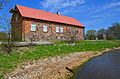 Pāvilosta Local History Museum. The oldest building in the town
 -
 Pāvilosta Culture House


See also
[edit]References
[edit]- ^ "Reģionu, novadu, pilsētu un pagastu kopējā un sauszemes platība gada sākumā". Central Statistical Bureau of Latvia. Retrieved 31 July 2024.
- ^ "Iedzīvotāju skaits pēc tautības reģionos, pilsētās, novados, pagastos, apkaimēs un blīvi apdzīvotās teritorijās gada sākumā (pēc administratīvi teritoriālās reformas 2021. gadā)". Central Statistical Bureau of Latvia. Retrieved 19 June 2024.
- ^ "ISG020. Population number and its change by statistical region, city, town, 21 development centres and county". Central Statistical Bureau of Latvia. 2020-01-01. Retrieved 2021-02-12.
- ^ "Klimatisko normu dati". Latvian Environment, Geology and Meteorology Centre. Retrieved March 27, 2023.
- ^ "Gaisa temperatūras rekordi". Latvian Environment, Geology and Meteorology Centre. Retrieved March 27, 2023.
- ^ "World Meteorological Organization Climate Normals for 1981-2010". National Oceanic and Atmospheric Administration. Retrieved April 5, 2023.
| International | |
|---|---|
| National | |